We are opening up the briefing that we sent to our corporate clients on the morning of Tuesday, September 27, 2022, to the public on the major threat Hurricane Ian poses to the western Florida coast, including the Tampa Bay area. Find out how to get these briefings for your business by clicking the button below. We hope that everyone is preparing ahead of the storm and that those in the path stay safe. We will also continue to have updates on the storm on our Weather Videos page.
Ian To Strike The Western Florida Coast Near Tampa Later This Week
Praedictix Briefing: Tuesday, September 27th, 2022
Key Messages:
- Ian has strengthened into a major hurricane and is sitting over western Cuba this morning. This system will continue to move toward Florida over the next few days with a mid to end of week landfall possible near Tampa.
- This storm will potentially be one of the worst-case scenarios for the Tampa Bay and western Florida coast due to where it is expected to come inland.
- Major storm surge can be expected along the western Florida coast – especially in the Tampa Bay area south to Bonita Beach where a storm surge up to 10 feet will be possible. Storm surge could start as early as today in southern Florida, lasting through at least Thursday along the western coast.
- Tropical storm force winds could impact much of the Florida Peninsula over the next few days as the storm grows in size, with 110+ mph hurricane winds possible from Ft. Myers to Tampa.
- Heavy rain and flooding will also impact Florida and the Southeast.
- If this were to strike the Tampa Bay region as a major (Category 3+) hurricane, it would be the first since 1921.
- A reminder that 88% of tropical system deaths are due to storm surge, rainfall flooding, high surf and deaths just offshore (within 50 nautical miles of the coast).
- Preparations should be rushed to completion within the next day, as conditions will start to deteriorate today into Wednesday with rain and tropical storm force winds moving in.
- Ahead of Ian in Florida, I-4 was jammed with cars overnight heading away from the Tampa area, MacDill Air Force Base is evacuating, and airports and schools in the path are closing.
- Mandatory and voluntary evacuations have been ordered along portions of the western Florida coast, including parts of Tampa Bay. Make sure you know your evacuation zone and follow any evacuation orders from local authorities. For more on evacuation zones in Florida, click here. To find your zone, click here.
- We’re also tracking excessive heat in the Los Angeles area today.


Hurricane Ian. Ian became a major hurricane overnight and is over western Cuba this morning, bringing the region high winds and life-threatening storm surge. As of 8 AM EDT, Ian was located about 10 miles north-northeast of the city of Pinar del Rio, Cuba, or about 130 miles south-southwest of the Dry Tortugas. Ian had sustained winds of 125 mph and was moving north at 12 mph.
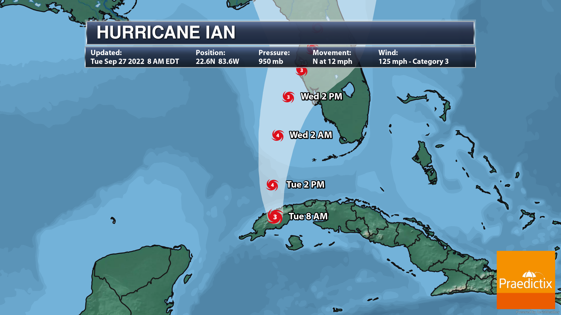

Ian Continues To Be A Major Threat To Florida. Ian will continue to move in a northward direction, bringing it to Florida over the next couple of days. Here’s a breakdown of some of the track details:
- Once Ian emerges into the Gulf of Mexico, strengthening will occur over the next 24 hours, with Ian expected to reach Category 4 strength during this time.
- Strengthening is expected to come to a halt in about the 24-to-36-hour timeframe as the system encounters a more hostile atmospheric environment.
- Do not focus on the fact that this system is expected to weaken near landfall!
- While the wind speeds will decrease, the system is expected to slow down in forward speed as we approach landfall, with Ian also becoming a larger system.
- With the system slowing down, major storm surge impacts will be felt across much of the western Florida coast, with several high tide cycles from late tonight through Thursday impacted. Storm surge causes ocean water to “surge” inland, resulting in normally dry areas to flood.
- Even with lower wind speeds, we will see significant wind impacts along the west coast of Florida and the potential of tropical storm force winds across much of the state through the mid/end of week timeframe. The strongest winds will be near/in the eyewall.
- This track is one of the worse-case scenarios for the Tampa Bay area south along parts of the coast due to the expected storm surge and potential of the high winds with the eyewall passing over the region.
- There still is some uncertainty in the overall track of the storm as it approaches Florida. However, do NOT focus directly on the exact track of the storm, as impacts from this storm (heavy rain/flooding, high winds, and storm surge) will extend far outward from the center of Ian.

Tropical Alerts. Ahead of the path of Ian, a swath of tropical alerts is in place. Note that tropical alerts are only associated with the wind component of tropical systems and do not account for storm surge, heavy rain, or tornadoes. The following tropical alerts are in place:
- Hurricane Warning
- Cuban provinces of Isla de Juventud, Pinar del Rio, and Artemisa
- Bonita Beach to the Anclote River, including Tampa Bay
- Dry Tortugas
- Tropical Storm Warning
- Cuban provinces of La Habana, Mayabeque, and Matanzas
- Lower Florida Keys from Seven Mile Bridge westward to Key West
- Flamingo to Bonita Beach
- Suwannee River to the Anclote River
- Volusia/Brevard County Line south to Jupiter Inlet
- Lake Okeechobee
- Hurricane Watch
- North of Anclote River to the Suwannee River
- Tropical Storm Watch
- North of the Suwannee River to Indian Pass
- Altamaha Sound to Volusia/Brevard County line
- Deerfield Beach to Jupiter Inlet
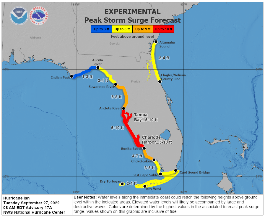
Storm Surge Potential. One of the big threats along the coast with tropical systems is storm surge – where dry areas near the coast are flooded by rising water moving inland.
- Storm surge flooding could begin late today in Southern Florida and along the western Florida coast Wednesday, lasting into at least Thursday in these areas due to the larger size and slow movement of Ian.
- The greatest storm surge would be expected to be near and south of the center of landfall.
- If peak surge occurs at high tide, we could see a storm surge of 5-10 feet from Anclote River to Bonita Beach, including Tampa Bay and Charlotte Harbor.
- Storm surge of 2-4 feet will also be possible on the Atlantic side from the Flagler/Volusia County Line north to Altamaha Sound.


Possible Inundation Around Tampa and Ft. Myers. As previously mentioned, this is pretty much one of the worst-case scenarios for Tampa Bay and parts of the western Florida coast if Ian stays on this track as a dangerous storm surge is expected to inundate areas from Tampa Bay southward.

Storm Surge Alerts. Storm Surge Warnings are in place around the Tampa Bay area southward along the western Florida coast due to the expected storm surge conditions shown above, with Storm Surge Watches in the Big Bend Area and along the northeast Florida/southeast Georgia coasts. Here is the exact breakdown of where they are in place:
- Storm Surge Warning:
- Anclote River southward to Flamingo
- Tampa Bay
- Storm Surge Watch:
- Florida Keys from the Card Sound Bridge westward to Key West
- Dry Tortugas
- Florida Bay
- Aucilla River to Anclote River
- Altamaha Sound to Flagler/Volusia County Line
- Saint Johns River
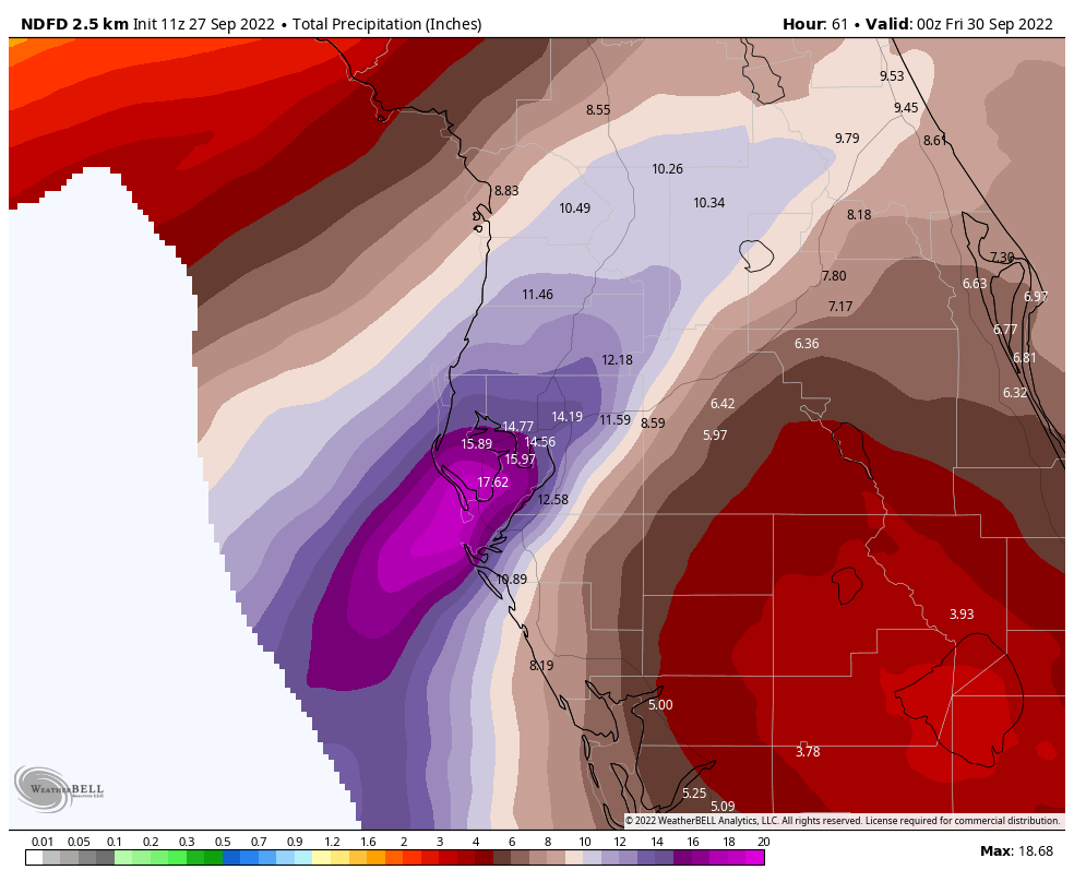
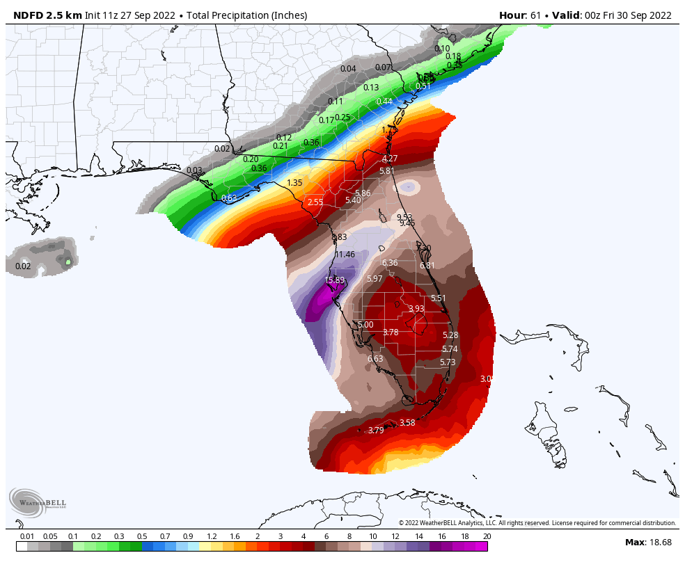
Rain maps through 8 PM Thursday evening.
Flooding Rain Threat. Heavy rainfall is expected to impact Florida and the Southeastern United States through the end of the week and into the weekend that will bring widespread flash and urban flooding to the region.
- Rainbands associated with Ian are already impacting parts of southern Florida this morning.
- Heavy rainfall will continue across Florida through the middle of the week, with the rain threat spreading into the rest of the Southeast and even the Mid-Atlantic late week into the weekend.
- The combination of storm surge and heavy rain will potentially compound flooding issues near the coast.
- Through Thursday night, here are expected rainfall amounts:
- Western Cuba: 6 to 12 inches, with isolated totals up to 16 inches. These rains may produce flash flooding and mudslides in areas of higher terrain over western Cuba.
- Florida Keys and South Florida: 4 to 6 inches, with isolated totals up to 8 inches
- Central West Florida: 12 to 16 inches, with isolated totals up to 24 inches.
- Northeast Florida and the remainder of the Central Florida Peninsula: 5 to 10 inches, with isolated totals up to 12 inches.

Flood Potential Next Three Days. The greatest flood threat from tropical rainbands associated with Ian will move northward across the Florida Peninsula over the next three days, starting off over southern Florida today and ending up over northern Florida and southern Georgia Thursday.
- Note that many areas of the Florida Peninsula that could be impacted by these heavy rains have received at least 200% of normal precipitation over the past 30 days, meaning that the ground is already saturated and could exacerbate flooding conditions across the region.

Seven Day Flood Threat. The National Water Center shows that a considerate flood threat – meaning that significant flash flood and/or moderate river flooding is expected – will occur due to the heavy rainfall associated with Ian across central and northern Florida, southeastern Georgia, and coastal South Carolina from the mid-week to weekend timeframe. Rivers in the Tampa area are expected to reach moderate flood stage, with tidal gauges in Savannah and Charleston expected to reach major stage at high tide near midday Thursday.

High Wind Threat. Winds will be on the increase during the mid-week timeframe ahead of the path of Ian across Florida.
- While a weakening trend is expected closer to landfall, that doesn’t mean the high wind threat will be ending. In fact, the wind field is expected to expand and impact more areas, and with a slower movement we can expect stronger winds over locations for a longer period of time.
- The highest winds are expected from Ft. Myers northward to the Tampa Bay area and Homosassa Springs, where the National Weather Service currently shows the potential of 110+ mph winds.
- Hurricane conditions are possible as soon as tomorrow across the region, lasting into Thursday.


Tampa Expected Winds. On the current track of Ian, the highest winds are expected to impact the Tampa area during the overnight hours Wednesday night into Thursday morning. During this timeframe, especially early Thursday morning, wind gusts of at least 100 mph will occur.
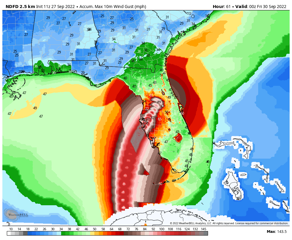
Florida Expected Winds. Hurricane force wind gusts are expected to make it northwest of Orlando as the system slowly moves inland into Thursday, but widespread 40+ mph winds are possible across a wide swath of Florida that could cause damage.

Arrival Time Of Tropical Storm Force Winds (39+ mph). Any preparations ahead of Ian should be rushed to completion over the next day or so, especially the farther south along the Florida Peninsula you are.
- During the afternoon hours today, tropical storm force winds will start to impact the Florida Keys.
- By Wednesday morning, wind speeds are expected to pick up to tropical-storm force in the Tampa Bay area.
- These stronger winds will reach northern Florida into Thursday, and into the Atlanta area by Friday evening.
- Once these winds pick up to this speed, it makes additional preparations difficult to complete – and a sign that the storm is starting to bare down on the region.

Isolated Tornadoes. Tropical rainfall bands also produce a tornado threat, and we will see that threat across the Florida Peninsula through the middle of the week.

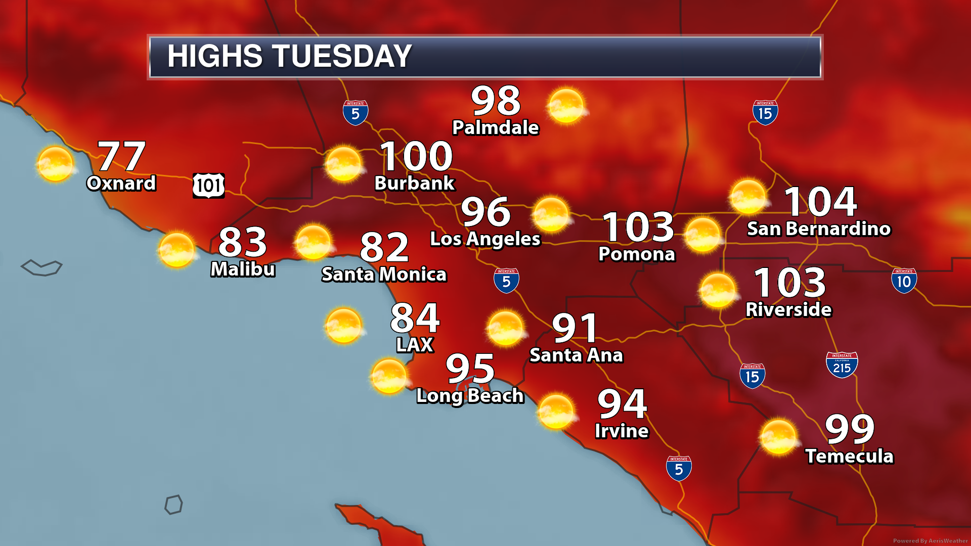
Los Angeles Excessive Heat. We’re also tracking excessive heat today across portions of southern California, including Los Angeles. Dangerously hot conditions are expected with high temperatures in the 90s and 100s, which will increase the threat of heat-related illnesses. The good news is that this won’t be as extreme as the event earlier this month across the region. The Excessive Heat Warning for Los Angeles ends tonight at 8 PM.
D.J. Kayser, Meteorologist, Praedictix
Follow Praedictix Weather On Social Media:
Follow Meteorologist D.J. Kayser On Social Media:

