
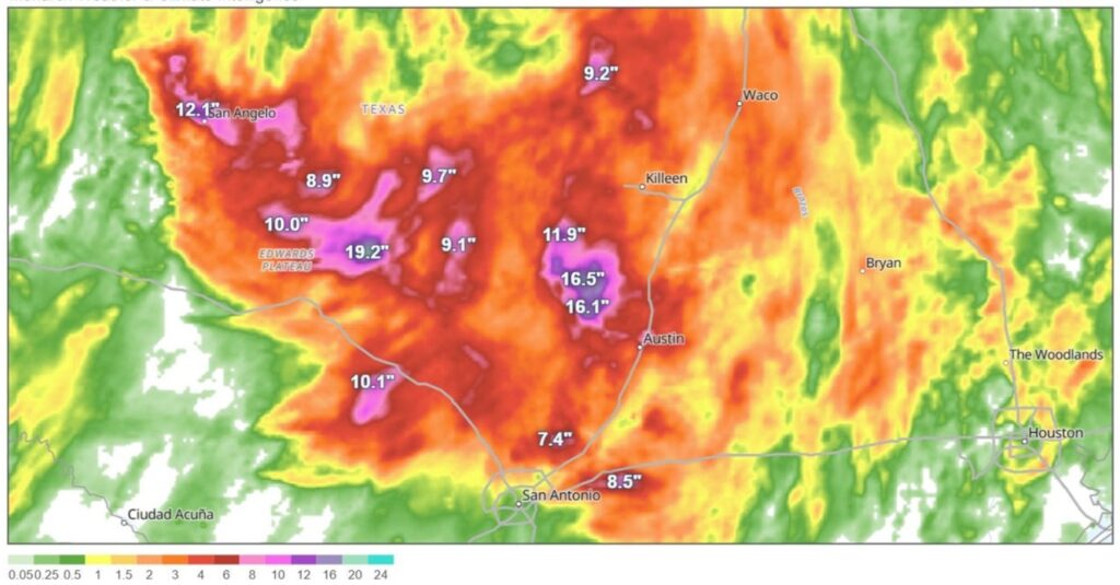
Credit: rainfall total map courtesy of MonarchView
5 Key Ingredients That Led To Deadly Texas Flooding. Forbes does a good job breaking down the factors in creating a 1-in-500 to 1-in-1000 year flood over the Hill Country of Texas: “It has been a week since the catastrophic flooding in Texas Hill Country. The death toll has so far exceeded 120 people, with roughly 170 still missing. As the tragedy unfolds, important questions are being raised about the lack of a real-time warning system, why certain infrastructure is located in a known floodplain and barriers to disseminating available weather warnings. If this were a plane crash, the National Transportation Safety Board would investigate what happened. There is no such function for weather disasters, though many of my colleagues have called for this capability over the years. In light of that void, here is a breakdown of five key meteorological ingredients that contributed to the Texas floods…”
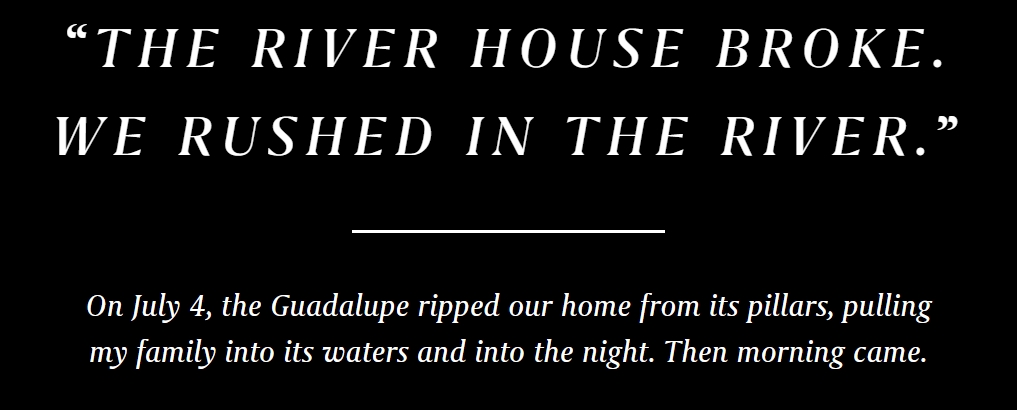
“The River House Broke. We Rushed in the River”. A blow by blow account from one eyewitness of the horrific flash flooding that impacted the Guadaloupe River Valley in Texas on the 4th of July, courtesy of TexasMonthly: “Rosemary, the four-year-old, woke up first. She told my brother-in-law, Lance, that there was something on the roof. Seven of us were at my family’s river house on the Guadalupe, between Ingram and Hunt, for the Fourth. Our little stretch of river is wide, green, cool, deep, and slow. It is some of the best swimming anywhere and one of the most beautiful spots in Texas, as far as I’m concerned. I’ve spent many peaceful afternoons there, floating and staring up at the cypress trees that tower over the water. The house, a one-story cabin on stilts about fifty yards from the river up our steeply sloped yard, was built right after the 1987 flood that devastated this region, killing ten teenagers. Concrete pillars put our family’s place a few feet above what officials consider a one-hundred-year floodplain. More than once I’d tried to imagine the waters rising that high, but it seemed impossible...”
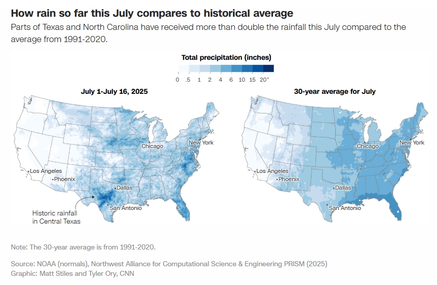
Credit: Note: The 30-year average is from 1991-2020.
Source: NOAA (normals), Northwest Alliance for Computational Science & Engineering PRISM (2025)
Graphic: Matt Stiles and Tyler Ory, CNN
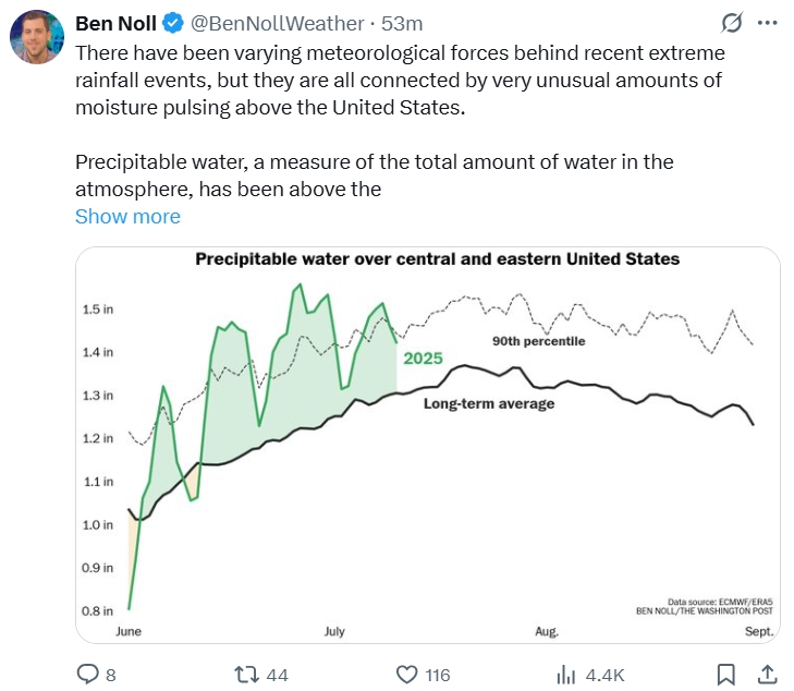
This is the Summer of Flooding Across the US, and Scientists Know Why. Here’s a clip from a good explainer at CNN.com: “…It’s no accident this is the summer of flooding, climate scientists say, with 100-year to 1,000-year deluges happening nearly simultaneously in multiple states on multiple days. Large parts of the US have seen an unusually humid summer with record amounts of moisture in the air. When cold fronts and other weather systems come along, that moisture can get wrung out, squeezed like a water-laden sponge, yielding heavy and often highly localized downpours. For much of the summer, the atmospheric conditions over the US have funneled humid air north from the unusually warm Gulf and western Atlantic, including the Gulf Stream, UCLA climate researcher Daniel Swain told CNN…”
Credit: Paul Douglas
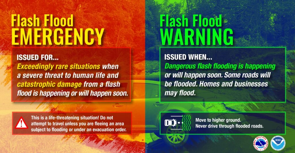
How Flood Sirens Could Have Saved Lives in Texas. NPR reports on technology that has been used for tornadoes for decades, and how sirens may help to increase awareness, especially at night when people are sleeping: “In the wake of the deadly flash floods in Texas on July 4, Texas leaders are betting on the lifesaving potential of flood warning sirens. “What can we do better looking forward? We need sirens,” said Texas Lt. Gov. Dan Patrick in an interview this week with NBC 5 in Dallas-Fort Worth. The floods killed at least 120 people. Weather warning sirens are installed outside on tall poles and make a loud wailing sound to warn people in the area when water levels rise, signaling an imminent flood. Some also broadcast spoken warnings and directions about how to get to safety. These types of sirens are widely used in the United States to warn people about tornadoes and tsunamis but are much less common in areas that flood. “If you had sirens blasting,” Patrick said, “and if people had known ‘if you hear a siren get to high ground,’ maybe that would have saved some lives...”
Around the World, Flash Flood Disasters are the “Hardest Kind to Prevent”. The New York Times (paywall) provides context: “…But global experts in early warning systems said that there are few examples of places around the world that have mastered the choreography of forecasting and communication needed to prevent loss of life in extreme rain events. And in many cases, like in Texas this month, accurate forecasting alone is not enough to prevent calamity. “Flash floods are the hardest kind of disaster to prevent,” said Erin Coughlan de Perez, who studies disaster risk management at Tufts University. She said that both rich and poor countries have grappled with funding for systems that ultimately either fail or create enough false alarms to erode public confidence…”
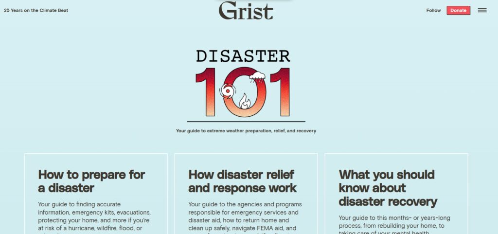
Credit: https://grist.org/extreme-weather/disaster-preparation-recovery-resources/
Inside Grist’s Toolkit for Navigating Disasters. NiemanLab has details on a good database to bring consumers up to speed on extreme weather readiness: “…Navigating a disaster — before, during, and after it hits — can be overwhelming, and often involves a maze of agencies and regulations at local, state, and federal levels that you have never even heard of previously. And between the one-two punch of deteriorating local news and increasing misinformation on social media, even finding accurate information about the disaster can be hard. So Grist, the nonprofit climate publication, put together a toolkit to help. It’s called Disaster 101, and it walks readers through every stage of a disaster, from making preparations ahead of a disaster to riding it out and navigating the maze of resources that are available in the aftermath. It’s made for sharing and adapting — by community organizers, local governments, and news outlets alike — and designed so that people with limited internet access can still access the most salient resources...”
Credit: NOAA, National Weather Service
Why it Can Be so Hard to Warn People About Dangers Like Floods – Communication Researchers Explain the Role of Human Behavior. More interesting context on the difficulties of communicating flood risk from The Conversation: “…Flash floods like the one that swept down the Guadalupe River in Texas on July 4, 2025, can be highly unpredictable. While there are sophisticated flood prediction models and different types of warning systems in some places, effective flood protection requires extensive preparedness and awareness. It also requires an understanding of how people receive, interpret and act on risk information and warnings. Technology can be part of the solution, but ultimately people are the critical element in any response. As researchers who study emergency communications, we have found that simply providing people with technical information and data is often not enough to effectively communicate the danger and prompt them to act…”
Source: NOAA, Climate Central
Trump is Gutting Weather Science and Reducing Disaster Response. At some point you’re cutting into bone, not fat. The New York Times examines escalating risk: “In an effort to shrink the federal government, President Trump and congressional Republicans have taken steps that are diluting the country’s ability to anticipate, prepare for and respond to catastrophic flooding and other extreme weather events, disaster experts say. Staff reductions, budget cuts and other changes made by the administration since January have already created holes at the National Weather Service, which forecasts and warns of dangerous weather. Mr. Trump’s budget proposal for the next fiscal year would close 10 laboratories run by the National Oceanic and Atmospheric Administration that research the ways a warming planet is changing weather, among other things…”
Source: NOAA, Climate Central

Why Texas’ Floods area a Warning for the Rest of the Country. POLITICO reports; here’s an excerpt: “…Even without final answers about the cause of the Texas death toll, one longtime emergency manager said one fact is clear: “That many people did not need to die,” said Michael Coen, who served as FEMA’s chief of staff during the Biden and Obama administrations. He said Kerr County should have invested in better flood defenses or, at the very least, relocated camping cabins away from the river. The gutting of the national infrastructure around weather emergencies comes at the same time that climate change is making severe disasters more common and more dangerous, according to studies and past warnings from the U.S. government — including during the first Trump administration…”
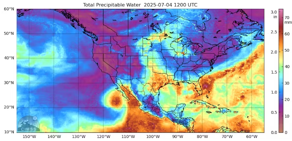
Credit: A satellite captured atmospheric water vapor at the time of the Texas floods on July 4, 2025. The values of 2.5 inches are an inch more than normal for that time of year. Space Science & Engineering Center/University of Wisconsin-Madison
Why 2025 Became the Summer of Flash Flooding in America. Good perspective from The Conversation; here’s an excerpt: “…Overall, a persistent atmospheric pattern in late spring and summer 2025 has included a shift of the jet stream farther to the south than normal and, along with lower atmospheric pressures, has supported excessive rainfall across the central and eastern U.S. While the West Coast has experienced dry conditions in early summer 2025 due to a ridge of high pressure, the U.S. east of the Rockies has seen an active storm track with frontal boundaries and disturbances that produced thunderstorms and intense downpours across the region. Warmer-than-normal ocean water can also boost rainfall. The Caribbean and the Atlantic Ocean are source regions for atmospheric water vapor in the central and eastern U.S…”
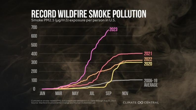
Image credit: Climate Central
America’s Coming Smoke Epidemic. You’re not imagining it – we are seeing more days where wildfire smoke is negatively impacting air quality. The Atlantic takes a look at nationwide smoke trends; here’s an excerpt: “…Migliaccio’s work can speak to only a single smoke event. But it is the type of event that more people in the United States are dealing with, over and over again. Until recently, wildfires that exposed large populations to smoke were a relatively rare occurrence. But that’s changing: More frequent and intense wildfires are erasing or even reversing decades of gains made in American air quality in the majority of U.S. states. Across the country, from 2012 to 2022, the number of people exposed to unhealthy air from wildfire smoke increased 27-fold; one out of every four unhealthy air days in parts of the country is now a smoke day. “It is the exposure that is impacting air quality across the U.S. now more than any other pollution source,” Joan Casey, an environmental epidemiologist at the University of Washington whose work helped show a link between wildfire-smoke exposure and increased risk of dementia, told me…”

Credit: The NOAA G-IV prepares for takeoff in Honolulu, Hawaii, during the El Nino Rapid Response field campaign. (Photo by Janet Intrieri, NOAA)
New Study Shows Hurricane Hunter Flights Significantly Increase Forecast Accuracy. University at Albany has the details of something we’ve long suspected: “When a hurricane is in the forecast, the National Oceanic and Atmospheric Administration (NOAA) deploys its famed Hurricane Hunter team to gather data directly from the storm. The team uses specialized aircraft to fly into the hurricane and collect information about its intensity, structure, and movement, which is used to improve forecasts and warnings. These missions significantly increase the accuracy of hurricane forecasts, according to a new study published in Weather and Forecasting by researchers at the University at Albany. The researchers focused on Hurricane Hunter missions conducted with NOAA’s Gulfstream IV, often called G-IV jet, during recent Atlantic hurricane seasons…”
Credit: NOAA
Weather Service Hiring Back Hundreds of Positions That Got Caught in the DOGE Chaos. CNN reports: “The National Weather Service has received permission to hire 450 meteorologists, hydrologists and radar technicians just months after being hit hard by Department of Government Efficiency-related cuts and early retirement incentives. The new hiring number includes 126 new positions that were previously approved and will apply to “front-line mission critical” personnel, a National Oceanic and Atmospheric Administration official told CNN. The NWS cuts have spurred concerns over how well-prepared the country is to withstand hurricane season, which is just starting to heat up in the Atlantic…”

White House Proposal Could Gut Climate Modeling the World Depends Upon. Maybe if we ignore it climate change will magically go away? Probably not – the symptoms are becoming apparent with each passing year. ProPublica has the post; here’s the intro: “Over the past two months, the Trump administration has taken steps to eliminate regulations addressing climate change, pull back funding for climate programs and cancel methods used to evaluate how climate change is affecting American society and its economy. Now it is directly undermining the science and research of climate change itself, in ways that some of the nation’s most distinguished scientists say will have dangerous consequences. Proposed cuts to the National Oceanic and Atmospheric Administration, the agency whose weather and climate research touches almost every facet of American life, are targeting a 57-year-old partnership between Princeton University and the U.S. government that produces what many consider the world’s most advanced climate modeling and forecasting systems...”
Credit: NASA Goddard
Global Warming Didn’t Cancel Winter. It Just Made it Weirder. SciTechDaily published an explainer that caught my eye; here’s a clip: “…The team identified two distinct variations of the polar vortex, both linked to what scientists call a “stretched” vortex—a distorted and displaced circulation pattern that leads to unusual weather on the ground.
- One variation pushes the vortex toward western Canada, setting the stage for intense cold in the Northwestern U.S.
- The other nudges the vortex toward the North Atlantic, unleashing frigid air across the Central and Eastern U.S.
Both versions are associated with changes in how atmospheric waves bounce around the globe—essentially altering the jet stream and dragging Arctic air far southward...”
Credit: StudyFinds
Winter Weather is Moving West: How the Polar Vortex is Rewriting America’s Cold Map. More good perspective on new research from StudyFinds; here’s an excerpt: “…The culprit? Changes in the polar vortex, that massive, spinning ring of cold air that sits high above the Arctic. When this atmospheric giant wobbles in different directions, it determines which parts of America get pummeled by winter’s worst conditions. Scientists analyzed 42 years of weather data and discovered two distinct polar vortex patterns that each deliver misery to different regions. Since 2015, one pattern has become dramatically more common, explaining why places like Montana and Washington are seeing more severe winter weather while traditional East Coast snow zones experience somewhat less...”