Minnesota Has Escaped 2020’s Worst Disasters
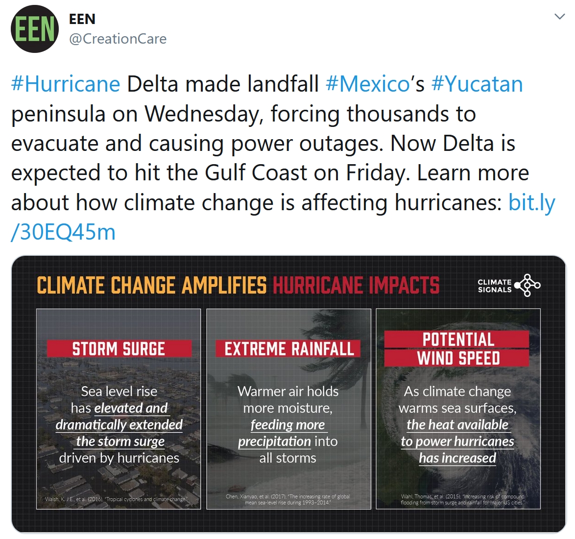
Don’t let anyone living in Louisiana ever give you a hard time about Minnesota weather. Hurricane Delta will be the 6th tropical system in 2020 to impact Louisiana, still recovering from Hurricane Laura’s aftermath in late August.
“Delta” will come ashore along the Louisiana coastline late Friday as a major, Category 3 storm, with sustained winds of 120 mph.
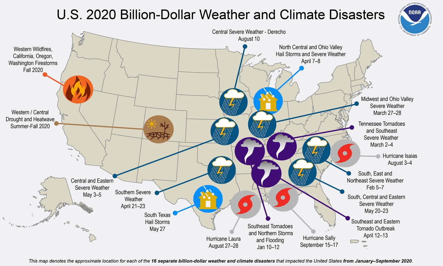
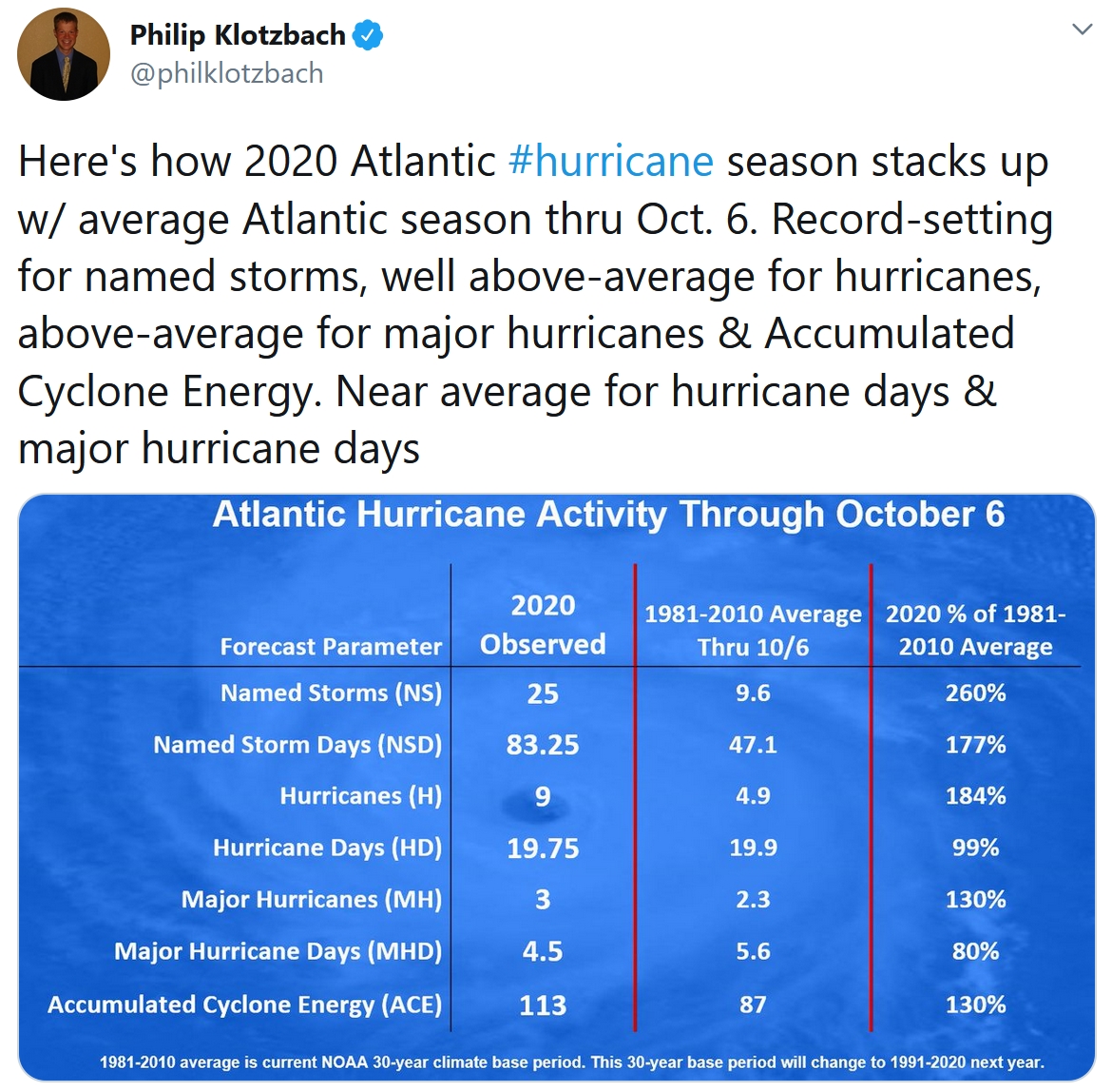
According to NOAA, there have been 16 billion-dollar disasters in the USA in 2020, 6 of those since June. From unprecedented western fires to hurricanes to 140 mph gusts from an August 10 derecho in Iowa, this is a record 6th year in a row with at least 10 billion-dollar disasters.
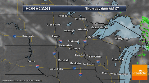
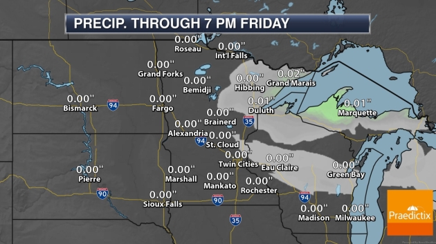
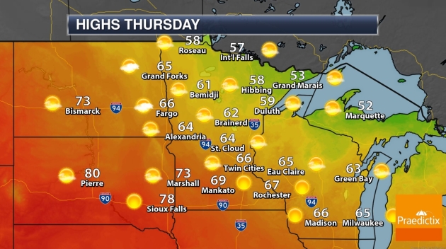
Expect a glorious Thursday with light winds. Low 80s return Friday, before we cool off slightly on Saturday. The best chance of rain and T-storms will come Monday, followed by a parade of cooler fronts next week.
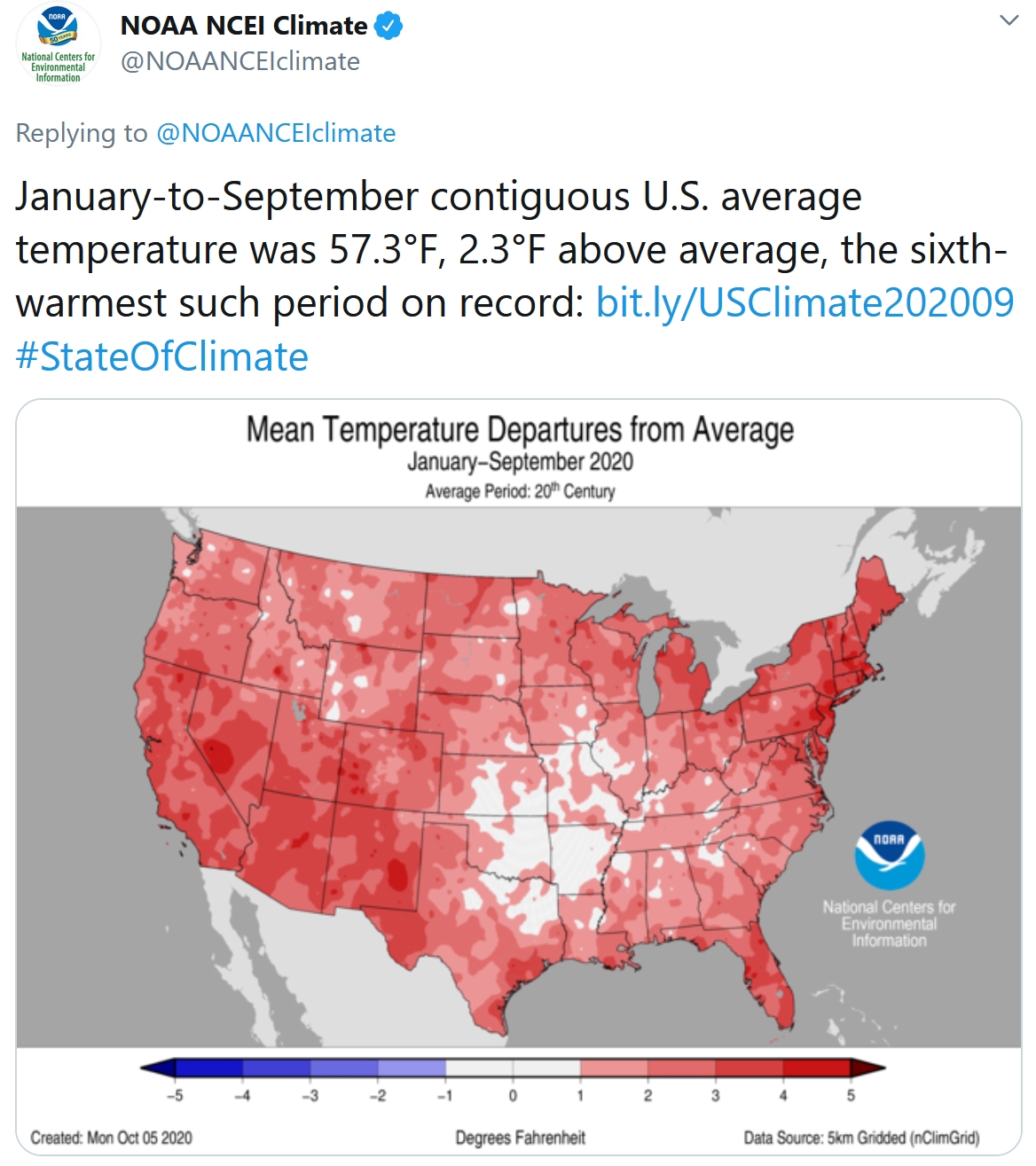
NOAA reports nationwide temperatures ran 2.3F above average since January 1; the 6th warmest such period on record. It’s not a fluke – scientists say it’s a trend.
U.S. Hit by 16 Billion-Dollar Disasters This Year, So Far. NOAA has an update on another crazy year of weather extremes: “…From January through the end of September of this year, the U.S. has experienced 16 weather and climate disasters with losses exceeding $1 billion each. Eleven were due to severe storms—which occurred across more than 30 states—and the remaining 5 comprised one wildfire, one drought and three tropical cyclones. With 16 disasters so far, 2020 has already tied with 2011 and 2017 for the largest number of disasters in a calendar year. This is also a record sixth-consecutive year where 10 or more billion-dollar disasters have struck the U.S...”
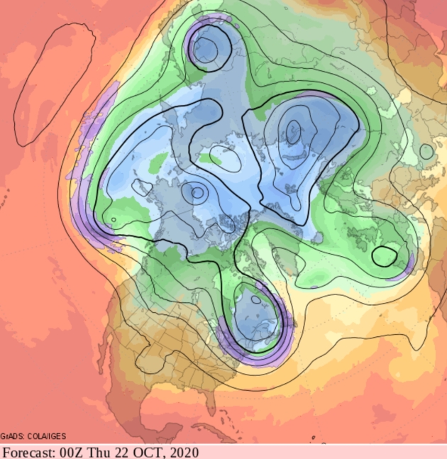
Flip-Flopping Model Runs. Yesterday’s GFS solution looking out 2 weeks looked pretty chilly for northern tier states, but the latest prediction suggests more of a west-to-east zonal flow with temperatures fairly close to average across most of the USA.


Praedictix Briefing: Issued Wednesday, October 7th, 2020:
Key Messages:
-
Hurricane Delta made landfall at 6:45 EST in Puerto Morales just south of Cancun, Mexico, as a Category 2 hurricane with maximum sustained winds of 110 mph.
-
Delta is expected to strengthen once again in the Gulf of Mexico back into a major hurricane.
-
The Louisiana coast is at risk for a major hurricane landfall Friday afternoon.
-
The Gulf coast/Lower MS Valley is at risk of dangerous hurricane-force winds, torrential rainfall, widespread flooding, and a life-threatening storm surge. Storm surge and hurricane watches will likely be issued in parts of the northern Gulf Coast later today.
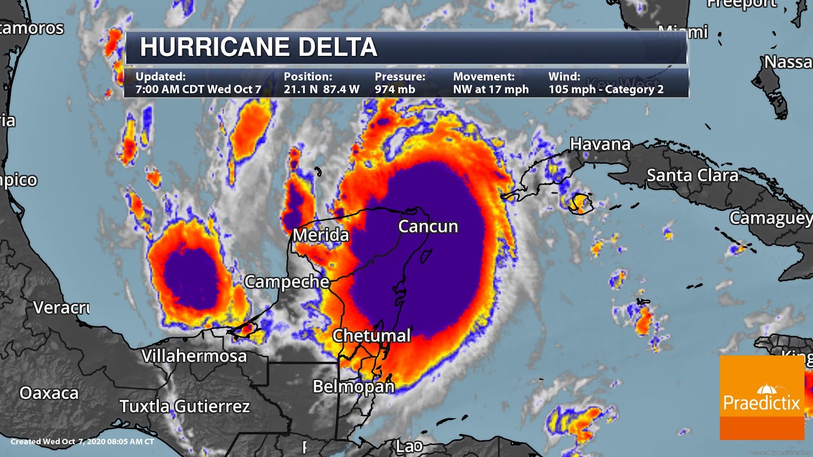
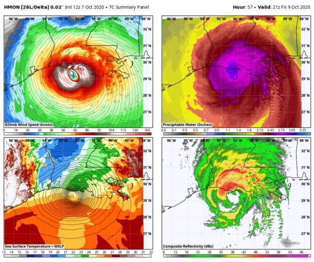
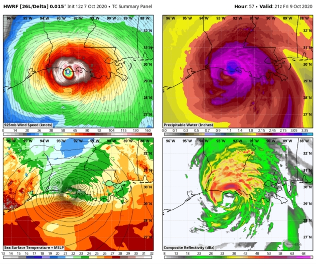
A Category 2 Hurricane. Hurricane Delta is currently impacting the Yucatan peninsula as a Category 2 with maximum sustained winds of 105 mph. The area has reported widespread heavy rainfall, powerful wind, and flooding. A wind gust of 75 mph was measured at Puerto Morelos this morning where landfall occurred. A gust of 64 mph was reported in Cozumel, Mexico. It is currently moving NW and 17 mph.
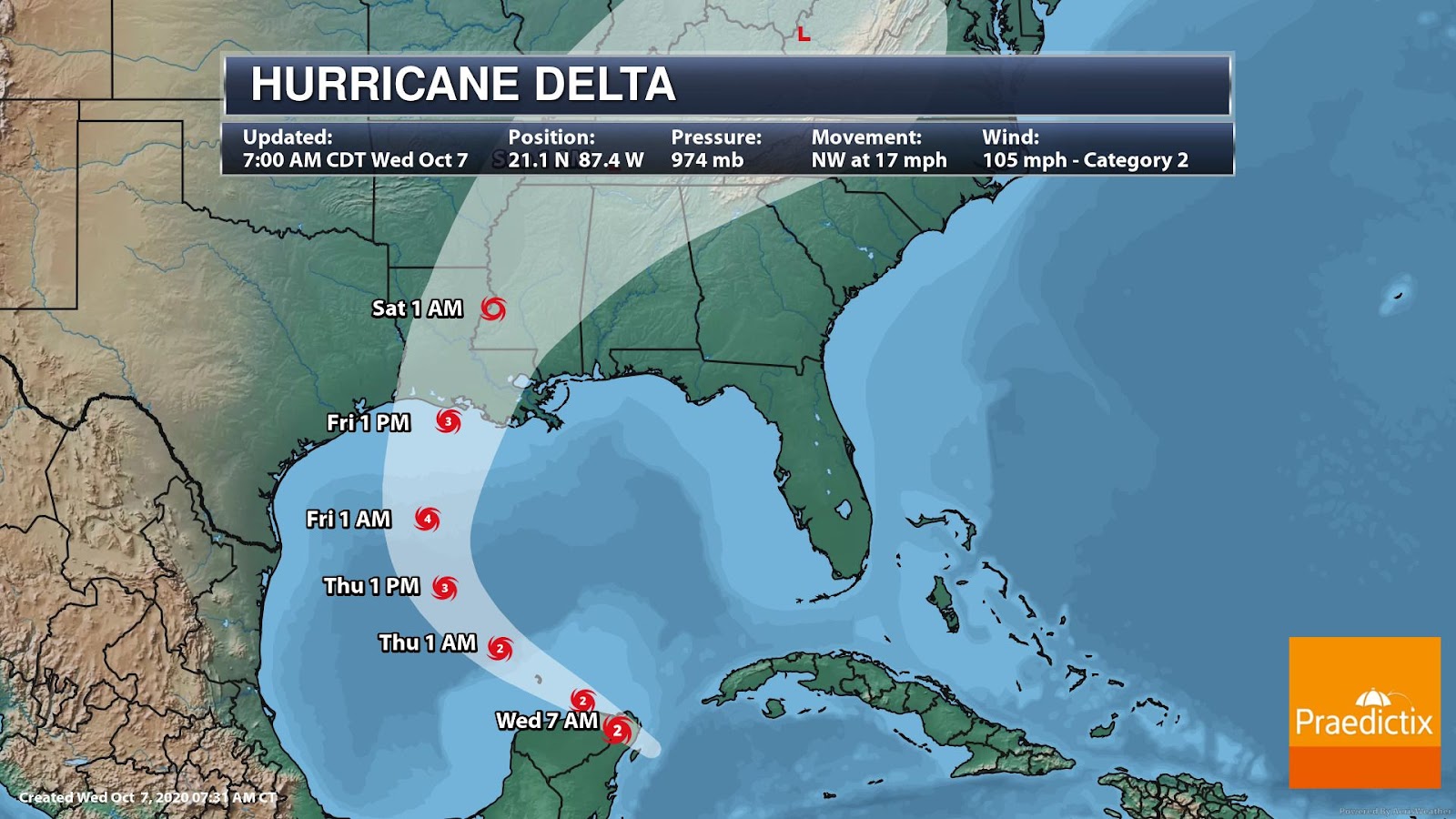
Major Hurricane Landfall Threat for U.S. Gulf Coast. Hurricane Delta will continue to impact the Yucatan today, but will return to the open Gulf waters tonight. A slower NW to NNW motion is expected Thursday with a turn northward by Thursday night/Friday. Conditions are favorable for intensification as it tracks through the Gulf. The majority of hurricane models show Delta restrengthening to a Category 4 hurricane in 36 to 48 hours. However, conditions are less favorable as it nears the Gulf Coast, which will contribute to some weakening. Regardless, Delta remains a formidable hurricane and is still forecast to make landfall as a MAJOR Category 3 Friday afternoon along the Louisiana coast.
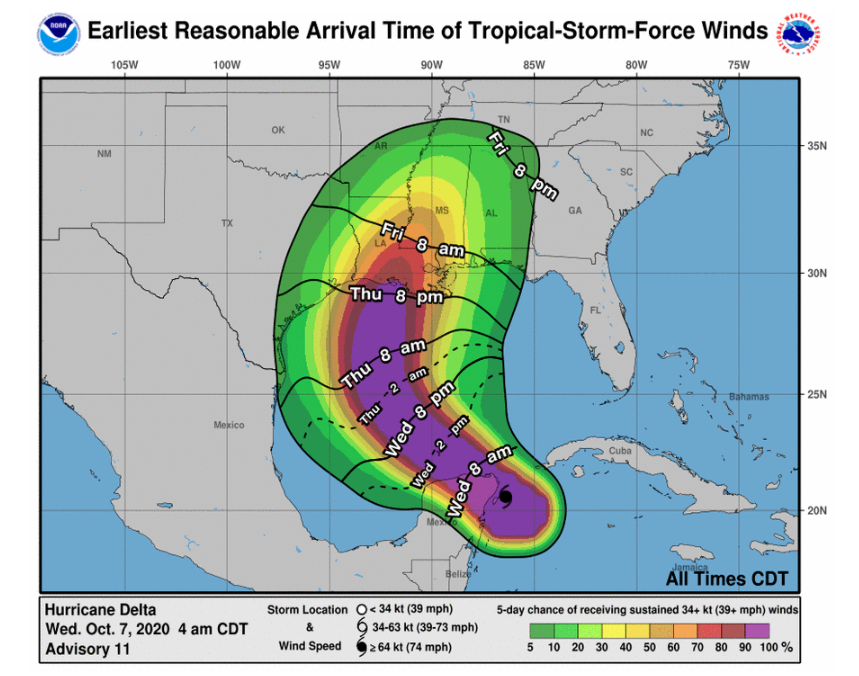
Dangerous Winds. Hurricane Delta is a rather compact storm for now, but still dangerous nonetheless. Hurricane-force winds extend outward up to 30 miles from the center with tropical-storm-force winds extending outward up to 140 miles. Something to note is that Delta’s wind field will likely grow as its intensity drops before making a Gulf Coast landfall. Tropical-storm-force winds are expected to begin for the Central Gulf by Thursday evening.
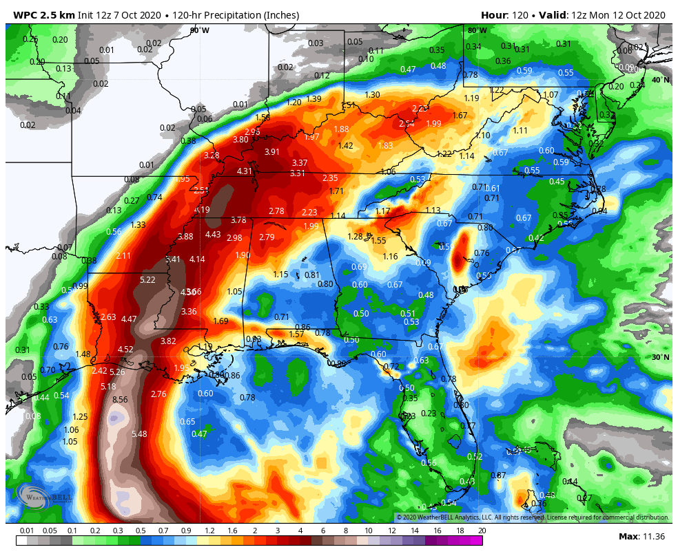
Widespread Rain & Flooding Threat. Torrential tropical rain will drench the Lower Mississippi Valley, the Tennessee Valley, and even the Ohio River Valley. The heaviest precipitation will likely impact Louisiana and Mississippi. Widespread 4 to 8 inches of rain will be possible with isolated maximum totals up to 12 inches across parts of the central Gulf Coast/Lower Mississippi Valley. The risk of flash flooding, urban, small stream, and river flooding is high. Map credit: WeatherBell.
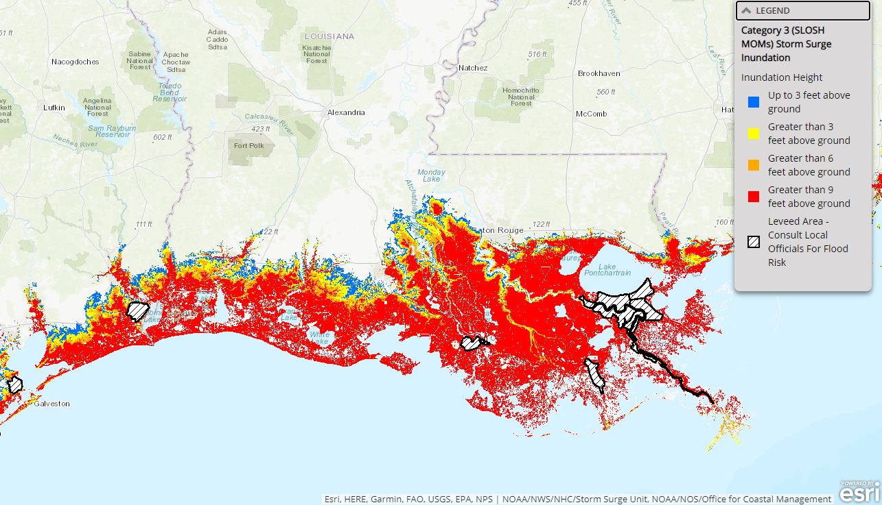
Life-threatening Storm Surge. While the NHC has not yet published an official storm surge forecast for the Gulf Coast, experts agree that Hurricane Delta will likely produce a life threatening, dangerous storm surge for coastal communities. Louisiana, and New Orleans especially, is particularly vulnerable. When combined with high astronomical tides, the storm surge will likely impact coastal communities later this week. The graphic above is a depiction of storm surge vulnerability under a Category 3 hurricane. Both the intensity and the size of the hurricane will ultimately dictate the storm surge potential.
Praedictix Meteorologist Susie Martin.
The U.S. Could See the Fewest Recorded Deaths from Lightning Strikes This Year. One silver lining in during a volatile year of weather extremes. CNN.com reports: “In a year of increasingly bleak headlines, here’s one uplifting piece of news: The US is on track to experience the fewest recorded deaths from lightning strikes in a single year. Fourteen people have died from lightning strikes in the US so far this year. And because peak lightning season in the Northern Hemisphere takes place during June, July and August, the worst is likely behind us. Even if a few more deaths are reported in the next three months, the overall toll will still be below what we usually see, says John Jensenius, a meteorologist and lightning safety specialist with the National Lightning Safety Council…”
File image: NASA.

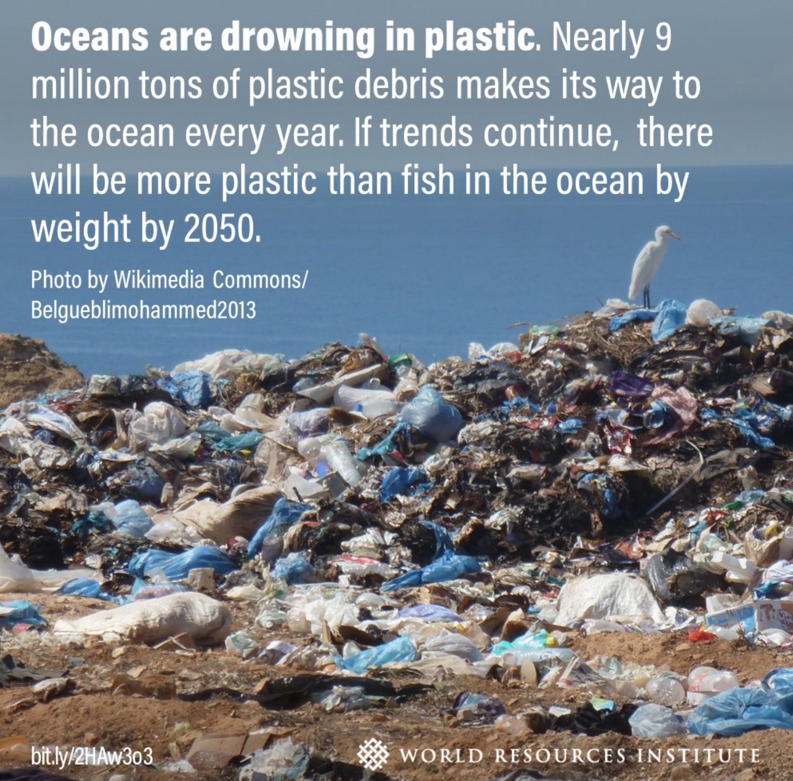
Study: 14 Million Metric Tons of Microplastics on the Ocean Floor. CNN.com has details: “But relatively little is known about the levels of plastic nestled on the sea bed and in the deep-sea sediment at the bottom of our world. A new study from Australia’s national science agency CSIRO and published in the journal Frontiers in Marine Science on Monday, has shed some light on this plastic problem, estimating that there is 14 million metric tons of microplastics sitting on the ocean floor. That’s more than 35 times as much plastic than is believed to be floating on the surface, the study suggests…”
Image credit: World Resources Institute.

Compact Nuclear Fusion Reactor is “Very Likely to Work”, Studies Suggest. If true, this would be a breakthrough of epic proportions. Details via The New York Times (paywall): “Scientists developing a compact version of a nuclear fusion reactor have shown in a series of research papers that it should work, renewing hopes that the long-elusive goal of mimicking the way the sun produces energy might be achieved and eventually contribute to the fight against climate change. Construction of a reactor, called Sparc, which is being developed by researchers at the Massachusetts Institute of Technology and a spinoff company, Commonwealth Fusion Systems, is expected to begin next spring and take three or four years, the researchers and company officials said. Although many significant challenges remain, the company said construction would be followed by testing and, if successful, building of a power plant that could use fusion energy to generate electricity, beginning in the next decade...”
Sparc image credit: “Rendering of SPARC, a compact, high-field, DT burning tokamak, currently under design by a team from the Massachusetts Institute of Technology and Commonwealth Fusion Systems. It’s mission is to create and confine a plasma that produces net fusion energy.” CAD rendering by T. Henderson, CFS/MIT-PSFC.

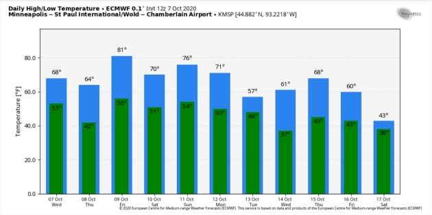
71 F. high in the Twin Cities on Wednesday.
62 F. average high on October 7.
67 F. high on October 7, 2019.
October 8, 1949: A record-setting 3.17 inches of rain falls at Eau Claire.

Now There’s a Dr. Fauci Action Figure. CNN.com has a story that’s perfect for 2020: “…House Speaker Nancy Pelosi and Dr. Anthony Fauci, director of the National Institute of Allergy and Infectious Diseases, are getting the action figure treatment. FCTRY, a Brooklyn-based product design company, said it raised over $200,000 on a Kickstarter page — surpassing its initial $15,000 goal — to help them produce the toys. Dr. Fauci’s figurine is dressed in a white coat and removable mask. The action figure sports the doctor’s signature glasses, and has his stethoscope ready to go in his front pocket…”

Is Listening to “Baby Shark” a Form of Torture? ABC News has another vaguely surreal story: “Two former Oklahoma jail employees and their supervisor face misdemeanor cruelty charges after investigators found they forced inmates to stand handcuffed for hours and listen to the children’s song “Baby Shark” on repeat, a prosecutor said Monday. At least four inmates were secured to a wall with their hands cuffed behind them while the song played on a loop at a loud volume for hours…”
Image credit: YouTube.
THURSDAY: Sunny and glorious. Winds: SE 7-12. High: 68
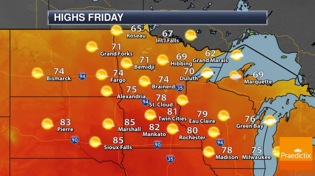
FRIDAY: Warm sunshine. Last 80 of 2020? Winds: SW 10-20. Wake-up: 60. High: 82
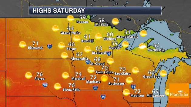
SATURDAY: Blue sky, turning cooler. Winds: NE 8-13. Wake-up: 54. High: 69
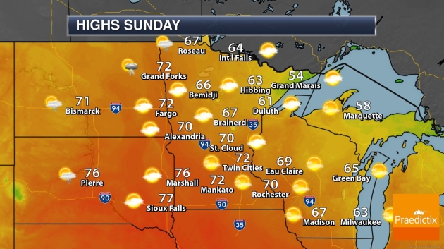
SUNDAY: Fading sun, a windier, milder day. Winds: SE 15-25. Wake-up: 56. High: 75
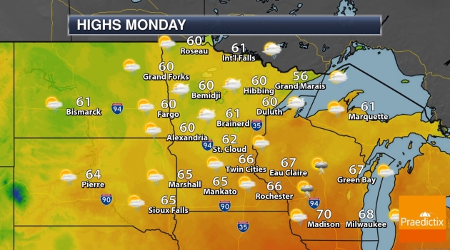
MONDAY: Showers and T-storms arrive. Winds: NW 10-20. Wake-up: 58. High: 69
TUESDAY: Mostly cloudy, cool wind. Winds: NW 10-15. Wake-up: 44. High: 58
WEDNESDAY: Mostly sunny and milder. Winds: S 7-12. Wake-up: 41. High: near 70
Climate Stories…
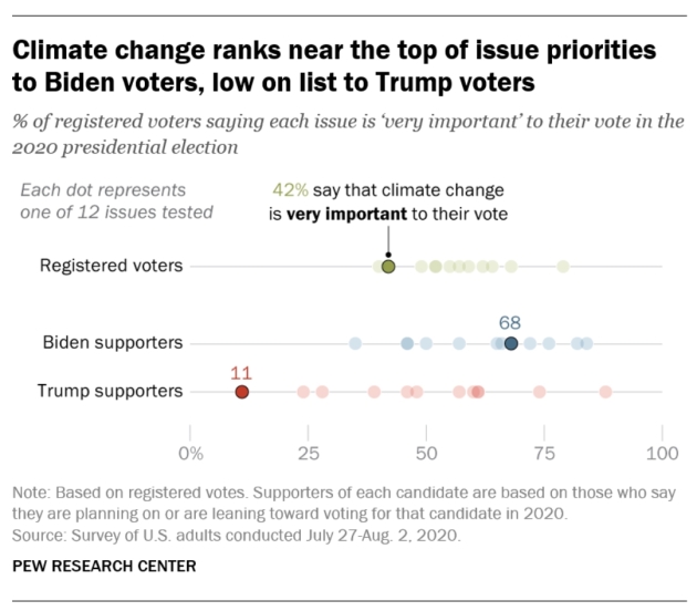
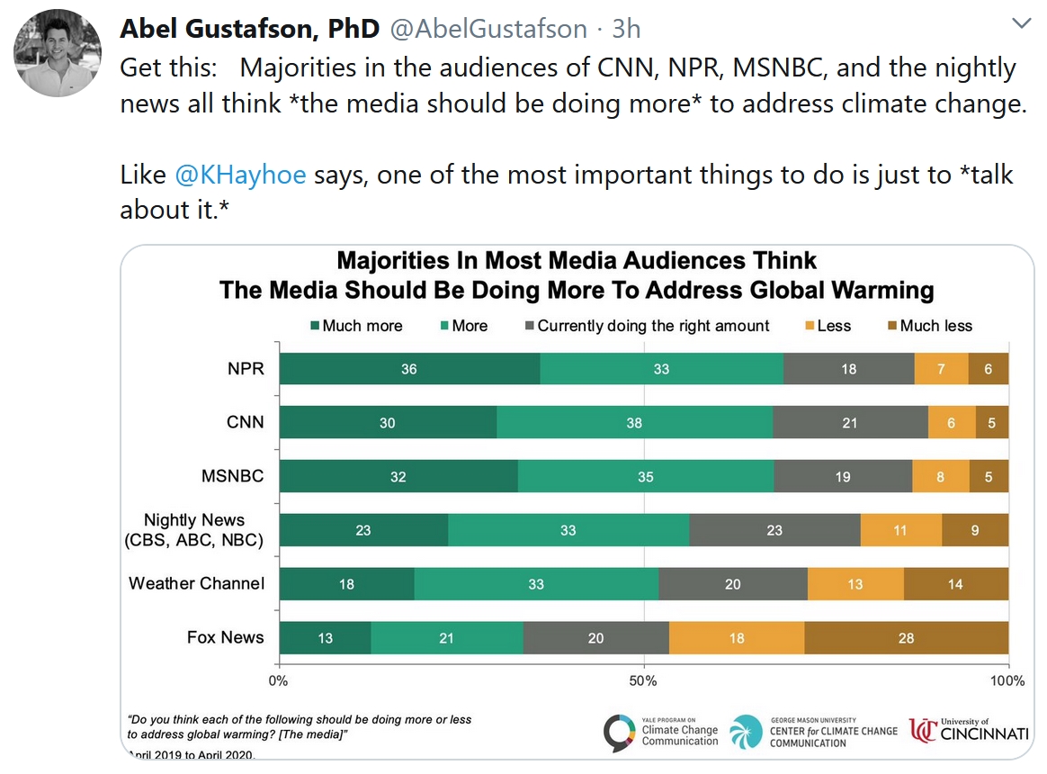
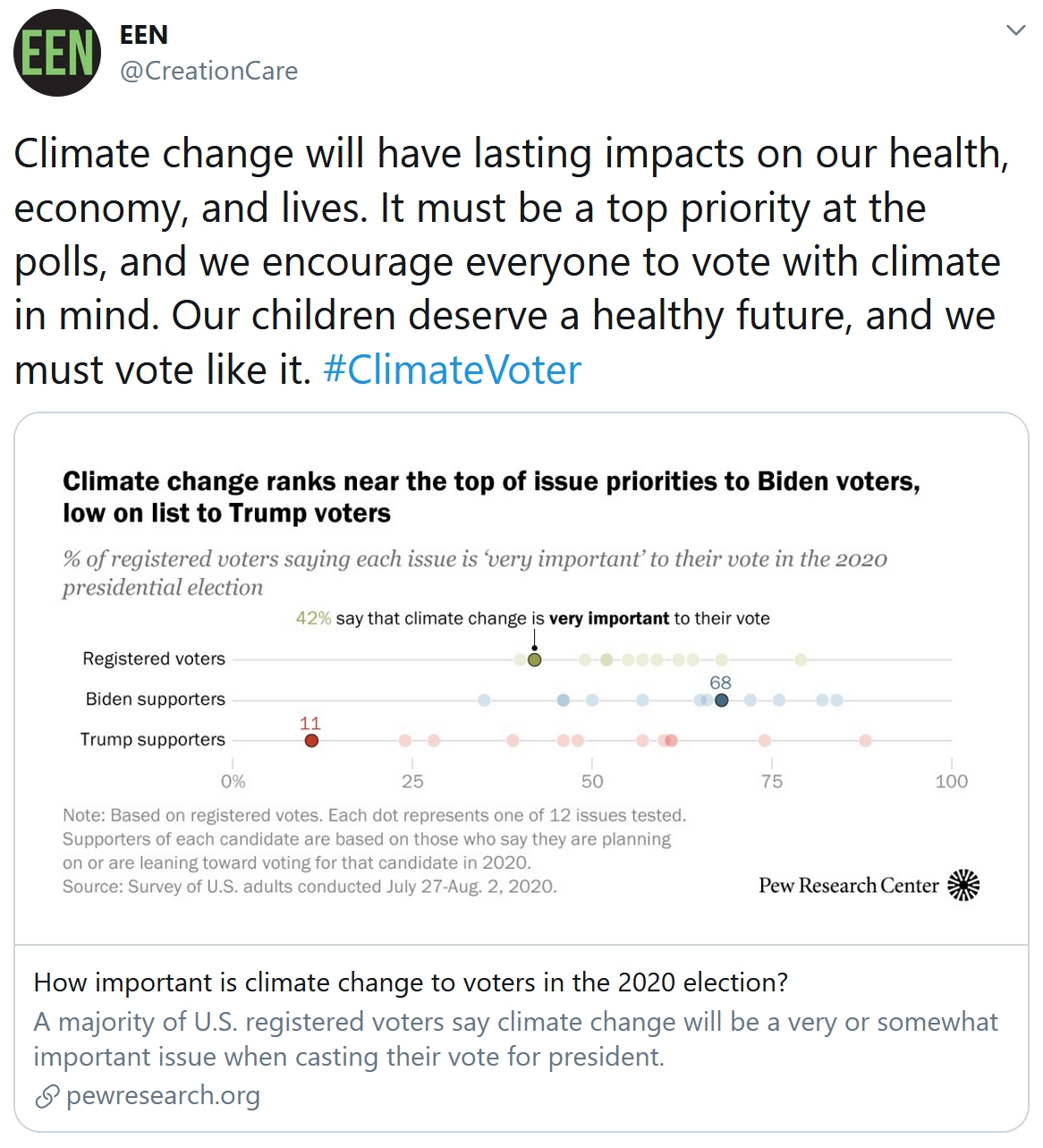
How Important is Climate Change to American Voters in the 2020 Election? Here’s an excerpt from Pew Research Center: “…The issue of climate change has been growing in importance for Americans over time. Six-in-ten adults now view climate change as a major threat to the well-being of the U.S. – up from 44% who said this in 2009. And a January survey – fielded before the coronavirus outbreak – found a rising share citing climate change as a top priority for the president and Congress. In both instances, rising concern has been concentrated among Democrats, but not Republicans. Still, the share of all voters who say climate change will be very important to their vote (42%) trails behind other leading issues such as the economy (79%), health care (68%) and the coronavirus outbreak (62%)...”
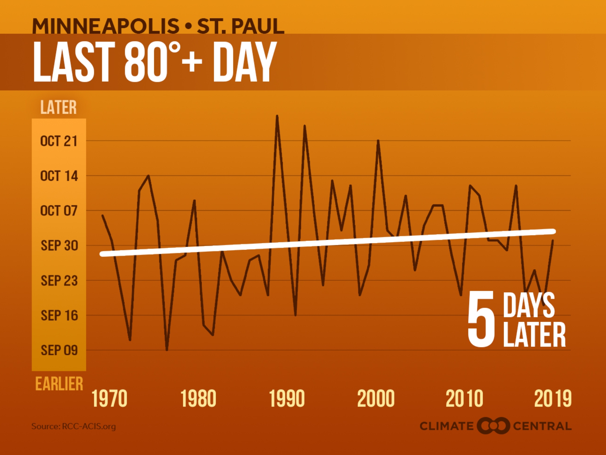
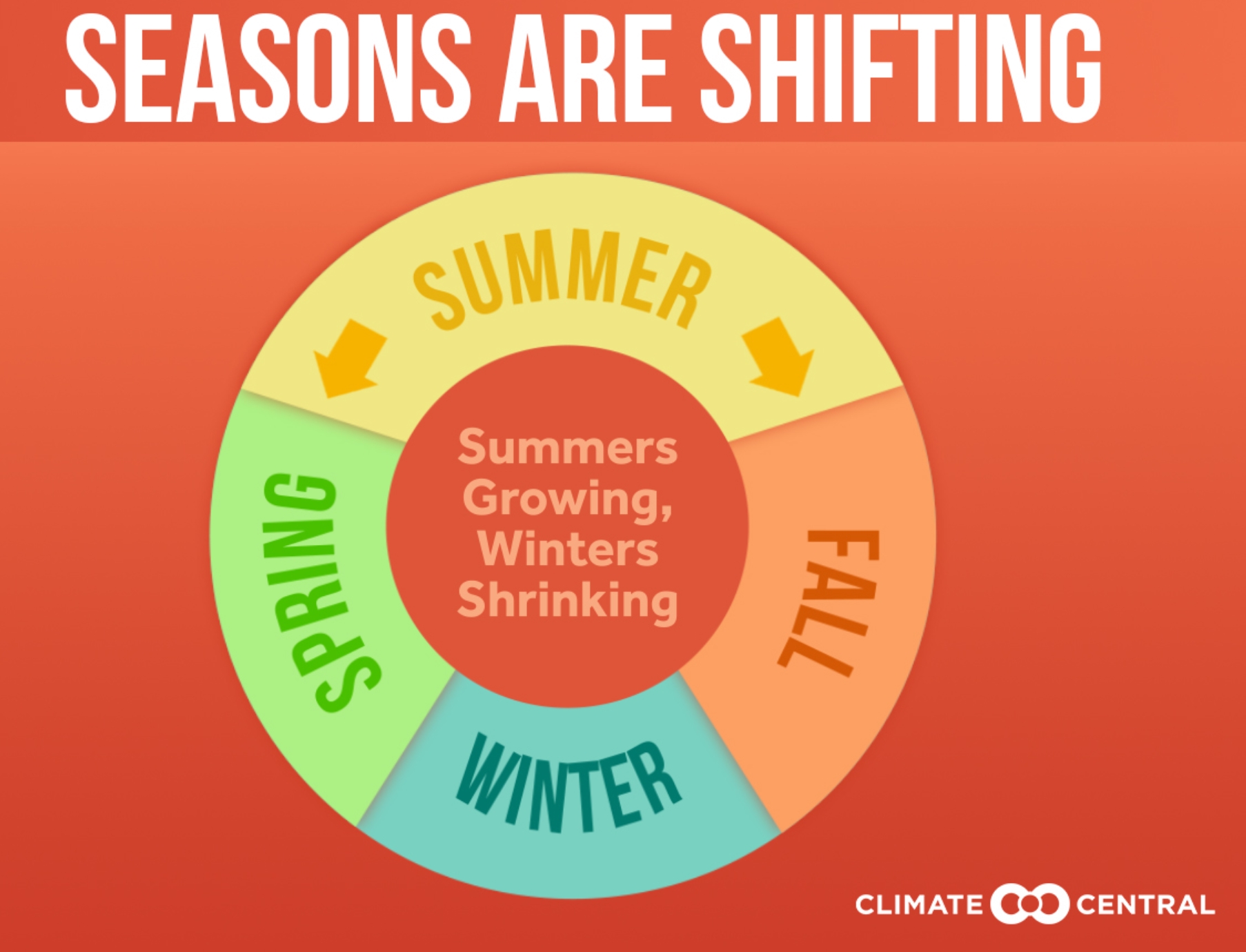
Lingering Summer Warmth. Not every year, but most years summer heat is pushing deeper into traditional autumn, according to an analysis at Climate Central: “A Climate Central analysis found that summer warmth is intruding upon our colder seasons, with 50% (122) of the cities analyzed recording summer temperatures that last a week or more longer than they did 50 years ago. The intrusion of summer warmth into our colder seasons is presenting a challenge for native plant and animal species whose life cycles are scheduled around the once-reliable seasonal changes of the temperate North American climate. Lingering warmth has implications for fall harvests and agriculture. Colder temperatures help to keep many invasive and pest species at bay, so the invasion of summer warmth into our colder seasons could favor crop weeds and pests— potentially resulting in losses for farmers…”
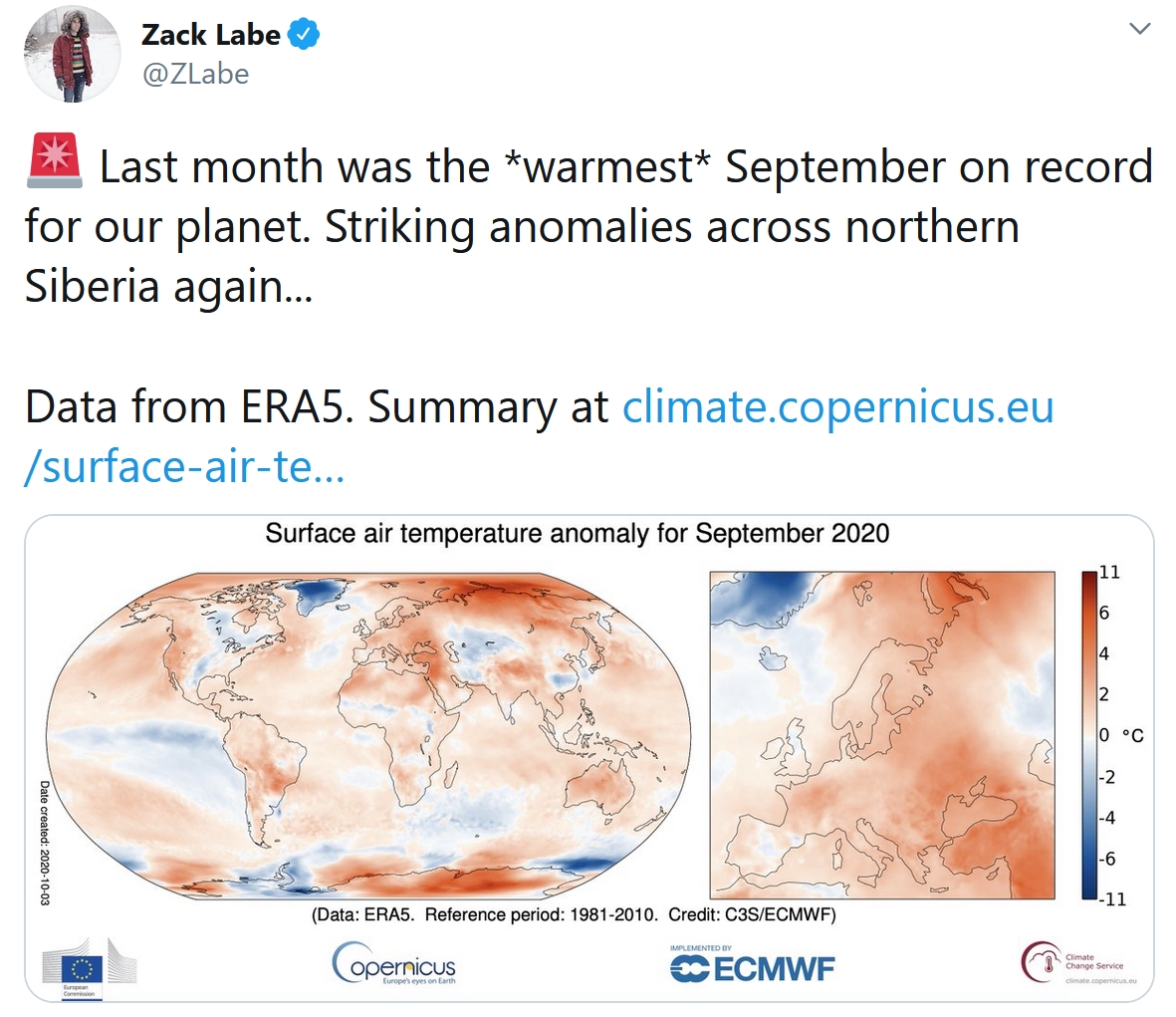
September Was World’s Hottest on Record, EU Climate Change Service Says. Reuters reports: “Last month was the world’s hottest September on record, with unusually high temperatures recorded off Siberia, in the Middle East, and in parts of South America and Australia, the European Union’s Copernicus Climate Change Service said on Wednesday. Extending a long-term warming trend caused by emissions of heat-trapping gases, high temperatures this year have played a major role in disasters from fires in California and the Arctic to floods in Asia, scientists say. Globally, September was 0.05 degrees Celsius warmer than the same month in 2019 and 0.08C warmer than in 2016, previously the warmest and second warmest Septembers on record, the Copernicus data showed...”
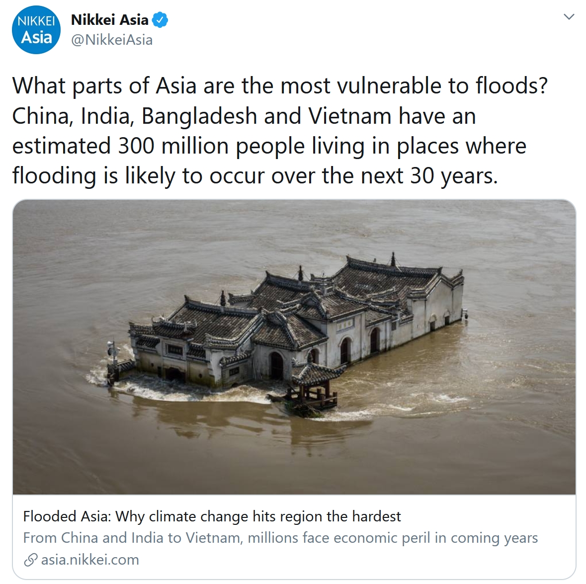
A Third of My Country Was Just Underwater. The World Must Act on Climate Change. Here’s an excerpt of an Op-Ed at The Guardian: “…Like many other climate-vulnerable nations across the globe, Bangladesh is trying to save lives, shore up healthcare systems, and cushion the economic shock for millions of people, all while avoiding fiscal collapse. But this is not a cry for help; it is a warning. For while other countries may be less exposed to the climate crisis, they will not be able to escape its destructive force for long. Countries more fortunate than mine should take a long, hard look at what we are battling. Recent research suggests rising sea levels will force hundreds of millions of people to abandon low-lying coastal cities worldwide by mid-century. Will the global community act in time to avert this catastrophe?…”
Minnesota Town Opts for a Short-Term Approach to its Long-Germ Climate Goals. Energy News Network has the story: “As cities debate ways to meet their long-term goals for emissions reductions, a Minnesota town’s new climate plan calls for fast action and quick results over the next five years. The City Council in Red Wing unanimously approved a five-year climate action plan in August and its members anticipate boosting current programs and starting new initiatives within the next few months. The short time horizon contrasts with climate plans in other cities rolled out over a 20-year span. Red Wing, a historic river town of 16,000 just outside the Twin Cities, is the first community to take advantage of a Great Plains Institute program that creates a five-year window for achieving measurable results on climate change...”
Under Pressure To Act On Climate, JPMorgan Says It Will Push Clients To Cut Pollution: Climate Nexus has headlines and links: “JPMorgan announced Tuesday it will push its clients to reduce their greenhouse gas pollution, following years of pressure from activists over its financing of fossil fuel companies. The bank, the largest in the U.S., said it will create “carbon intensity” metrics to more effectively measure and compare the emissions of its clients based on their output, though what exactly those metrics will include remains to be seen. The bank said it will disclose a preliminary 2030 target next year. The move comes as JPMorgan is under increasing pressure to cut its financing for fossil fuel companies that profit from global warming. In February, it said it would no longer advise or lend to clients that get most of their revenue from coal, but has stopped short of more aggressive action. In May, a shareholder movement seeking a report on the bank’s plans to cut greenhouse gas pollution from companies it lends to failed to achieve a majority by less than a percentage point. “If JPMorgan Chase is serious about aligning with Paris, it must immediately stop financing expansion of fossil fuels and deforestation,” Patrick McCully, the climate and energy director of Rainforest Action Network, told Bloomberg.” (Bloomberg $, Wall Street Journal $, Reuters, FT $, E&E $)
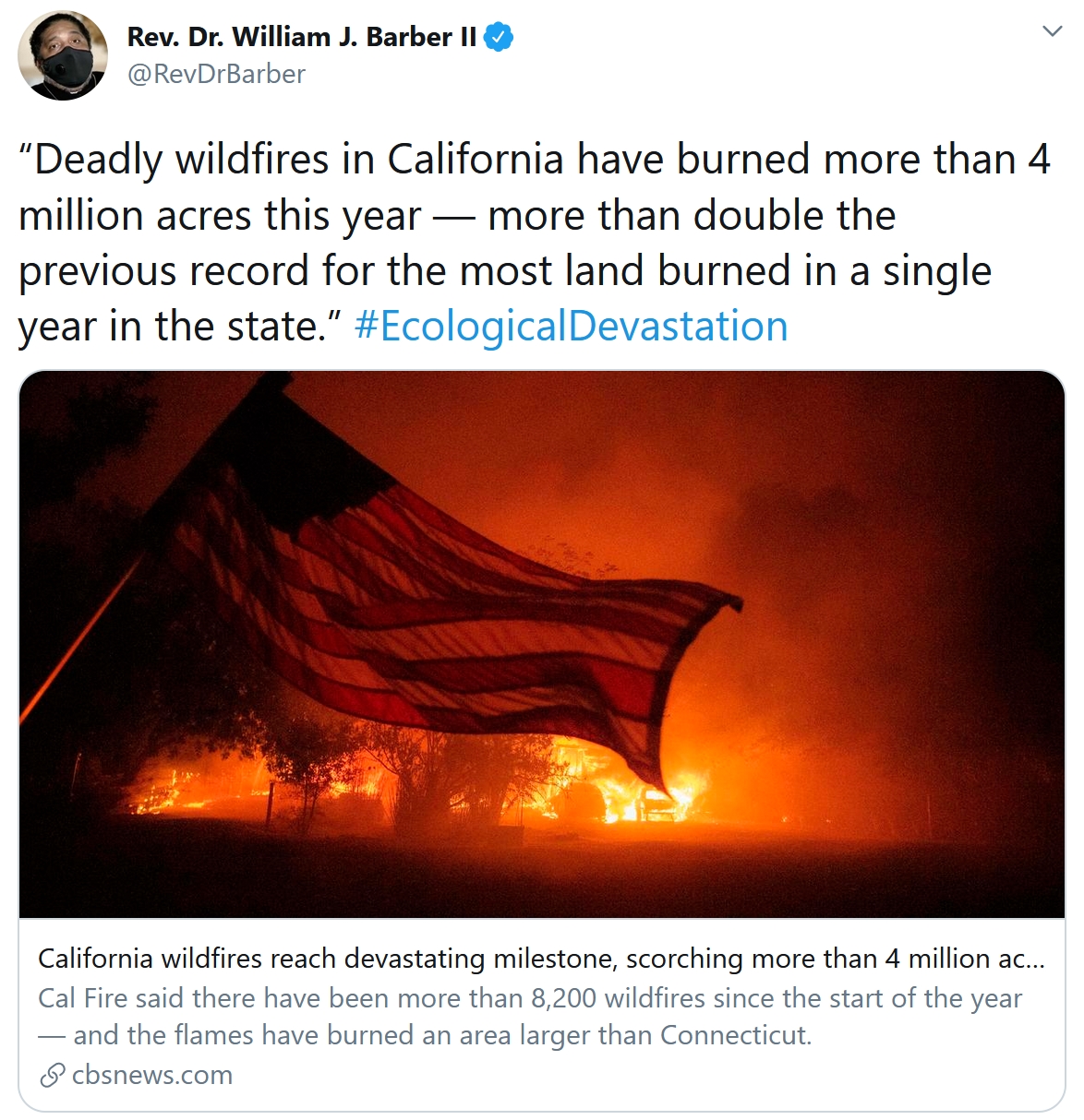
Climate Change is Increasing the Likelihood of Extreme Autumn Wildfire Conditions Across California. Here’s an excerpt of an abstract at IOPscience: “…We show that state-wide increases in autumn temperature (~1 °C) and decreases in autumn precipitation (~30%) over the past four decades have contributed to increases in aggregate fire weather indices (+20%). As a result, the observed frequency of autumn days with extreme (95th percentile) fire weather—which we show are preferentially associated with extreme autumn wildfires—has more than doubled in California since the early 1980s. We further find an increase in the climate model-estimated probability of these extreme autumn conditions since ~1950, including a long-term trend toward increased same-season co-occurrence of extreme fire weather conditions in northern and southern California. Our climate model analyses suggest that continued climate change will further amplify the number of days with extreme fire weather by the end of this century, though a pathway consistent with the UN Paris commitments would substantially curb that increase…”
Three Scenarios for the Future of Climate Change. Elizabeth Kolbert writes for The New Yorker: “…In a third scenario, global warming could by 2050 produce global conflict that draws in poor nations and rich ones alike. This, too, already seems, to a certain extent, to be taking place. A significant body of research suggests that the Syrian civil war was caused, at least in part, by a drought that pushed more than a million people out of their villages. The war, which has claimed some four hundred thousand lives, has, in the course of nearly a decade of bloodshed, involved the U.S., Russia, Saudi Arabia, Iran, and Turkey. Future droughts in the Middle East are apt to be even more severe and prolonged, as are droughts in other volatile regions, like the Horn of Africa. It doesn’t seem that it would take too many more Syrian-scale conflicts to destabilize large swaths of the globe...”
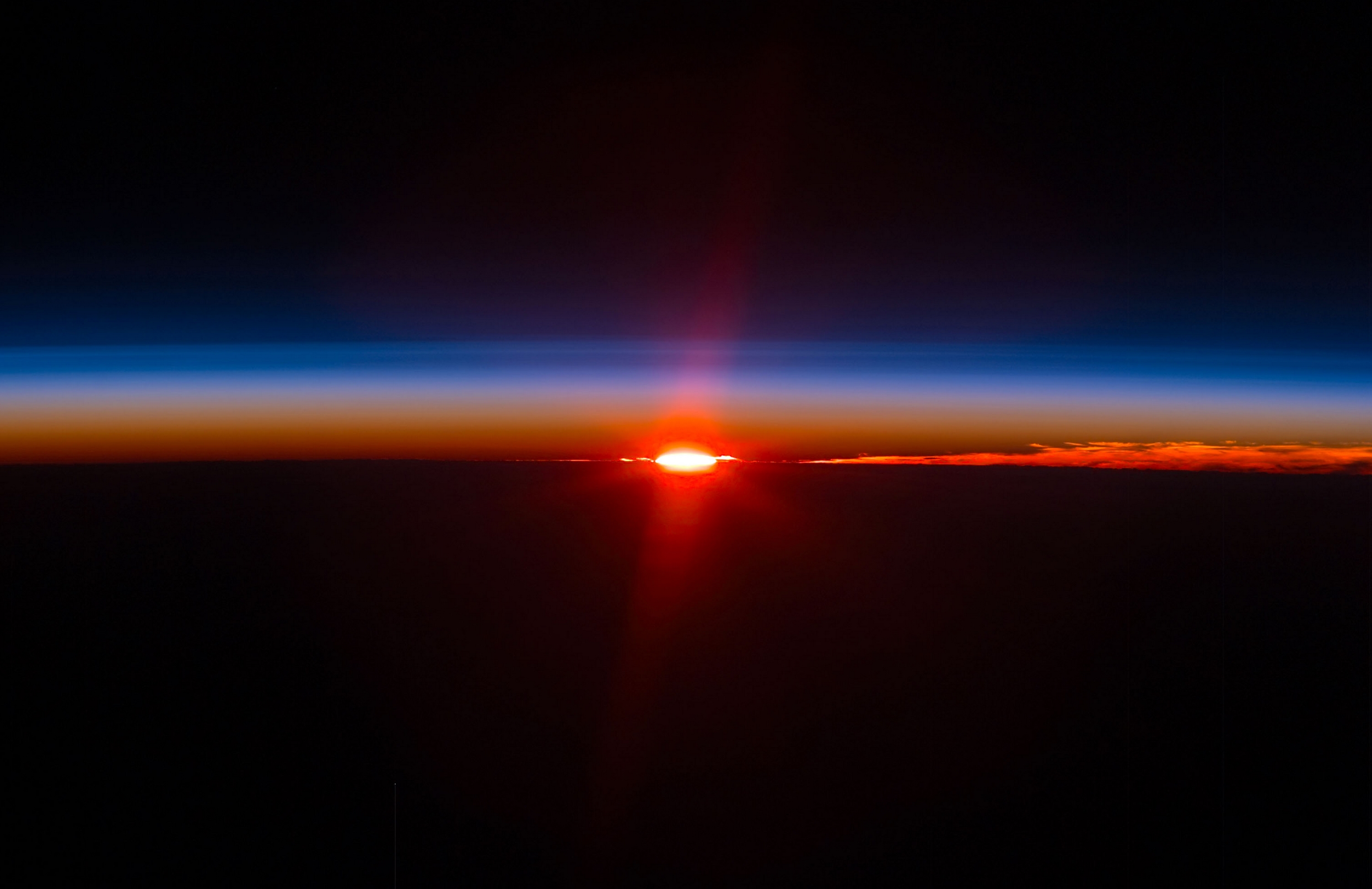
Photo credit: Scott Kelly, NASA ISS.
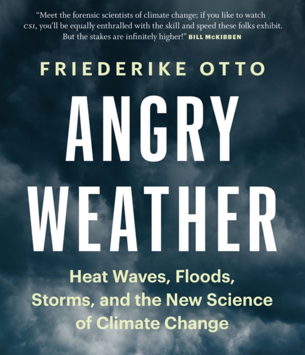
Supercomputers, Simulations and the New Science of Extreme Weather Attribution. How much is natural, how much of the extremes are flavored by a warmer, more volatile climate? A story at Yahoo Finance caught my eye: “...In the past, climate scientists have been hesitant to say any particular weather event, no matter how wild, was due to the effects of global warming, greenhouse gases, and other human causes. But Dr. Friederike Otto and the World Weather Attribution team studied Harvey and determined that climate change made the rainfall more intense, causing between 12% and 22% more water to drop on Houston and its surrounding area. It’s a relatively new science, determining “whether and to what extent anthropogenic — so human-induced — climate change alters the likelihood and intensity of extreme weather events,” Otto told Digital Trends. In her new book, Angry Weather: Heat Waves, Floods, Storms, and the New Science of Climate Change, she explains how the World Weather Attribution project began and how its attribution reports can be used to help people sue greenhouse gas emitters…”