
Working Up a Minor Sweat in November
Yesterday was a confusing but deleriously happy glimpse of weather at its finest. Walking the dog in a T-shirt and shorts, flicking on the A/C with Christmas music playing in the house. A complete and wildly-welcome disconnect from reality.
(Paul checks notes)
Remember, 29 years ago on this date we were digging out from 28 inches of snow in the Twin Cities, all of us gob-smacked by a 3-day Halloween Superstorm of 1991.
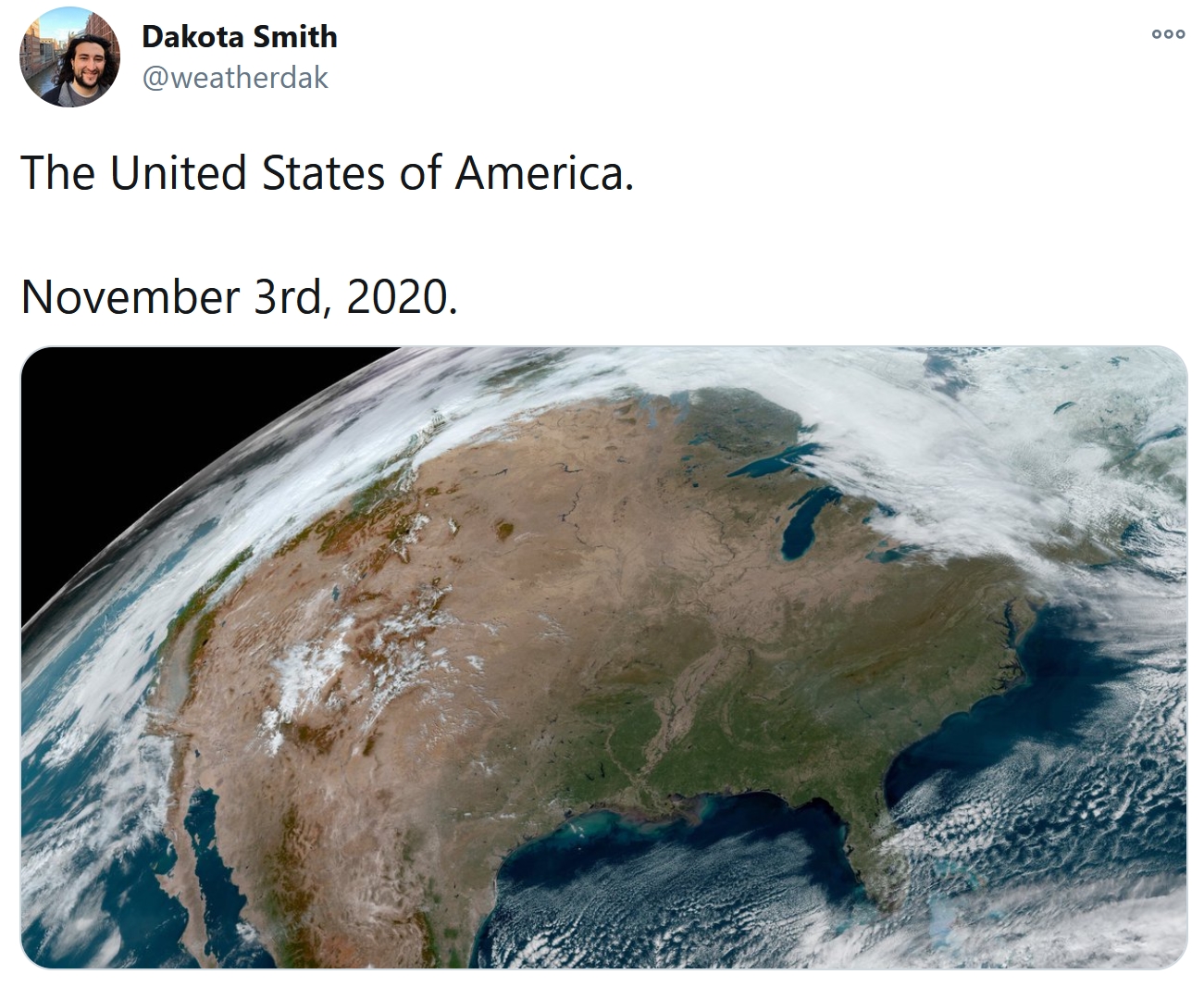
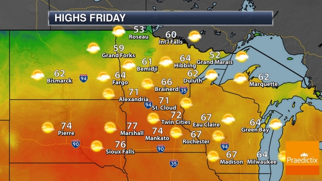
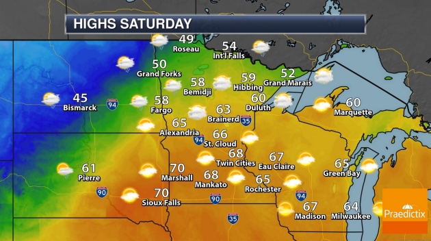
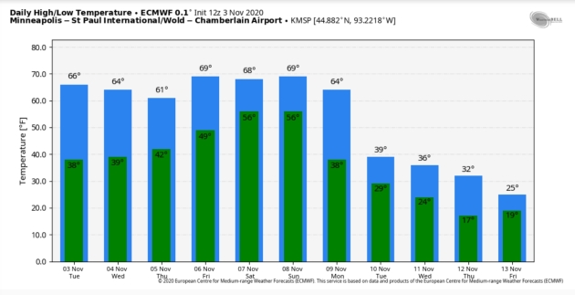
If you slept through the second warmest Election Day on record you’ll get 4 more perfect days to squeeze in walks, bike rides, outdoor lunches – or last-minute yardwork and fieldwork. Unseasonably mild weather lingers into Sunday with afternoon readings in the 60s; another shot at 70F Friday and Saturday. Wow.
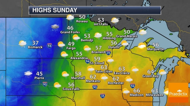
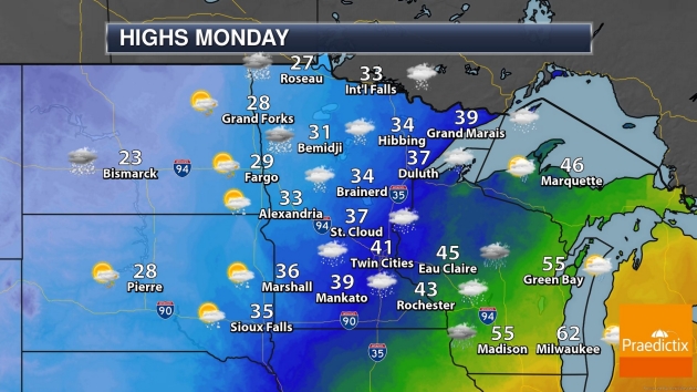
A thundershower may sprout late Sunday and next week brings 30s, even a rain-snow mix by Tuesday. Details pending.
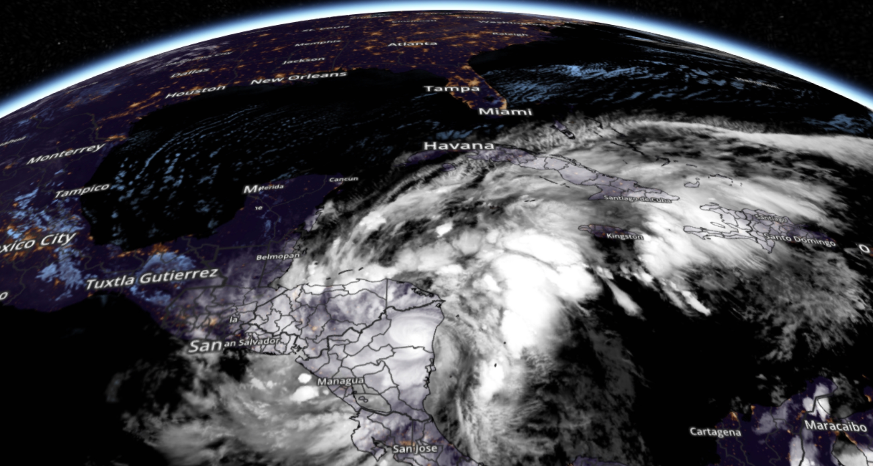
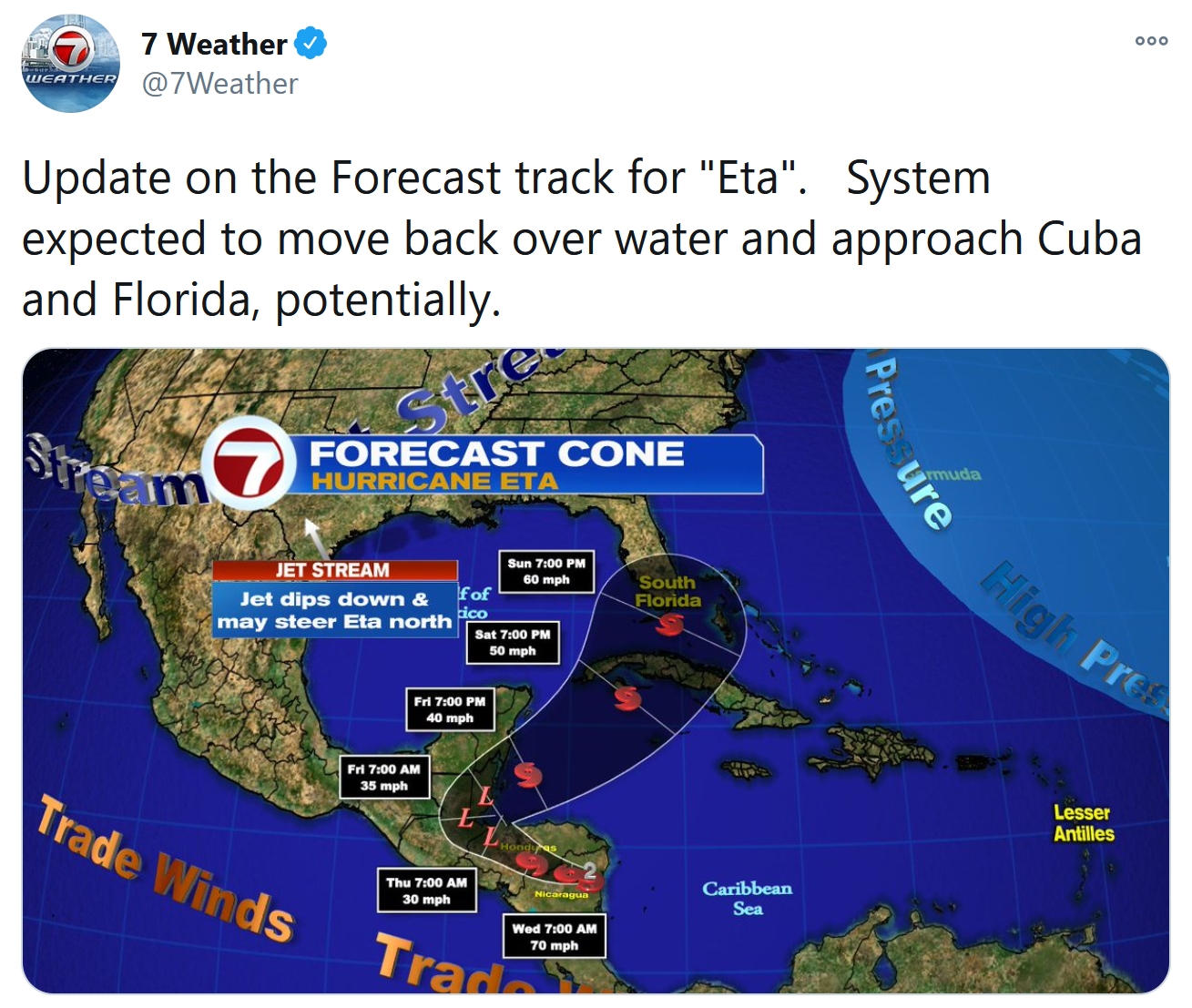
Remind me not to complain. After battering Nicaragua as a Category 4 storm, “Eta” is forecast to push north, possibly impacting Florida late Saturday into Monday. Gulp.
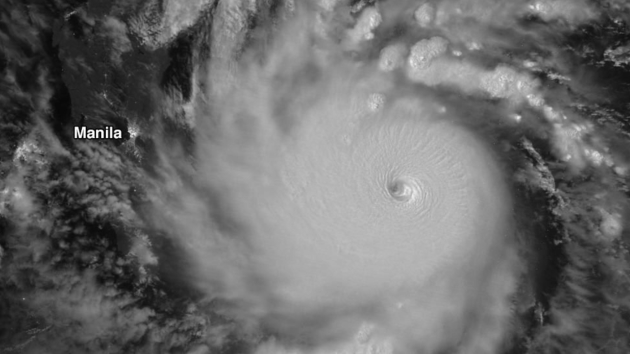
Super Typhoon Goni Slams into Philippines as Strongest Landfalling Tropical Cyclone on Record. Dr. Jeff Masters has eye-opening statistics about the mega-hurricane that just hit the Philippines at Yale Climate Connections: “…Goni was the strongest landfalling tropical cyclone in world recorded history, using one-minute average wind speeds from the National Hurricane Center for the Atlantic/northeast Pacific and one-minute average winds from JTWC for the rest of the planet’s ocean basins. The previous record was jointly held by Super Typhoon Meranti, which made landfall on September 16, 2016, on Itbayat Island, Philippines, and Super Typhoon Haiyan, which made landfall on November 8, 2013, on Leyte Island, Philippines. Both had maximum winds of 195 mph at their peak intensity, but made landfall with 190 mph winds, according to JWTC. There are no official world records for strongest landfalling storms, since the JTWC does not routinely assign landfall intensities in their post-season summaries (though they did make an exception for Super Typhoon Haiyan)…”
Image credit: “Super Typhoon Goni as seen by the light of the Halloween full moon on October 31, 2020, by the VIIRS instrument. The lights of Manila are visible at left.” (Image credit: NASA Worldview).
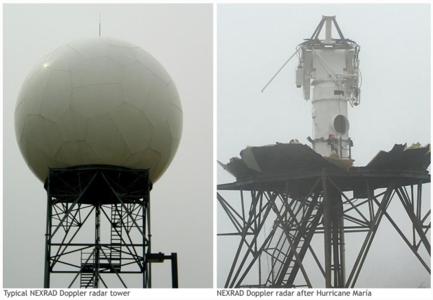
More Durable Radars Are Needed For an Era of Stronger Hurricanes. Dr. Marshall Shepherd reports for Forbes: “…According to University of Miami hurricane expert Brian Mcnoldy, Hurricane Zeta marked the fifth landfall during the state, three of which were hurricanes. In August, Hurricane Laura (2020) knocked out the National Weather Service radar at its Lake Charles office. Unfortunately, the same region faced threats from Hurricanes Delta (2020) and Zeta (2020), respectively, after Laura. As I sit at my computer tracking an unprecedented Hurricane Eta (yep, Eta), strong and rapidly intensifying storms in recent years raises the following question for me: Do we need more durable weather radar infrastructure for an era of stronger hurricanes?…”
Image credit: “NEXRAD Doppler radar in Puerto Rico after Hurricane Maria.” NOAA Climate.gov.
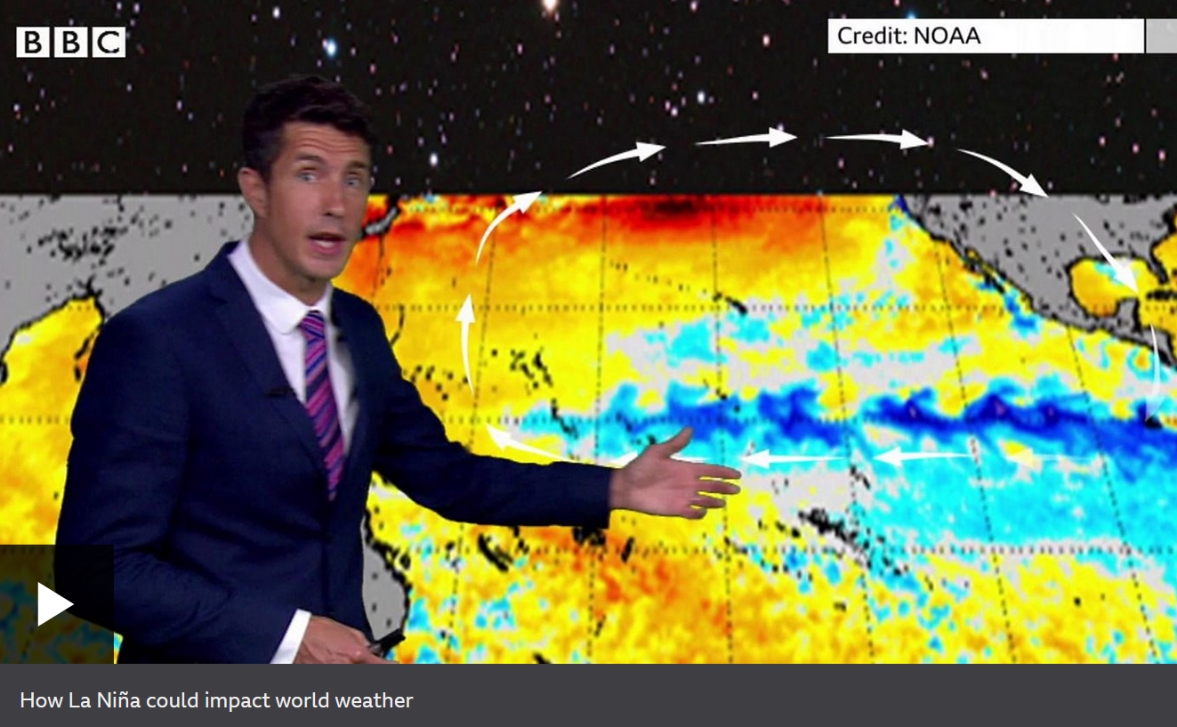
Moderate to Strong La Nina Event Develops in the Pacific. BBC News has an update: “…There is a 55% chance of the conditions persisting through the first quarter of next year. While a La Niña event normally exerts a cooling influence on the world, this is unlikely to make too much of a difference to 2020. “La Niña typically has a cooling effect on global temperatures, but this is more than offset by the heat trapped in our atmosphere by greenhouse gases,” said Prof Petteri Taalas, from the WMO. “Therefore, 2020 remains on track to be one of the warmest years on record and 2016-2020 is expected to be the warmest five-year period on record,” he said “La Niña years now are warmer even than years with strong El Niño events of the past...”
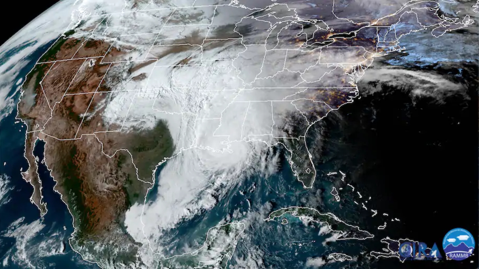
How the Oklahoma Ice Storm Helped Strengthen Hurricane Zeta Beyond Expectations. Here’s an excerpt of a good explainer from Capital Weather Gang: “…The hurricane managed to capitalize on upper-level winds streaming through Texas and Oklahoma generated by an unusually sharp dip in the jet stream for late October. This dip allowed record cold to crash through the northern Rockies and into the Plains, with temperatures up to 60 degrees colder than average and as low as minus-33 degrees. The upper level winds roaring from south to north along the eastern flank of the jet stream dip facilitated diverging air flow above and out ahead of the hurricane. This encouraged air to rise, cool and condense into clouds and precipitation, and led to an increase in thunderstorm intensity within Hurricane Zeta, which overwhelmed anything that might inhibit it...”
Image credit: “Visible satellite image from Wednesday showing Hurricane Zeta moving ashore in Louisiana, an ongoing ice storm over Texas and Okla., and smoke plumes from fires in Southern California.” (CIRA/RAMMB)
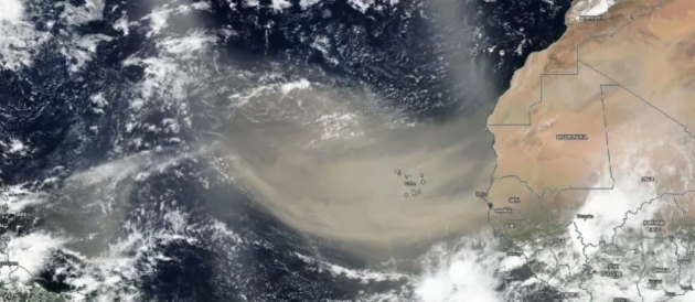
How African Dust Storms Create Caribbean Beaches. Mental Floss has a fascinating post; here’s the intro: “The fertile red soils of Bermuda and the rich coral reefs of the Bahamas are a geological mystery. Both are made up of a specific combination of alien minerals and nutrients not found anywhere on the islands or in the ocean that surrounds them. Scientifically speaking, they should not exist. But over the last decade, geologists have come up with an explanation for these ecological anomalies: They originated 5000 miles away in Africa. For more than a million years, dust from the Sahara Desert has hitched a ride on westward-traveling winds to the Caribbean. Bermuda and the Bahamas are, quite literally, an extension of the world’s largest desert…”
Image credit: “On June 18, 2020, NASA-NOAA’s Suomi NPP satellite captured this visible image of the large light brown plume of Saharan dust over the North Atlantic Ocean.” NASA Worldview // Public Domain.

Hot or Cold: Weather Alone Has No Significant Effect on COVID-10 Spread. ScienceDaily has the report: “…Research led by The University of Texas at Austin is adding some clarity on weather’s role in COVID-19 infection, with a new study finding that temperature and humidity do not play a significant role in coronavirus spread. That means whether it’s hot or cold outside, the transmission of COVID-19 from one person to the next depends almost entirely on human behavior. “The effect of weather is low and other features such as mobility have more impact than weather,” said Dev Niyogi, a professor at UT Austin’s Jackson School of Geosciences and Cockrell School of Engineering who led the research. “In terms of relative importance, weather is one of the last parameters…”
File image: CDC.

Couple Gets Married at Dunkin Donuts Drive-Thru, Where They Met. Because why not. CNN.com has the story: “A couple who met at a Dunkin’ drive-thru three years ago got married at the same window where they first met, surrounded by friends, family and many, many donuts. As the general manager of a Dunkin’ in Oklahoma City, Sugar Good is used to seeing hundreds of new faces a day. But there was one face in particular she just couldn’t get out of her head. His name was John Thompson, and she memorized the time he would visit every morning, the details of his order — a large hot coffee with cream and sugar and a sausage, egg and cheese sandwich. But most of all, she memorized his smile...”
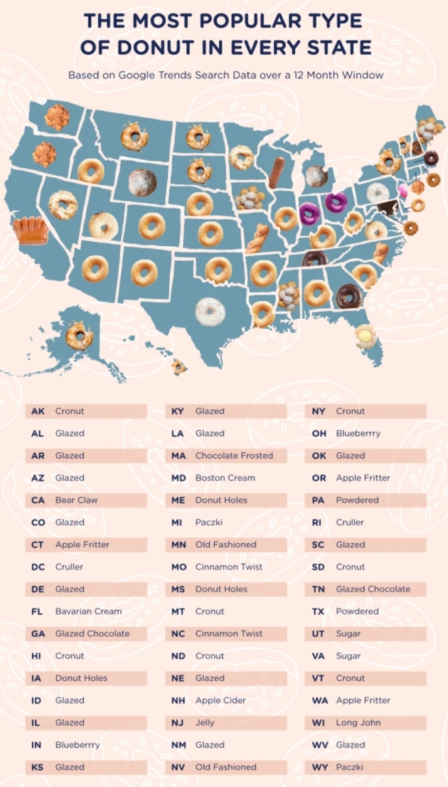
Each State’s Favorite Donut, Mapped. Yeah, we have a theme going on. Glazed donuts are a coping skill, OK? No guilt here, not in 2020. Mental Floss has a timely expose: “Earlier this month, Dunkin’ unveiled the Spicy Ghost Pepper Donut, a picante pastry that piqued the interest of culinary daredevils across the nation. But for every brave soul eager to try it out, there were plenty of other Dunkin’ customers whose eyes never strayed from the basket of sweet, reliable glazed doughnuts. It’s hard to overstate the popularity of the glazed doughnut. Data crunchers at The Waycroft, a luxury apartment complex in Arlington, Virginia, analyzed Google Trends searches from the last 12 months and found that it’s the apparent doughnut of choice in a staggering 15 states...”
Map credit: “This map would make for quite an eclectic box of assorted doughnuts.” The Waycroft.

Wrong Way to Transport a Snowmobile: Exhibit A. Bring Me The News has the rather unusual story: “Snowmobiling season is right around the corner, but transporting a snowmobile on top of a car is not the way to get the recreational vehicle where you want it to be. One Minnesota motorist driving a Toyota Corolla found that out the hard way. According to the Wisconsin Department of Transportation, someone driving the small red car had a Polaris snowmobile strapped to the top of the car, with the skis of the snowmobile sticking out horizontally over the left side of the car…”
Photo credit: Wisconsin DOT.
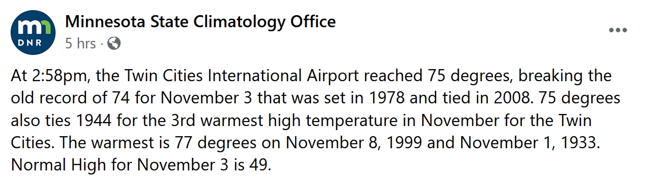
75 F. record high in the Twin Cities on Tuesday.
49 F. average high on November 3.
45 F. high on November 3, 2019.
November 4, 1982: 20 inches of snow falls in the Kabatogema area.
November 4, 1901: With a high temperature of only 22 and a low of 15, 175 boxcars of potatoes are in peril at the Minneapolis rail yard. Workers scrambled to move the rail cars full of tubers in roundhouses and transfer potatoes to refrigerated cars. Individual stoves had to be purchased on the spot for 59 remaining cars. Thankfully, most of the spuds were saved.
November 4, 1853: A cold snap begins at Ft. Snelling. The next four days would be 16 degrees or lower.
November 4, 1727: The first outdoor celebration at the chapel of Fort Beauharnois on Lake Pepin is postponed due to ‘variableness of the weather.’

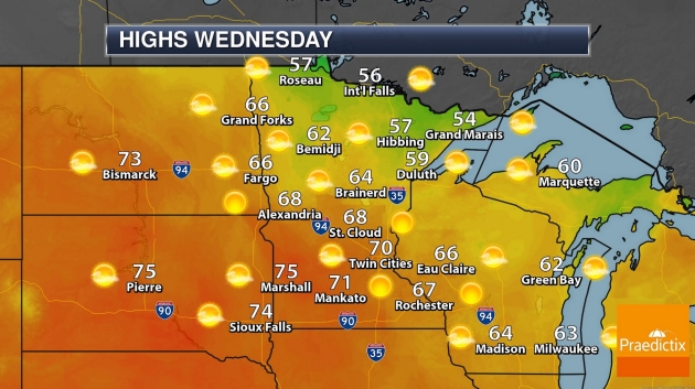
WEDNESDAY: Sunny and pleasant. Winds: SW 7-12. High: 74
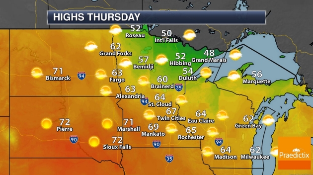
THURSDAY: Blue sky, a bit cooler. Still perfect. Winds: W 5-10. Wake-up: 45. High: 68
FRIDAY: Sunny, breezy and milder. Winds: S 10-20. Wake-up: 50. High: 72
SATURDAY: Partly sunny, windy, still balmy. Winds: S 15-25. Wake-up: 55. High: near 70
SUNDAY: Fading sun, humid with a late-day T-shower. Winds: S 15-35. Wake-up: 57. High: 66
MONDAY: Windy and cooler. Few showers. Winds: NW 10-20. Wake-up: 46. High: 52 (falling)
TUESDAY: Sloppy mix of rain and snow possible. Winds: NE 10-20. Wake-up: 32. High: 38