
While California has seen dramatic improvement in drought conditions over the past few months, Florida has experienced the opposite. At the start of the year, 43% of the state was under some sort of drought classification by the U.S. Drought Monitor. Since then, below normal precipitation for many locations and widespread warmer than normal temperatures have allowed the drought to expand, with 88% of the state now under abnormally dry, moderate, or severe drought. The worst conditions have shifted from the Panhandle to the southwestern part of the state over the past couple months.

The map on the left shows the U.S. Drought Monitor as of March 21. The map on the right shows the Drought Monitor on January 3.
The abnormally dry start to the year for much of the state has allowed drought conditions to expand. Orlando, which is under a moderate drought, is running nearly 5 inches below normal for precipitation to date and is currently experiencing its 4th driest start to the year on record. Only 0.24” of rain has fallen at Key West since January 1, which is the driest start to the year on record for that location. Melbourne, Fort Myers, Tampa, and Jacksonville are all running 2-5” below normal for precipitation so far this year. Portions of the Panhandle and extreme southeast Florida have seen near or slightly above normal precipitation since the beginning of the year, and drought conditions are generally less severe in these areas. The maps below show precipitation since January 1 and departure from normal.


It has also been a very warm start to the year for much of the state. Key West, Miami, Fort Lauderdale, Tampa and Melbourne are all experiencing their warmest start to the year on record. Numerous record highs have been set across the state since the start of the year. Fort Myers (8), Tallahassee (11), West Palm Beach (6), and Jacksonville (12), have all set numerous high temperature records over the past 90 days. (For comparison, Jacksonville only set 8 high temperature records in all of 2022).

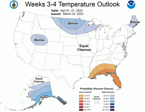
Much of the state received above normal precipitation during the 2022 hurricane season, which has helped prevent more severe drought conditions from developing. In addition, winter droughts are not uncommon in Florida, and conditions often improve once the rainy season begins. The Climate Prediction Center precipitation outlook for the next few weeks shows chances for above normal precipitation across the state, while temperatures are generally expected to remain at or above average through April.

Who is Praedictix? We are a weather company that focuses on delivering credible weather forecasts to our clients. We have three main offerings: media, weather graphics, and weather consulting.
Media: With two HD studios, we’re able to create professional weather forecast videos for use in television, social media, apps, and websites. Our forecasts are tailored to our clients’ brand. Our content ranges from national to hyperlocal forecasts and air all over the country.
Weather Graphics: We have access to a robust weather dataset which allows us to create high customizable, HD weather maps and graphics for use in television, digital signage, social media, and websites. Our white-label graphics allow our clients to push their own brands and sponsors.
Consulting: We lend our weather expertise to our clients to help with risk mitigation and business optimization by way of conference calls, emails, and briefings. We also have a forensic meteorology team that specializes in forensic weather analysis and expert testimony.
Click right HERE to learn more about us or contact us for your weather needs.
Thanks for checking in and have a great day!
Eli Flicker