
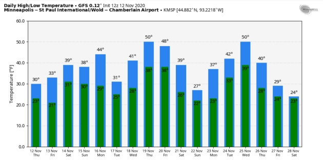
The Perils of Snow Squalls and a Thanksgiving Thaw
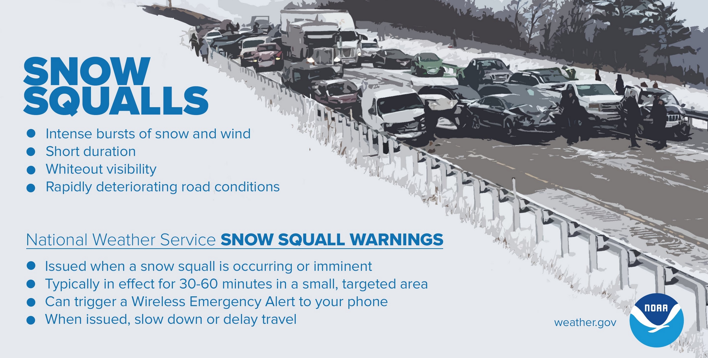
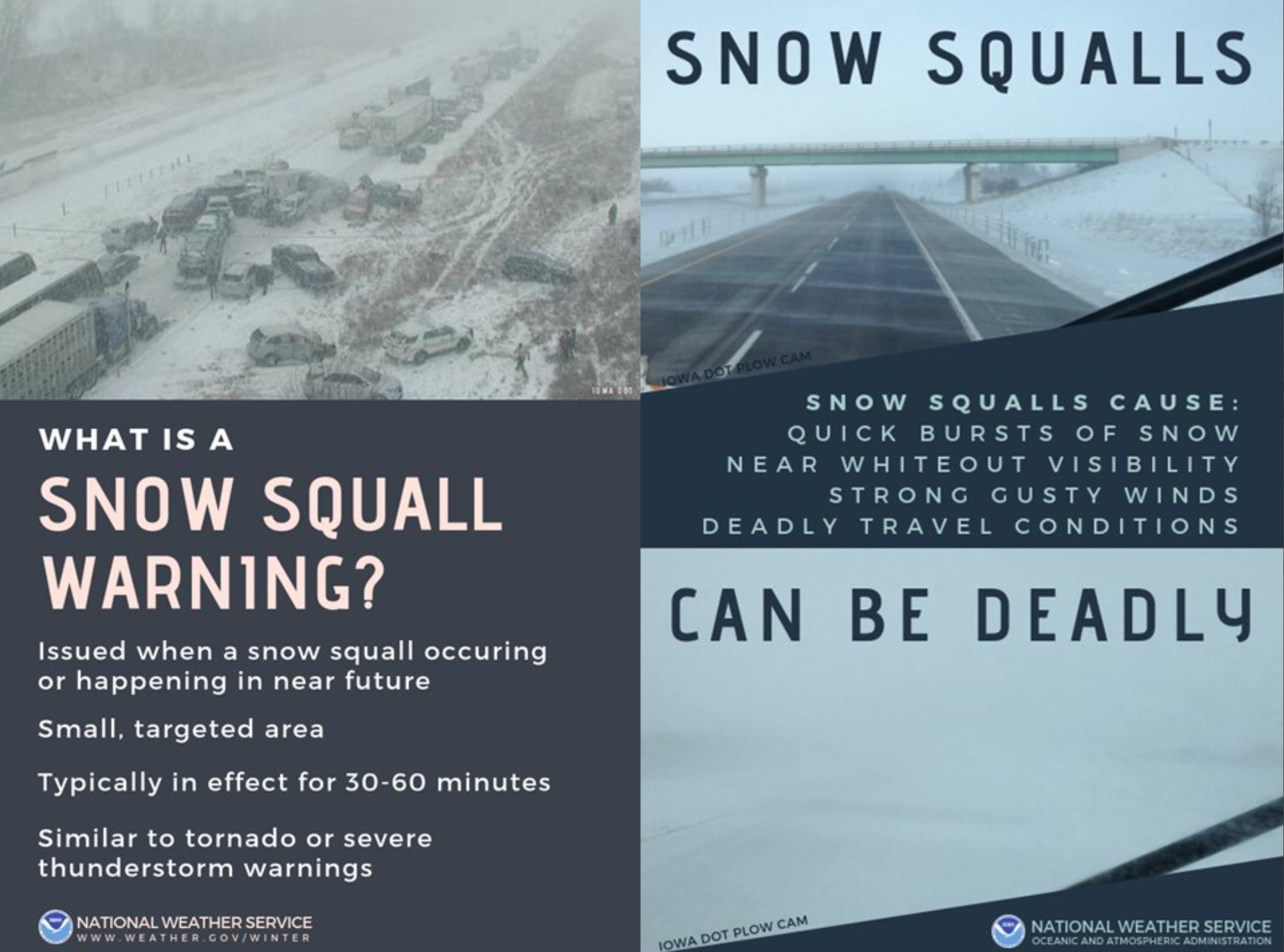
Many of us become transfixed by the big snowstorms but sometimes it’s the little things. Like yesterday’s 60-minute snow burst, a “snow squall”. Prevalent downwind of the Great Lakes, these bands of torrential snow are similar to a line of summer thunderstorms: a narrow band of intense precipitation. Visibilities can fall to zero in seconds, creating mayhem on the highways.
What I’ve found over the years (the hard way) is that it’s not “how many inches” of snow falls. It’s the timing, intensity and temperature of the roadway surface. A lousy inch, at the wrong time, with temperatures in the
20s, can be just as disruptive as a half foot of snow on a normal winter day.
No big storms are expected between now and Thanksgiving. A little light rain or drizzle is possible Saturday, but next week looks dry with mellowing temperatures. A run of 40s is likely; both ECMWF and NOAA’s GFS weather model hint at a shot at 50F.
Get out and play in the snow – much of it will be gone within a week.
PS: we’ll make more.
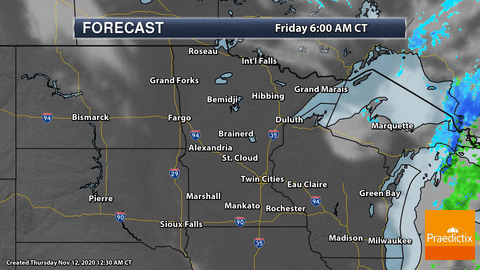


Praedictix Briefing: Issued Thursday morning, November 12th, 2020:
Latest On Eta
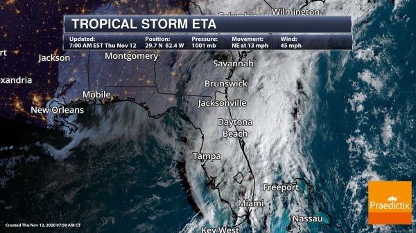
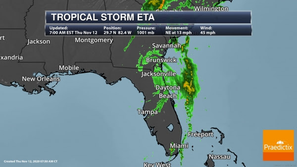
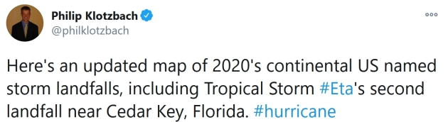
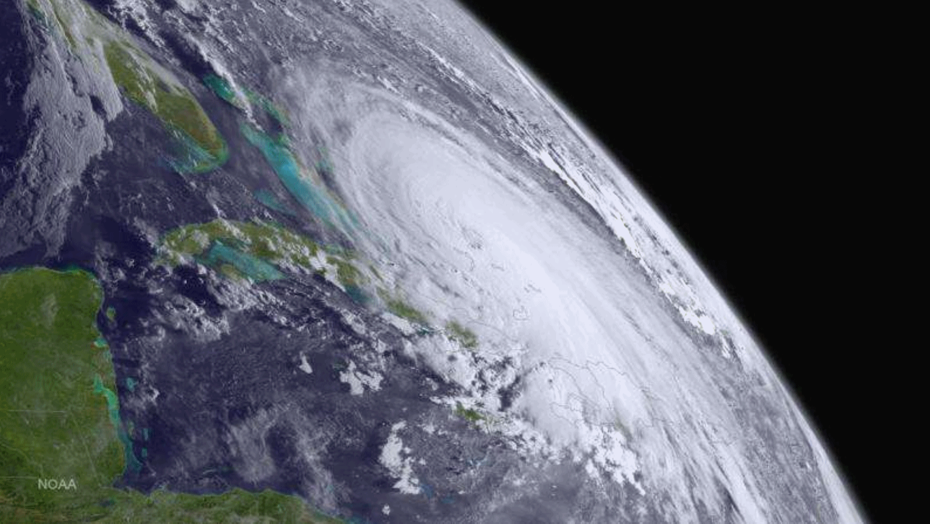
Eta Inland Over Florida. Eta made landfall near Cedar Key, FL, at 4 AM ET this morning. Since then, Eta has continued to move inland, producing heavy rain and gusty winds. As of the 7 AM ET update, the center of Eta was located about 10 miles west of Gainesville, FL, or 60 miles southwest of Jacksonville, FL, and moving northeast at 13 mph. Eta had sustained winds of 45 mph. Tropical-storm-force winds extend outward to 115 mph, but most of that is out over water to the east of the center of the storm. Recently a station at St. Augustine had a wind gust of 44 mph.
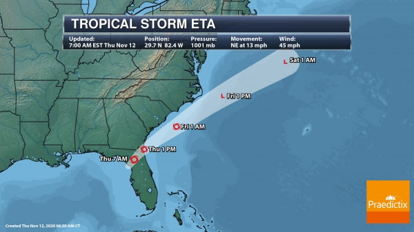
Eta Track. Eta will continue to move northeast over the next few days, accelerating as it does so. This should bring Eta across northern Florida into the western Atlantic as we head toward the afternoon hours, and then parallel the Carolinas as it continues to head out to sea. We should see Eta continue to weaken over the next day or so before becoming a non-tropical low on Friday when some restrengthening could occur.
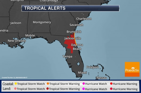
Tropical Storm Warnings. Tropical Storm Warnings continue this morning across portions of northern Florida and far southeastern Georgia in association with Eta due to the potential of tropical-storm-force winds across the region. These will likely expire later today as Eta moves out into the Atlantic.
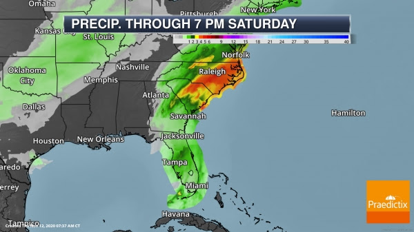

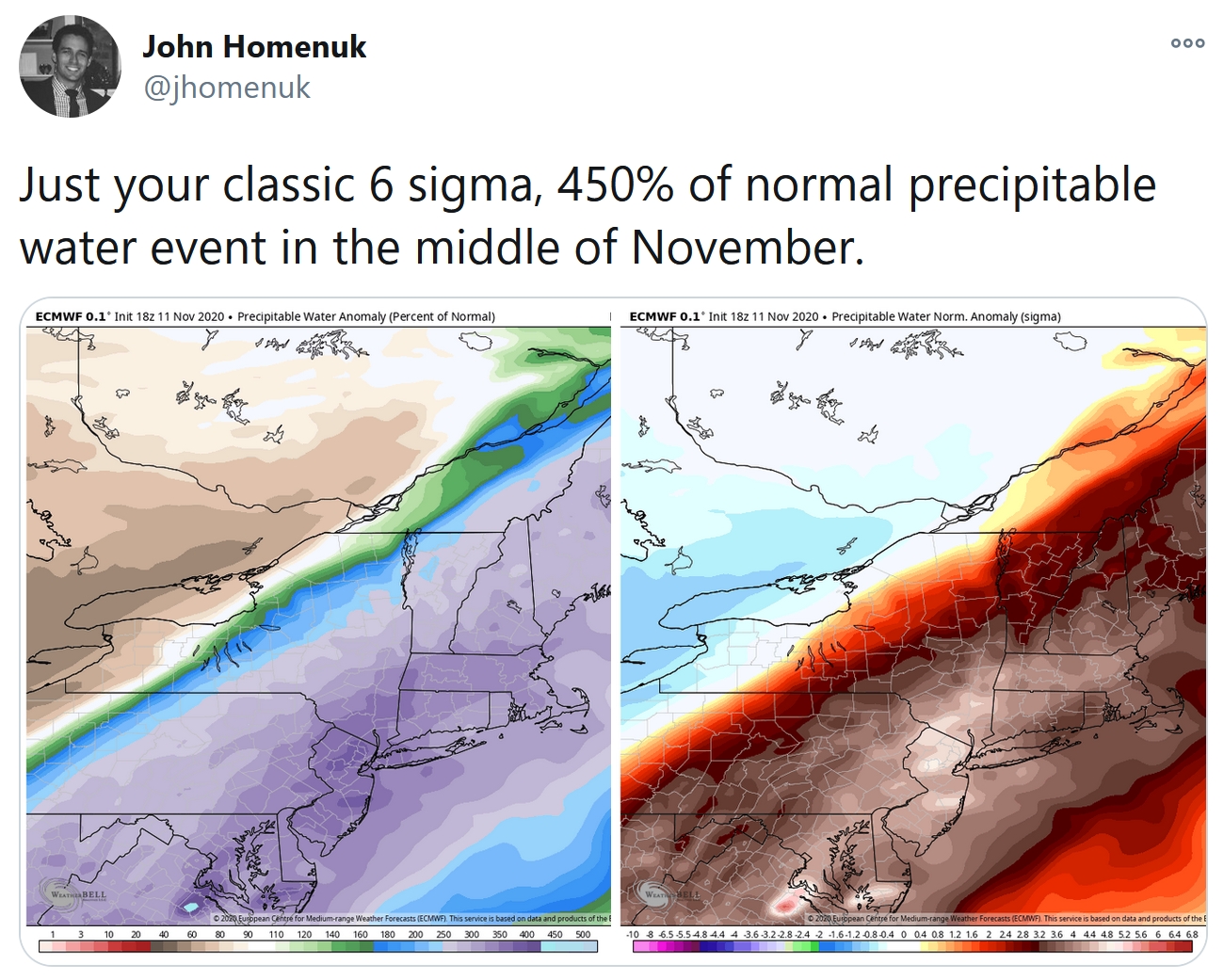
Heavy Rain And Flooding. Heavy rain will continue across the Mid-Atlantic and Southeast today into Friday due to tropical moisture streaming northward ahead of Eta combining with a cold front moving through the region. Overall, 2-8” of rain could fall across the region, with the potential of 2-3” per hour rates. This is likely to cause flash flooding across the region, some of which could be significant and life-threatening.
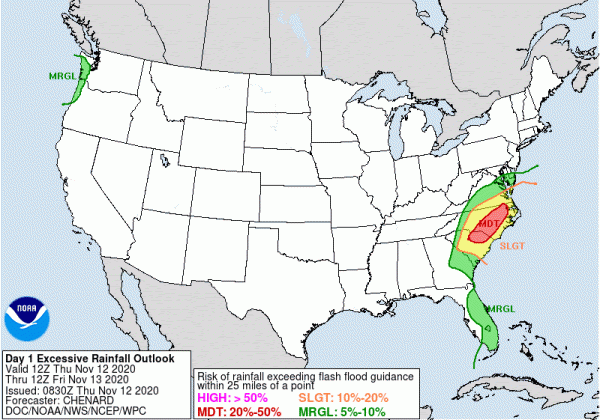
Moderate Flood Risk. Due to the heavy rain across the Carolinas today, a Moderate Risk of flash flooding is in place.
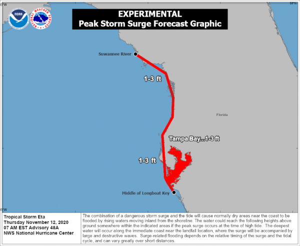
Storm Surge Concerns. We will continue to see some elevated water levels along the western Florida coast today which will gradually decrease today. The water could reach the following levels today, however: Suwannee River to Middle of Longboat Key, FL including Tampa Bay…1-3 feet.
Other Atlantic Concerns
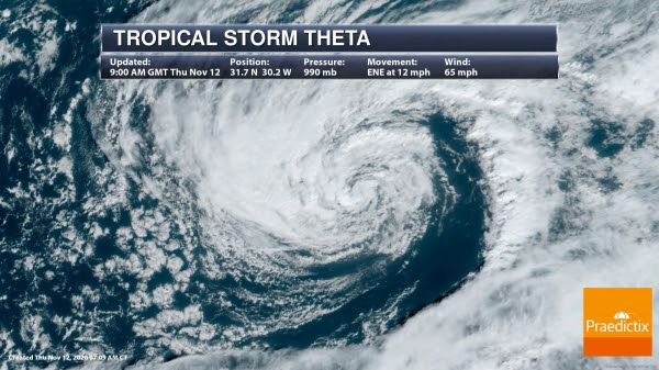
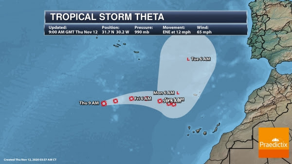
Tropical Storm Theta. Theta will continue to move east-northeast and not pose a threat to land over the next several days. We should see Theta weaken as we head toward the weekend and the storm eventually turns north-northeast.
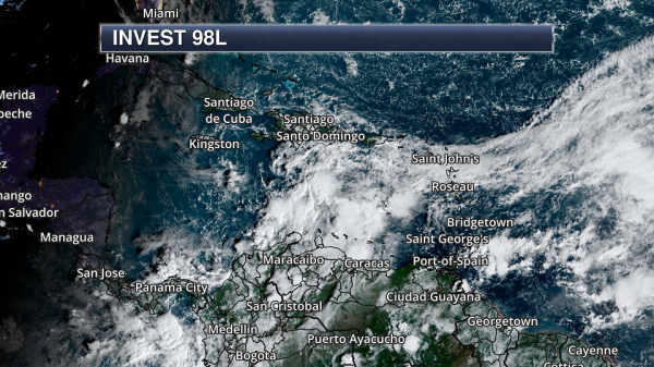
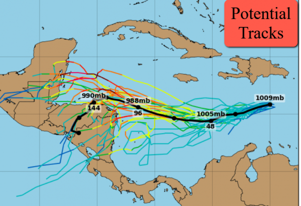
Caribbean Threat. We’re also tracking a tropical wave in the central Caribbean Sea which is becoming better organized. It is likely that this will form into a tropical depression in the next couple of days as it moves west, with an 80% chance of formation in the next two days and 90% in the next five days. Heavy rain that could cause flash flooding will continue across Hispaniola today. As of this morning models continue to take this system into Central America, where additional heavy rain on top of what fell from Eta will cause flooding issues.
D.J. Kayser, Meteorologist, Praedictix.
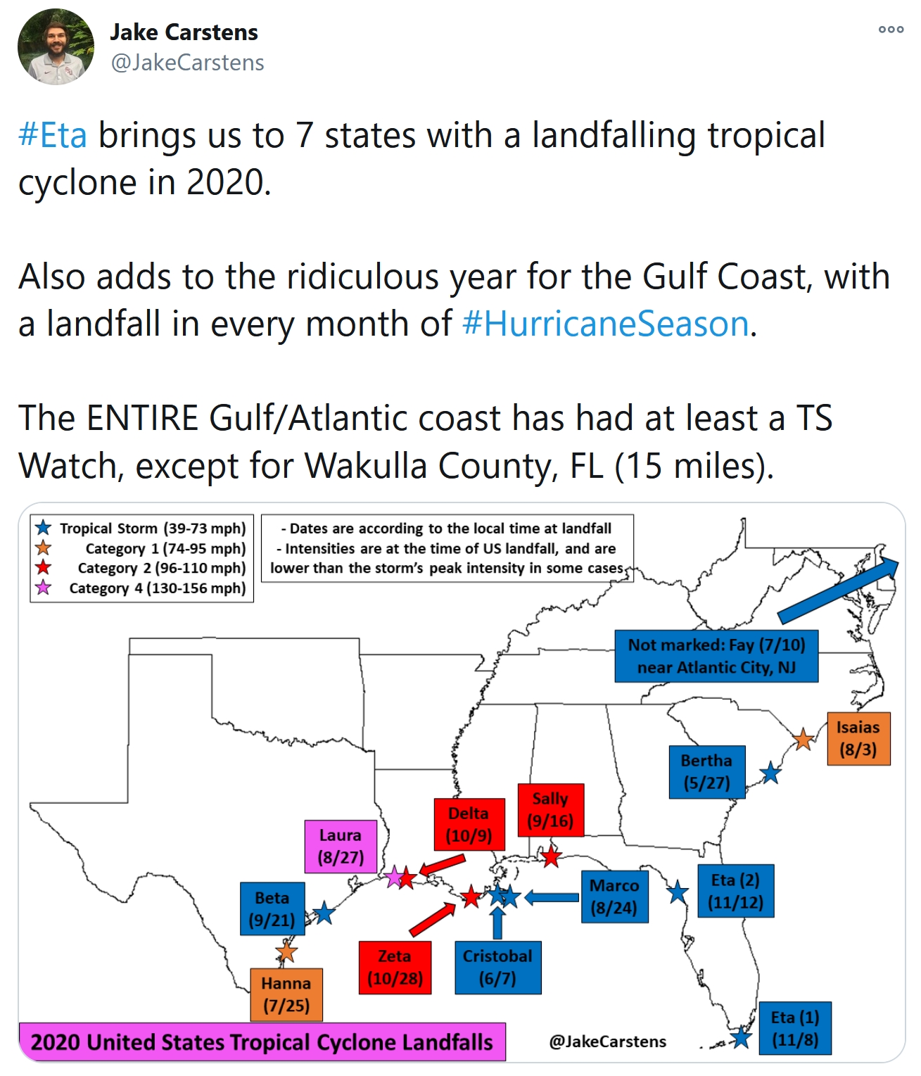
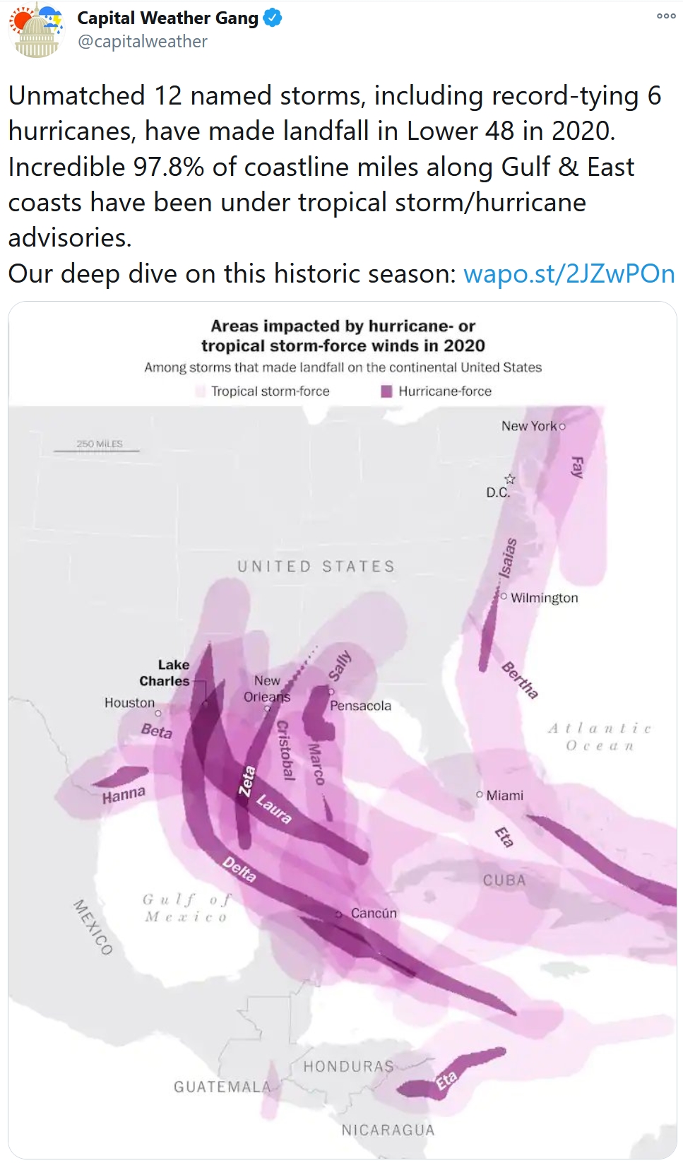
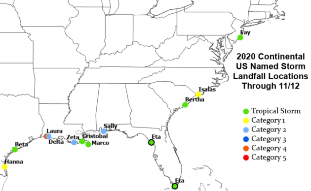
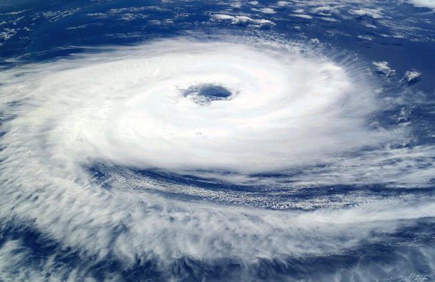
2020 Hurricane Season Breaks Record for Most Storms. Capital Weather Gang puts a crazy tropical season into perspective: “…The 29 storms are not only the mark of an unprecedented season statistically, but one that has left behind a devastating toll on the economy and people’s lives. An unmatched 12 named storms, including a record-tying six hurricanes, have made landfall in the United States in 2020, leaving few areas on the Gulf and East coasts untouched. Parts of the Gulf Coast have been hit repeatedly, the state of Louisiana seeing a record five storms make landfall alone. Several meteorological influences stacked the deck in favor of this punishing onslaught, while climate change may well have intensified the season’s activity and potentially expanded the zones in which storms have formed and gained strength. It may have also contributed to the season’s longevity...”
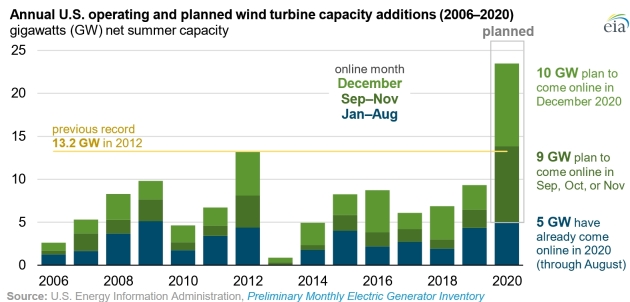
2020 Could Be a Record Year for U.S. Wind Turbine Installations. The U.S. Energy Information Agency (EIA) has details: “According to data collected by the U.S. Energy Information Administration (EIA), project developers expect more than 23 gigawatts (GW) of wind turbine generating capacity to come online in the United States in 2020, far more than the previous record of 13.2 GW added in 2012. Only 5.0 GW of capacity has come online in the first eight months of this year, according to EIA’s Preliminary Monthly Electric Generator Inventory, but as is typical with wind turbine installations, most of the annual capacity additions come online in the final months of the year. Another 18.5 GW plan to come online in September through December, according to project timelines reported to EIA by power plant owners and developers. The 5.0 GW of capacity added in the first eight months of 2020 is already more than the capacity added in the first months of any year except 2009…”

Is There a Safe Way to be Home for the Holidays? Some helpful advice from The Atlantic; here’s a clip: “...If you do decide to go somewhere, Morse told me, there are a number of precautions you can take that, combined, could reduce the risks of getting or spreading the virus. (But ramping up the caution or just skipping the trip would be a good idea if you or your loved ones are particularly vulnerable to the disease.)
- Consider visiting at an off-peak time—that is, not right around a holiday, when lots of other people might be traveling as well.
- Plan a smaller gathering than usual. The fewer people from different households, the better. (The number of attendees can be more important than the length of the visit: It’s not clear that shortening a visit marginally—say, from three days to two or from two weeks to one—will reduce risk in a predictable, linear way.)…”
Image credit: Paul Douglas
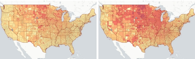
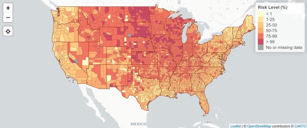
Thinking About a Holiday Gathering? Look at This Troubling Map First. WIRED.com makes the case; here’s an excerpt: “…Public health experts would really rather we not gather for the holidays, but they say that if you do go through with it, the shindig should be held outdoors, with as few people as possible, and everyone keeping their distance and wearing masks. But if you look at that map now, it shows that across the US, there’s no such thing as a perfectly safe way to gather during the pandemic. Even with all those precautions, the risk right now is huge, particularly if you’re in the Midwest or hosting anyone coming from the Midwest. For example, in Cook County (which includes Chicago), the chance of a Covid-positive person attending a gathering of just 10 people is around 50 percent. In Jones County, Iowa, that chance is a staggering 99 percent. North Dakota, South Dakota, and Kansas also have counties sitting at 99 percent…”
Map credit: “The striking difference between the risks of a gathering of 10 people at left and 25 people at right. Darker reds are higher risk.” Illustration: Aroon Chande via OpenStreetMap contributors CARTO.
COVID-19 Risk Assessment Planning Tool. Here is the website for the tool referenced above, to give you a better chance of virus risk and community spread: “This map shows the risk level of attending an event, given the event size and location. The risk level is the estimated chance (0-100%) that at least 1 COVID-19 positive individual will be present at an event in a county, given the size of the event. Based on seroprevalence data, we assume there are ten times more cases than are being reported (10:1 ascertainment bias). In places with more testing availability, that rate may be lower…”
Map credit: “The COVID-19 Event Risk Assessment Planning Tool is a collaborative project led by Prof. Joshua Weitz and Prof. Clio Andris at the Georgia Institute of Technology, along with researchers at the Applied Bioinformatics Laboratory and Stanford University, and powered by RStudio. Description of the method and analyses available at Nature Human Behaviour.”

Thermal Nuclear Engine Could Reach Mars in 3 Months. Popular Mechanics has the eye-opening details of a potentially faster way to reach the Red Planet: “Ultra Safe Nuclear Corporation (USNC) has designed a new thermal nuclear engine it says could carry astronauts to Mars in just three months—and back to Earth in the same amount of time. By using ceramic microcapsules of high assay low enriched uranium (HALEU) fuel, USNC’s thermal nuclear engine could cut the trip in half even from optimistic estimates. Thermal nuclear for propulsion is an old idea…using the astonishing heat generated by a nuclear reaction to push a rocket at speeds approaching the Star Trek realm compared to what we use today…”
Image credit: USNC-TECH.
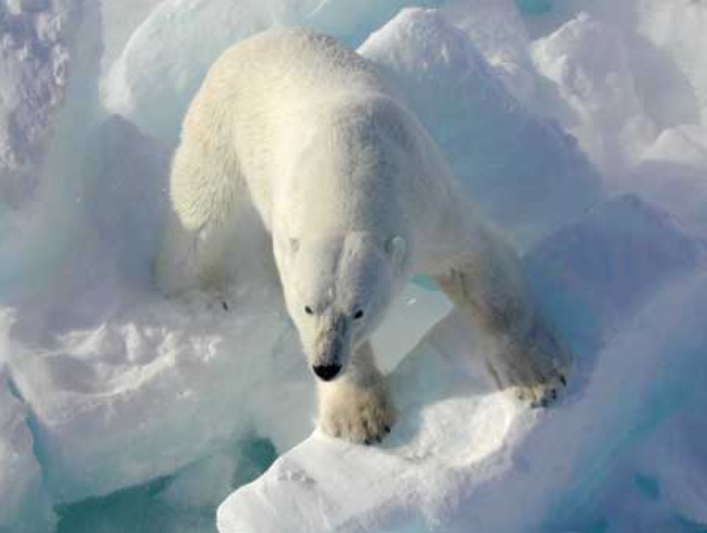
Polar Bear Doppler? I had no idea. The New York Post reports; here are a few excerpts: “Along the frosty coast of Hudson Bay, hundreds of polar bears have been wandering for weeks, waiting for the wintertime sea ice to form so they can return to hunting ringed seals. Until then, they represent a danger to the 900 people living in nearby Churchill… The town is working on a plan to prevent conflicts between hungry bears and humans, using a new radar system that can watch and warn when a bear approaches and do so in a snowstorm and during the dead of night… As climate change warms the Arctic faster than the rest of the world, the region has been drawing more tourists… With sea ice breaking up earlier and forming later, “we’re seeing more bears on shore in more places and for longer time periods…”
File photo credit: Wikipedia, USGS.
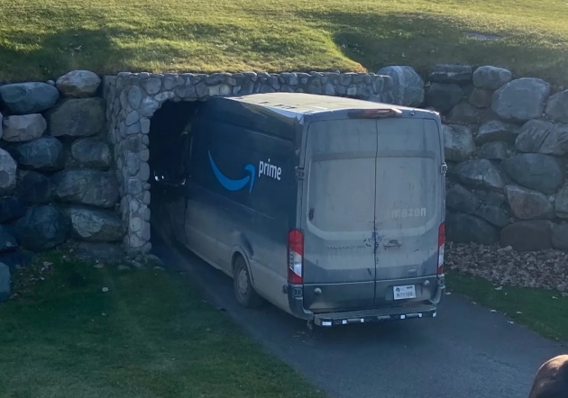
Ignore the GPS – Try Common Sense. USA TODAY has details: “An Amazon driver tried to drive through a cart tunnel at a golf course outside Detroit. The Amazon delivery truck was got wedged about six feet into the tunnel between the Dunes course ninth green and the clubhouse… The driver was apologetic and seemingly rather embarrassed, however, Offer said. The driver apparently took a wrong turn and didn’t realize his truck wouldn’t fit in the tunnel… golfers stopped to take their phones out to snap a photo...”
Photo credit: “A photo taken by Bill Offer, a club supervisor, shows an Amazon truck stuck in a golf cart tunnel about 2:30 pm November 7, 2020, at the Boulder Pointe Golf Club in Oxford, Michigan.” Courtesy of Bill Offer.

Mountain Dew is Releasing a Cookbook. Your dreams have been answered. The New York Post has details; here are a few excerpts: “…The soda brand is about to release the “Big Bold Book of MTN DEW Recipes,” a collection of about 40 recipes either made by fans, inspired by fans or just enjoyed by fans. It’s a celebration of Mountain Dew just ahead of the brand’s 80th anniversary… Recipes in the book include dishes like green pancakes, green eggs and ham, salsas, barbecue sauces, Mountain Dew-infused pickles, jalapeno poppers and Mountain Dew slushies… The cookbook will be available for sale for a limited time on the Mountain Dew online store the week of Nov. 16, according to the company. It will cost $30...”
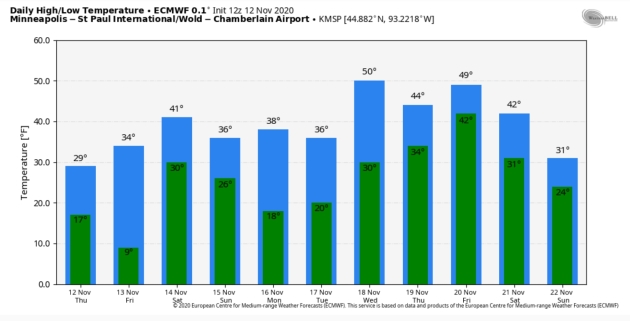
2.8″ snow fell at MSP yesterday.
31 F. maximum temperature yesterday in the Twin Cities.
43 F. average high on November 12.
20 F. high on November 12, 2019.
November 13, 1986: Lakes are frozen over throughout much of the state, reaching as far south as Winona.
November 13, 1938: A snowstorm develops across northern Minnesota. The barometer falls to 29.31 inches in Duluth.
November 13, 1933: The first Great Dust Bowl Storm occurs. The sky darkened from Minnesota and Wisconsin to New York State.

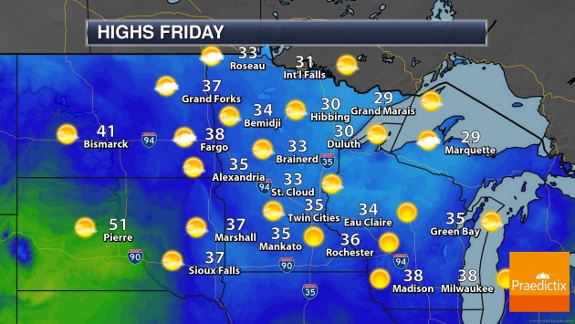
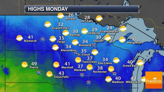
FRIDAY: Sunny and cool. Winds: S 10-15. High: 35
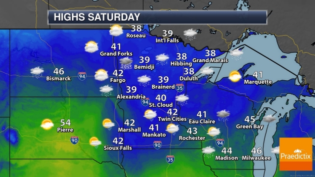
SATURDAY: A little rain or drizzle possible. Winds: S 10-20. Wake-up: 30. High: 41
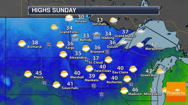
SUNDAY: Mostly cloudy, windy and cooler. Winds: NW 15-35. Wake-up: 32. High: 37
MONDAY: Blue sky, less wind. Winds: NW 8-13. Wake-up: 18. High: 38
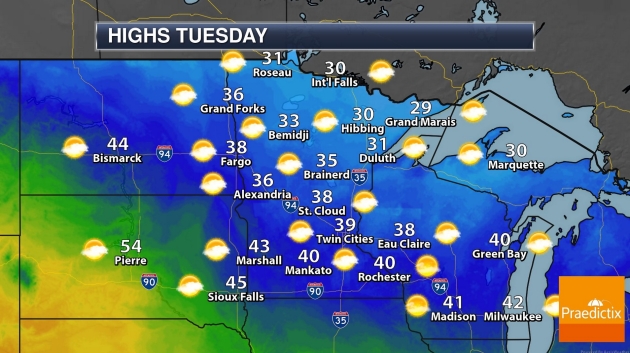
TUESDAY: Partly sunny, still quiet. Winds: E 8-13. Wake-up: 25. High: 36
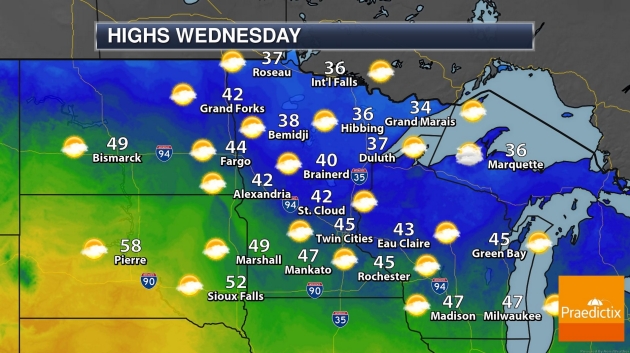
WEDNESDAY: Sunny and mild. Most snow gone. Winds: SE 10-15. Wake-up: 27. High: 49
THURSDAY: Mostly sunny, mostly pleasant. Winds: N 5-10. Wake-up: 33. High: 48
Climate Stories…

Big Oil Execs Say They’re Not Worried About Biden’s Energy Plan. Perhaps they should be, according to an article at CNBC.com: “The prospect of a Joe Biden presidency and the most progressive climate strategy the U.S. has ever attempted is not something that should concern the energy industry, oil and gas executives have told CNBC. Instead, they hope President-elect Biden will engage directly with them as he rolls out his energy plan. Biden, who has won the U.S. election according to NBC projections, has previously said that one of his first acts as president would be to reverse President Donald Trump’s decision to pull out of the Paris climate agreement, an international pact designed to avert the dangerous warming of the planet...”
Joe Biden’s Climate Plan Doesn’t Rely on Congress. TIME.com has analysis; here’s an excerpt: “…Among its many planks, the Biden campaign’s platform called for creating one million new jobs in the auto industry and electric-vehicle supply chain; spending billions on research and development of clean-energy technology; and supporting farmers who rethink agricultural production. “It’s not just an environmental plan or a climate plan,” says William K. Reilly, who served as Environmental Protection Agency administrator under George H.W. Bush. “It is very significantly connected to an industrialization and economic development plan, an infrastructure plan created as a result of a new energy economy...”

These Stocks Could Rise Further as Biden Takes on Climate Change. Here’s a clip from a post at Barron’s: “…Matt Patsky, CEO of Trillium Asset Management, said: “Broadly, a Biden win would lead to policies that would support the significant infrastructure needed to move to electrification of transportation, and away from dependency on the combustion engine and fossil fuels.” In addition, it accelerates the transition to clean power generation and improving efficiency. Winners include renewable energy, energy efficiency plays, industrial gas suppliers, providers of equipment and services in rail, environmental consulting, consulting firms focused on environmental permitting and siting, and water infrastructure. Many have already run up sharply, but Patsky thinks they have more headroom…”
5 Things We Know About Climate Change and Hurricanes. Yes, there’s a connection. Here’s an excerpt from an explainer at The New York Times (paywall): “The tumultuous season has raised questions about how much climate change is affecting hurricanes in the Atlantic. Researchers can’t say for sure whether human-caused climate change will mean longer or more active hurricane seasons in the future, but there is broad agreement on one thing: Global warming is changing storms. Scientists say, for example, that unusually warm Atlantic surface temperatures have helped to increase storm activity this season. The warmer ocean temperatures are “absolutely responsible for the hyperactive season,” said James P. Kossin, a climate scientist with the National Oceanic and Atmospheric Administration. “It’s very likely that human-caused climate change contributed to that anomalously warm ocean…”
Hurricane Joaquin file image: NOAA.
Hurricanes Could Reach Farther Inland Due to Climate Change, Study Suggests. CBC News summarizes the findings and predictions: “Hurricanes that make landfall are maintaining their strength longer because of climate change, a new study suggests, meaning such storms could have more of an impact than in the past. The reason storms are maintaining their strength, according to researchers at the Okinawa Institute of Science and Technology Graduate University (OIST), is the increase in sea surface temperatures. A hurricane needs several things to form, the main one being warm water. When warm, moist air rises from that water, it’s replaced by cooler air which in turn warms and rises. Clouds form and then, under the right conditions, begin to rotate with the spin of Earth. Given enough warm water, the cycle continues and a hurricane forms…”
File image: NASA.
Hurricanes Are Staying Stronger Even Over Land as Oceans Warm From Climate Change, Study Finds. More perspective from Capital Weather Gang: “…Now a new study, published Wednesday in the journal Nature, shows that storms such as Michael that extend their damaging path far inland are becoming more likely to occur as ocean temperatures increase in response to human-caused global warming. The study, by Lin Li and Pinaki Chakraborty, scientists at the Okinawa Institute of Science and Technology, identifies trends in observed hurricane behavior among landfalling storms in the North Atlantic Basin during the 1967 to 2018 period. They found a slower rate of hurricane decay, defined as the decrease in storm intensity during the first 24 hours after a storm makes landfall, since they’re now holding onto more moisture picked up from warmer seas…”
File image: NOAA.
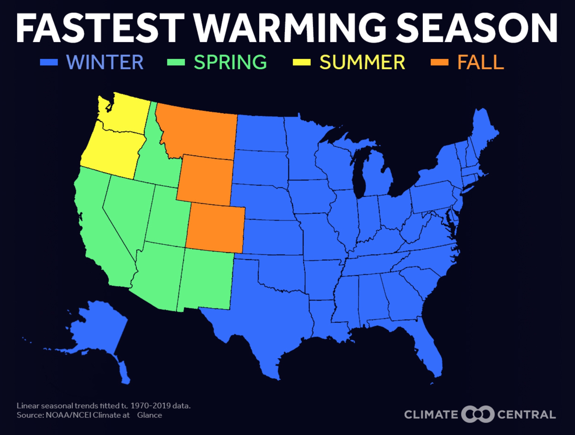
Winter: Fastest Warming Season for Most of USA. It still snows, we still experience cold fronts, but winter-shrinkage is a thing, according to Climate Central: “Climate Central found that winter is the fastest warming season for most of the country, in 38 of the 49 states analyzed. States seeing the fastest winter warming are clustered in the Northeast and the Great Lakes region. The transition seasons of fall and spring are the fastest warming across much of the western United States. In Washington and Oregon, summers are warming most quickly, increasing the risks associated with wildfire season. Rising temperatures can contribute to a longer allergy season, keep disease-carrying insects active, shift growing seasons and zones, and prolong the wildfire season. And potential winter energy savings from not having to turn up the thermostat are offset by the warmer summer and fall seasons that have increased our demand for cooling…”
Climate Change Will Force a New American Migration. A slow-motion retreat from the most vulnerable coastal areas and fire-prone regions of the west has already begin. ProPublica reports: “…I had an unusual perspective on the matter. For two years, I have been studying how climate change will influence global migration. My sense was that of all the devastating consequences of a warming planet — changing landscapes, pandemics, mass extinctions — the potential movement of hundreds of millions of climate refugees across the planet stands to be among the most important. I traveled across four countries to witness how rising temperatures were driving climate refugees away from some of the poorest and hottest parts of the world. I had also helped create an enormous computer simulation to analyze how global demographics might shift, and now I was working on a data-mapping project about migration here in the United States. So it was with some sense of recognition that I faced the fires these last few weeks. In recent years, summer has brought a season of fear to California, with ever-worsening wildfires closing in…”