
Minnesota Deer Opener Statistics And Forecast
Saturday is the annual Minnesota Deer Opener as hunters will be heading out into the woods in blaze orange. Do you remember last years opener, when International Falls saw 6″ of snow? Here’s more from the Minnesota Climatology Department and the MN DNR: “Minnesota’s 2018 Firearm Deer Hunting Opener is Saturday, November 3. The normal high temperature for November 3 ranges from the upper 30s across northern Minnesota to the upper 40s near the Iowa border. The average low temperature is in the 20s to low 30s. The historical probability of receiving measurable precipitation on November 3 is approximately 25%. Early November precipitation often falls as snow in the north, while rain is more likely in the south. An enduring, winter-long snow cover is typically not established until later in November, even in northern Minnesota. There has been significant snowfall on the Firearm Deer Hunting Opener in recent memory. 6.0 inches of snow fell at International Falls on the Deer Hunting Opener in 2017. In St. Cloud, a mere 0.3 inches fell, but there was a snow cover of 4 inches. The 2017 Firearm Deer Hunting Opener was cold and wintry with 30s to low 40s statewide.”
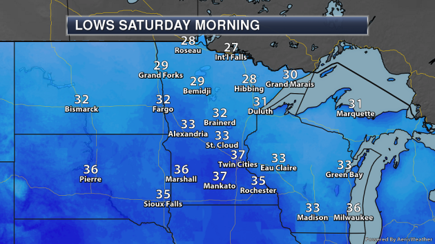
A system pushing out of the Rockies will start to bring some slight chances of rain and snow across the state by the time hunters wake up Saturday morning, but better chances of precipitation will hold off until later in the day. Temperatures will be in the 20s up north as you head out to your stands, with 30s expected across central and southern Minnesota.
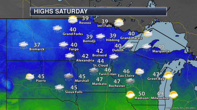
Those precipitation chances will expand across most of the state as we go through Saturday, with highs ranging from around 40 up north to the mid and upper 40s in southern Minnesota. Precipitation will be mainly in the form of rain across southern Minnesota, with a mix of rain and snow possible as you head northward.
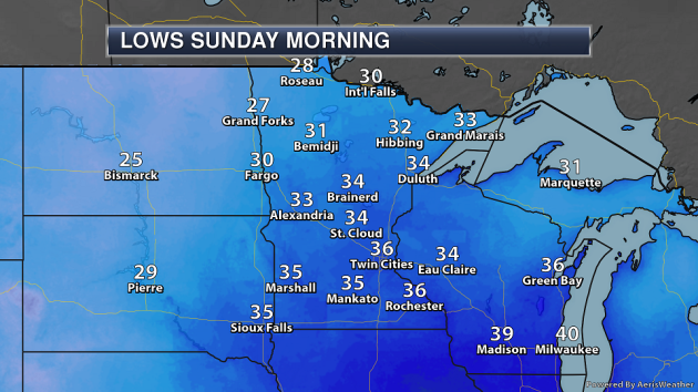
Lows will dip again into the 30s across most of the state Sunday morning with some 20s possible in northwestern parts of the state. Precipitation will still be occurring, so some changeover to all snow across northern Minnesota will be possible during the overnight and early Sunday morning hours.
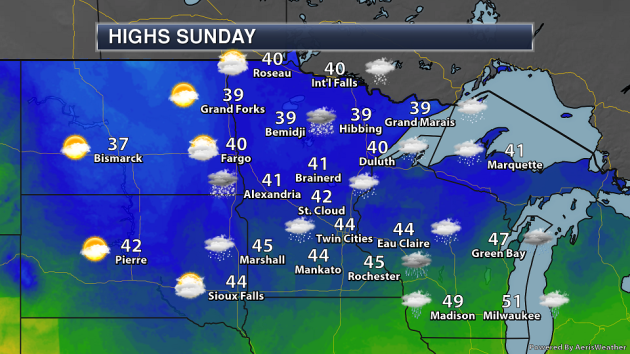
Precipitation will be slow to move out of the region Sunday, working its way west to east. By Sunday evening, only eastern Minnesota will hold on to precipitation chances, but it could linger in the Arrowhead through Sunday Night into early Monday. Highs will be in the upper 30s to mid-40s across most of the state.
_______________________________________________
National Weather Forecast
On Friday, a front moving eastward will bring chances of showers and storms along the Eastern Seaboard, driving in some cooler temperatures as well. A weakening area of low pressure will bring rain to parts of the Ohio Valley as well as rain and snow in the western Great Lakes. An area of low pressure moving out of Canada will spread rain and snow across parts of the northern and central Rockies as well as the northern Plains. In the Pacific Northwest, a cold front nearing the coast will bring a round of heavy rain and higher elevation snow.
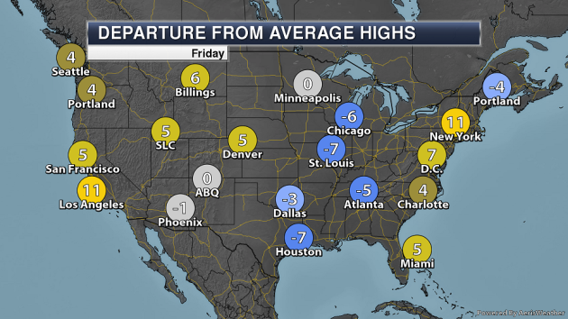
Behind the front moving eastward Friday, temperatures will be 5-10 degrees below average across the upper Midwest and Mississippi Valley. Highs will be above average across most of the west and east coast areas.
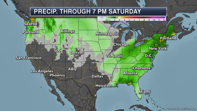
A couple areas of heavy rain will be possible into the first half of the weekend. First, some areas of the Northeast and Southeast could pick up 2-3″+ of rain due to the cold front moving through the region. Heavy precipitation will also be possible in the Pacific Northwest, with the potential of 3-4″+ of precipitation for the Cascades and Olympics.
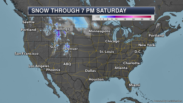
Over a foot of snow is possible in some of the higher elevations of the Rockies over the next couple days, with 2-5″ possible in parts of North Dakota Friday into Saturday.
_______________________________________________
_______________________________________________
Historic flooding in Italy: What role has climate change played in the destruction?
More from USA Today: “At least 11 people have died in Italy this week due to historic flooding throughout the country, officials said Tuesday. In Venice, more than 70 percent of the city was inundated as water levels rose over five feet above normal. In addition to heavy rain, sea water was also pushed into the city by a powerful storm and exacerbated by high tides. In fact, Venice saw its fourth-largest tides since at least 1936, according to the city’s website. The famous tile floor in Saint Mark’s Cathedral was damaged as the basilica flooded for just the fifth time in nine centuries, Italian media reported.”
Oceans warming faster than anticipated, giving even less time to stave off worst impacts of climate change, study finds
More from the Los Angeles Times: “The world’s oceans may be heating up faster than previously thought — meaning the planet could have even less time to avoid catastrophic global warming than predicted just weeks ago by the United Nations’ Intergovernmental Panel on Climate Change. According to a study published Wednesday in the journal Nature, ocean temperatures have been warming 60% more than outlined by the IPCC. “The ocean warmed more than we thought, and that has serious implications for future policy,” said Laure Resplandy, a researcher at Princeton University’s Environmental Institute who coauthored the report. “This is definitely something that should and will be taken into account in the next report.” The new study, authored by scientists at Princeton University, UC San Diego’s Scripps Institution of Oceanography and a number of other research centers around the world, is not the first to suggest oceans could be warmer than previously thought. The report, however, relies on a novel approach that could revolutionize how scientists measure the ocean’s temperature. The findings would need to be reproduced in coming years to gain widespread acceptance throughout the scientific community.”
New research shows the toll climate change is taking on Florida farmworkers
More from ThinkProgress: “Climate change is taking a heavy toll on farmworkers in Florida, where new research indicates excessive heat stress is increasingly becoming a public health problem with severe human rights and economic implications for the state. A new report released Tuesday by the non-profit organization Public Citizen, along with the Farmworker Association of Florida (FWAF) and a researcher at Emory University, corroborates what advocates have argued for years: that climate change is impacting farmworkers in Florida. An analysis of temperature data for all of the state’s 67 counties between May 1 and September 30, 2018, found that workers across Florida were exposed to dangerous levels of heat — temperatures above 82.4°F for moderate work and 78.8°F and 77°F for heavy and very heavy work respectively. Long-term exposure to high temperatures can spark fatigue and nausea, along with heat stroke, dehydration, and over a prolonged period, organ failure. This temperature assessment was then combined with a study from Emory which had 250 Florida workers wear special equipment while working in order to study their reactions to heat. Blood and urine samples were also collected as part of the study, which ultimately found that four out of five workers were exceeding 100.4°F in body temperature on at least one day during the study, increasing their susceptibility to heat illness.”
_______________________________________________
Thanks for checking in and have a great Friday! Don’t forget to follow me on Twitter (@dkayserwx) and like me on Facebook (Meteorologist D.J. Kayser)!
– D.J. Kayser
