
NEOWISE Hunting
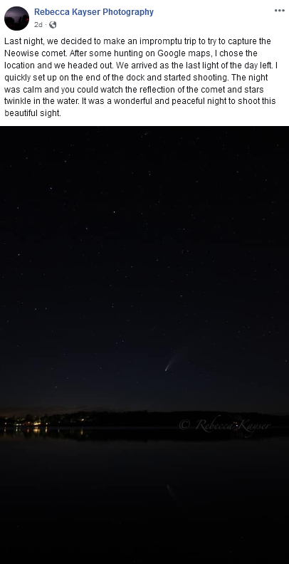
Photo Credit: Rebecca Kayser Photography on Facebook
My wife and I went out Wednesday night into central Minnesota to see the comet NEOWISE after sunset, and we certainly had a spectacular view! You can still view NEOWISE if you head out about an hour to an hour and a half after sunset looking to the northwest as the comet continues to rise higher in the sky over the next few days. It’s making its closest approach to Earth on Wednesday (the 22nd) – about 64 million miles away. Below is a look at the forecast around 10 PM for Sunday and Monday Night:


_______________________________________________
National Weather Forecast

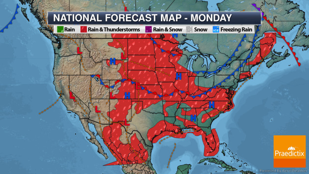
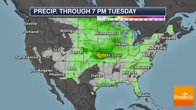
The heaviest rain through Tuesday evening will be in the central U.S., where over 3″ could fall Sunday night into early Monday around and just south of Kansas City.
_______________________________________________
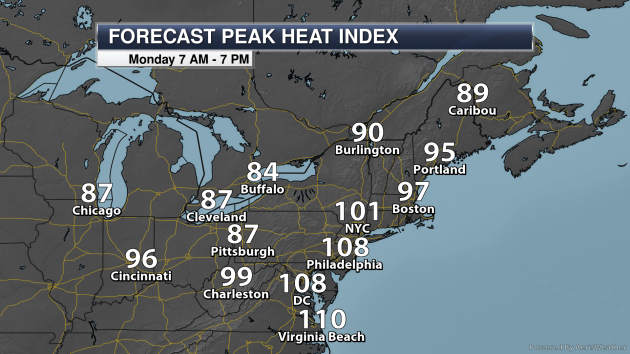
Northeast Heat
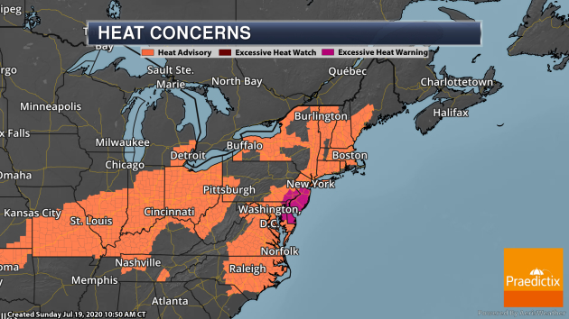
Heat concerns will continue in the Northeast as we head into the beginning of the work week, with an Excessive Heat Warning in place for Philadelphia. Areas like Philadelphia and D.C. will see heat index values approach 110F during the afternoon hours Monday, with peak heat index values just over 100F in New York City.
_______________________________________________
Watching The Gulf Of Mexico
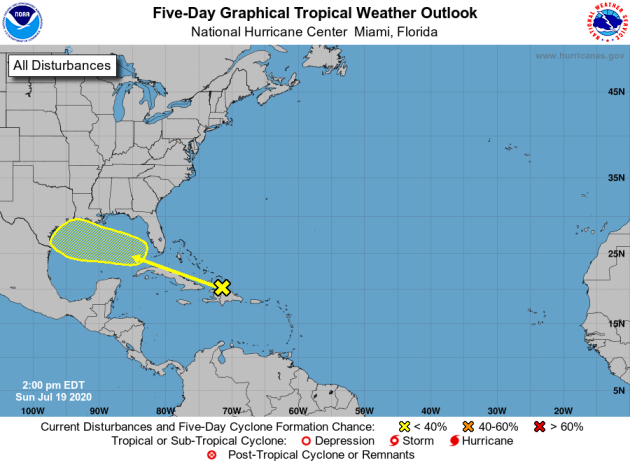
As we head through the middle of the work week, we will be watching an area of low pressure move into the Gulf of Mexico. Atmospheric conditions could be at least marginally capable to allow some development with this system, but chances of it forming into a tropical system over the next five days are low. Either way, this should bring some rain to the Gulf Coast states through the middle and end of the week.
_______________________________________________
Weather forecasts are less accurate because of Covid-19, a new study reveals
More from CNN: “As the US heads into peak hurricane season, a reduction in commercial airline flights due to Covid-19 has significantly impacted our ability to accurately forecast the weather. A study out this week by Dr. Ying Chen, a senior research associate at Lancaster University’s Environment Centre, highlights this problem. The study found that the “accuracy of surface meteorology forecast in March-May 2020 decreases remarkably” as flight density drops due to Covid-19. The research examined weather forecasts from March 2020 and compared them to actual observed weather in the same time frame.”
Not just coronavirus — heat also poses a threat to public health this summer
More from The Conversation: “In the era of COVID-19, park-goers in places like Toronto’s Trinity Bellwoods Park are now neatly organized within small, white circles — a clever strategy to maintain adequate physical distance between social bubbles. Although many Canadians welcome the warmer weather with outstretched arms and open-toe shoes, we must acknowledge another threat we face this summer: the heat. July has seen record-breaking heat scorch the southern United States where coronavirus cases have been rising rapidly. Heat is also sweeping across Ontario and Québec, offering little relief at night. The outlook looks hot too: An immense heat dome is parked over North America, threatening to bring a long, intense heat wave through mid-July.”
We should start giving names to extreme heat waves
More from Fast Company: “As a prolonged heat wave bakes states like Florida and Texas, it’s happening at the same time as coronavirus cases spike, which means people are stuck at home. If they don’t have air-conditioning, it’s likely to lead to early deaths: Extreme heat kills more Americans each year than disasters like hurricanes, tornadoes, or floods, and as climate change progresses, the problem is getting worse. But heat waves rarely get as much attention as something like an approaching tropical storm. In New York City, a new report called Turning the Heat from the nonprofit Urban Design Forum looks at creative ways to deal with the fact that the city is getting hotter. One simple suggestion: Give serious heat waves names.”
_______________________________________________
Thanks for checking in. Don’t forget to follow me on Twitter (@dkayserwx) and like me on Facebook (Meteorologist D.J. Kayser)!
– D.J. Kayser
