
It’s Been A Snowy Winter…

After our very snowy February, winter snowfall totals have quickly climbed across the region. Through Saturday, the Twin Cities sat at 62.4″ of snow, 19.9″ above average through March 2nd. This actually already surpasses our yearly snowfall average of 54.4″ as well. Snow totals so far this winter are already in the 80″+ range in Duluth, Eau Claire, and Wausau… and Rhinelander has surpassed 100″ of snow.
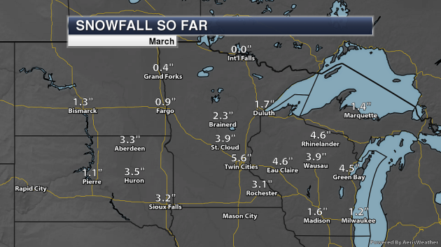
And already this month 5.6″ of snow has fallen in the Twin Cities (all during the day on Friday)… which is more than half the average amount of snow that falls during the month of March (10.3″).
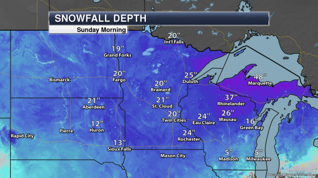
As of Sunday morning, there was 25″ of snow on the ground at MSP with 21″ in St. Cloud and 25″ in Eau Claire.
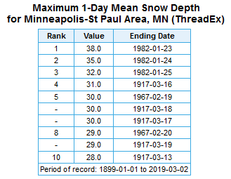
Going back to Saturday morning, though, MSP airport had 21” of snow of the ground. That actually ranks in the top 100 snow depths ever recorded for the long-term Twin Cities data site! It ranks as a tie for 98th place. Instead of showing the entire chart down to 98th place, here the top ten deepest snow packs on record for MSP – you only have to go back to January of 1982 for the deepest, which was 38” on the 23rd of that month.
_______________________________________________
Wind Chill Concerns Once Again Sunday Night
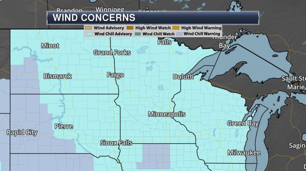
Wind Chill Advisories are in place across much of the state once again for Sunday Night as the combination of temperature and wind will create wind chill values of at least -25F. Here is the text for the Wind Chill Advisory in place for the Twin Cities:
...WIND CHILL ADVISORY REMAINS IN EFFECT FROM 8 PM THIS EVENING TO 9 AM CST MONDAY... * WHAT...Dangerously cold wind chills of 25 below to 35 below zero. * WHERE...Portions of northwest and west central Wisconsin and east central and southeast Minnesota. * WHEN...From 8 PM this evening to 9 AM CST Monday. * ADDITIONAL DETAILS...The dangerously cold wind chills could cause frostbite on exposed skin in as little as 10 minutes.
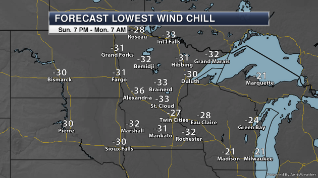
Here’s a look at the coldest wind chill values Monday morning across the state, with many areas dropping into the -30s.
_______________________________________________
Observed Lows Sunday Morning
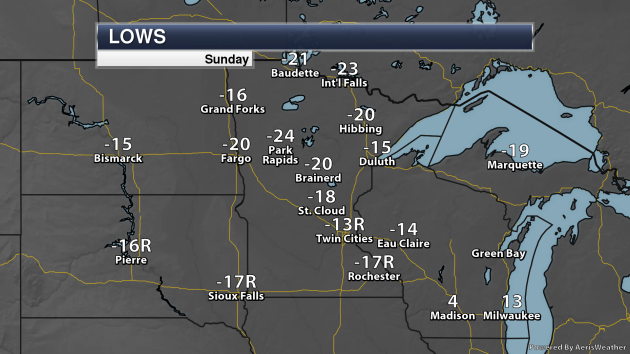
It was an awfully cold start to Sunday across the state, so cold that records were even tied or broken. As you can see, the Twin Cities got down to -13F, which tied the record for the day previous set in 1873. Rochester also tied their record low for the day at -17F, previously set in 1913.
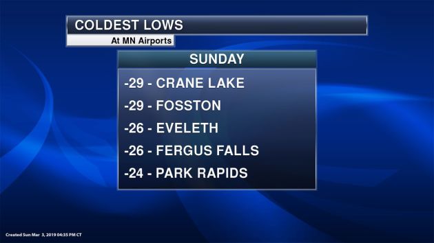
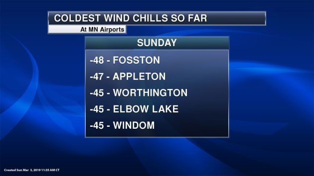
Here’s a list of the coldest lows at airport locations. The coldest low overall I could find across the state was -29F in Fosston, Crane Lake, and Kabetogama, followed by -28F in Embarrass.
_______________________________________________
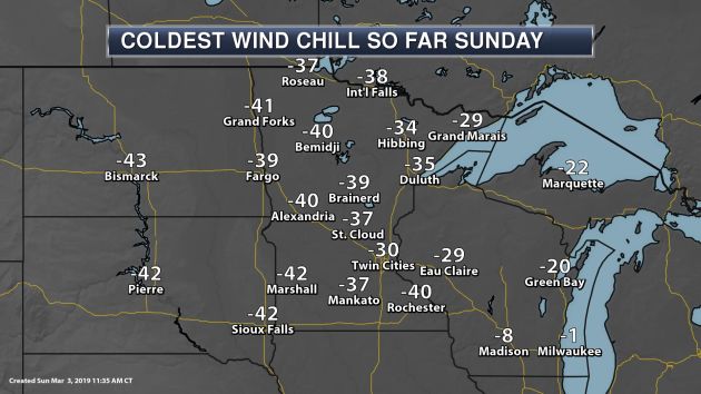
Wind Chills Sunday Monrning
_______________________________________________
Very Cold Highs Sunday
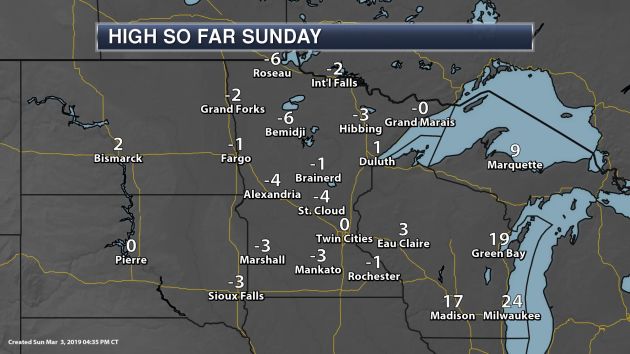
Yes, it was a historic Sunday here in the Twin Cities, as we shattered the previous record cold highs for the day by only making it to 0F. The record for the day was 6F set back in 1873. Pretty much all other NWS long-term climate locations set new record cold highs Sunday. Here’s what the records were for the day:
- Duluth: 2 (2002)
- International Falls: 3 (2002)
- Twin Cities: 6 (1873)
- Rochester: 6 (2002)
- Saint Cloud: 3 (2002)
- Brainerd: 5 (2002)
- Hibbing: 3 (2002)
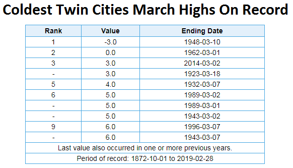
Sunday’s high will also end up being tied for the 2nd coldest March high in Twin Cities history, and we just barely avoided Sunday becoming the second day on record that didn’t make it out of the negative range.
_______________________________________________
Lake Superior Ice
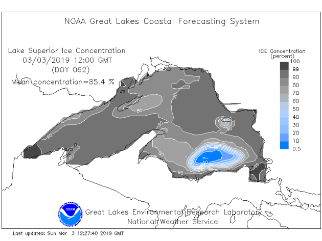
As of Sunday morning, 85.4% of Lake Superior had ice according to NOAA’s Great Lakes Environmental Research Laboratory, with the largest open area of water out in the southwestern portion of the late.
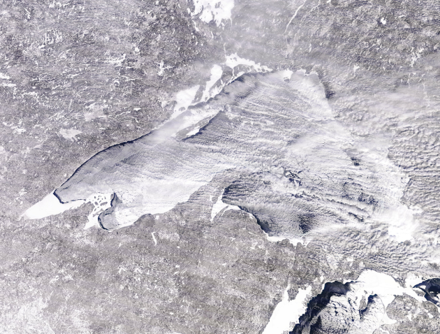
Here was a gorgeous shot of the lake around midday Sunday from MODIS. You could see where there is still some open water on the lake, especially near the North Shore from near Castle Danger northeastward.
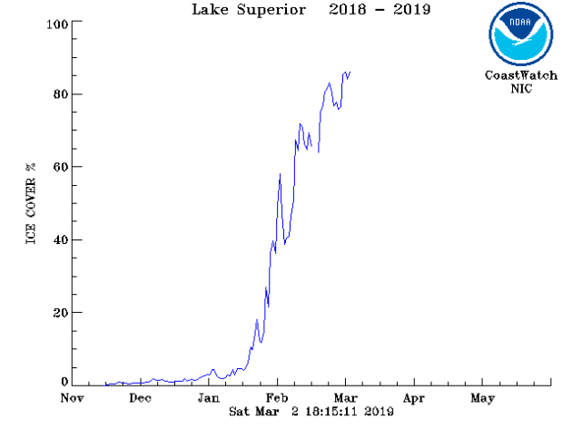
Over the past few days, the amount of ice coverage has hovered around 85% on Lake Superior. You can see a dramatic increase in the ice coverage over the past several weeks when we have been dealing with cold weather.
_______________________________________________
Monday National Weather Forecast
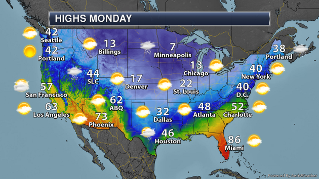
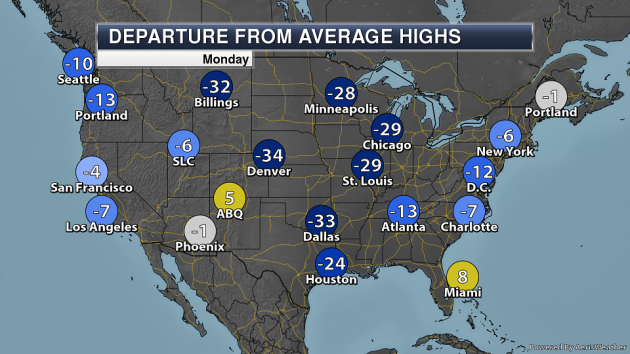
On Monday, snow (and some mixed in rain along the Massachusetts coast) will continue across parts of New England with a departing storm system. The cold front extending southward from that low will produce some showers and storms in parts of Florida. Some lake effect snow will occur, especially downwind of Lake Michigan. A trough of low pressure passing through the upper Midwest may spark off a few snow showers or flurries. A few showers will be possible along the western and northern Gulf Coast. Meanwhile, snow will be tapering off in the central Rockies and Intermountain West. Highs will once again be far below average in the central part of the nation including over 30F below average for areas like Billings, Denver, and Dallas.
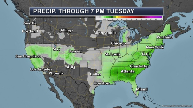
The heaviest rain Sunday through Tuesday will be across parts of the Southeast where 1-2″+ could fall, mainly Sunday into Sunday Night.
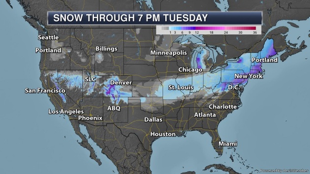
Some 6″+ snowfall tallies are expected Sunday Night into Monday in parts of the Northeast with that area of low pressure moving off the coast. Some heavier snow will also be possible downwind of the Great Lakes and in the Colorado Rockies.
_______________________________________________

Praedictix Corporate Weather Briefing: Sunday morning, March 3rd, 2019
- As a system continues to track east across the country, snow will continue to be possible from the Central Plains into New England today and Monday.
- The heaviest snow will fall from the central Appalachians into New England, where snow totals of 5-10” will be possible. This includes the New York City and Boston areas. Numerous Winter Storm Warnings and Winter Weather Advisories are in place due to the snow potential.
- An Enhanced Risk of severe weather is also in place today across portions of the Southeast. Damaging winds and a few tornadoes are the main risks.

Sunday Morning Radar. Snow was falling this morning across parts of the Central Plains into the Ohio Valley. Some reports of mixed precipitation, including sleet, have come out of northern Arkansas as well. The heaviest reported snow totals so far have come out of Nebraska and Kansas, where 7” was reported in Colby (KS) and Chadron (NE), 6.5″ was reported in Leoti (KS), and 6″ was reported in North Platte (NE).

Snow To Move Into The Northeast Later Today. Snow will continue to spread eastward today, making it into the Northeast this afternoon into the evening hours. The heaviest snow for areas like Philadelphia, New York City, and Boston will fall during the overnight hours. This snow will quickly push out of Philadelphia and New York City by the Monday morning commute, but a rain/snow mix could last through the midday hours in Boston. By Monday evening, any remaining snow will be falling across far northern New England.

Winter Storm Alerts. Due to this system continuing to move across the county, numerous winter weather alerts are in place from the Central Plains to New England. Some of the cities under alerts include:
- Dodge City, KS: Winter Storm Warning until Noon today for total snow accumulations of 4-6” as well as blowing and drifting snow with wind gusts up to 35 mph.
- Lubbock, TX: Winter Weather Advisory through 10 AM today for a glaze of ice.
- Kansas City, MO: Winter Weather Advisory through Noon today for total snow accumulations of 3-5” as well as blowing snow.
- St. Louis, MO: Winter Weather Advisory through 3 PM today for 3-4” of snow.
- Cincinnati, OH: Winter Weather Advisory through 7 PM tonight for up to 2” of snow.
- Pittsburgh, PA: Winter Weather Advisory from 10 AM today to 1 AM Monday for 2-5” of snow.
- Baltimore, MD: Winter Weather Advisory from 2 PM today to 4 PM Monday for 2-4” of snow and sleet.
- Philadelphia, PA: Winter Storm Warning from 3 PM today to 7 AM Monday for 4-7” of snow and sleet.
- New York City: Winter Storm Warning from 1 PM today to 7 AM Monday for 5-8” of snow.
- Boston, MA: Winter Storm Warning from 7 PM tonight to 10 AM Monday for 5-7” of snow.
- Portland and Augusta, ME: Winter Storm Watch from this evening through Monday afternoon for 6”+ of snow.

North Central Snow. The heaviest snow across the North Central region will fall across parts of Kansas, where overall totals of up to 7” are possible. Places from St. Louis to Indianapolis are expected to see 1-4” of snow throughout the day.

Expected Northeast Snow. A band of 5-10” of snow is expected to fall from later today into Monday from the central Appalachians into New England. This snow will fall moderately to heavily at times across the region and is likely to impact travel across the region, especially tonight and for the Monday morning commute.
Forecast Snow In The Washington D.C./Baltimore Area:

Forecast Snow In The New York City Area:


Enhanced Severe Risk Today. Meanwhile, this system will also produce the potential of severe weather in the Southeast today. An Enhanced Risk of severe weather is in place across southern Alabama into central Georgia, including Montgomery (AL) and Macon (GA). Storms that form this afternoon ahead of a cold front will be capable of damaging winds and a few tornadoes (some of which could be strong).
D.J. Kayser, Meteorologist, Praedictix
_______________________________________________
Los Angeles failed to hit 70 degrees in February for the first time in recorded history
More from the Washington Post: “For the first time on record, Los Angeles went an entire February without once hitting 70 degrees. And the City of Angels registered its coldest month since 1962, averaging about five degrees colder than normal. The city of 4 million is known for its mild winters and picture-perfect paradise weather. The average February high is 65, but this February was the exception, coming in about 3.5 degrees below normal and never making it above their Feb. 12 high of 69. In fact, only three days last month were as warm as a typical February day in Los Angeles. “There has never been a February since records began in … 1877, during which the temperature has failed to reach the 70 degree mark,” wrote the National Weather Service in Oxnard, Calif., in a public information statement. This year marks the “first February in 141 Februaries without a high temperature of at least 70 degrees.” An average February hits 70 degrees half a dozen times.”
Australia Just Sweated Through Its Hottest Summer Ever
More from Earther: “In case you haven’t heard, it’s been hot in Australia. So it comes as no great shock that the Australian government has officially declared the summer of 2018-19 the country’s hottest on record. “It won’t come as a surprise to many that this summer will be our warmest on record,” Andrew Watkins, manager of long-range forecasting at Australia’s Bureau of Meteorology, said in a statement released Thursday. Australia’s summer got off to a sizzling start when a record-setting heat wave caused temperatures to spike up to 22 degrees Fahrenheit above normal in Victoria, South Australia, and Western Australia near Christmas. Feverish weather persisted into January, which saw heat wave after heat wave and was eventually declared Australia’s hottest month ever. In New South Wales, residents sweated through the hottest night the country had ever recorded when the mercury failed to drop below 97 degrees. The Australian Open suffered, as did thousands of flying foxes that lost their lives to the heat. Mass dieoffs of fish in the Murray-Darling river basin were at least partially attributable to the temperature, according to the AFP. Parts of Australia burned up, including Tasmania.”
Climate Change Is Having a Major Impact on Global Health
More from Scientific American: “A devastating heat wave swept across Europe in 2003, killing tens of thousands of people, scientists estimate. Many were elderly, with limited mobility, and some already suffered from chronic diseases. But climate change is making such extreme weather more common—and the effects will not be limited to the old and sick. Warming temperatures do not only threaten lives directly. They also cause billions of hours of lost labor, enhance conditions for the spread of infectious diseases and reduce crop yields, according to a recent report. The report, published last December in the Lancet, represents the latest findings of the Lancet Countdown—a coalition of international research organizations collaborating with the World Health Organization and the World Meteorological Organization. The group tracks the health impacts of—and government responses to—climate change. “It affects everyone around the world—every single person, every single population. No country is immune,” says Nick Watts, executive director of the Lancet Countdown and one of many co-authors of the report. “We’ve been seeing these impacts for some time now.””
_______________________________________________
Thanks for checking in and have a great Monday! Don’t forget to follow me on Twitter (@dkayserwx) and like me on Facebook (Meteorologist D.J. Kayser)!
– D.J. Kayser
