
In light of the risk Florence and Olivia pose to the U.S., we’re publicly releasing our morning briefings on our blog. Check back daily for more updates.
Praedictix Briefing: Tuesday morning, September 11th, 2018
- Hurricane Florence has weakened a little overnight, but is expected to restrengthen over the next 24-36 hours, potentially approaching Category 5 strength. As of 8 AM AST, Florence had 130 mph and was moving to the west-northwest at 15 mph
- Weather conditions will deteriorate across the Mid-Atlantic Wednesday Night into Thursday as Florence approaches as a dangerous major hurricane, even though some slight weakening is expected before landfall. Landfall is expected along the North Carolina coast, potentially near Jacksonville, Thursday Night or early Friday.
- Hurricane Watches – including locations like Hatteras, Greenville, New Bern, Jacksonville, and Wilmington (NC) and Myrtle Beach and Charleston (SC) – as well as Tropical Storm Watches (including Fayetteville, NC) have been issued.
- Numerous impacts can be expected from Florence, including the following:
- Hurricane-force wind gusts (74+ mph) across areas under the Hurricane Watch late Thursday into early Friday.
- Heavy rain and inland flooding, especially if Florence slows down/stalls out across the Mid-Atlantic into the weekend. Some areas could receive at least one to two feet of rain if this occurs, leading to disastrous flooding. Areas that could see at least 6” of rain from Florence include Wilmington, Raleigh, Greenville (NC), Richmond, Charlottesville, and Lynchburg (VA), and Washington D.C.
- A coastal storm surge of 5-12 feet will be possible along and especially to the north of where Florence makes landfall along the North Carolina coast. Storm Surge Watches have been issued from Edisto Beach South Carolina to the North Carolina-Virginia border, including Albemarle and Pamlico Sounds and the Neuse and Pamlico Rivers.
- Tropical Storm Olivia will start to impact Hawaii later today, crossing over the islands over the next couple days. Tropical Storm Warnings are in effect for the Big Island, Maui County, and Oahu, with a Tropical Storm Watch for Kauai.
- Super Typhoon Mangkhut could have impacts on southeastern Asia into the weekend.
- We’re also tracking a few other tropical systems in the Atlantic and Pacific, Meanwhile, an area of disturbed weather across the northwestern Caribbean has a 60% chance of become a tropical system late in the week as it moves into the Gulf of Mexico.
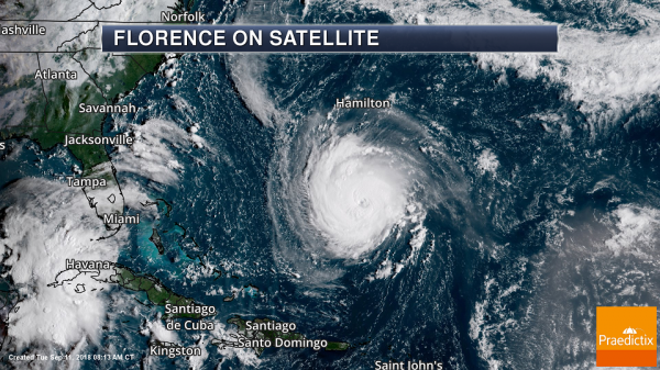
Florence As Of Tuesday Morning. Florence has weakened slightly this morning as the system undergoes an eyewall replacement. As of the 8 AM AST update from the National Hurricane Center, Florence was a Category 4 hurricane with wind speeds of 130 mph. The storm was located 950 miles east-southeast of Cape Fear, NC, or 405 miles south of Bermuda, and was moving to the west-northwest at 15 mph.
Numerous mandatory evacuations are in effect in coastal areas of Virginia, North Carolina, and South Carolina ahead of Florence, with over one million told to leave the area. In South Carolina, mandatory evacuations include the entire coastline – these go into effect at noon today. State emergency management offices have more on how states are preparing for the storm:
South Carolina: https://www.scemd.org/
North Carolina: https://www.ncdps.gov/florence
Virginia: https://www.vaemergency.gov/ (Please note that the Virginia Department of Emergency Management website has been overwhelmed with visitors and may be down at times. They are hoping to fix this issue later today.)
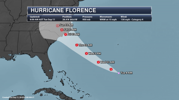
Tracking Florence. Florence is expected to restrengthen later today, and is expected to remain a dangerous major hurricane through Thursday Night as it approaches the Mid-Atlantic coast. During this restrengthening period over the next 24-36 hours, Florence could approach (if not achieve) Category 5 strength before slight weakening before landfall. Landfall is currently expected Thursday Night or early Friday along the North Carolina coast, potentially near Jacksonville. A concerning aspect about Florence is that this system is expected to quickly lose forward speed as the system approaches and moves across the Eastern United States, which would potentially lead to a very heavy rain event in the Mid-Atlantic from this system.
Numerous impacts across parts of the Eastern United States – especially in the Mid-Atlantic – are expected from Florence. These threats include dangerous storm surge at the coast, inland heavy rain and flooding, and damaging winds topping hurricane force across areas under a Hurricane Watch. Facilities along the East Coast – especially across the Carolinas and Mid-Atlantic – should make sure contingency/hurricane plans are rushed to completion over the next couple days. Conditions are likely to worsen across this region as we head into Wednesday night and Thursday.
Local Weather Service Offices have issued statements on what to expected from Florence – you can find those here: https://www.nhc.noaa.gov/text/refresh/index_hls1+shtml/111230.shtml
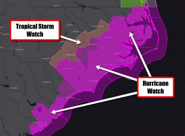
Tropical Alerts. Hurricane and Tropical Storm Watches are now in place due to Florence across parts of North and South Carolina. Locations under the Hurricane Watch include Hatteras, Greenville, New Bern, Jacksonville, and Wilmington (NC) and Myrtle Beach and Charleston (SC). Areas under the Tropical Storm Watch include Fayetteville, NC. Along the coast, Hurricane Watches are in effect from Edisto Beach South Carolina to the North Carolina-Virginia border including Albemarle and Pamlico Sounds.
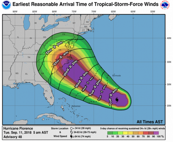
Potential Earliest Tropical Storm Force Winds. Tropical storm force winds will approach the East Coast Wednesday night, with stronger winds following Thursday into Thursday Night. By this time frame, most preparations should be completed, as these winds will impact any last minute preparations. As winds increase across the region where Florence approaches the coast, power outages and downed trees will be likely.
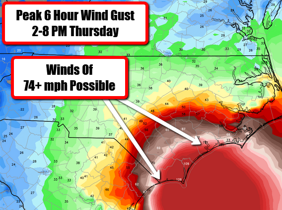
Hurricane-Force Wind Gusts Possible At Landfall. Major hurricane wind gusts can be expected in and around the area of landfall Thursday night into early Friday. According to this model, winds of over 100 mph may be possible especially in coastal areas near and along the path of Florence. These winds would be capable of knocking out power to the region, as well as downing trees and power lines.
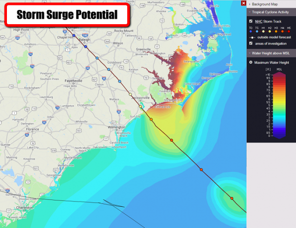
Storm Surge Potential. As Florence approaches the coast Thursday into Friday, a destructive, life-threatening storm surge will be possible, especially at high tide. Storm surge flooding occurs when rising waters move inland, causing normally dry areas to be flooded. In some coastal areas of North Carolina, a storm surge of 5-12+ feet will be possible. Here are forecast storm surge heights according to the NHC:
- Edisto Beach to Murrells Inlet…2-4 ft
- Murrells Inlet to Cape Fear…4-6 ft
- Cape Fear to Cape Lookout including The Neuse and Pamlico River…6-12 ft
- Cape Lookout to Ocracoke Inlet…5-8 ft
- Ocracoke Inlet to North Carolina/Virginia Border…3-5 ft
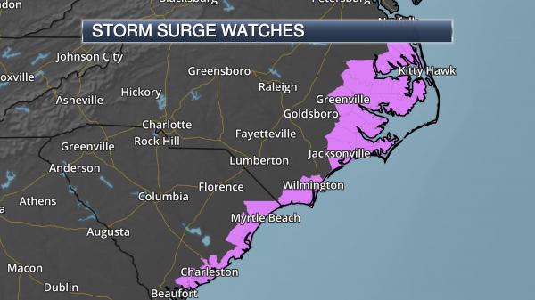
Storm Surge Watches. Due to the potential of a destructive storm surge associated with Florence, Storm Surge Watches have been issued for parts of coastal North and South Carolina. These are in effect from Edisto Beach South Carolina to the North Carolina-Virginia border, including Albemarle and Pamlico Sounds and the Neuse and Pamlico Rivers.
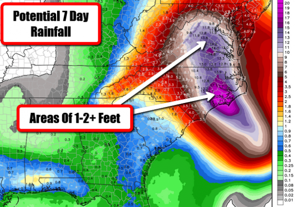
Flooding Rains Likely. Florence will produce heavy rain along the coast as well as inland near the track of the system, especially as the system slows down. In some areas, this rain could last for days due to the expected slow movement of Florence. Rainfall totals could easily top one to two feet, with isolated 30” totals, near the track of Florence across parts of the Carolinas and Virginia. This heavy rain could cause life-threatening and disastrous flooding. Areas that could see at least 6” of rain from Florence include Wilmington, Raleigh, Greenville (NC), Richmond, Charlottesville, and Lynchburg (VA), and Washington D.C.
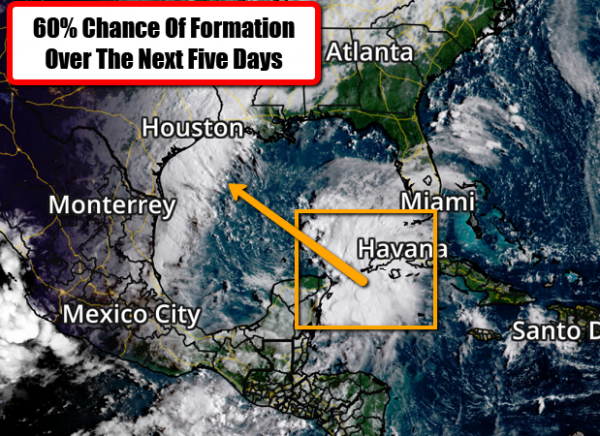
Potential Formation In The Gulf? We’re also tracking an area across the northwestern Caribbean that, while showing some organization, does not have a surface low. As this disturbed weather moves into the Gulf of Mexico late this week, however, conditions are expected to become more favorable for tropical formation, with a tropical depression possible. Right now there is about a 30% of formation in the next two days, and 60% over the next five days. This system will be worth keeping an eye on over the next several days for facilities along the Texas and Louisiana coasts.
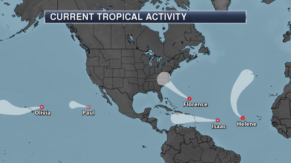
Busy In The Tropics. We are also tracking several other systems both the Atlantic and Pacific basins. Quickly looking at these systems:
- Hurricane Helene continues to move northward over the eastern Atlantic. This system will approach the Azores late this weekend.
- Tropical Storm Isaac continues to move west across the central Atlantic, and could strengthen back into a hurricane. This system could impact the Lesser Antilles later this week at or near hurricane strength.
- Tropical Storm Olivia will start to impact Hawaii later today, crossing over the islands over the next couple days. I’ll have more on this storm below.
- Paul is expected to become a remnant low later this week, and is not a threat to land.
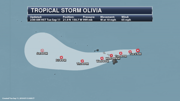
Tracking Olivia. Out in the Central Pacific, Olivia continues to move west this morning but has weakened into a Tropical Storm. As of the 2 AM HST update, Olivia had sustained winds of 65 mph and was moving to the west at 10 mph. The center of the storm was located 320 miles east-northeast of Hilo. This system will start to move more to the west-southwest later today, moving across the Hawaii Islands Tuesday Night or Wednesday. While Olivia will gradually weaken over the next 48 hours, it will remain a tropical storm as it moves over Hawaii.
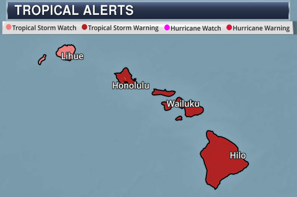
Tropical Alerts. With Olivia tracking directly over the Hawaiian Islands over the next couple days, Tropical Storm Watches and Warnings have been issued. Tropical Storm Warnings are in effect for the Big Island, Maui County, and Oahu, with a Tropical Storm Watch for Kauai. Tropical storm conditions will be possible across the Big Island and Maui County starting later today, across Oahu tonight, and in Kauai County Wednesday afternoon.
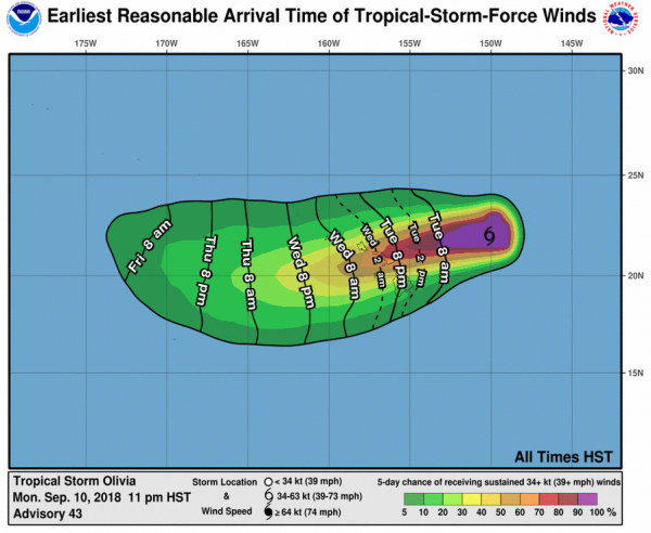
Potential Earliest Tropical Storm Force Winds. As Olivia tracks closer to Hawaii, tropical storm force winds are possible starting later today and tonight across the islands. These winds would start to disrupt preparations ahead of the storm.

Olivia Potential Wind Gusts. Some of the strongest wind gusts across the Hawaiian Islands are expected Tuesday night into Wednesday, with gusts approaching hurricane force (74 mph) possible tomorrow in both Honolulu and Kahului. The greatest potential for strong tropical storm force winds (58-73 mph) will be across Maui County, far southeastern Oahu, and parts of the northern Big Island. Winds will start to decrease across the islands by Wednesday Night as Olivia continues to push to the southeast.
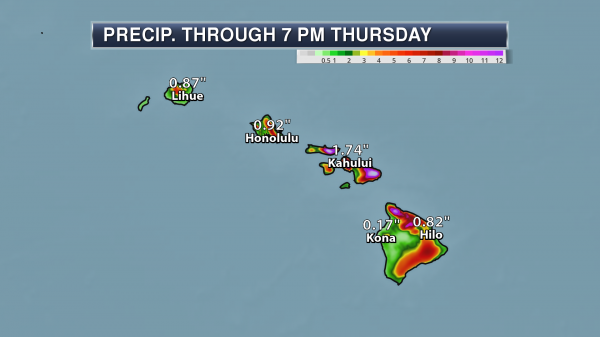
Rainfall Potential. The potential exists for 10-20” of rain, especially in windward sides of Maui and the Big Island. This heavy rain could cause flash flooding across this region.
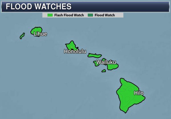
Flash Flood Watches. Due to heavy rain expected from Olivia, Flash Flood Watches have been issued for all the Hawaiian Islands from Tuesday evening through late Thursday Night. The Honolulu office of the National Weather Service notes that, “Rain events of this size can cause widespread flooding and can affect areas that do not usually flood. Low spots in roads will become dangerous and impassable due to severe runoff. Debris in streams and gulches may clog bridges and culverts resulting in dangerous flooding. Numerous landslides are expected, especially along the Hana Highway on Maui and the Mamalahoa Highway on the Big Island.”
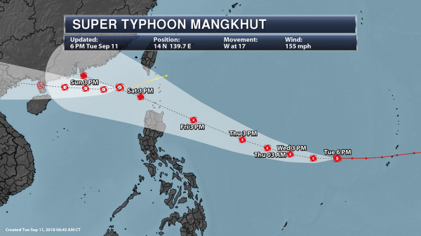
Tracking Mangkhut. Further out into the western Pacific, Mangkhut is now a Super Typhoon, but has pushed away from Mariana Islands and Guam. As of the 6 PM local time update, Mangkhut was moving to the west at 17 mph with 155 mph winds. Mangkhut will continue to move west into early Wednesday before turning to the west-northwest. This path would bring Mangkhut toward Southeast Asia, including Taiwan, late in the week into the weekend.
D.J. Kayser, Meteorologist, Praedictix