
In light of the risk Florence poses to the U.S., we’re publicly releasing our morning briefings on our blog. Check back daily for more updates. We are also providing a small sampling of our tropical weather graphics as we continue to track Hurricane Florence in the Atlantic.
Praedictix Briefing: Friday morning, September 14th, 2018
- Hurricane Florence made landfall earlier this morning as a Category 1 hurricane near Wrightsville Beach, NC, with winds of 90 mph. However, wind gusts up to 105 mph have been reported this morning in Wilmington and Fort Macon, NC. This wind has helped knock power out to over a half a million customers across the Carolinas.
- Storm surge and freshwater flooding has also been occurring due to Florence. Over 10-12” of rain has fallen across parts of coastal North Carolina, and at least 200 people have had to be rescued overnight in the New Bern, NC, area due to storm surge flooding. Numerous Flash Flood Warnings are in effect, and a Flash Flood Emergency is in place across parts of Carteret, Craven, Pamlico, and Jones Counties in North Carolina until 1 PM.
- Even though this storm has made landfall, it will remain a dangerous storm into the weekend across the region. Florence will continue to slowly move west to west-southwest through Saturday, continuing to lash portions of North and South Carolina through the weekend with gusty winds, heavy rain which could lead to catastrophic flooding, and dangerous storm surge along the coast and in some inland rivers near the coast.
- While an area of disturbed weather in the Gulf of Mexico does not look like it will form into a tropical system before it moves into Texas later today, heavy rain and occasional gusty winds will be possible across southern Texas into Saturday. Flash Flood Watches are in effect.
- Super Typhoon Mangkhut will have impacts across parts of southeastern Asia into the weekend.

Florence Has Made Landfall. The National Hurricane Center reported that Florence officially made landfall at 7:15 AM this morning near Wrightsville Beach, NC. At that time, Florence had estimated sustained winds of 90 mph. Around the time of landfall, Wilmington, NC, saw a wind gust of 105 mph. Even though Florence has made landfall, this system remains a strong and dangerous system which will continue to bring major rainfall and life-threatening storm surge across the Carolinas as well as strong, gusty winds.
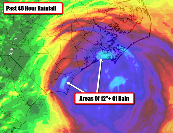
Rainfall So Far. Radar indicates that over a foot of rain has fallen so far in association with Florence in parts of coastal North Carolina. This heavy rain is leading to flash flooding across the region. Top rainfall totals through 4 AM in North Carolina include:
- 10.89” – Sneads Ferry
- 10.30” – Wrightsville Beach
- 10.10” – Oriental Town Pier
- 8.79” – Cedar Island Ferry Terminal
- 8.70” – Surf City
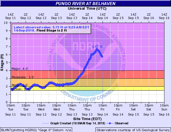
Storm Surge Flooding. Major storm surge flooding is also occurring along the coast and inland rivers due to Florence, with the Pungo River reaching a height overnight of 6.67 feet. As the Neuse and Trent rivers rose last night in the New Bern area at least 200 people had to be rescued. Additional storm surge flooding is likely across the region later today, especially around the next high tide early this afternoon.

Flash Flood Warnings And Emergencies. Due to the very heavy rain across the region so far in association with Florence, numerous Flash Flood Warnings have been issued. Due to heavy rain of 8-12” and storm surge flooding, a Flash Flood Emergency has been issued for parts of Carteret, Craven, Pamlico, and Jones Counties in North Carolina until 1 PM. That warning states that additional rainfall amounts of 3-6” are possible.

Peak Wind Gusts. Several wind gusts of at least 90+ mph have been reported mainly across North Carolina so far in association with Florence. Here is a list of top wind gusts so far:
- 112 mph: A buoy 30 miles southeast of New River Inlet
- 105 mph: Wilmington, NC, and Fort Macon, NC
- 97 mph: Cape Lookout, NC
- 89 mph: Near Cedar Island, NC
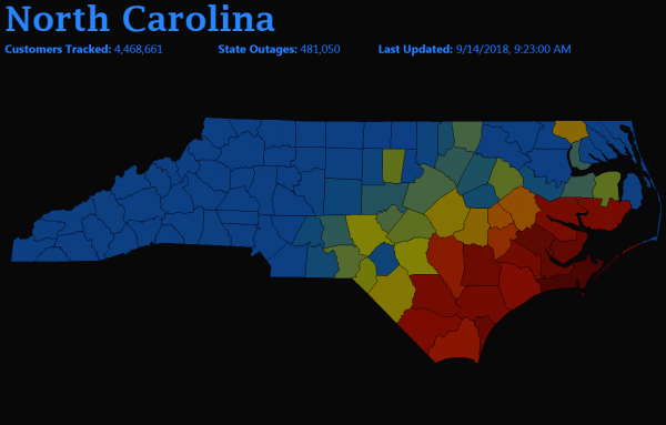
Power Outages. Due to the high winds and flooding, numerous power outages are being reported across parts of the Carolinas. As of 10:20 AM ET, over 481,000 customers in North Carolina and over 37,000 customers across South Carolina had no power. The hardest hit areas have been in western parts of North Carolina and in northeastern parts of South Carolina. You can view this map and links to local power companies at poweroutage.us.
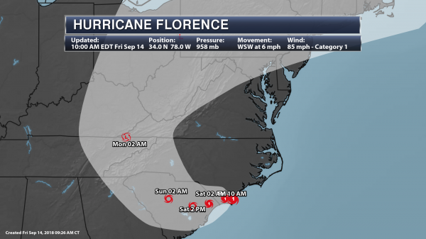
Forecast Track. Florence will slowly move west to west-southwest over through Saturday, continuing to lash portions of North and South Carolina over the next several days. Later in the weekend, Florence will start to move north across the western Carolinas and into the central Appalachian Mountains into next week. Florence will continue to weaken as this storm moves inland throughout the next several days, becoming a tropical depression by Monday morning.

Tropical Alerts. Tropical Storm and Hurricane Warnings continue to be in effect as Florence moves inland. These particularly show the potential of how far inland either tropical-storm-force (39-73 mph) or hurricane-force (74+ mph) winds will be possible. Across inland areas:
- Hurricane Warnings continue for Myrtle Beach (SC), Wilmington, Jacksonville, New Bern and Greenville (NC).
- Tropical Storm Warnings continue for Charleston and Florence (SC), Lumberton, Fayetteville, Raleigh and Rocky Mount (NC).
- Hurricane Watches are in effect for Charleston, SC.
- Tropical Storm Watches are in effect for Columbia, SC.
Along the coast:
A Hurricane Warning is in effect for…
* South Santee River South Carolina to Duck North Carolina
* Albemarle and Pamlico Sounds
A Hurricane Watch is in effect for…
* Edisto Beach South Carolina to South Santee River South Carolina

Strong Wind Gusts To Continue. Even though Florence will continue to weaken, the threat of damaging wind gusts across the Carolinas will continue over the next couple days as Florence remains a hurricane and tropical storm. Winds could still gust up to almost 100 mph in parts of southeastern North Carolina and northeastern South Carolina today and tonight. These winds will easily knock out power and down trees across the region.

Storm Surge Potential. Storm surge concerns will continue throughout the next day or so across parts of the Carolina coast, especially at high tide near and north of where the eye made landfall as onshore winds will help push water toward the shore. In some areas from Cape Fear to Ocracoke Inlet, including in inland rivers, the surge could be as high as 6-11 feet, especially if it occurs at high tide. The deepest water will occur along the coast in areas of onshore winds, where large and destructive waves will accompany the surge. Here’s a breakdown of expected storm surge levels:
Cape Fear NC to Cape Lookout NC…7-11 ft, with locally higher amounts in the Neuse, Pamlico, Pungo, and Bay Rivers
Cape Lookout NC to Ocracoke Inlet NC…6-9 ft
South Santee River SC to Cape Fear NC…4-6 ft
Ocracoke Inlet NC to Salvo NC…4-6 ft
Salvo NC to Duck NC…2-4 ft
Edisto Beach SC to South Santee River SC…2-4 ft

Storm Surge Concerns. Due to the life-threatening storm surge threat, Storm Surge Watches and Warnings continue to be in effect across parts of coastal North and South Carolina:
A Storm Surge Warning is in effect for…
* South Santee River South Carolina to Duck North Carolina
* Albemarle and Pamlico Sounds, including the Neuse and Pamlico Rivers
A Storm Surge Watch is in effect for…
* Edisto Beach South Carolina to South Santee River South Carolina

Catastrophic Flooding Possible. The other major concern we continue to worry about with Florence is heavy rain. As Florence slowly moves inland, rain will continue to dump across portions of the Mid-Atlantic, especially across areas of southwestern North Carolina and northeastern South Carolina. By the time Florence pushes out of the region, at least an additional 1-2 feet of rain could fall across these areas, leading to overall rainfall amounts of 20-40”. This heavy rain will lead to catastrophic flooding across the region and significant river flooding. Running down potential rainfall totals (via NHC):
- Southeastern coastal North Carolina into far northeastern South Carolina…an additional 20 to 25 inches, with isolated storm totals of 30 to 40 inches. This rainfall will produce catastrophic flash flooding and prolonged significant river flooding.
- Remainder of South Carolina and North Carolina into southwest Virginia…5 to 10 inches, isolated 15 inches. This rainfall will produce life-threatening flash flooding.

Flood Concerns. Numerous Flash Flood Watches remain in effect across parts of the Carolinas and Virginia due to the heavy rain potential associated with Florence.

Tornado Watch Until 5 PM ET. Landfalling tropical systems also pose the potential of producing tornadoes. Due to the potential of a few tornadoes today, a Tornado Watch has been issued for parts of eastern North Carolina (including Raleigh, Jacksonville, Greenville, New Bern, and Hatteras) until 5 PM.

Heavy Texas Rain. As an area of disturbed weather moves into Texas later today, heavy rain will be possible across southern portions of the state through Saturday. Rainfall totals of 1” to 3” will be possible over the next several days. This area of disturbed weather is what we had been watching across the Gulf Coast for potential tropical development earlier this week.

Flash Flood Watches. Due to the heavy rain threat across southern Texas, numerous Flash Flood Watches have been issued today into Saturday.

Tracking Mangkhut. Out in the western Pacific, we continue to track Super Typhoon Mangkhut. As of the 11 PM local time update, Mangkhut was moving to the west-northwest at 18 mph with 165 mph winds. The system is expected to continue in a west-northwesterly direction over the next several days. This path would bring Mangkhut toward Southeast Asia into the weekend. Right now the system looks to pass south of Tawain, more impacting parts of the northern Philippines over the next 12-24 hours local time before the center passes south and west of Hong Kong Sunday.
D.J. Kayser, Meteorologist, Praedictix