
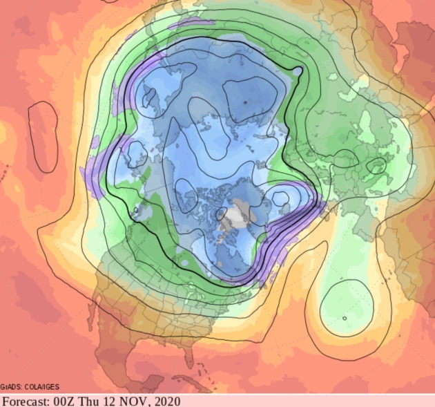
A Stretch of Indian Summer Next Week
“Lord I was born a ramblin’ man” sang the Allman Brothers. I must have been an 18-wheel truck driver in a previous life, because I love a good road trip. I just got back from a 10-day, 4200 mile trip to the east coast and back to hug my father, disconnect and stretch my legs.
I wore a mask and didn’t linger inside crowded indoor spaces – I spent most of my time outside, where it was in the 60s and 70s. I tried not to share that with loyal Star Tribune readers, who may not see the humor in warm fronts after last week’s taste of December.
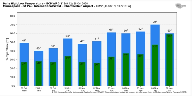
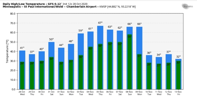
By the way, I rarely get lucky with the weather – I’m consistently disappointed by the state of the sky. So I’m thrilled to be able to report a well- timed warm front next week; an extended stretch of Indian Summer. Models are hinting at 50s, even 2-4 days above 60F, and Election Day weather should be ideal, with blue sky and highs near 60F.
I predict a dry Halloween, with Trick or Treat temperatures near 50F and a full (hunters) moon – first one on Halloween since 1944.
Scary.
Image credit: Paul Douglas


Praedictix Briefing: Issued Wednesday, October 28th, 2020:
Hurricane Zeta
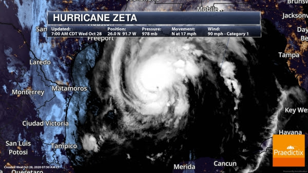
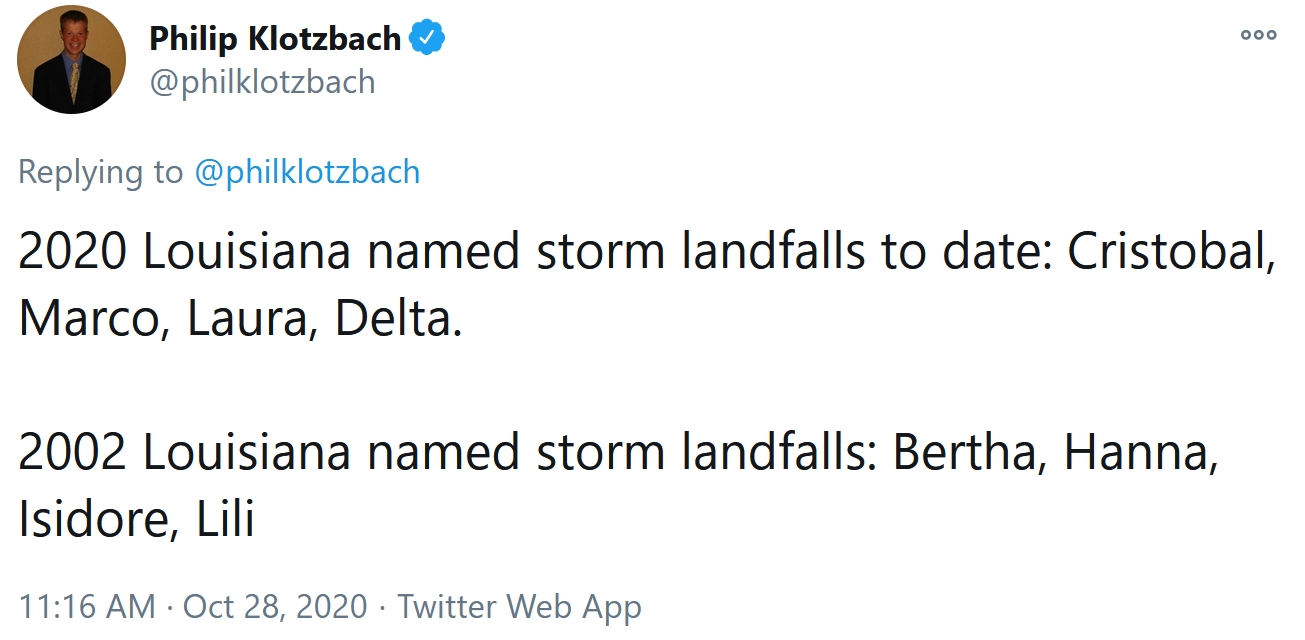
Zeta Strengthening. Zeta has been strengthening through the overnight hours, and as of 7 AM CT, Zeta had sustained winds of 90 mph, making it a Category 1 hurricane. Hurricane-force winds extend out up to 35 miles from the center with tropical-storm-force winds extending outward to 150 miles. The center of Zeta was located about 265 miles southwest of the mouth of the Mississippi River, or about 295 miles south-southwest of New Orleans, and moving north at 17 mph.
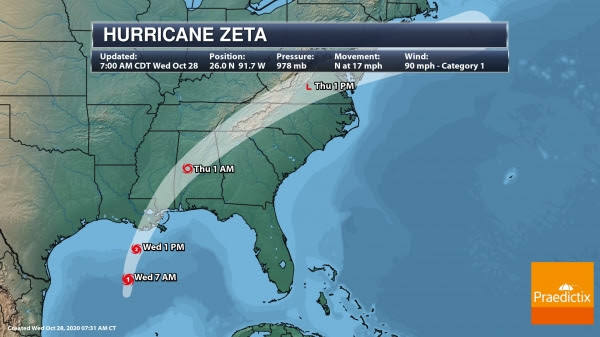
Landfall Expected Later Today. Zeta will continue to move to the north and north-northwest with an increase in forward speed today. This will bring the center of Zeta into the northern Gulf of Mexico this morning with landfall along the southeastern Louisiana coast late this afternoon or early this evening. After crossing over southeastern Louisiana, it’ll be close to the Mississippi coast later this evening and quickly move across the southeastern and eastern United States Thursday. Some additional strengthening is expected this morning, with Zeta expected to reach a peak strength of 100 mph (Category 2 hurricane) early this afternoon. After this point, we should see the strength level-off or slightly come down in the hours before landfall due to cooler waters and stronger winds aloft. However, Zeta should still be a hurricane as it approaches the Gulf Coast. Weakening will occur as it moves over land tonight into Thursday. However, given the faster forward speed of Zeta later today, we should see strong winds spreading far inland later today and tonight.
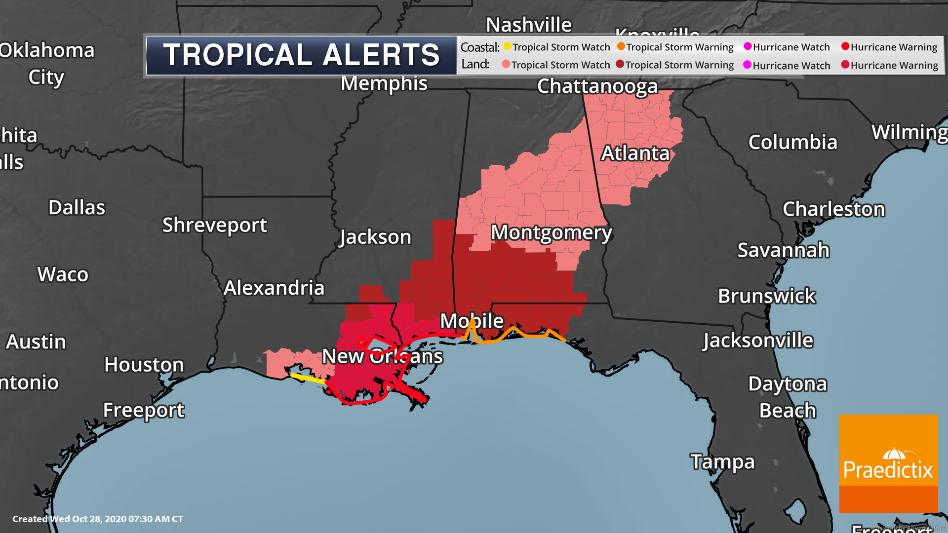
Hurricane And Tropical Storm Warnings. We continue to see Hurricane Warnings as well as Tropical Storm Watches and Warning across the central Gulf Coast stretching up to northwestern Georgia. Hurricane Warnings include New Orleans, Gulfport, and Biloxi. Tropical Storm Warnings include Hattiesburg, Meridian, Mobile, Enterprise, and Pensacola. Tropical Storm Watches include Montgomery, Birmingham, Tuscaloosa, and Atlanta. Along the coast, these watches and warnings are in place in the following locations:
Hurricane Warning: Morgan City, LA to the Mississippi/Alabama border, including Lake Pontchartrain, Lake Maurepas, and Metropolitan New Orleans
Tropical Storm Warning: Mississippi/Alabama border to Walton/Bay County Line, FL
Tropical Storm Watch: West of Morgan City to Intracoastal City, LA.
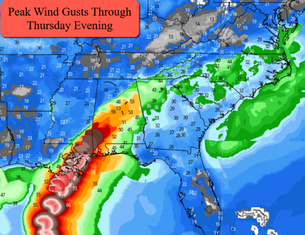
Peak Winds. The strongest winds with Zeta are expected across portions of southeastern Louisiana, particuarly in areas near where the landfall occurs, and across southern Mississippi. In these areas, wind gusts could top 80 mph. However, hurricane-force wind gusts (74+ mph) will be possible into portions of southern Alabama. Tropical-storm-force wind gusts are possible up into the Atlanta metro as we head toward early Thursday morning and across portions of the Carolinas Thursday.
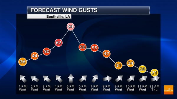
Boothville, LA, Forecast Wind Gusts. Boothville will be near where landfall could occur later today, and around that landfall late this afternoon they could see wind gusts over 80 mph. You can see the winds quickly hit and then decrease below tropical storm force by late this evening – this is thanks to the quicker forward speed expected.

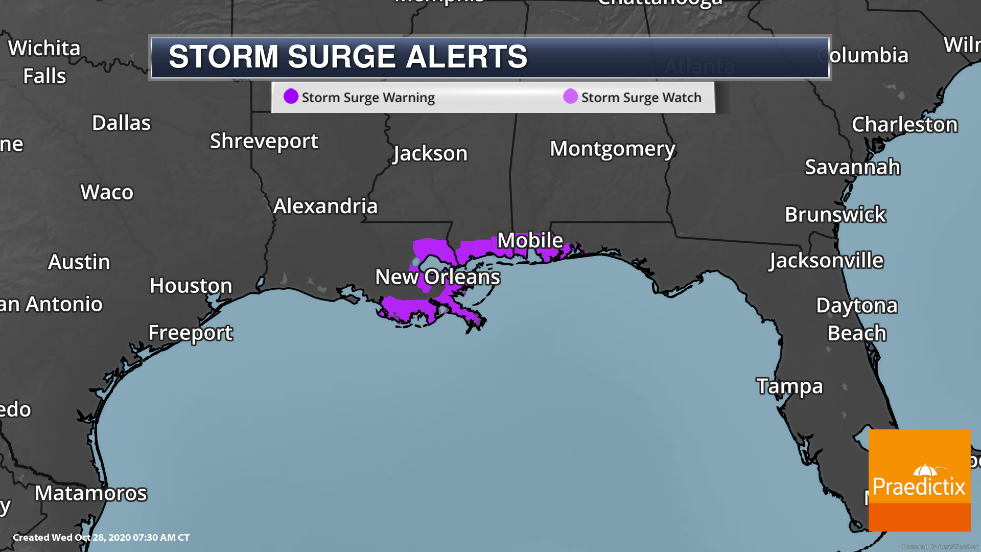
Storm Surge Concerns. A life-threatening storm surge – where normally dry areas near the coast flood due to water rushing inland – is expected with Zeta, especially if the surge of water occurs around high tide. Due to the stronger nature of Zeta around landfall, these storm surge values have increased since yesterday. The highest forecasted storm surge right now is from the mouth of the Pearl River to Dauphin Island, AL, where a peak surge of 6 to 9 feet is possible. Storm Surge Warnings are in place from the mouth of the Atchafalaya River to Navarre, FL, including Lake Borgne, Lake Pontchartrain, Pensacola Bay, and Mobile Bay.
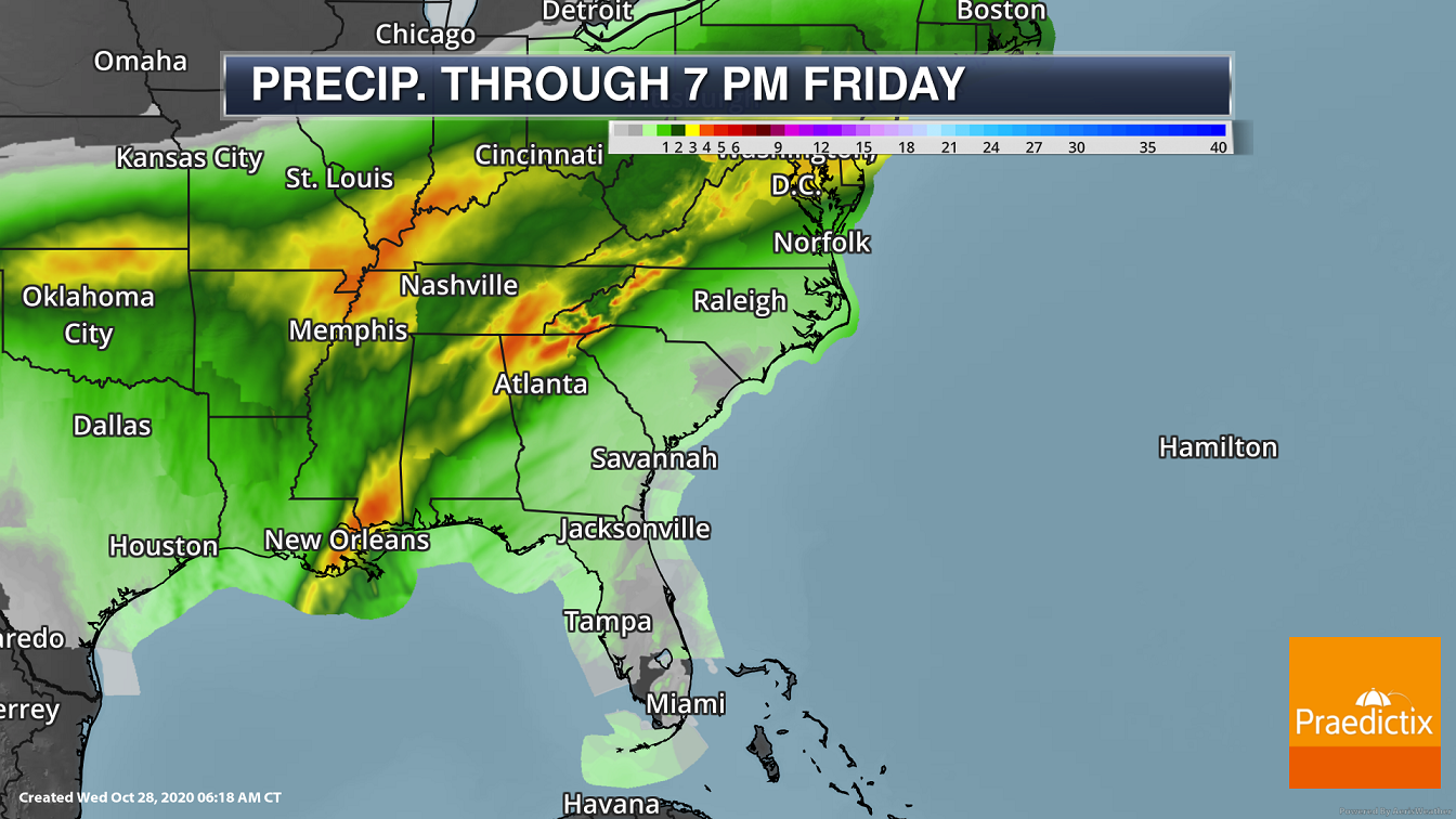

Heavy Rain Threat. Heavy rain of at least 2-4”, with isolated 6” amounts, can be expected from the central Gulf Coast to the Mid-Atlantic over the next couple of days. Some of the initial heavy rain today ahead of Zeta will move from the central Gulf Coast today to the Ohio Valley and Appalachians tonight and Thursday. That’ll be followed by the core of heavy rain with Zeta tracking from the central Gulf Coast to the Mid-Atlantic later today through Thursday. Flood Watches are in place from southeastern Louisiana to southern Virginia.
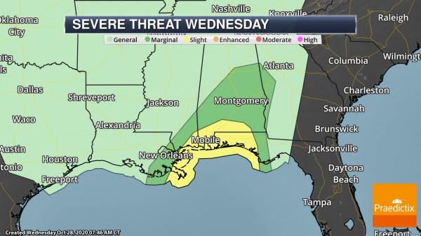
Tornado Threat. Landfalling tropical systems can also produce a tornado threat, and due to that a Slight Risk of severe weather is in place across portions of the central Gulf Coast.
Southern U.S. Snow/Ice Storm
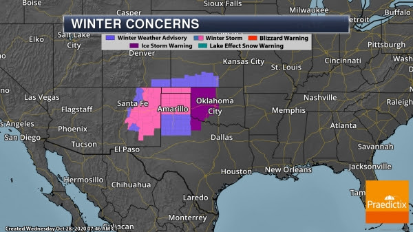
Ice And Snow. One more day of snow and ice is expected across the southern United States today, with Ice Storm Warnings continuing through 1 PM and Winter Storm Warnings into the evening hours. In areas under Ice Storm Warnings, additional ice accumulations up to around two tenths of an inch will be possible.
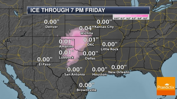
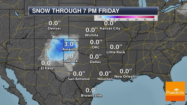
Ice And Snow Potential. Up to around two tenths or a quarter of an inch of ice will be possible in areas of the Southern Plains today, with some of the heaviest ice possible across western Oklahoma. Several inches of snow will be possible in northeastern New Mexico and the Texas Panhandle.
Fires Out West
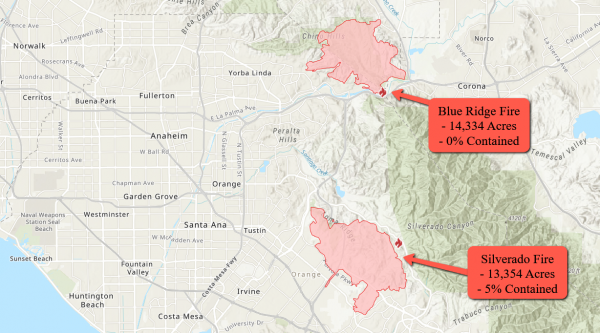
Silverado And Blue Ridge Fires. Extreme fire conditions continued across the western United States yesterday, with growth on both the Silverado and Blue Ridge Fires. Evacuations remain in place due to both fires. Get the latest on the:
- Blue Ridge Fire: https://www.fire.ca.gov/incidents/2020/10/26/blue-ridge-fire/
- Silverado Fire: https://www.fire.ca.gov/incidents/2020/10/26/silverado-fire/
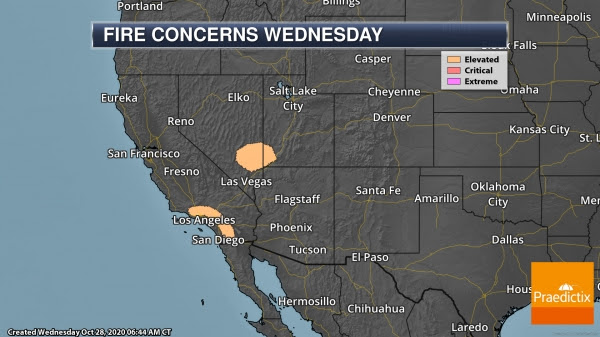
Fire Outlook Today. The good news is that no Fire Weather Warnings or Wind Advisories/High Wind Warnings are in place today as we see weaker winds across the region. However, winds of 15-25 mph along with low humidity values across portions of southern California, eastern Nevada, and southwestern Utah could still allow for fire spread across the region.
D.J. Kayser, Meteorologist, Praedictix.
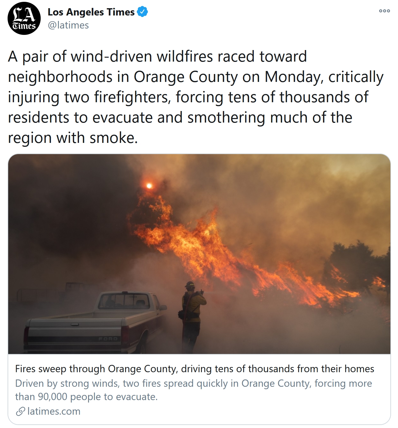
California Wildfires Force Tens of Thousands to Evacuate Orange County Amid Strong Winds. Here’s an excerpt from Capital Weather Gang: “...Winds are still expected to cause rapid fire spread and extreme fire behavior, though they’re not as strong as they were on Monday, when a gust to 96 mph was measured in Los Angeles County and gusts up to 88 mph buffeted areas near Fremont Canyon. Ontario Airport saw a gust to 70 mph, and had to shut down due to the severe crosswinds. This week’s extreme winds brought the most dangerous conditions the Los Angeles area has seen since October 2019, National Weather Service forecasters said. To raise awareness about the threat, the Weather Service office in Los Angeles called Monday’s fire weather a “Particularly Dangerous Situation” (PDS) — a label it reserves for rare events that combine wind gusts greater than 60 mph with single-digit humidity and highly flammable vegetation...”

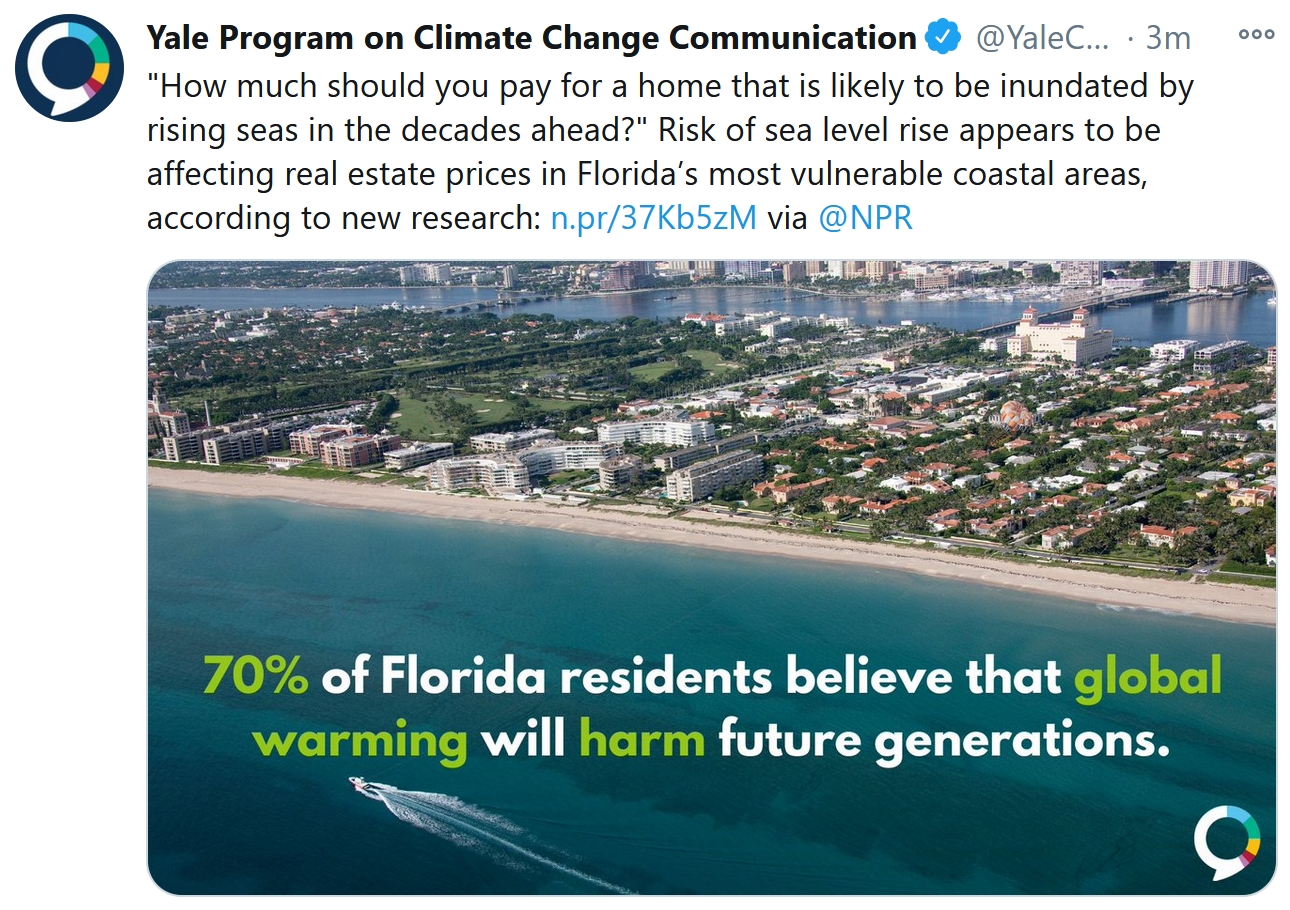
Living in Harm’s Way: Why Most Flood Risk Is Not Disclosed. NPR has a troubling story; here’s a clip: “…But no one told the Obbinks they were moving into harm’s way, because no one was obligated to: not their real estate agent, not the seller, not the inspector. Or any government agency, or the real estate website that listed the property. A growing body of research suggests that the lack of transparency and growing flood risk due to climate change are leading millions of Americans to put their safety and their financial futures in jeopardy. About 15 million properties have significant risk of flooding, according to recent estimates that take into account climate-driven weather. Yet studies in multiple states have found that most people living in harm’s way did not understand their home’s flood risk until after they purchased it…”
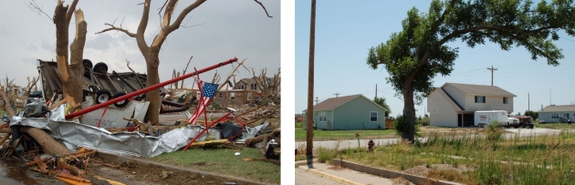
The Town That Built Back Green. It can be done, and we’ll see more of this in the years to come as communities attempt to become more storm-proof and resilient. Here’s a clip from a Washington Post article: “…A wind-swept farming community in southwestern Kansas, Greensburg rebuilt “green” after an EF5 tornado — the most violent — barreled through at more than 200 miles per hour and nearly wiped it off the map in 2007. A decade later, Greensburg draws 100 percent of its electricity from a wind farm, making it one of a handful of cities in the United States to be powered solely by renewable energy. It now has an energy-efficient school, a medical center, city hall, library and commons, museum and other buildings that save more than $200,000 a year in fuel and electricity costs, according to one federal estimate. The city saves thousands of gallons of water with low-flow toilets and drought-resistance landscaping and, in the evening, its streets glow from LED lighting…”
Photo credits: “LEFT: Main and Grant streets the day after an EF5 tornado tore through Greensburg on May 4, 2007, destroying about 95 percent of the community. RIGHT: Main and Grant streets in August 2008.”

Massive Expected Renewables Investment Still Insufficient To Limit Warming — BNEF: Headlins and links via Climate Nexus: “Renewable energy and battery storage are expected to draw at least $11 trillion of investment over the next 30 years, according to a new analysis from BloombergNEF in its annual New Energy Outlook report. Despite that enormous number, the projected increases in clean power are far behind what is required to limit global warming to less than 2°C by the end of this century — global temperatures are headed for 3.3°C of warming by 2100. BNEF also found global coal demand and carbon emissions likely peaked in 2019, due to depressed activity by the coronavirus pandemic.” (Bloomberg $, S&P Global $, TechCrunch)

Forecast: Full Moon on Halloween. Technically it’s a “Hunter’s Moon”. USA TODAY has details: “Halloween night will feature the moon event of the year. For the first time in decades, there will be a full moon visible across the entire U.S. on Halloween night, Oct. 31. The last time that a full moon was seen in all U.S. time zones on Halloween was 1944, according to the Farmers’ Almanac. The next time we’ll see an equally spooky Halloween full moon is 2039, so plan your werewolf costumes accordingly. The Halloween full moon is also known as a “blue” moon because it’s the second full moon of the month...”
File image above: NOAA.

After the Pandemic, a Revolution in Education and Work Awaits. A Thomas Friedman Op-ed at The New York Times (paywall) resonated: “…How we provide more Americans with portable health care, portable pensions and opportunities for lifelong learning to get the most out of this moment and cushion the worst is what politics needs to be about after Nov. 3 — or we’re really headed for instability. The reason the post-pandemic era will be so destructive and creative is that never have more people had access to so many cheap tools of innovation, never have more people had access to high-powered, inexpensive computing, never have more people had access to such cheap credit — virtually free money — to invent new products and services, all as so many big health, social, environmental and economic problems need solving. Put all of that together and KABOOM!...”

Coffee and Green Tea May Lower Death Risk for Some Adults. Have another cup. Big Think explains: “…Subjects who drank more than one cup of tea or coffee per day demonstrated lower odds of dying than those who had none. Those who consumed the most tea and coffee, more than four and two cups a day, respectively, enjoyed the most significant reductions in their risk of death. This level of consumption was associated with a 40 percent lower risk of death. Most interestingly, the effects of drinking tea and coffee appear to combine to reduce risk even further. Those who reported drinking two or three cups of tea a day and two or more cups of coffee were 51 percent less likely to die during the study, while those who drank a whopping four or more cups of tea and two or more cups of coffee had a 63 percent lower risk of death...”

KFC’s Fried Chicken-Scented Firelogs Available at Walmart. It’s 2020 – you can’t make this stuff up. Mental Floss explains: “The famous 11 herbs and spices recipe for Kentucky Fried Chicken (KFC) remains a closely guarded secret. But that doesn’t mean you can’t take home a firelog that will crackle with the aroma of a fresh bucket of fried chicken this holiday season. The KFC 11 Herbs and Spices Firelog ($16) has been a popular novelty purchase for the past two years, and this year, it’s available exclusively at Walmart. Made in partnership with Enviro-Log, the flammable product releases a scent reminiscent of KFC’s distinctive seasoning combination, which the company promises will last around two and a half hours while burning…”
50 F. high in the Twin Cities on Wednesday.
52 F. average MSP high on October 28.
38 F. high on October 28, 2019.
October 29, 2004: Exceptionally muggy conditions for October are felt over much of the state. Dew points surged into the middle to upper 60’s over central and southern Minnesota. Ladybugs are extremely active.
October 29, 1955: Early snow hits the Twin Cities, accumulating to 2.2 inches.
October 29, 1905: Several inches of snowfall accumulate in south central Minnesota. Snow totals included 7 inches at Fairmont, 6 inches at Farmington, 4.5 inches at Montevideo, 4 inches at Faribault, and 3 inches at New London.

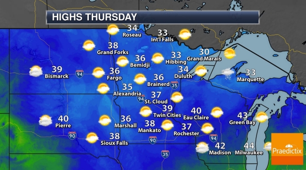
THURSDAY: Partly sunny, brisk. Winds: N 5-10. High: 37
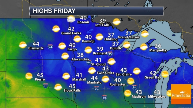
FRIDAY: Early flakes? Mostly cloudy. Winds: SE 7-12. Wake-up: 28. High: 42
HALLOWEEN: Some sun, breezy and dry. Winds: W 15-25. Wake-up: 34. High: 53
SUNDAY: Partly sunny, gusty and colder. Winds: NW 15-30. Wake-up: 30. High: 39
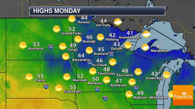
MONDAY: Plenty of sunshine, getting better. Winds: S 7-12. Wake-up: 31. High: near 50
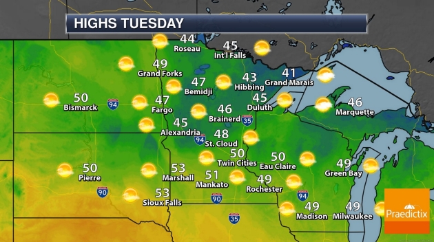
ELECTION DAY: Indian Summer. Lukewarm sunshine. Wake-up: 38. High: near 60
WEDNESDAY: Feels like September. Blue sky. Winds: W 7-12. Wake-up: 43. High: 62
Climate Stories…
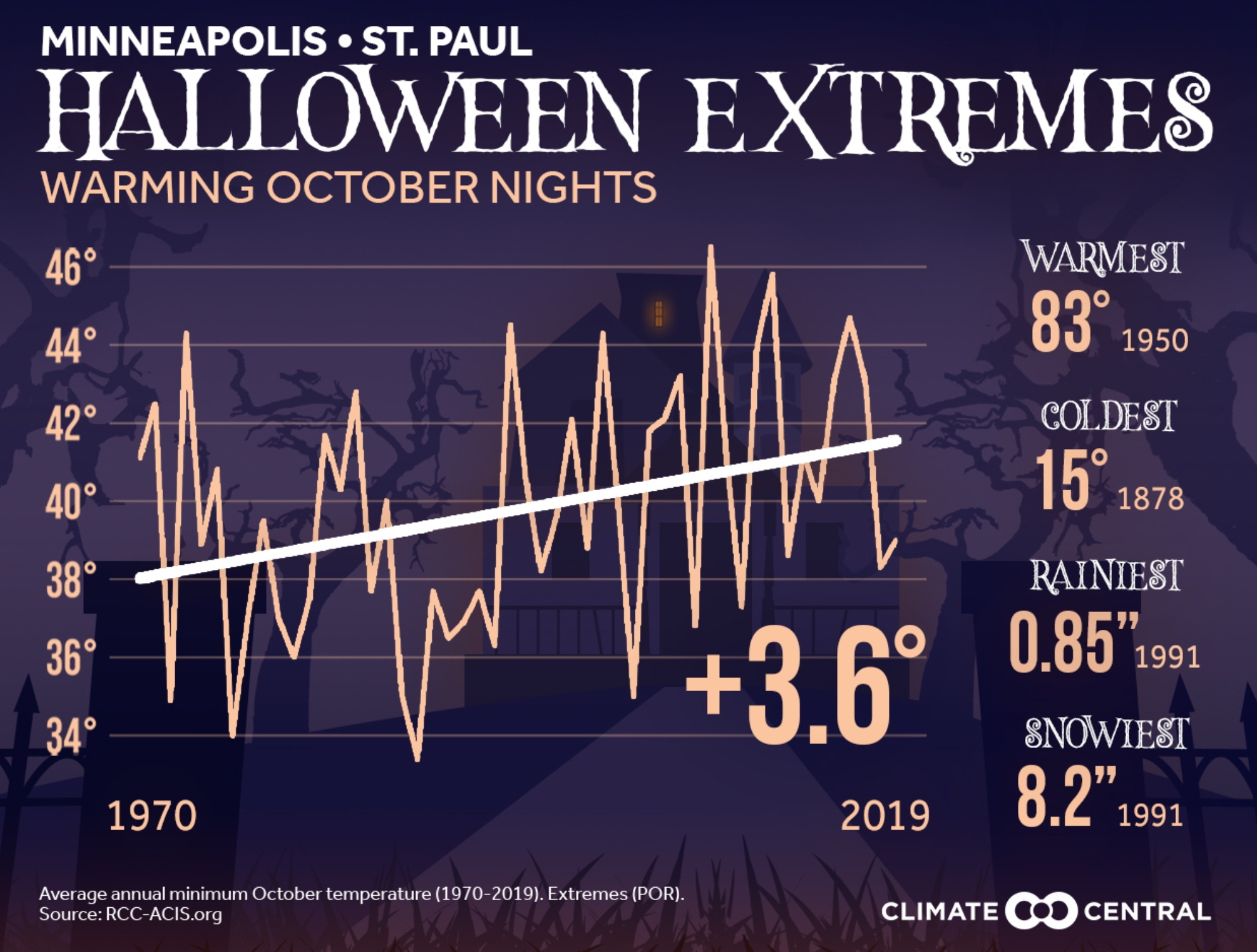
Warming Halloweens. Climate Central looks at the trends: “With Halloween a couple days away, Climate Central examines Halloween extremes—the coldest, warmest, rainiest, and snowiest October 31sts’ on record for 242 cities—as well as the warming trend of October nights. From 1970 to 2019, 88% (212) of the 242 cities analyzed had an increase in their October minimum temperatures, consistent with the overall fall warming trend caused by climate change. Traditional October and fall festivities, like trick-or-treating and pumpkin picking, may undergo some changes as our climate warms. Increased global temperatures can help amplify wet and dry conditions regionally, and as a result, threaten cocoa bean and pumpkin harvests…”

Warming Climate and Arctic Sea Ice in a Veritable Suicide Pact. Yale Climate Connections found a clever (and vaguely terrifying) way to work “suicide” into a climate headline. But the situation up north is, in fact, dire. Here’s an excerpt of their reporting: “Think of it as a suicide pact on ice – global warming and Arctic sea ice in a mutually destructive relationship. Earth’s rising temperatures melt Arctic snow and ice, which, as the reflective surface cover disappears, reveals the dark land and ocean surface beneath. That darkening surface causes the Arctic to absorb more sunlight and therefore to warm faster … which in turn leads to more melting of snow and ice, ergo resulting in more warming. Scientists refer to Earth’s surface reflectivity as its “albedo,” and to the vicious Arctic melting-warming cycle as a “feedback.” One action precipitates and reinforces another, in this case with Arctic warming and ice loss each accelerating the other. As a result, the Arctic is warming three times faster than the global average and its sea ice is quickly melting away. In summers between 1979 and 2012, Arctic sea ice had lost half its surface area and three-quarters of its volume. Some climate scientists described this rapid decline as the “Arctic sea ice death spiral...”
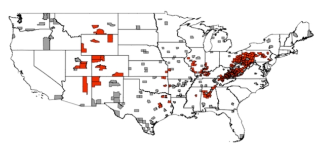
The Secret Political Power of Fossil Fuels. Every industry eventually gets disrupted as new technologies emerge. We have a word for that. Progress. Here’s the intro to a post at The Atlantic: “In a new working paper, they find that the backlash to lost coal jobs added tens of thousands of votes to Trump’s ledger in 2016. Their analysis bodes ill for Democrats—and it matters now, as former Vice President Joe Biden tries to retake Pennsylvania after Trump’s victory there four years ago. The team began by looking at more than 300 rural counties across the country—half with coal mines or power plants, half without. From 1992 to 2008, you could not distinguish the coal counties from the non-coal counties by comparing how they voted. Then cheap renewables and natural gas started flooding the power market, and coal jobs began to vanish. Suddenly, the Republican vote skyrocketed in the counties with coal plants—specifically those that lost jobs…”
Map credit: “Red counties saw a coal-related Republican surge, while gray counties did not.” (Egli, et al.)
Political Appointees Install Climate Deniers, Tighten Grip On NOAA Science: Climate Nexus has headlines and links: “Political appointees at the National Oceanic and Atmospheric Administration, including some who deny the scientific consensus of climate change, have taken dramatic steps to clamp down on scientific communications at the agency, the New York Times reports. Last month, NOAA chief scientist Craig McLean was fired the day after circulating the agency’s policy on scientific integrity to new political appointees. McLean was replaced by Ryan Maue, previously of the Cato Institute, who has downplayed climate change. Around the same time, David Legates, who denies humans’ role in causing climate change, was appointed to the brand new position of deputy assistant secretary. Both hirings were made without the involvement of NOAA administrator Neil Jacobs — who under the new rules imposed by the administration’s political appointees — is prohibited from sending emails to his own staff without first clearing it with political appointees. The new rules also include mandatory approval by Trump-appointed political staff of all internal and external communications, meaning all social media posts, news releases, and even agency wide emails from career scientists. The administration’s goal appears to be to undercut the National Climate Assessment, in order to ultimately weaken the endangerment finding — the 2009 scientific assessment by EPA that greenhouse gas pollution endangers public health.” (New York Times $)

As Election Nears, Trump Makes a Final Push Against Climate Science. The New York Times (paywall) reports: “The Trump administration has recently removed the chief scientist at the National Oceanic and Atmospheric Administration, the nation’s premier scientific agency, installed new political staff who have questioned accepted facts about climate change and imposed stricter controls on communications at the agency.The moves threaten to stifle a major source of objective United States government information about climate change that underpins federal rules on greenhouse gas emissions. One of the early signs of the shift came last month, when Erik Noble, a former White House policy adviser who had just been appointed NOAA’s chief of staff, removed Craig McLean, the agency’s acting chief scientist...”
Top NOAA Scientist Fired After Asking Trump Appointees to Acknowledge Agency Scientific Integrity Policy. Daily Beast has the story.
Key Player in War on Climate Change? The Pentagon. CNN.com has an Op-Ed that shows how the military can lead the way on clean, sustainable (more battle-resistant) forms of energy. In fact it’s already happening: “…What’s more, as one of the world’s largest and most complex institutions, the Department of Defense can be part of the climate solution. To its credit, the DoD has already been investing over $1.5 billion of its annual research and development budget in new energy technologies. In the past, it has played a significant role in developing nuclear reactors, gas turbines and solar photovoltaic cells. In the future, the DoD could help accelerate the development of dual-use green technologies, from cleaner jet fuels, which alone account for more than 50% of DoD’s energy consumption, to compact nuclear fusion, fuel cells, better batteries, microgrids and storage technologies…”
Image credit: CNN.

GM and Ford New About Climate Change 50 Years Ago, Energy Trade Publication Has Uncovered. I’m shocked. MarketWatch has the story: “Scientists at two of America’s major automakers knew as early as the 1960s that car and truck emissions caused climate change, but internal research was stifled while funding to undermine environmental causes persisted, a months-long investigation by energy trade publication E&E News has found. The environmental data kicked up the ranks inside General Motors Corp. and Ford Motor Co. instead was parlayed into decades of political lobbying by the two car giants that undermined global attempts to reduce heat-trapping emissions. The two automakers in recent months joined a wave of corporations in setting zero-emissions target dates in the coming decades, while embracing rising customer demand for electric vehicles…”