

Hurricane Delta Threatens Gulf Coast
“Paul, has a hurricane named after the Greek alphabet ever been retired?” According to the World Meteorological Organization (WMO) that has never happened – and no, any Greek name would be reused in the future.
Why is this even relevant? Hurricane “Delta” may deliver a devastating blow to Cancun today before curving north, coming ashore as a major (Category 3+) storm over coastal Louisiana or Texas Friday night. Many small towns in Louisiana still haven’t recovered from Hurricane Laura, which roared ashore August 26.
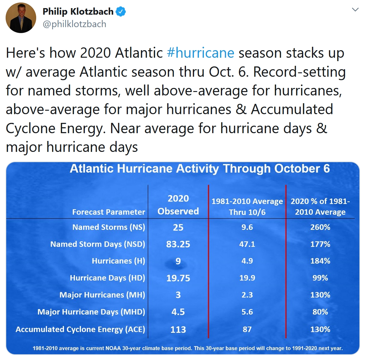
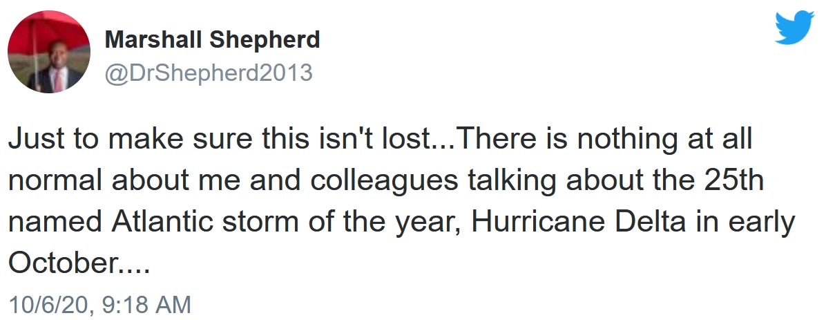
“Delta” is the 25th named storm of 2020. The all-time record is 28 named storms in 2005, the year Katrina flooded New Orleans.
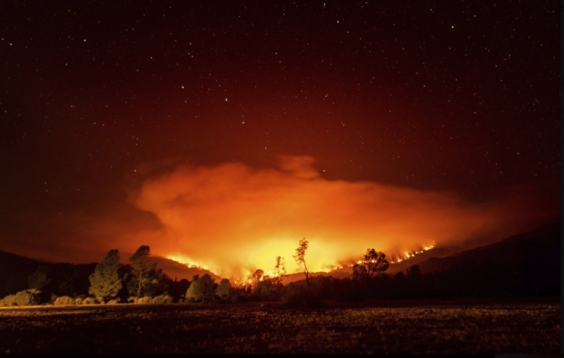
Our biggest weather risk into Sunday is wildfires; the combination of dry brush and gusty winds making for a combustible scenario.
Otherwise, our weather will be sunny and serene, with 80 degrees by Friday. The next chance of a badly needed dose of rain? Monday. Daytime highs cool into the 60s next week, much closer to average. No polar punches are imminent.
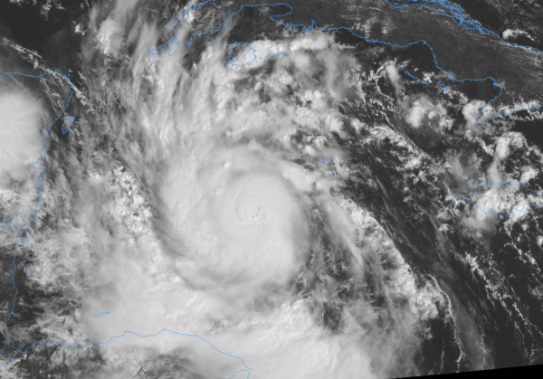
Tuesday evening satellite image credit: AerisWeather.
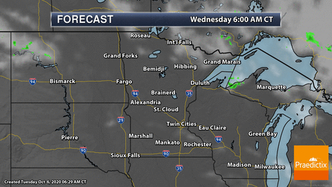

Praedictix Briefing. Issued Tuesday morning, October 6th, 2020:
Key Messages:
-
Hurricane Delta is now a MAJOR Category 3 storm with maximum sustained winds of 115 mph and is now the third major hurricane of the 2020 Atlantic hurricane season. and is located southwest of the Cayman Islands in the Caribbean.
-
Delta has undergone rapid intensification and further strengthening is expected in the next 24 hours. A Category 4 landfall in the Yucatan is expected to occur tomorrow.
-
Tropical storm conditions will begin later today and tonight in the Yucatan peninsula with hurricane conditions beginning tomorrow. Hurricane warnings are in effect for this area. Hurricane warnings are currently in effect for the northern Yucatan.
-
Hurricane Delta will impact the United States later this week with landfall projected late Friday night into early Saturday morning as a Category 2 hurricane in the Gulf Coast.
-
Widespread heavy rainfall will occur later this week in the lower Mississippi Valley into the Tennessee Valley and Kentucky.
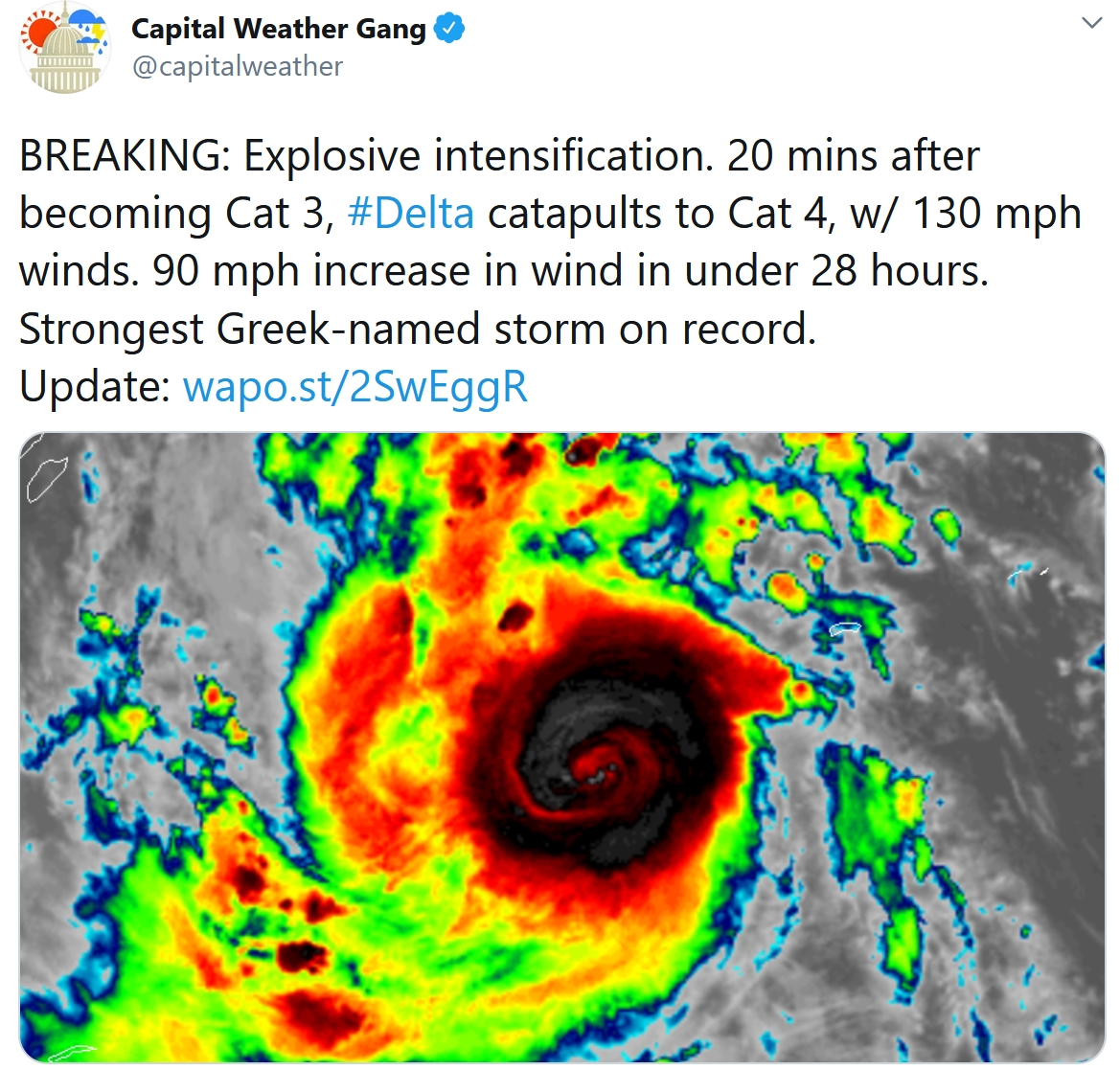
Delta Continues to Strengthen. Low wind sheer, deep moisture and very warm Caribbean waters will continue to strengthen Hurricane Delta with strengthening expected to continue until it reaches the Yucatan. The storm’s speed has increased this morning and is moving WNW at 16 mph.
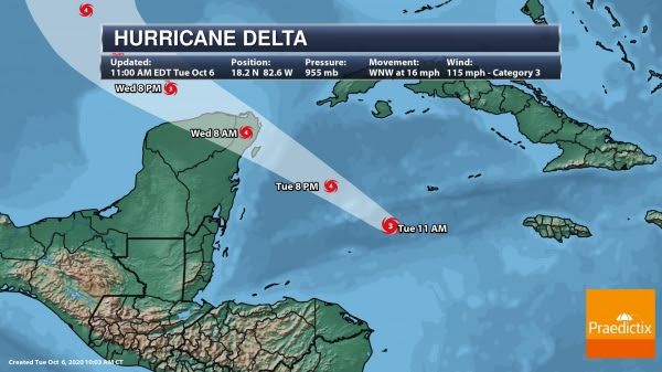
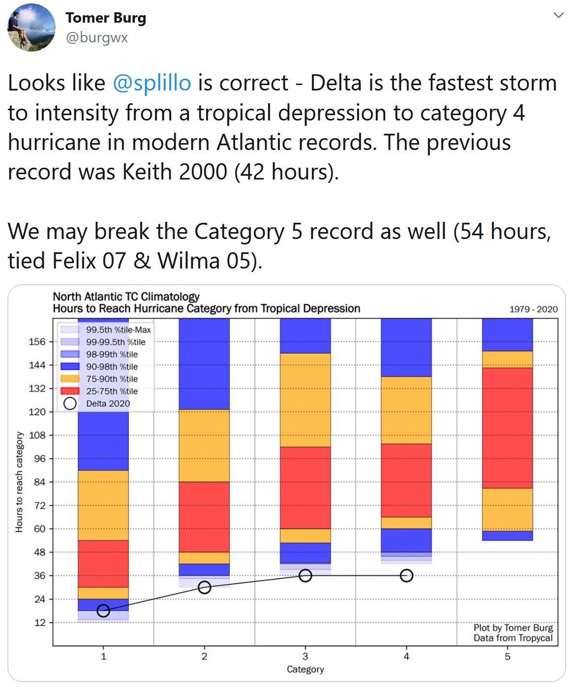
Tracking Hurricane Delta. Delta is projected to continue to move WNW today. There has been a slight westward shift in the forecast track this morning for the first 24-36 hours. A strengthening ridge is the steering mechanism of this hurricane at the moment. With further strengthening today and tomorrow, Delta is forecast to make landfall in the Yucatan (Cancun area) Wednesday as a MAJOR Category 4 hurricane. If Delta does indeed strengthen to have winds of 120 mph as the forecast suggests, it would become the strongest Greek-named hurricane in the Atlantic on record.

End-of-Week Landfall in the United States. Once Delta enters the Gulf, the hurricane is expected to slow and turn northward as a trough moves through Texas. Some fluctuation in strength is expected once it’s in the Gulf of Mexico. At the moment, the NHC is projecting a Category 2 landfall in the U.S. Gulf Coast Friday night/early Saturday morning. Note that there is significant uncertainty in Delta’s longer range track. The 4-day track error is around 150 mph with an intensity error at nearly 15 mph.
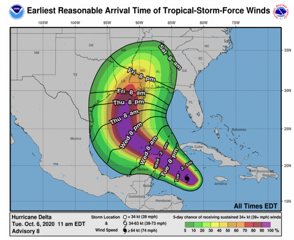
Arrival of Tropical-Storm-Force Winds. The latest forecast update from the NHC suggests the arrival of tropical-storm-force winds in the Gulf of Mexico by late Thursday evening into Friday morning. Hurricane conditions are expected as Delta tracks closer later Friday into Saturday morning. Warnings will be issued when hurricane conditions are expected within 24 to 36 hours.
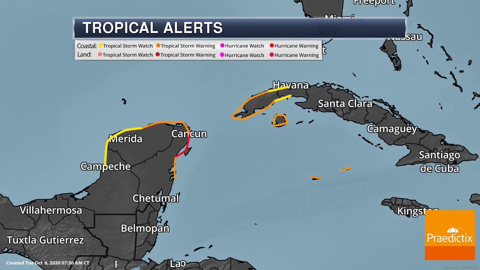
Tropical Alerts in Effect. Hurricane conditions will begin early Wednesday in the Yucatan with tropical storm conditions beginning later today or tonight. Tropical storm conditions will continue today in the Cayman Islands. Hurricane-force winds extend outward up to 25 miles from the center of Delta with tropical-storm-force winds extending outward up to 90 miles. Below is a summary of the active warnings and watches in effect:
A Hurricane Warning is in effect for…
* Tulum to Dzilam Mexico
* Cozumel
A Tropical Storm Warning is in effect for…
* Cayman Islands including Little Cayman and Cayman Brac
* Cuba province of Pinar del Rio
* Isle of Youth
* Punta Herrero to Tulum
* Dzilam to Progresso
A Tropical Storm Watch is in effect for…
* Cuba province of La Habana
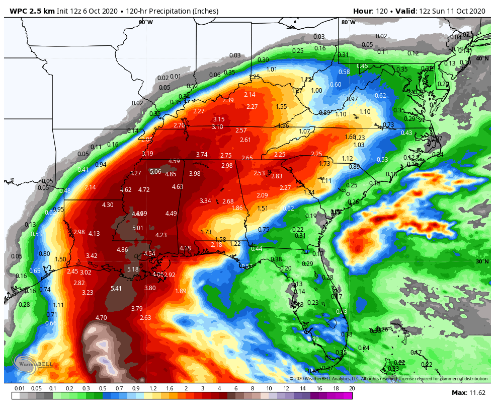
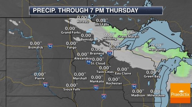
Torrential Rainfall. Hurricane Delta will produce between 4 and 6 inches of rainfall with isolated maximum totals of 10 inches across the northern Yucatan through the midweek. Significant flash flooding is expected with the threat of mudslides. In the United States, the storm is projected to bring a widespread 3 to 6 inches of rain from the lower Mississippi Valley into the Tennessee Valley and Kentucky. The higher totals will likely occur in Louisiana, Mississippi, western Alabama, southeastern Arkansas, and southwestern Tennessee.
Meteorologist Susie Martin.

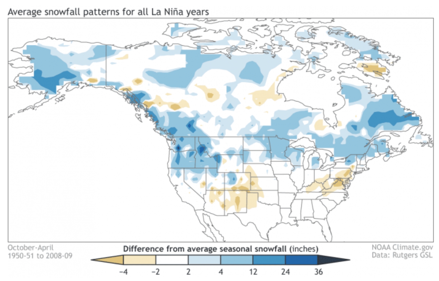
How Might La Nina Cooling Phase Impact Our Winter? Good luck with that one – models are literally all over the map. Every La Nina cold phase of the Pacific is different, but I found some interesting nuggets in a post at severe-weather.eu: “…The temperature forecast below shows much of North America in above-normal temperatures. But this might not be the best solution, also considering what the model showed on the previous image with the pressure systems. Alaska and Western Canada will be colder than normal, with a high chance of the colder air extending towards the parts of the northern United States and also with a few storms into the northeast. Europe also features higher than normal temperatures, but not to a high value. Tho a more westerly dominant scenario is likely, the pressure pattern does allow for a break in the flow, and occasional cold flow from the north into Europe, dependant on the positioning of the Atlantic high-pressure system…”
Map credit: NOAA Climate.gov.
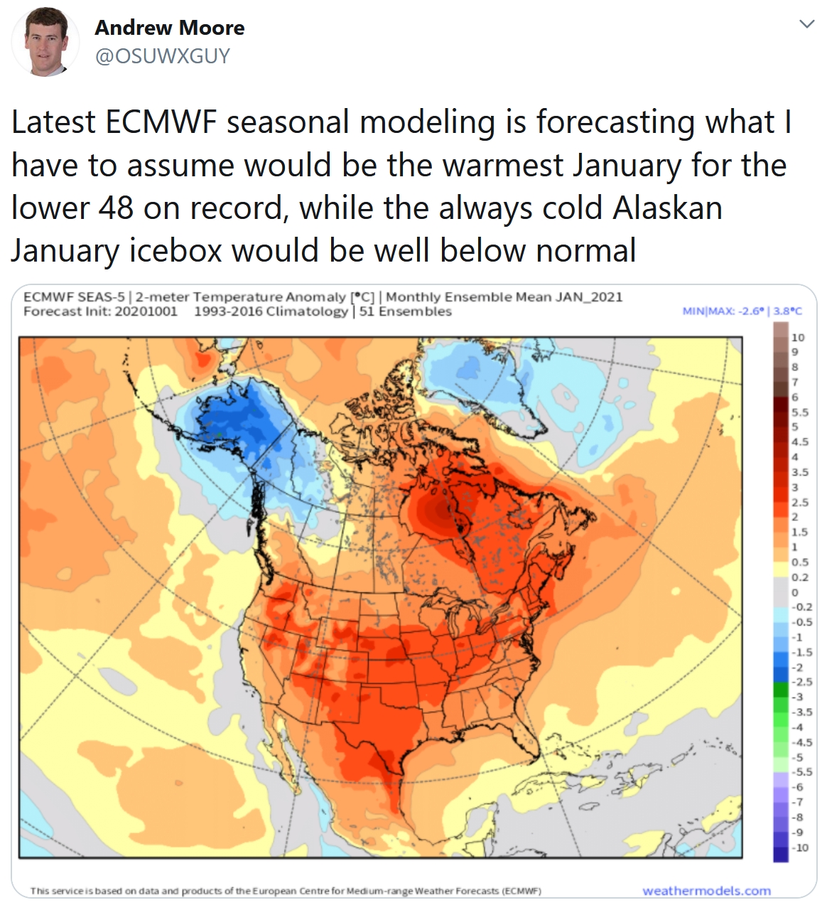
On The Other Hand. Here is ECMWF’s latest seasonal model for January, 2021. La Nina? La Schmina! We’ll see if this actually verifies.

What a Difference a Year Makes. Dr. Mark Seeley contrasts 2019 and 2020 in the latest edition of Minnesota WeatherTalk: “Last year (2019) was the wettest year in history for Minnesota with a statewide average precipitation of 35.66 inches, about 28 percent higher than the long-term annual mean for the state of 27.92 inches. I thought for perspective we could look at statistics for the first nine months (Jan-Sep) of 2020 and examine the values of precipitation. On a statewide basis the first 9 months of 2020 delivered an average of 21.21 inches, down from the first 9-months of last year which was 28.45 inches. For the year so far most climate stations in the state are reporting less than average precipitation, and some places are exceptionally dry. These include: Duluth with 15.04 inches for Jan-Sep, the 3rd driest all-time (trailing 1918 and 1934)…”
Photo credit: Chris McKelvey, Praedictix.
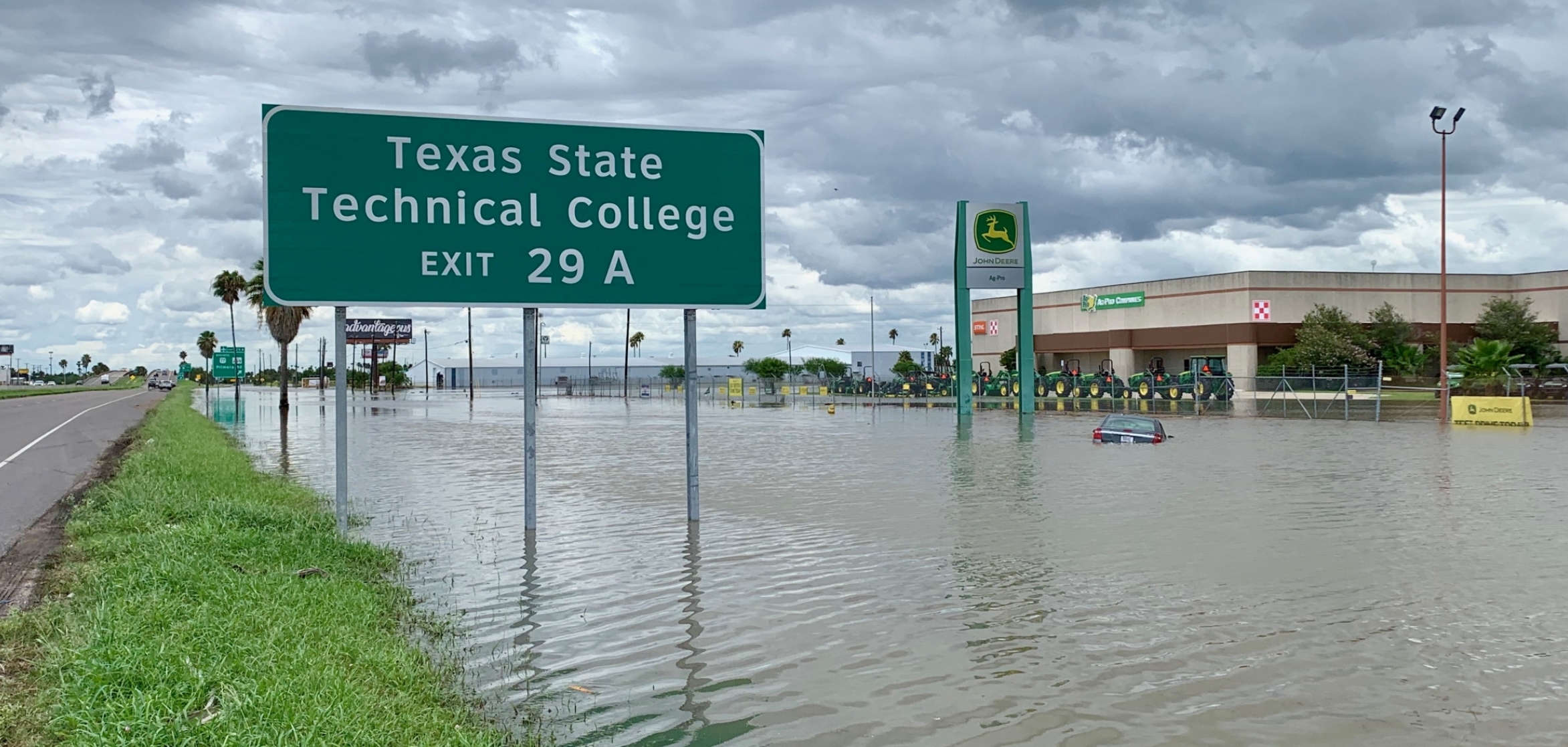
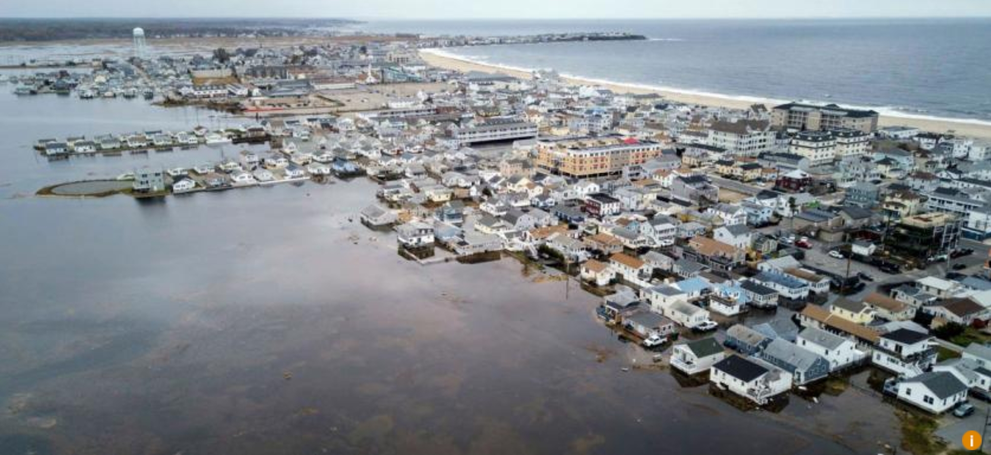
Repeatedly Flooded Properties Will Continue to Cost Taxpaers Billions of Dollars. Some interesting statistics courtesy of The Pew Charitable Trusts: “…Among the NFIP’s flaws is the way it treats repetitive loss properties (RLPs)—those that have flooded and received insurance claim payments multiple times. Unlike private insurers, the NFIP lacks the legal authority to manage costs by refusing coverage to or dramatically increasing rates for properties with excessive claims. Today, there are more than 5 million NFIP policies. Historically, RLPs comprise around 1 percent of NFIP insured properties, but over time they have accounted for more than 30% of claim payments. The NFIP has paid a cumulative $22.2 billion in claims to RLPs, an amount that surpasses the program’s total debt, according to the Government Accounting Office (GAO)...”
File photo: NOAA.

Floodgates in Venice Work in First Major Test. The New York Times (paywall) reports: “After decades of bureaucratic delays, corruption and resistance from environmental groups, sea walls designed to defend Venice from “acqua alta,” or high water, went up on Saturday, testing their ability to battle the city’s increasingly menacing floods. By 10 a.m., all 78 floodgates barricading three inlets to the Venetian lagoon had been raised, and even when the tide reached as high as four feet, water levels inside the lagoon remained steady, officials said. “There wasn’t even a puddle in St. Mark’s Square,” said Alvise Papa, the director of the Venice department that monitors high tides...”
Image credit here.
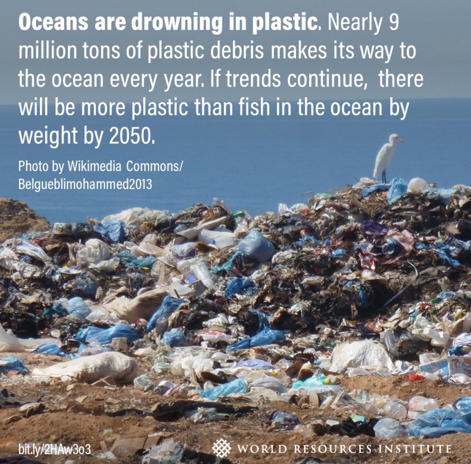
Study: 14 Million Metric Tons of Microplastics on the Ocean Floor. CNN.com has details: “But relatively little is known about the levels of plastic nestled on the sea bed and in the deep-sea sediment at the bottom of our world. A new study from Australia’s national science agency CSIRO and published in the journal Frontiers in Marine Science on Monday, has shed some light on this plastic problem, estimating that there is 14 million metric tons of microplastics sitting on the ocean floor. That’s more than 35 times as much plastic than is believed to be floating on the surface, the study suggests…”
Image credit: World Resources Institute.

Honda Lauches All-Electric Honda e. Top Gear has details: “…Honda clearly isn’t going Tesla chasing with this one, the dimensions are Fiat 500-plus-a-bit, wider than a Jazz but actually narrower when you take into account it has no wing mirrors. This is very much an urban runaround. A range of 137-miles means you won’t want to stray too far from town, but a choice of 134bhp and 152bhp versions, both with decent performance especially up to 30mph, a chassis that’s been shown some of Honda’s handling love and a configurable driving experience mean it’s not out of its depth if you fancy a ‘proper’ drive… and have the battery to spare...”

Compact Nuclear Fusion Reactor is “Very Likely to Work”, Studies Suggest. If true, this would be a breakthrough of epic proportions. Details via The New York Times (paywall): “Scientists developing a compact version of a nuclear fusion reactor have shown in a series of research papers that it should work, renewing hopes that the long-elusive goal of mimicking the way the sun produces energy might be achieved and eventually contribute to the fight against climate change. Construction of a reactor, called Sparc, which is being developed by researchers at the Massachusetts Institute of Technology and a spinoff company, Commonwealth Fusion Systems, is expected to begin next spring and take three or four years, the researchers and company officials said. Although many significant challenges remain, the company said construction would be followed by testing and, if successful, building of a power plant that could use fusion energy to generate electricity, beginning in the next decade...”
Sparc image credit: “Rendering of SPARC, a compact, high-field, DT burning tokamak, currently under design by a team from the Massachusetts Institute of Technology and Commonwealth Fusion Systems. It’s mission is to create and confine a plasma that produces net fusion energy.” CAD rendering by T. Henderson, CFS/MIT-PSFC.

Pope Francis Says Capitalism Has Failed During the Pandemic. CNN Business has the story: “Pope Francis disparaged so-called trickle-down economic theory, saying the pandemic has shown that free-market policies cannot solve all of humanity’s most dire needs. In a 70-page encyclical, the highest form of papal teaching, Pope Francis outlined his vision for a post-pandemic world. “The marketplace by itself cannot resolve every problem, however much we are asked to believe this dogma of neoliberal faith,” the pope wrote. He added that free-market capitalism “reproduces itself” by resorting to the magic theories of “spillover” or “trickle” as the only solution to societal problems…”
File image: Associated Press.
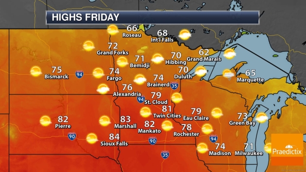
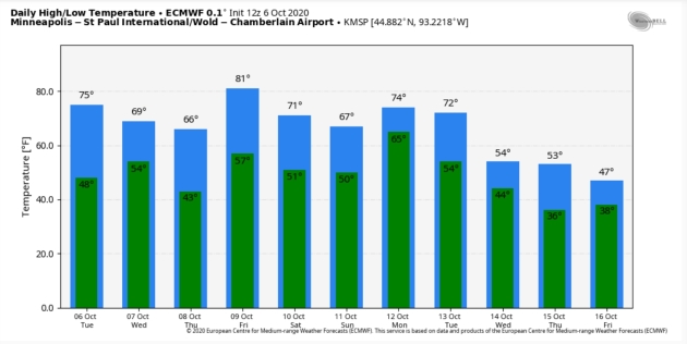
80 F. high temperature in the Twin Cities on Tuesday.
63 F. average high on October 6.
65 F. high on October 6, 2019.
October 7, 2003: Record high temperatures are seen across the area. St. Cloud’s high is 86 degrees. Minneapolis ties their record high of 85 degrees set in 1997, and Alexandria sets their record high of 88 degrees. Forest Lake reaches a record-setting 82 degrees, along with Stillwater at 84 degrees.
October 7, 1980: Summer-like heat occurs over Minnesota with highs of 92 at Montevideo and 84 at MSP airport.


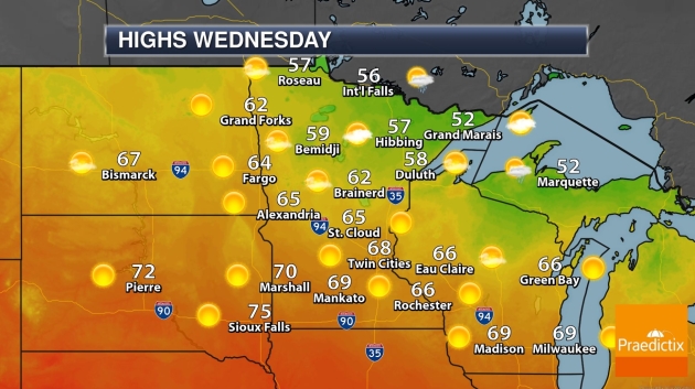
WEDNESDAY: Sunny and breezy. Winds: NW 10-15. High: 69
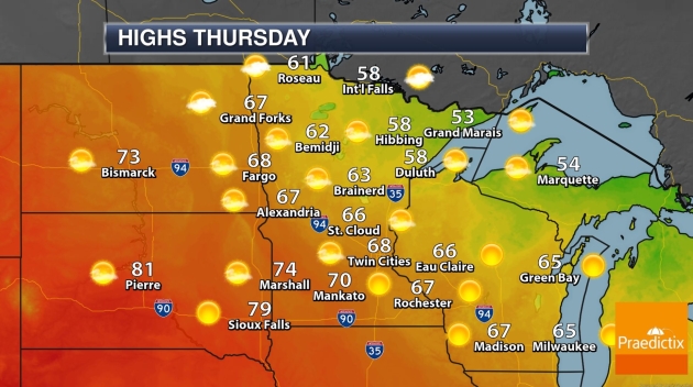
THURSDAY: Sunny and pleasant. Winds: SE 8-13. Wake-up: 44. High: 67
FRIDAY: Warm sunshine, very lake-worthy. Winds: W 10-20. Wake-up: 57. High: 81
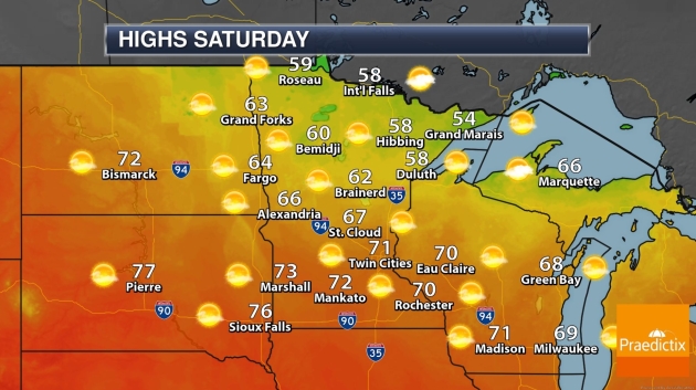
SATURDAY: Sunny and cooler – still dry. Winds: NE 7-12. Wake-up: 55. High: 72
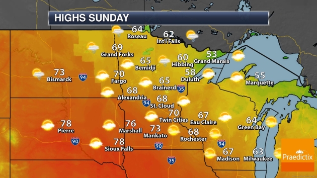
SUNDAY: Some sun, stiff southeast breeze. Winds: SE 15-30. Wake-up: 52. High: 69
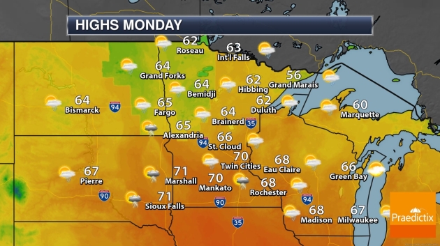
MONDAY: Showers and T-storms move in. Winds: SE 15-25. Wake-up: 59. High: 72
TUESDAY: Cooler with a stray shower. Winds: NW 10-20. Wake-up: 53. High: 63
Climate Stories…
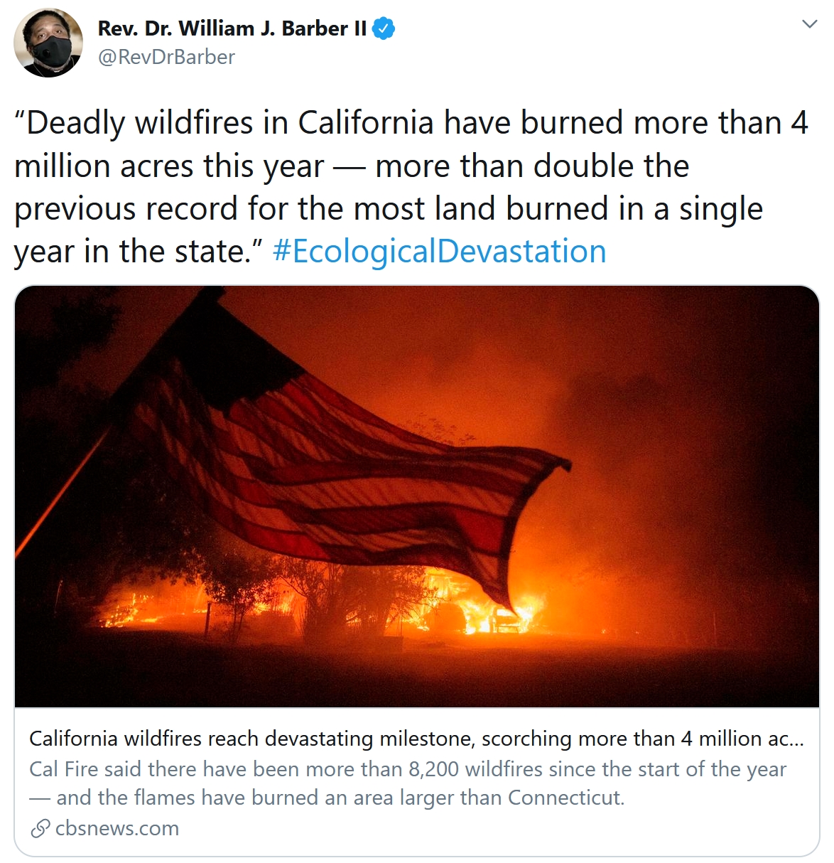
Climate Change is Increasing the Likelihood of Extreme Autumn Wildfire Conditions Across California. Here’s an excerpt of an abstract at IOPscience: “…We show that state-wide increases in autumn temperature (~1 °C) and decreases in autumn precipitation (~30%) over the past four decades have contributed to increases in aggregate fire weather indices (+20%). As a result, the observed frequency of autumn days with extreme (95th percentile) fire weather—which we show are preferentially associated with extreme autumn wildfires—has more than doubled in California since the early 1980s. We further find an increase in the climate model-estimated probability of these extreme autumn conditions since ~1950, including a long-term trend toward increased same-season co-occurrence of extreme fire weather conditions in northern and southern California. Our climate model analyses suggest that continued climate change will further amplify the number of days with extreme fire weather by the end of this century, though a pathway consistent with the UN Paris commitments would substantially curb that increase…”
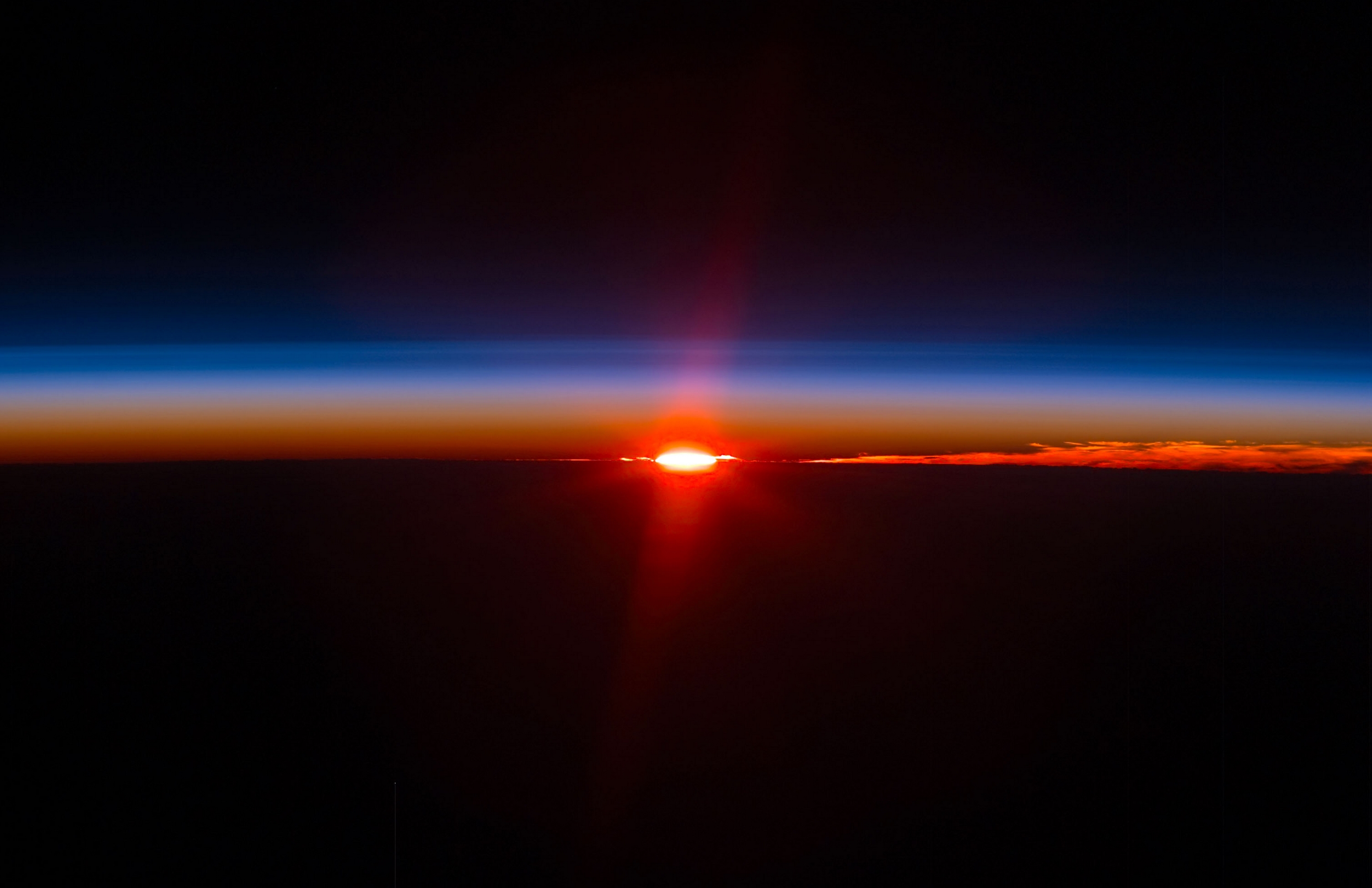
Three Scenarios for the Future of Climate Change. Elizabeth Kolbert writes for The New Yorker: “…In a third scenario, global warming could by 2050 produce global conflict that draws in poor nations and rich ones alike. This, too, already seems, to a certain extent, to be taking place. A significant body of research suggests that the Syrian civil war was caused, at least in part, by a drought that pushed more than a million people out of their villages. The war, which has claimed some four hundred thousand lives, has, in the course of nearly a decade of bloodshed, involved the U.S., Russia, Saudi Arabia, Iran, and Turkey. Future droughts in the Middle East are apt to be even more severe and prolonged, as are droughts in other volatile regions, like the Horn of Africa. It doesn’t seem that it would take too many more Syrian-scale conflicts to destabilize large swaths of the globe...”
Photo credit: Scott Kelly, NASA ISS.
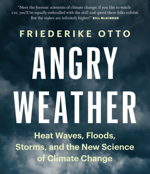
Supercomputers, Simulations and the New Science of Extreme Weather Attribution. How much is natural, how much of the extremes are flavored by a warmer, more volatile climate? A story at Yahoo Finance caught my eye: “...In the past, climate scientists have been hesitant to say any particular weather event, no matter how wild, was due to the effects of global warming, greenhouse gases, and other human causes. But Dr. Friederike Otto and the World Weather Attribution team studied Harvey and determined that climate change made the rainfall more intense, causing between 12% and 22% more water to drop on Houston and its surrounding area. It’s a relatively new science, determining “whether and to what extent anthropogenic — so human-induced — climate change alters the likelihood and intensity of extreme weather events,” Otto told Digital Trends. In her new book, Angry Weather: Heat Waves, Floods, Storms, and the New Science of Climate Change, she explains how the World Weather Attribution project began and how its attribution reports can be used to help people sue greenhouse gas emitters…”
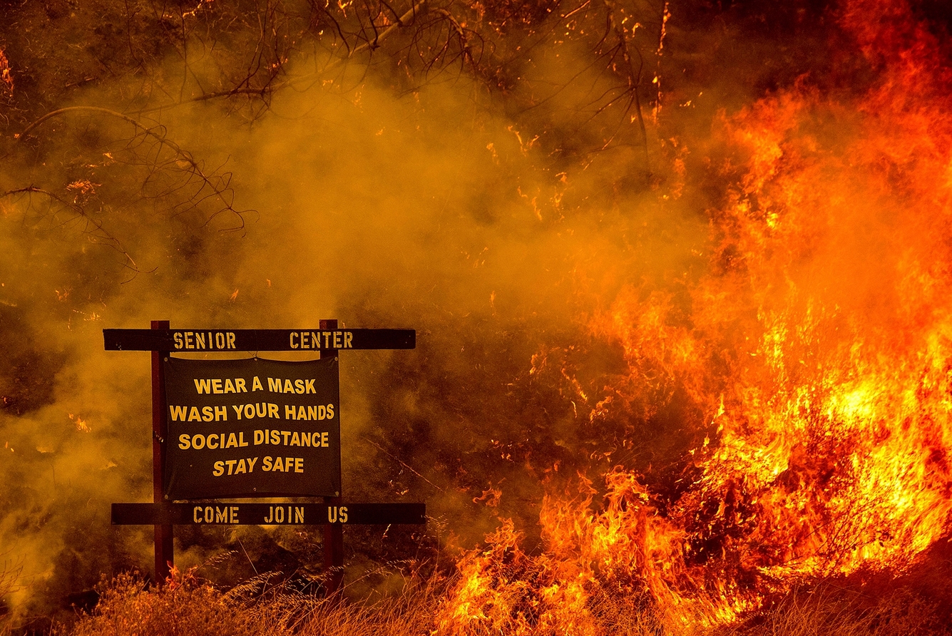
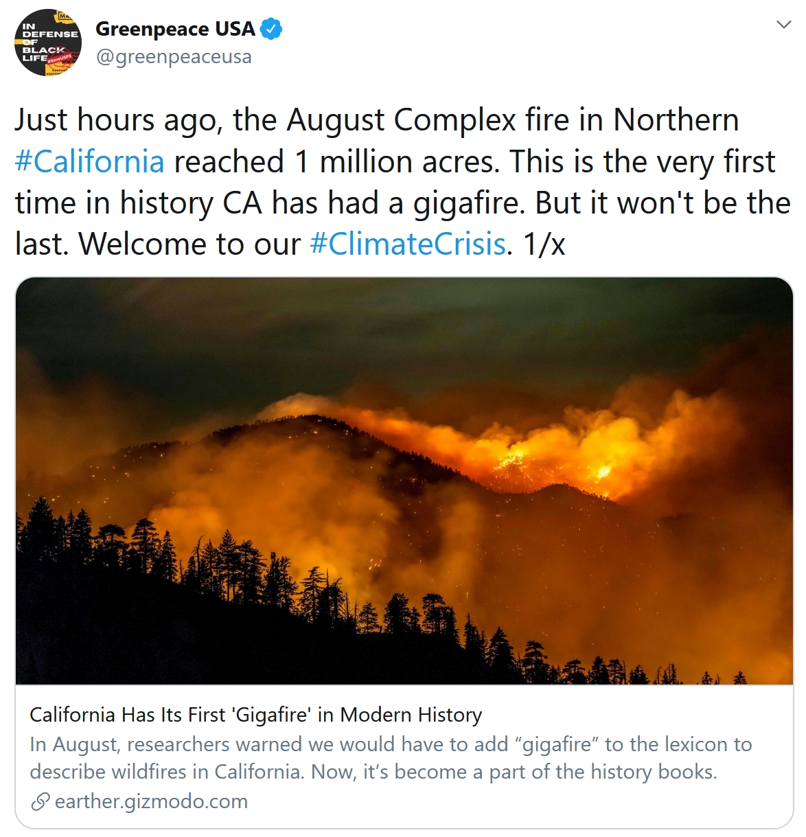
2020: The Year of the Converging Crises. Is it our collective imaginations or has something truly changed? Here’s an excerpt from Rolling Stone: “…I’ll never unsee the images I’ve seen coming out of the West the past few months: hellish skies over major cities like San Francisco and Portland, people stranded in rings of fire and rescued by airlift. I can’t imagine what it must do to your psyche to not just see the images, but to breathe the air, to lose your voice to the smoke and the ash. To know the fires are far too close and not know if there’s anywhere to run to. At the same time that California burns, the Gulf Coast drowns — battered with so much rain and wind that it barely registers as news. Hurricane Laura devastated Louisiana and Texas in early September as a massive Category 4 storm nearly 15 years to the date after Katrina scarred our collective psyche. About two weeks later, Hurricane Sally sauntered onto shore, which means we skipped from the middle of the alphabet to near the end in just two weeks…”
File photo credit: Noah Berger, AP.
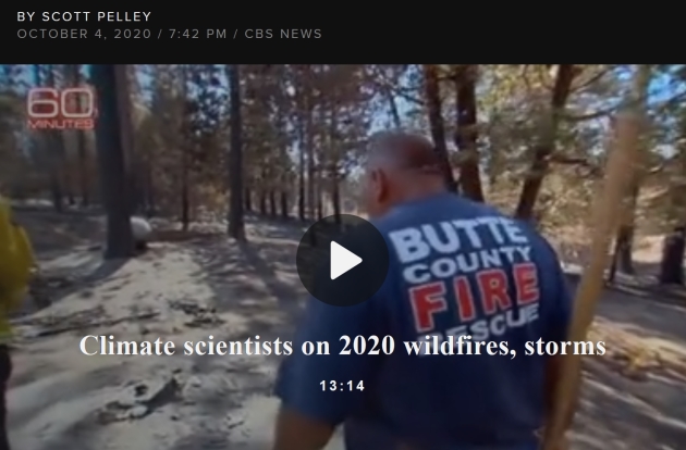
The Climate Science Behind This Year’s Wildfires and Powerful Storms. If you missed it, the 60 Minutes episode from last Sunday examined the impact of warming on this year’s weather extremes: “At least 31 have died in the largest wildfires in California history. The east is defending itself against twice the usual number of tropical cyclones. And what may be the highest temperature ever recorded on Earth came in August in the United States. It’s a torrid 2020 and it was forecast 32 years ago. In the 1980’s, a NASA scientist named James Hansen discovered that climate change, driven by carbon emissions, was upon us. His graphs, of three decades ago, accurately traced the global rise in temperature to the year 2020. Last week, we had a lot of questions for Hansen. Are these disasters climate change? Do things get worse? Is it too late to do anything? But before we get to the causes, let us show you the effects…”
Trump Team Delaying Work on Major Climate Report. E&E News has the story: “The Trump administration is slow-walking a mandatory climate report by not seeking out scientists to work on it, says one of the authors of the last National Climate Assessment. Donald Wuebbles, a climate scientist at the University of Illinois who co-led the first volume of the fourth National Climate Assessment, said the Trump administration is late in putting out a call in the Federal Register for researchers to produce the fifth version. “It’s not being approved to go out, so therefore they’re just sitting on it. And I don’t know if it’s NOAA or the White House, but somebody’s sitting on it, so that’s just holding up getting up the NCA 5 going,” Wuebbles said. By law, Congress and the White House are supposed to receive a report no less than every four years on the state of climate change and its impacts on humanity and the natural world...”
File image: Will Brown, Union of Concerned Scientists.
Exxon’s Plan for Surging Carbon Emissions Revealed in Leaked Document. Bloomberg Green reports: “Exxon Mobil Corp. has been planning to increase annual carbon-dioxide emissions by as much as the output of the entire nation of Greece, an analysis of internal documents reviewed by Bloomberg shows, setting one of the largest corporate emitters against international efforts to slow the pace of warming. The drive to expand both fossil-fuel production and planet-warming pollution comes at a time when some of Exxon’s rivals, such as BP Plc and Royal Dutch Shell Plc, are moving to curb oil and zero-out emissions. Exxon’s own assessment of its $210 billion investment strategy shows yearly emissions rising 17% by 2025, according to the internal documents…”
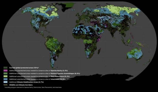
Which Places Should We Protect First to Stop Climate Change. This Interactive Map Tells You. The only way to reduce warming is to reduce emissions, slow deforestation, create new ways for agriculture to sequester carbon, etc. That said, here’s an excerpt of an interesting post at Mental Floss: “Right now, a little over 15 percent of the world’s land comprises national parks and other protected areas that people aren’t allowed to develop. In order to save the planet from the progressively devastating effects of climate change and habitat loss, that number will have to be a lot higher—around 50 percent, according to a new analysis published in Science Advances. Researchers from RESOLVE, the University of Minnesota, Arizona State University, and Globaïa spent the past two years pinpointing a “Global Safety Net” of the most important regions we must preserve not only to slow climate change, but also to safeguard Earth’s plant and animal species…”
Map credit: “A look at the Global Safety Net’s online map application.” RESOLVE.