
Recent Cold March Weather
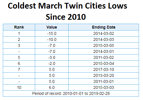
Yes, we are heading into a spell of cold weather once again here across the state, but seeing cold weather in March isn’t totally unusual. On average (over the entire Twin Cities record) we average two nights in the month of March with a subzero low… meanwhile, the latest 30-year climate normals (1981-2010) has only an average of one night at or below zero in March. Either way, it just shows that we can see this type of cold weather here during March, especially toward the beginning of the month when you look at the data. Above are the coldest lows since 2010 during the month of March, showing that the Twin Cities has dropped below zero six times in the past eight years – all of which occurred in the first five days of the month. Since 2010, the coldest we’ve dropped for a low in the Twin Cities during the month of March was -15F on March 2, 2014.
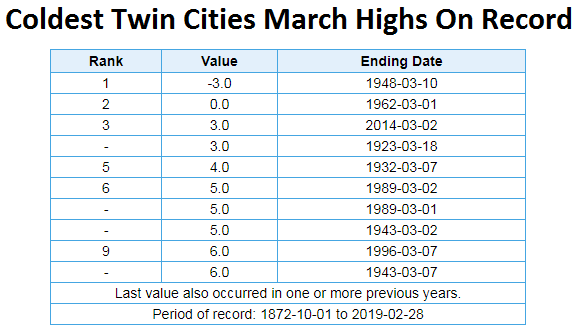
Meanwhile, only one time in March history has the temperature not climbed to at least zero – that was back on March 10, 1948, when the high only made it to -3F.
_______________________________________________
Wind Chill Advisory In Place
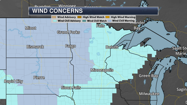
As arctic air moves into Minnesota, dangerously cold wind chills will make a return Saturday Night and Sunday morning. Due to the potential of these bitterly cold wind chills, Wind Chill Warnings and Advisories have been issued. The Wind Chill Warnings across western Minnesota are for the potential of wind chills as low as -35 to -40, meanwhile Wind Chill Advisories are in place for wind chills of at least -25. Here is the text of the Wind Chill Advisory for the Twin Cities:
...WIND CHILL ADVISORY REMAINS IN EFFECT FROM MIDNIGHT TONIGHT TO
NOON CST SUNDAY...

* WHAT...Very cold wind chills expected. Wind chills as low as
  25 to 35 below zero expected.

* WHERE...Portions of northwest and west central Wisconsin and
  central, east central, south central and southeast Minnesota.

* WHEN...From midnight tonight to noon CST Sunday.

* ADDITIONAL DETAILS...The dangerously cold wind chills could
  cause frostbite on exposed skin in as little as 10 minutes.
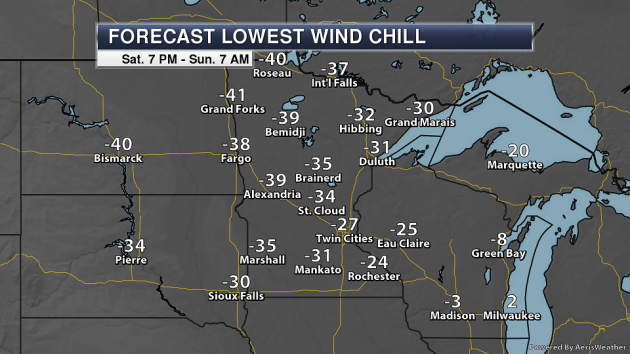
Here’s a look at the coldest wind chill values expected for select cities overnight Saturday Night into Sunday morning across the state. Many areas will have wind chill values down in the -20s and -30s, and some location in northwest Minnesota could see wind chill values in the -40s.
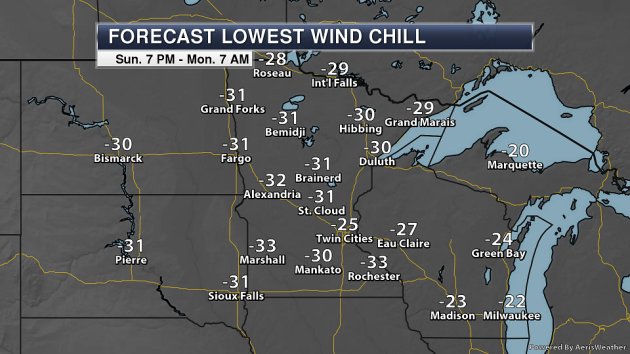
Cold windchills are also expected Monday morning, once again reaching the -20s and -30s across the state.
_______________________________________________
Snow Totals From Friday

Another round of snow impacted the region on Friday, causing travel issues once again and continuing to add to our already massive snowpiles. Officially 5.6″ of snow fell at MSP airport, but you can see some 6″+ totals did accumulate in the northwest suburbs. The highs totals from this snowstorm were:
- 6.5” – 2 miles east of Maple Grove
- 6.3” – 3 miles south of Maple Grove
- 6.0” – 3 miles north of Becker, 2 miles west-southwest of Plymouth, and Maple Grove
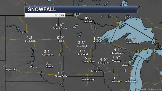
At NWS climate sites across the state, almost 4″ of snow fell in St. Cloud, with 3.1″ in Rochester, 2.3″ in Brainerd, and 1.7″ in Duluth.
_______________________________________________
Sunday National Weather Forecast
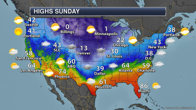
A system moving east from the Southern Plains Sunday morning to the Mid-Atlantic by the evening will bring the potential of snow from the Front Range to the Northeast and rain – heavy at times – across the Deep South and Southeast on Sunday. Meanwhile, snow will linger across the central Rockies and Intermountain West. It’ll be a cold one in the central third of the country, with highs only in the 30s for Dallas. Highs from Montana to the upper Midwest and south toward Dallas will be a good 25-45 degrees below average.
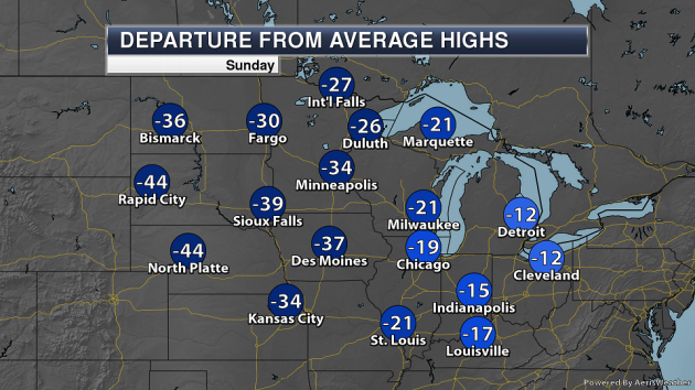
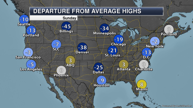
Here’s a look at the departure from average for highs across the upper Midwest Sunday, where places like Rapid City and North Platte will be almost 45 degrees below average.
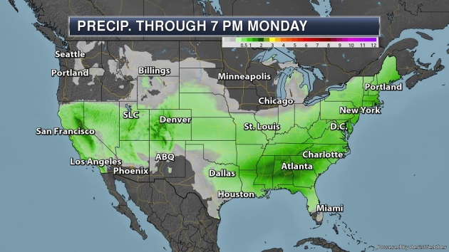
The heaviest rain through early in the week will be across the Southeast, where rainfall totals of at least 1-2″ will be possible.
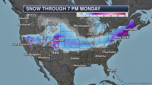
Some of the heaviest snow will be in the western mountains where at least one to two feet could accumulate in the Rockies and Sierra. Meanwhile, two systems (one on Saturday, another late Sunday into Monday) could bring a combined total of at least a foot of snow to parts of the Northeast.
_______________________________________________
Winter Storm Concerns Through Monday From The Central Plains To The Northeast – Praedictix Corporate Weather Briefing: Saturday morning, March 2nd, 2019
- As a system continues to move east this weekend, snow is expected to fall from the Front Range across the central Plains into the Northeast.
- Across the central Plains, the heaviest snow will fall across parts of Kansas into central Missouri, where snowfall totals of up to a half a foot are possible. Some icing could also occur from Texas to Missouri. Numerous Winter Storm Warnings and Winter Weather Advisories are in place.
- As this system moves into the Northeast Sunday into Monday, a band of at least 6” of snow is expected to fall from West Virginia into Maine, potentially including Boston. Winter Storm Watches are in place.

Tracking Snow This Weekend. Already this morning snow is falling across parts of western Nebraska into the Cheyenne and Denver areas. As a system continues to move east this weekend, snow will spread across the Front Range and central Plains today and tonight, working its way toward the Northeast by the end of the weekend. This snow will produce a band of up to 6” across parts of Kansas into Missouri, with potentially higher totals possible in the Northeast.

Winter Weather Concerns. Due to the expected snow and ice across the Front Range and Central Plains, numerous Winter Storm Warnings and Winter Weather Advisories have been issued, including for the following cities:
- Cheyenne, WY: Winter Storm Warning until 11 PM tonight for 4-8” of snow.
- Denver, CO: Winter Weather Advisory from 9 AM today to 11 AM Sunday for 4-8” of snow.
- North Platte, NE: Winter Weather Advisory until 6 AM Sunday for 3-5” of snow.
- Dodge City, KS: Winter Storm Warning from 6 PM tonight to Noon Sunday for 3-6” of snow.
- Wichita, KS: Winter Weather Advisory from 8 PM tonight to Noon Sunday for 2-5” of snow.
- Oklahoma City, OK: Winter Weather Advisory from 6 PM tonight to Noon Sunday for up to 3” of snow and a glaze of ice.
- Kansas City, MO: Winter Weather Advisory from 9 PM tonight to Noon Sunday for 3-5” of snow.
- St. Louis, MO: Winter Weather Advisory from Midnight tonight to 3 PM Sunday for 3-5” of snow.

Forecast Snow Totals. The heaviest snow with this system across the central United States is expected to fall from Kansas into central Missouri, where totals up to about 6” are possible. Snow totals have been decreased for the St. Louis metro, which is now only expected to see about 3-4” of snow. This snow is still expected to make travel difficult due to slick roads, and stronger winds could result in blowing and drifting snow.

Forecast Ice Totals. South of the heaviest snow, from the panhandle of Texas across Oklahoma and into southwest Missouri, accumulating ice will be a concern. Even though ice amounts are generally expected to be under a tenth of an inch, this could cause slick conditions on the roads.

Northeast Winter Storm Watches. As this system continues east toward the end of the week, heavy snow will start to spread into the Northeast Sunday, lingering into Monday. Due to the potential of heavy snow (6”+), Winter Storm Watches have been issued from West Virginia into Maine, including:
- Scranton, PA: From Sunday afternoon to Monday morning for 6-9” of snow.
- Boston, MA: From Sunday evening to Monday morning for 5-7” of snow.
- Portland and Augusta, ME: From Sunday evening to Monday afternoon for 6-10” of snow.


Expected Northeast Snow. Through the Monday timeframe, the Northeast will be impacted by two separate systems. The first one, with expected snow totals shown in the first graphic above, could bring about 3-5” of snow to Boston today, with the heaviest expected south of town. The second graphic shows combined snow totals from both systems. With the second system moving through Sunday into Monday, a swath of 6-12” of snow is expected with it, especially from eastern Pennsylvania to Downeast Maine. This could include the Boston area – however, snow totals there will be dependent on when snow changes over to rain or a mixture of rain and snow, and is something we’ll keep an eye on over the next couple days.
D.J. Kayser, Meteorologist, Praedictix
_______________________________________________
Snowpack more than doubles in a month — and it’s still storming in the Sierra
More from the Los Angeles Times: “They may have been cold and wet, but that was a good thing for surveyors making their monthly winter trip to the state’s Phillips station to measure the snowpack Thursday morning. The weather was stormy enough that the California Department of Water Resources couldn’t livestream the ritual, as it typically does for those eager to know the progress of the state’s water supply. But when the results were in, they were great: The snowpack had more than doubled from last month — to 113 inches deep, or 43½ inches of water if it were to melt, said spokesman Chris Orrock. The snowpack is the fifth-deepest recorded at Phillips station since the department started surveying the snow there in 1941, Orrock said. “We’re very happy about it,” he said. “It was cold. It was snowing the whole time … and sticking.””
A Future of Heavier Rainstorms Could Be a Death Sentence For Corals
More from Earther: “Corals have it rough. From warming oceans to sunscreen, threats are everywhere. Now, add freshwater to the list. A study out last week in the journal BMC Genomics documents how low levels of salinity can stress out corals. The research highlights yet another environmental problem that may become more frequent in a warming world, due to an increase in the intensity of severe rainfall events. Climate change may increase the severity of tropical cyclones, including upping their rainfall. By making corals’ watery environments less salty, this can result in “freshwater bleaching,” a biochemical response similar to what happens when corals bleach due to excessive heat, according to a press release. But unlike heat-related bleaching—which corals often recover from after temperatures return to normal—the response these researchers are concerned with may result in mortality after a few days.”
Jay Inslee, Washington Governor and Climate Advocate, Enters 2020 Race
More from The New York Times: “Jay Inslee, the governor of Washington and former member of Congress who has made climate change and the environment his signature issues, jumped into the crowded field of 2020 Democratic contenders for president on Friday. Mr. Inslee, 68, has led the state during a powerful economic expansion since taking office as governor in 2013, especially in the Seattle area. Amazon and other tech companies have hired tens of thousands of workers, and export-driven manufacturers like Boeing have boomed. But he has had mixed success in getting some of his ideas put into practice, especially those on renewable, low-carbon energy. He failed twice with voters, and once in the Legislature, to enact the nation’s first carbon tax, aimed at reducing planet-warming greenhouse gas emissions. Many residents, elected officials and business leaders balked, concerned that energy costs would rise.”
_______________________________________________
Thanks for checking in and have a great Sunday! Don’t forget to follow me on Twitter (@dkayserwx) and like me on Facebook (Meteorologist D.J. Kayser)!
– D.J. Kayser
