
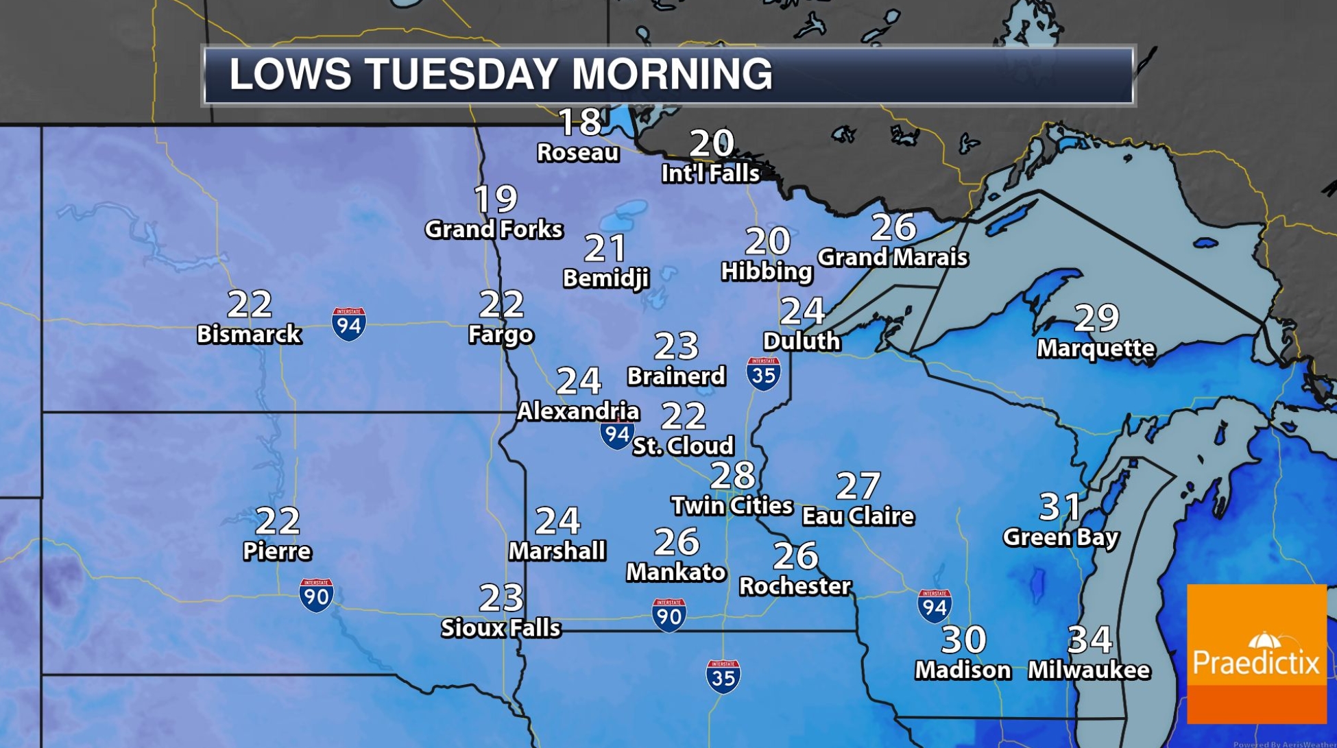
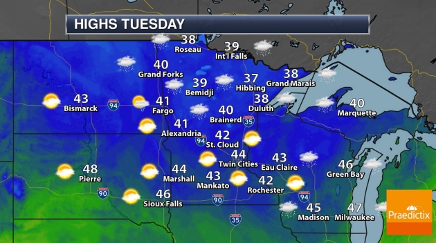
Frost, Freeze and Flakes? Here We Go
“Cold! If the thermometer had been an inch longer we’d have frozen to death” wrote Mark Twain. I’m not suprised or offended temperatures are tumbling. Considering the sun is as high in the sky today as it was back on February 24 we shouldn’t be the least bit surprised Canadian air is rushing south of the border.
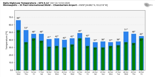
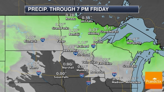
It’s not an exaggeration to say the next week or so will look and feel more like early November. Wind chill is back, and a light mix of rain and snow can’t be ruled out early Saturday, even in the MSP metro. Beware of shiny objects, like snowfall accumulation predictions 3-7 days into the future. That’s more of a horoscope than a weather forecast.
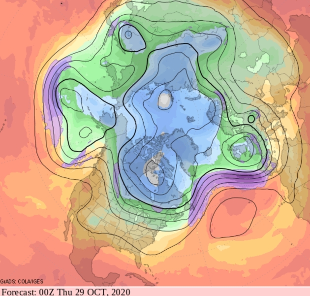
ECMWF (the European model) is hinting at a major, prolonged rain event next week. Confidence levels are low, but with any luck we’ll see more significant rain to recharge depleted soil moisture before a widespread freeze sets in.
As I’ve been telling my dear wife for 36 years, it may be time to lower your expectations. A warm front now? 50s, maybe 60.
GFS outlook above: NOAA and WeatherBell.
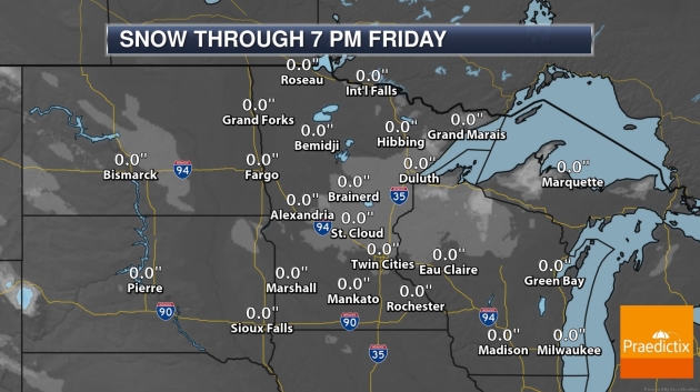
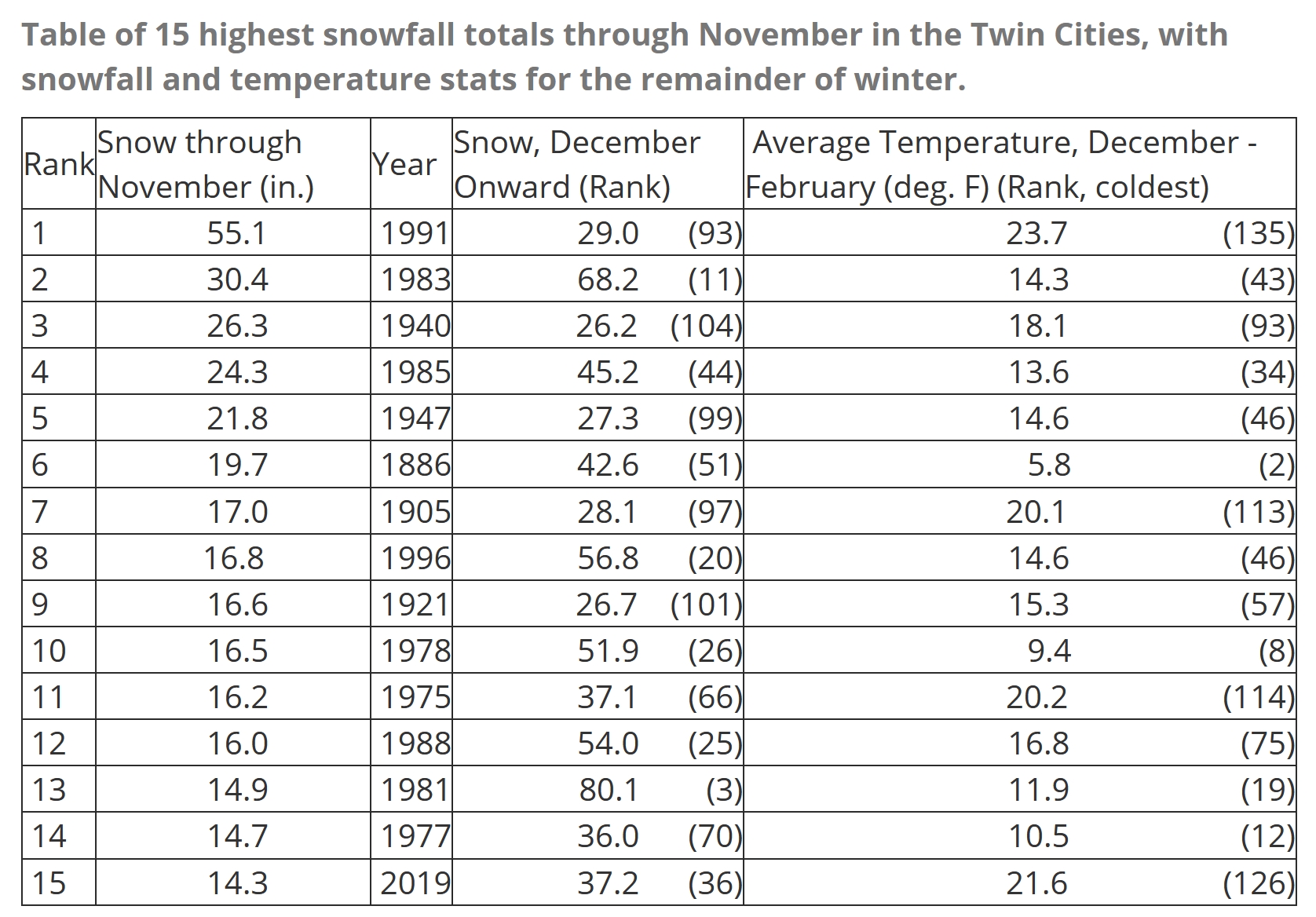
Does Snow in October Mean We’re In For a Rough Winter? The short answer is no. And The Minnesota DNR has the data to back that up: “…So, do early snows tell us anything about the coming winter? In short, no. It appears that an October snow is just an October snow, and has no bearing on the remainder of winter. From 1884 through 2019, 45 out of 136 Octobers in the Twin Cities have seen at least one day with measurable snow. The winters that followed those instances of snowfall have spanned nearly the entire spectrum of possibilities: dry, wet, snowy, cold, warm, and of course, average. In northern Minnesota, where October snows occur most years, the range of winter conditions after those snows is even wider. Even a persistently snowy autumn cannot promise us a brutal remainder of winter…”
Graphic credit: Minnesota DNR.
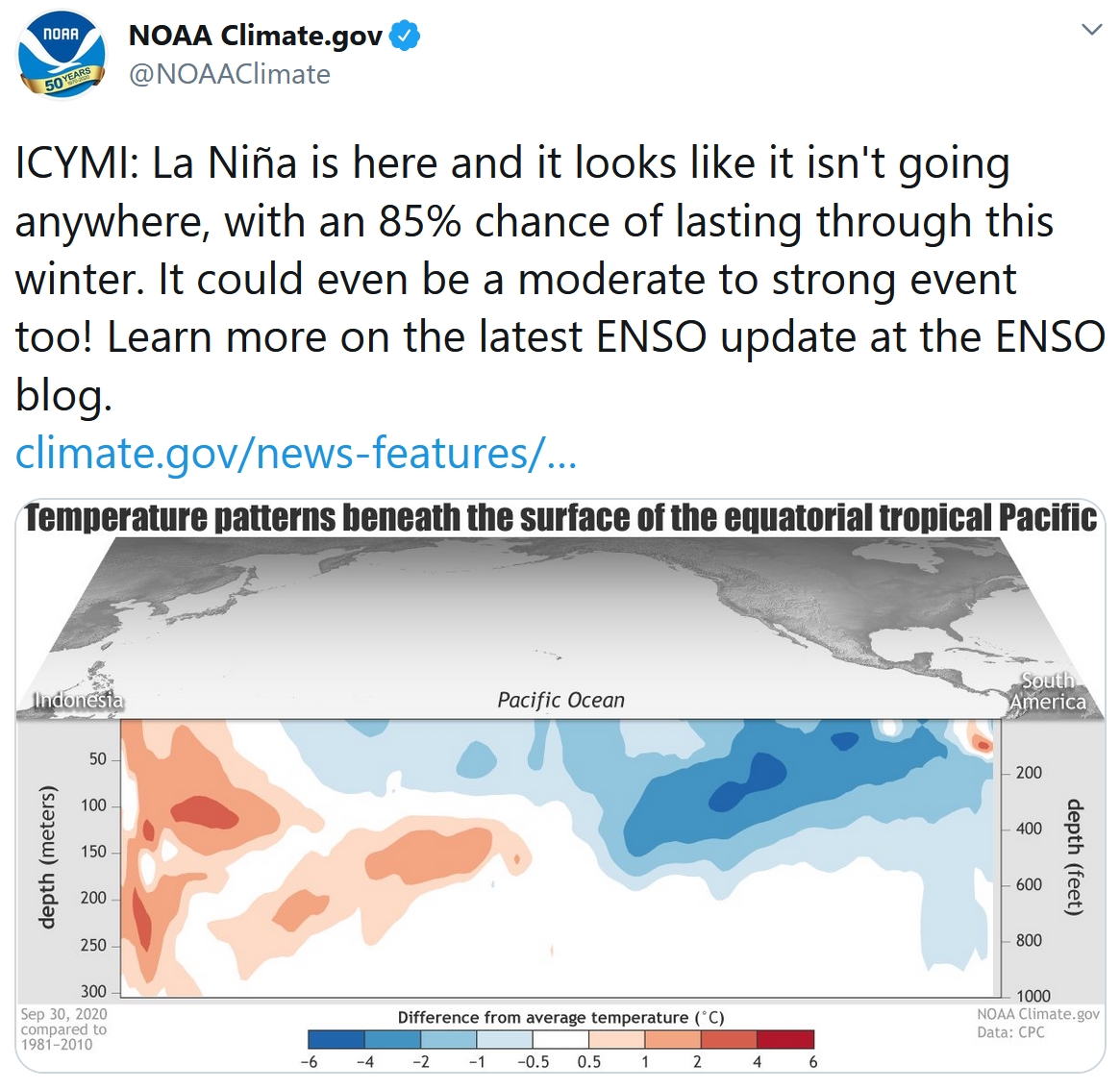
85% Chance La Nina Lingers Through Winter. NOAA’s Climate.gov has an update; here’s an excerpt: “…The altered atmospheric circulation of ENSO affects global weather (here’s how that works in general and La Niña in specific). Since ENSO can be predicted months ahead of time, a lot of research has gone into understanding the patterns of ENSO’s global weather impacts. The idea is that if we can predict ENSO, we can get an early picture of what global weather could look like months into the future. A recent study by some of our colleagues at the International Research Institute for Climate and Society (IRI), led by Nathan Lenssen, carefully re-assessed global precipitation (rain, snow, etc.) patterns during ENSO events. They looked at La Niña and El Niño impacts separately, because the impacts are not always opposite. Meaning, although El Niño may be related to a wet winter in one location, La Niña doesn’t necessarily mean a dry winter in that location…”
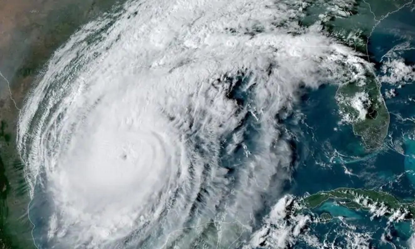
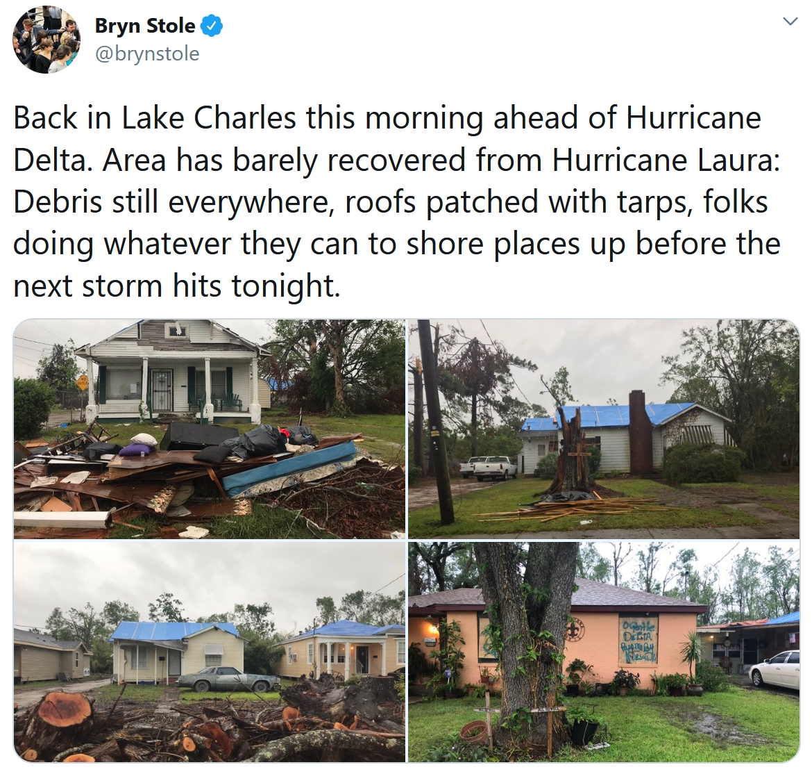
Hurricane Delta By the Numbers: Peak Winds, Rain and Surge in Record-Setting Season. Capital Weather Gang has the details on the second hurricane to strike Louisiana in a 43-day period: “Just when the record-setting 2020 Atlantic hurricane season seemed like it couldn’t get any worse, Hurricane Delta exploded in the northwest Caribbean one week ago, plotting a devastating course from the Yucatán Peninsula to the northern Gulf Coast. It crashed into Cancún and Cozumel on Wednesday before regrouping over the Gulf of Mexico and slamming into storm-weary Louisiana on Friday night. This was the second hurricane strike in six weeks in southwest Louisiana. Residents from Lake Charles to Lafayette now find themselves cleaning up from yet another vicious storm, a process that will take months or longer to complete…”
Hurricane Delta file image: NASA.
What It’s Like to Watch Hurricanes Batter Your Hometown – Over and Over. Perspective on the unimaginable from The New York Times (paywall); here’s an excerpt: “…Repairs are set to begin soon, but there’s an eerie sense of limbo, with still another month left in what has become a record-breaking hurricane season. While the tree has been removed, and her home partly covered in blue tarp, she doesn’t yet know whether the damages caused by Hurricane Delta will delay those repairs. For now, she’s settled with my parents and me in Conroe, Texas — about 40 miles outside Houston. That sense of dislocation, and the weight of hurricanes — on my family and many others in the South — has only become more potent over the years. Natural disasters mark noticeable chapters in our lives...”

Tropical Storms Can Sometimes “Supercharge” the Hurricanes That Follow. Here’s an excerpt from a new study highlighted at National Geographic: “…But new science shows that Gordon’s effects, in conjunction with a heat wave over the region in its wake, helped Michael intensify into the strongest storm ever to make landfall in the Florida Panhandle. The scenario “supercharged the ocean battery” that powered the very intense hurricane, says Dzwonkowski. Tropical cyclones feed on hot ocean waters. Warm water acts as storehouse of energy that storms can draw on, like a battery: the hotter the water, or the more of it there is, the more energy can be transferred into the air above. Cold water, in contrast, can drain energy from a storm…”
October 9, 2018 file image of Hurricane Michael: AerisWeather.
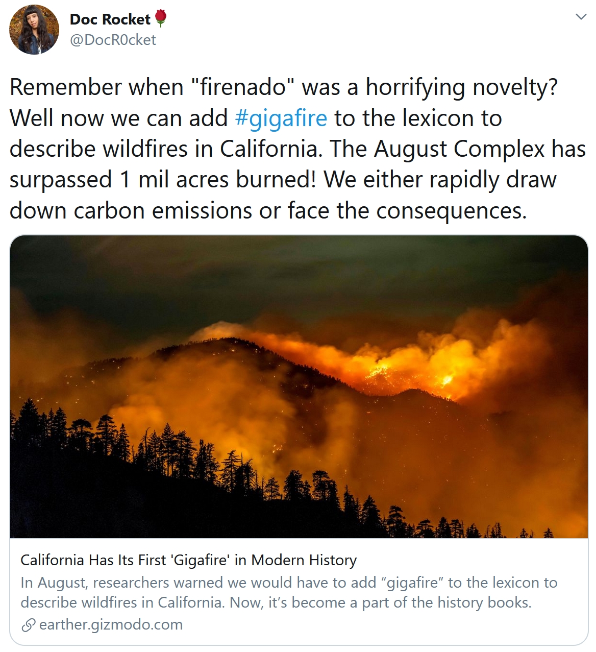
What Exactly Is a Gigafire? Here’s an excerpt from Mental Floss: “…The term gigafire is thought to have originated in the comments section of the Wildfire Today website. In 2017, a visitor to the site with the screenname “kevin9” proposed that fires consuming over 1 million acres should be dubbed gigafires. The site began using the term for wildfires that met or exceeded that threshold in Australia. The record-setting wildfire destruction this year is thought to be exacerbated by climate change, with hotter and drier conditions providing an ideal setting for fires to take hold and spread. As of Monday, firefighters had contained roughly 65 percent of the California blaze...”
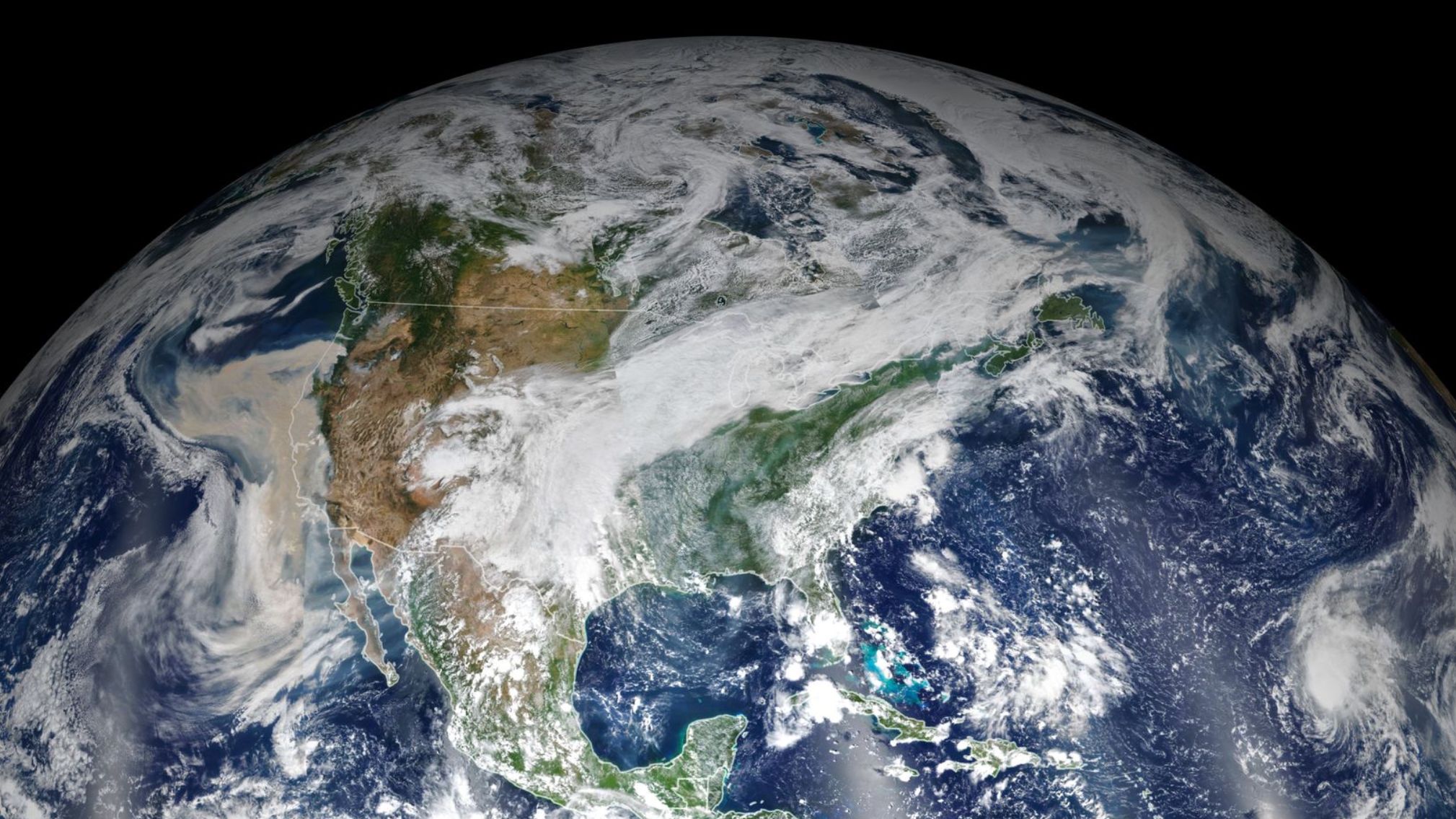
Wildfire Smoke Travels Far But Never Really Disappears. Popular Science has an interesting post with data I wasn’t aware of – here’s an excerpt: “…Just as local weather impacts smoke movement, so too can smoke change local weather patterns, says Clements. When smoke shades the incoming rays of light, the temperature differential between the shaded and unshaded portions of air can create a “density current” in which air flows from areas of high to low pressure, often in the opposite direction of the prevailing wind. These currents can carry smoke particles far from the origin of the fire. This “smoke shading” can also suppress ambient wind. A warm and sunny day spurs convection currents, Clements explains. “Eddies and thermals form, which makes the atmosphere more turbulent at the surface,” he says...”
Image credit: “A massive cloud of smoke on September 9, 2020.” NASA Earth Observatory.
Fifth of Countries at Risk of Ecosystem Collapse, Analysis Finds. The Guardian has a sobering analysis: “One-fifth of the world’s countries are at risk of their ecosystems collapsing because of the destruction of wildlife and their habitats, according to an analysis by the insurance firm Swiss Re. Natural “services” such as food, clean water and air, and flood protection have already been damaged by human activity. More than half of global GDP – $42tn (£32tn) – depends on high-functioning biodiversity, according to the report, but the risk of tipping points is growing. Countries including Australia, Israel and South Africa rank near the top of Swiss Re’s index of risk to biodiversity and ecosystem services, with India, Spain and Belgium also highlighted…”
File image: NASA.
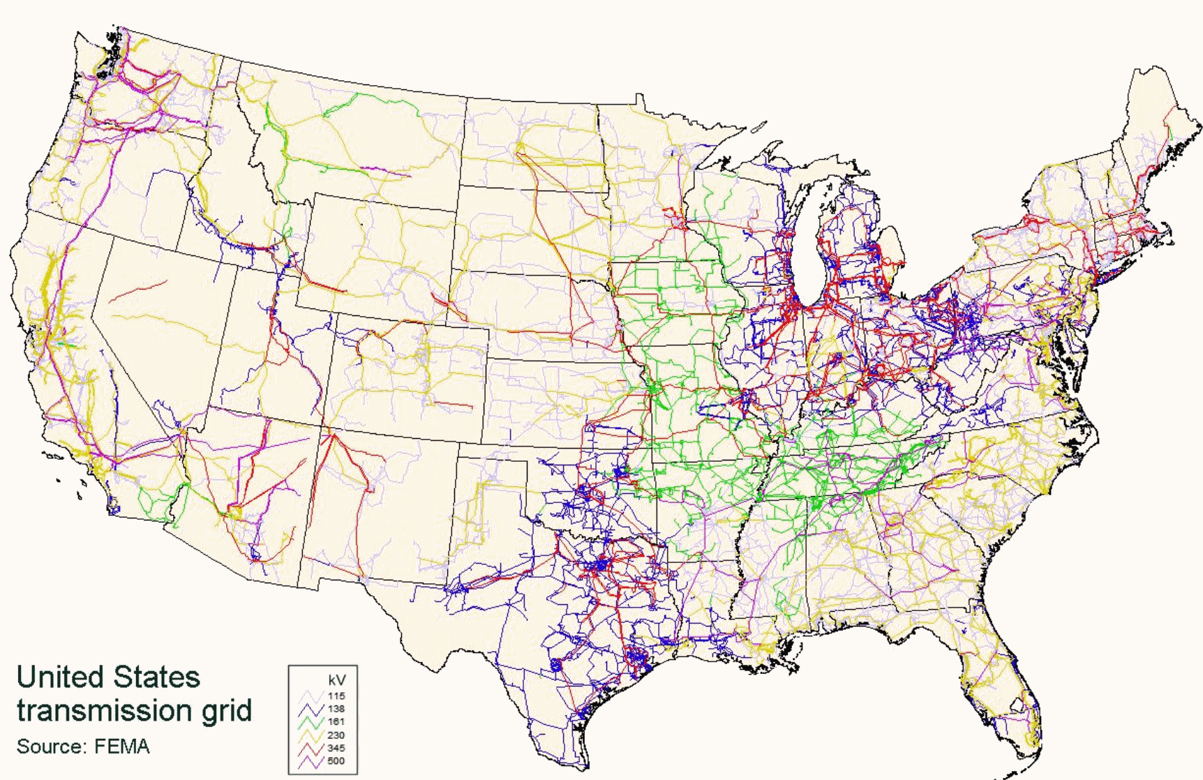
America Needs a Modern Electric Grid. There are more sustainable, ultimately cheaper ways to keep the lights on. What worked in the 1970s may not work so well in the 2030s. Niskanen Center has an update; here’s an excerpt: “…The electric system we could have, aside from being advanced, efficient, clean and reliable, will also be cost effective. In fact, it would be cheaper than the one we have. Unreliable power is expensive power. According to the Energy Information Administration, 46 percent of the outages in 2019 resulted from transmission failures. Because our outdated grid cannot withstand extreme weather events, industries and businesses need expensive back-up power, that bill is ultimately footed by consumers. Consumers are also paying for expensive wholesale power simply because we lack the necessary transmission to access more affordable power from other regions…”
Map credit: FEMA.

Flight to Nowhere Sells Out in 10 Minutes. Don’t laugh – people are so hungry to travel during a pandemic they’ll cough up good money to go…nowhere. Oddee.com has the story; here are a few snippets: “…Australian airline Qantas had a brilliantly stupid idea. As a company they naturally like money, and because their planes could fly nowhere, why not sell a flight precisely there? Despite how ridiculous it sounds, in mid-September Qantas started offering the Great Southern Land scenic flight. The flight takes off from the Sydney Domestic airport and – seven hours later – lands back in the same place. When the tickets went on sale in September, the whole plane sold out in less than ten minutes. “It’s probably the fastest selling flight in Qantas history...”
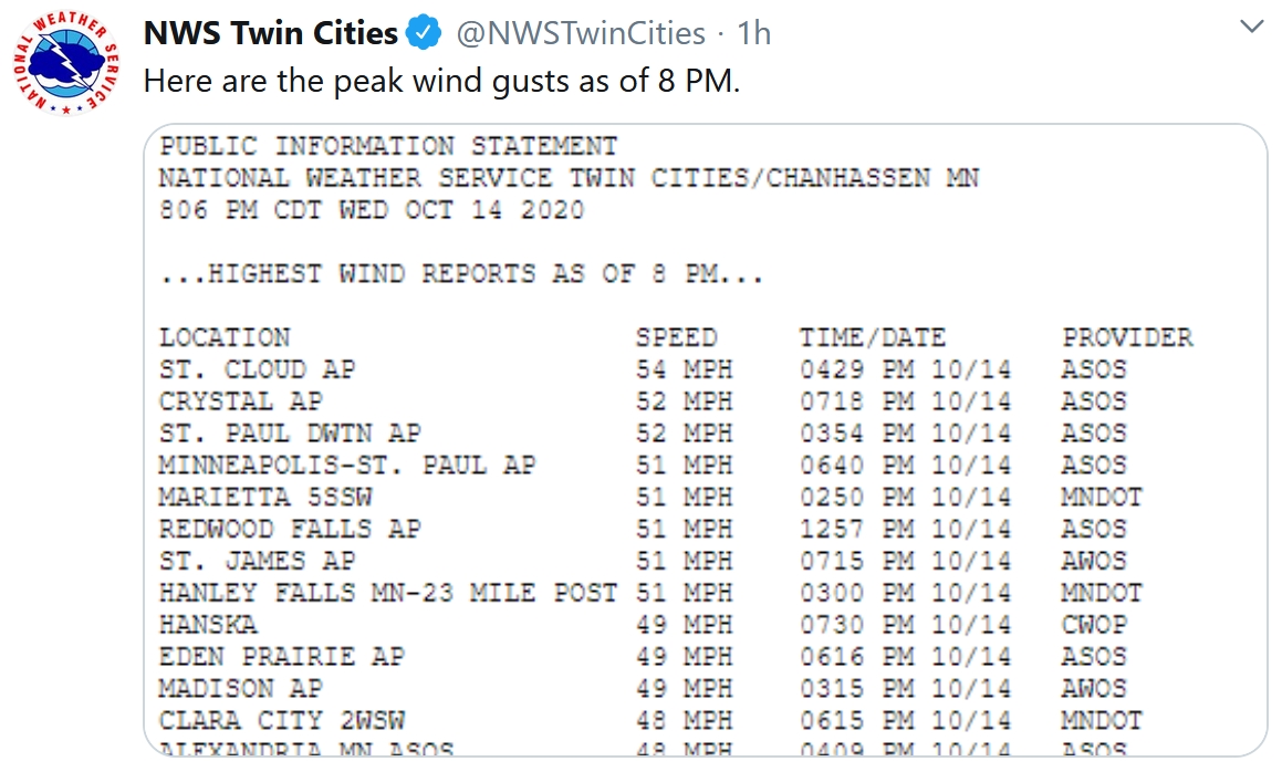
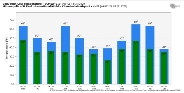
63 F. high in the Twin Cities on Wednesday.
59 F. average high at MSP on October 14.
50 F. maximum temperature on October 14, 2019.
October 15, 1968: Unseasonably warm weather moves into central and southern Minnesota. The high was 85 in the Twin Cities.
October 15, 1899: Heavy rain falls, with 3.2 inches in the St. Cloud area and 2.1 inches in Willmar.

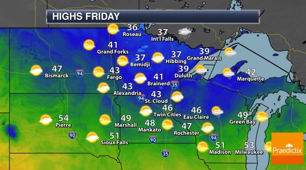
THURSDAY: Mostly cloudy, windy. Winds: NW 15-25. High: 48
FRIDAY: Lingering clouds, possible sprinkle. Winds: W 10-20. Wake-up: 34. High: 46
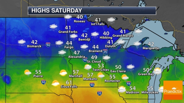
SATURDAY: Early mix? Then drying out, milder. Winds: NW 15-25. Wake-up: 37. High: 56
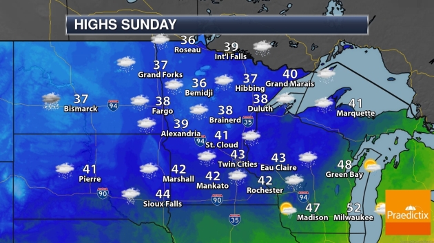
SUNDAY: Mostly cloudy, probably dry. Winds: NW 10-15. Wake-up: 35. High: 48
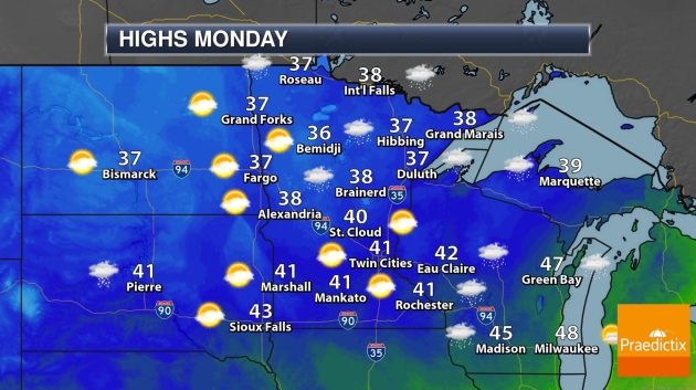
MONDAY: Light rain or mixed precip. possible. Winds: N 5-10. Wake-up: 33. High: 39
TUESDAY: A few light showers in the area. Winds: E 8-13. Wake-up: 30. High: near 40
WEDNESDAY: Steadier cold rain develops. Winds: E 10-20. Wake-up: 37. High: 48
Climate Stories…
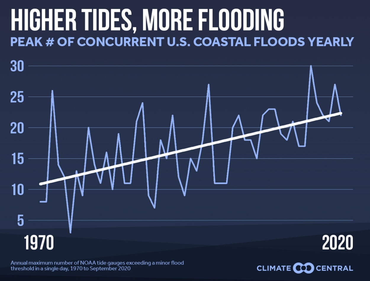
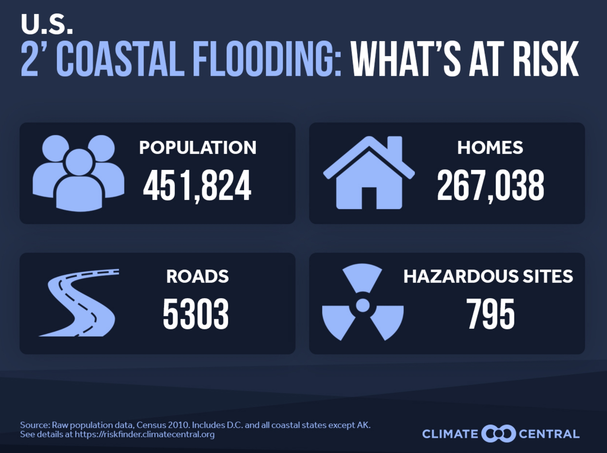
More Frequent and Pervasive Coastal Flooding. Climate Matters connects the dots on frequency and intensity of coastal flooding in the USA: “Coastal floods, caused by storms or astronomical tides—or a combination of both—are becoming more common as sea levels rise. King tides, the nickname for some of the highest astronomical tides of the year, are expected along the East and West Coasts this week, raising the risk of coastal flooding. High tide flooding has doubled in frequency since 2000, and could double again, or even triple, in the next ten years. A new analysis by Climate Central shows that concurrent flooding, or floods occurring in multiple places at the same time, is also on the rise. September 22nd set a record for the highest number of concurrent coastal floods in a September, with flood-stage water levels recorded at 84 currently active coastal tide gauges around the U.S. Even low levels of flooding can have serious consequences for coastal communities, by closing roads, degrading infrastructure, and reducing property value...”

Trump to Sign “Trillion Trees” Executive Order. Will planting more trees work? Here’s an excerpt from Axios: “President Trump will sign an executive order Tuesday designed to put more weight behind the administration’s role in the international One Trillion Trees Initiative, a White House official said. Why it matters: White House support for the initiative contrasts with Trump’s overall climate posture. He rejects consensus science on human-induced warming and is scuttling Obama-era emissions rules. Supporting trees, however, has been one narrow way Trump and other Republicans have cautiously backed action...”
Illustration credit: Aïda Amer/Axios.
Climate Migration. The nuggets above are from a post at Quartz, focused on climate migration (which I would argue is already underway).
UN-Relenting Climate Disasters: Climate Nexus has headlines and links: “Climate change has driven a dramatic increase in extreme weather events over the past 20 years, and will continue to exact enormous human and economic harms in the future, the United Nations found. Climate change, caused by burning fossil fuels, increases global temperatures which, among other things, supercharges heat waves, droughts, wildfires, hurricanes, and other storms. There have been 7,348 major disasters since 2000, claiming 1.23 million lives, affecting 4.2 billion people and costing $2.97 trillion in economic damages, according to the report. Disasters caused by extreme weather accounted for 6,681 of those events, nearly double the number of extreme weather disasters recorded in the previous 20 years. “We are wilfully destructive. That is the only conclusion one can come to,” Mami Mizutori, the U.N. Secretary-General’s special representative for disaster risk reduction, told reporters.” (Reuters, The Guardian, Thomson Reuters Foundation, AP, Al Jazeera, The Hill, E&E $)

“Uninhabitable Hell”. Climate Change and Disease Threatens Millions. Here’s the intro to a story at Thomson Reuters Foundation: “A jump in climate-related disasters this century, along with the global coronavirus pandemic, show political and business leaders are failing to stop the planet turning into “an uninhabitable hell” for millions, the United Nations said on Monday. The last two decades saw the number of disasters caused by extreme weather nearly double to 6,681, up from 3,656 between 1980 and 1999, according to a report issued ahead of the International Day for Disaster Risk Reduction on Oct. 13. Worsening floods and storms accounted for about four-fifths of the total from 2000-2019 but major increases were also recorded for droughts, wildfires and heatwaves…”
File image: NOAA.

“Staggering” Rise in Climate Emergencies in Last 20 Years, New Disaster Research Shows. UN News has more perspective: “…According to the UNDRR report – produced with Belgium’s Centre for Research on the Epidemiology of Disasters at UCLouvain – there were 7,348 recorded disaster events worldwide, during the last two decades. Approximately 1.23 million people died – approximately 60,000 per year – with more than four billion affected in total; many more than once. These two decades of disaster also caused $2.97 trillion in losses to the global economy, with data also indicating that poorer nations experienced deaths rates more than four times higher than richer nations. By comparison, the previous 20-year period (1980 to 1999) saw 4,212 reported disasters from natural hazards, with 1.19 million deaths, more than three billion people affected and economic losses totalling $ 1.63 trillion...”

Climate Change: Better Warning Systems Needed for Extreme Weather. BBC News reports: “A new UN report says the world needs to rapidly raise investment in early warning systems for extreme weather events. Over the past 50 years, recorded disasters have increased five-fold, thanks in part to climate change. The study warns that one in three people on Earth are not adequately covered by warning systems. The numbers of people in need after natural disasters could increase by 50% over the next decade. Over the past 50 years, it says, some 11,000 disasters involving weather, climate and water-related hazards have occurred claiming two million lives and causing more than $3.5 trillion in economic losses…
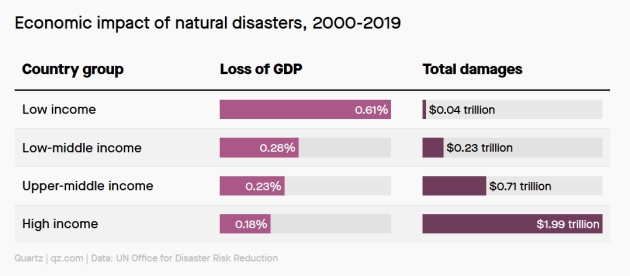
Global Climate Inequality, In One Chart. Here’s an excerpt from a Quartz post: “…But tallying the damages obscures the fact that in low-income countries, a much greater portion of GDP is at stake. In other words, even a relatively low-cost storm can send disproportionate shockwaves through the economy. That’s one conclusion from a new United Nations report on the economic and human toll of disasters over the last two decades. Although total damages rise in wealthier countries, the overall loss of GDP is highest in poorer countries. The report also concludes that frequency, cost, and fatality of storms are all on the rise, which means these disparities are only likely to increase…”
Polar Ice, Atmospheric Water Vapor Biggest Drivers of Variation Among Climate Models. Overall climate models are fairly similar in predicting future scenarios. ScienceDaily highlights new research that explains many of the discrepencies in model results: “…A Florida State University researcher is part of a team that has found varying projections on global warming trends put forth by climate change scientists can be explained by differing models’ predictions regarding ice loss and atmospheric water vapor. The work will help climate scientists reconcile various models to improve their accuracy, said Florida State University Meteorology Professor Ming Cai, one of the authors of the study published in Nature Communications . Climate scientists agree that the Earth’s surface temperature is warming, but the details of exactly where and by how much are less clear...”
File image: NASA.