

Warming Trend Likely Into Mid-October
“Do not let the behavior of others destroy your inner peace” said the Dalai Lama. I vaguely remember inner peace. Someone freeze me like a popsicle and thaw me out in 2022.
I achieved some level of inner peace gazing at the weather models this morning. A mild bias will spark an outbreak of smiles, shorts and sunglasses late next week, and maybe the week after that.
A frost can’t be ruled out in the outlying suburbs Friday and Sunday. On average the official first 32-degree low at MSP comes October 13. The first tenth of an inch of snow usually arrives November 6. And the average first skid-worthy inch of slush comes November 21.
A few more instability showers pop today, and a stray shower is possible Saturday – but this weekend looks drier than it did a few days ago.
Next week is just the appetizer with a shot at 70F Tuesday. NOAA’s GFS model predicts metro highs near 80 between October 8-12, before an (inevitable) cold front bursts our balmy-weather-bubble.
Meditate on this: good leaf-peeping weather is coming.
Photo from Deerfield Trail Lake courtesy of Pete Schenck.
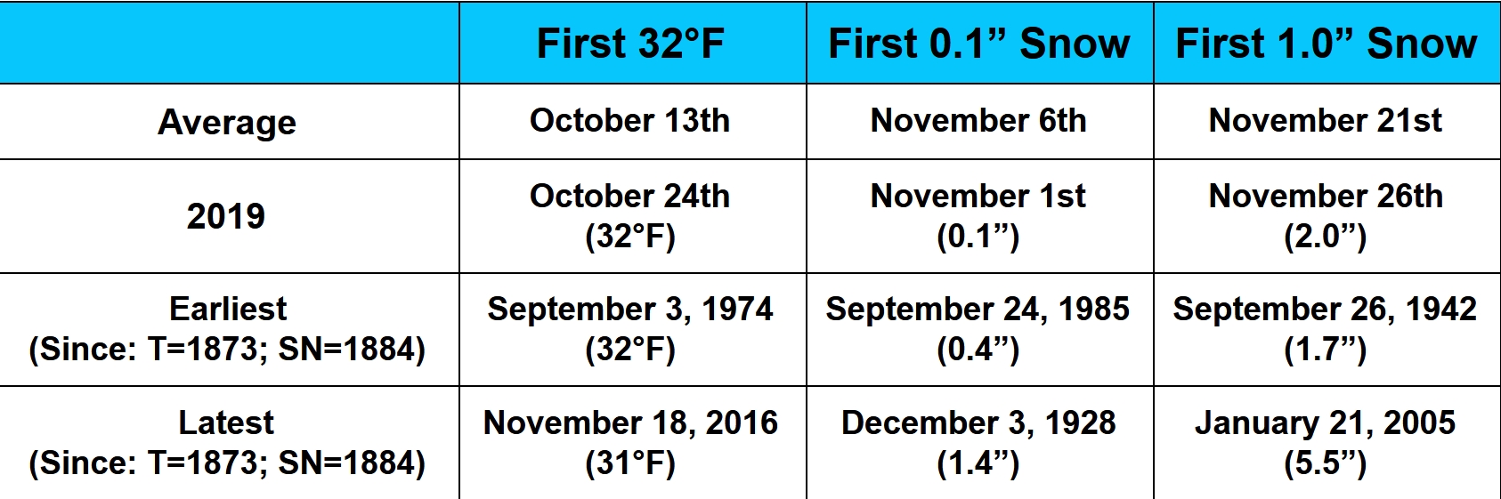
Twin Cities Data. Impress and amaze your friends with the statistics above! Good times.
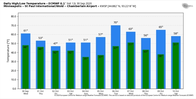
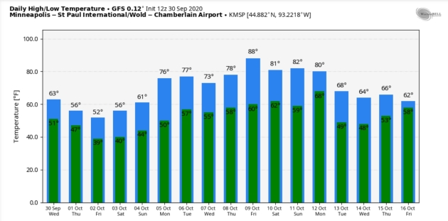
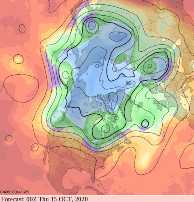
Dueling Models. Both ECMWF (top) and GFS (bottom) show a warming trend on the way, the just differ on the timing and strength. I will wash and wax Belinda Jensen’s car if it gets to 88F on Friday, October 9. Sorry GFS, it’s 2020 – so I wouldn’t rule anything out – but odds it won’t get that warm. The best chance of 70s and an outside shot at 80F will come late next week into early the following week, before temperatures cool off again. MSP Meteograms above: WeatherBell.
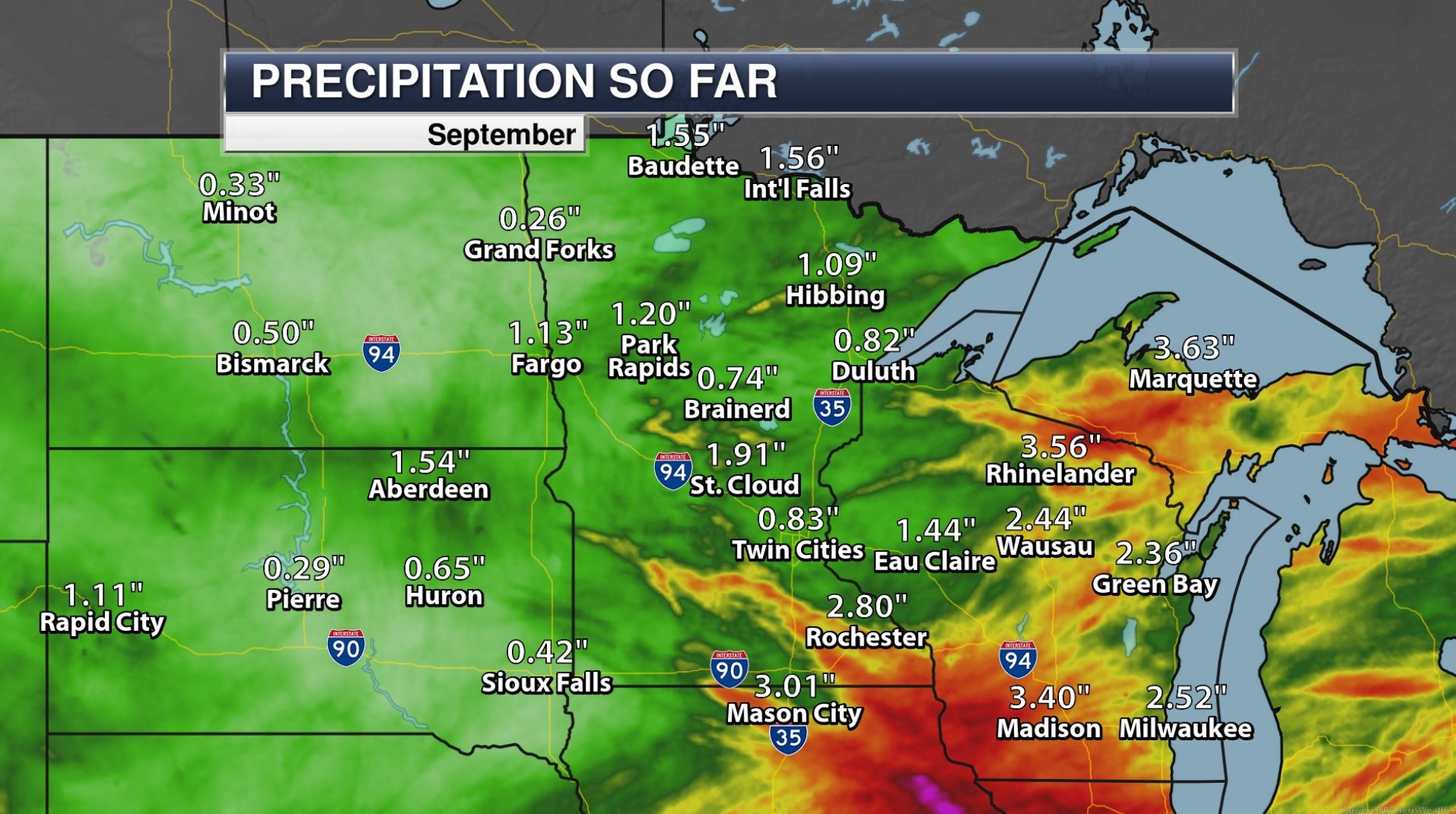
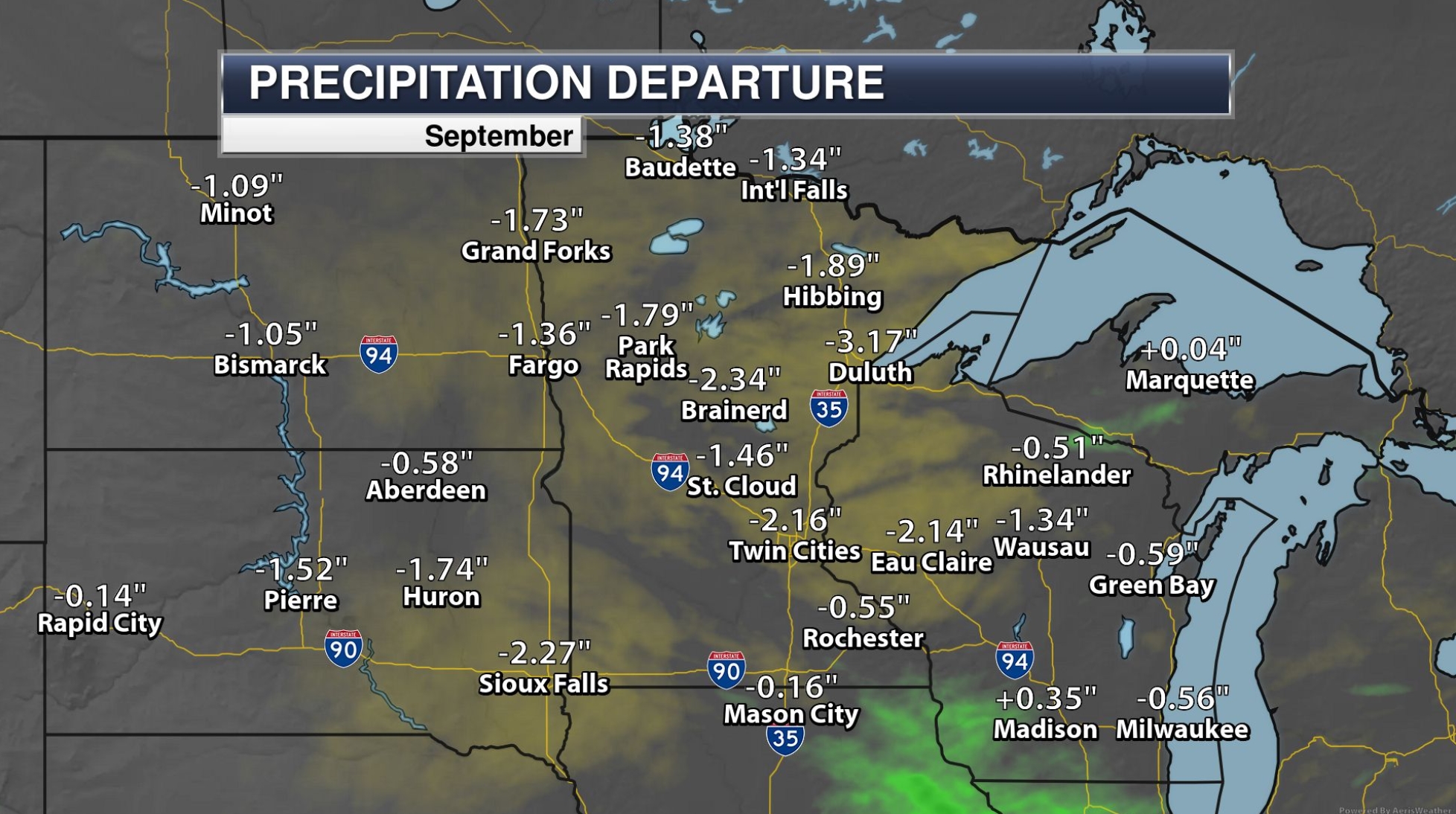
Drier Than Average September. Rainfall last month was 1-2″ less than normal across most of Minnesota and western Wisconsin. Only far southeastern counties saw above normal precipitation.

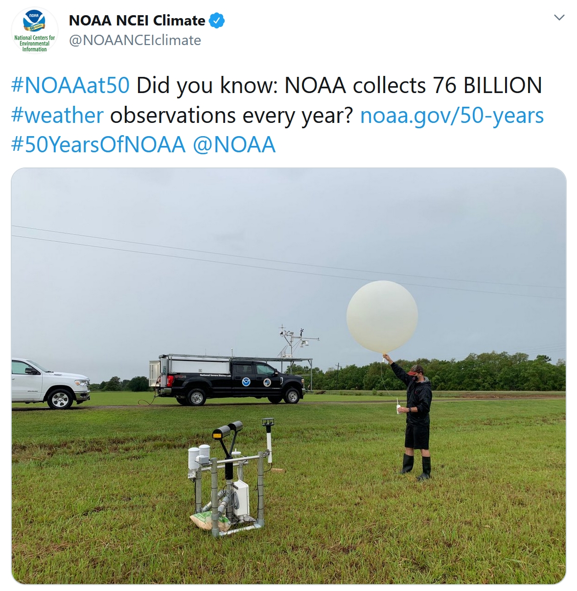
NOAA Turns 50! We can debate which weather models are more accurate, but there’s little doubt (in my mind, at least) that America has the best weather service on the planet. Kudos to the men and women of NOAA who keep us informed, in good weather and bad. Details via NOAA: “Since its inception in 1970, NOAA has evolved into one of the world’s premier science organizations with a mission that spans from the surface of the sun to the floor of the ocean. Our work is incredibly diverse, and it’s difficult to capture everything we do in one place. We hope this graphic speaks volumes about how the meaningful work we do is embedded into the fabric of American lives and livelihoods...”
A Hopeful Forecast: More Accurate Long-Term Weather Predictions. Good news (for people living in the tropics) but pesky chaos theory quickly comes into play – don’t get your hopes too high too fast. The New York Times (paywall) reports; here’s an excerpt: “...In the ’90s, we had almost no satellite observations in the southern hemisphere,” she said. “Since then, the number and quality of satellite observations has increased substantially,” so our ability to make accurate forecasts in the southern hemisphere is almost as good as in the northern hemisphere. Additionally, the global weather models that are now in development can simulate showers and thunderstorms, Dr. Judt says, whereas existing models cannot. This, coupled with a series of weather satellites set to launch over the next few years, should translate to longer lead times for tropical forecasts. “We should see an improvement in tropical weather prediction in the next 10 years,” he said…”
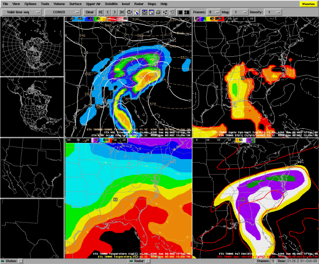
AWIPS file image courtesy of NOAA.
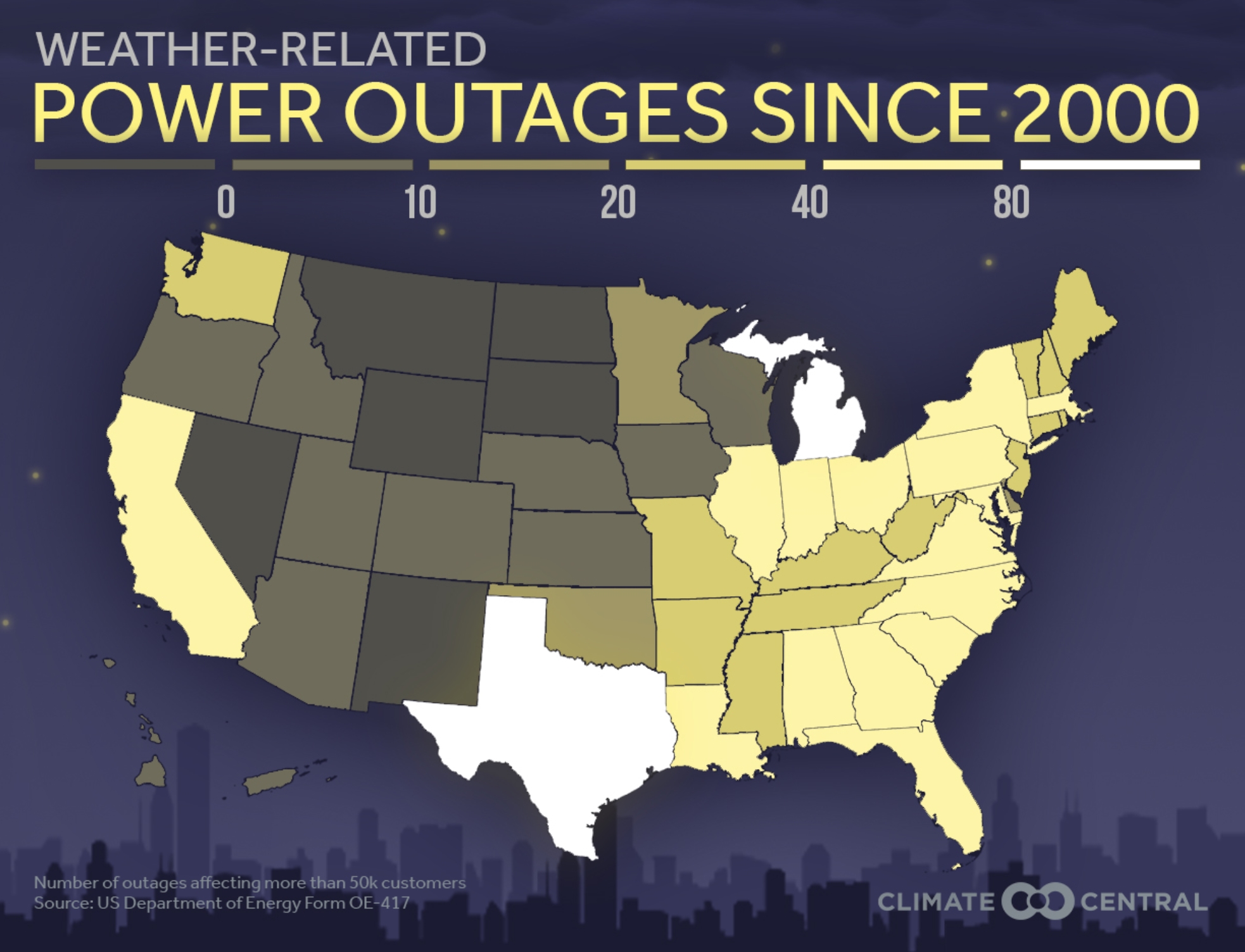
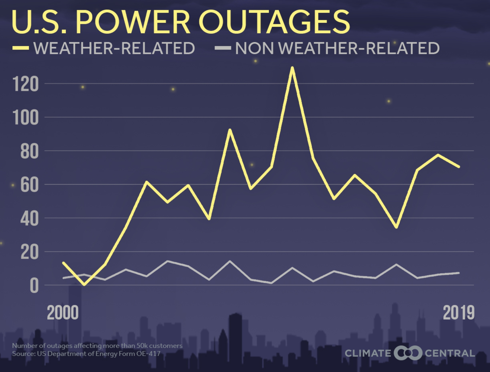
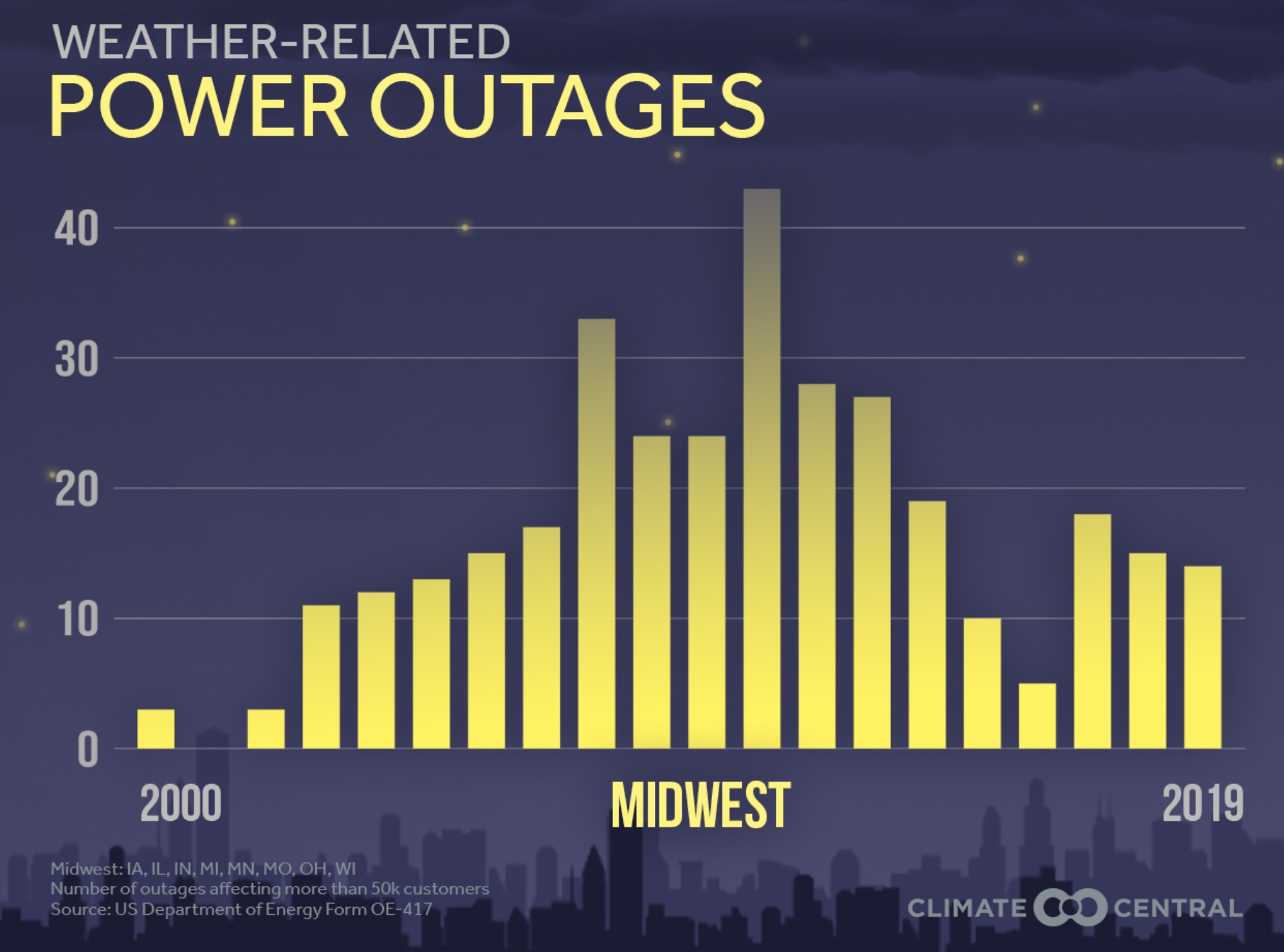
Extreme Weather and Power Outages. How much is natural variability, demographics (more people living in risky areas) and a rapidly changing climate? Climate Central has perspective: “…Hurricanes, wildfires, ice storms, flooding, heat waves and other extreme weather events are growing in number or intensity with climate change. Combined with the nation’s aging electrical infrastructure, extreme weather is causing frequent damage to our electrical system, costing Americans and the economy tens of billions of dollars each year, and impacting public health. Between 2003 and 2012, weather-related outages are estimated to have cost the U.S. economy an inflation-adjusted annual average of $18 billion to $33 billion. While for many, power outages are a nuisance and economically disruptive, they have the potential to become life-threatening in a matter of hours for certain vulnerable populations. Loss of electricity puts health care facilities at risk and can knock out essential equipment. Refrigeration, heating and cooling come to mind first. But it also halts potable water pumping equipment, and stalls sewage treatment plants, which can force the release of raw sewage into waterways...”
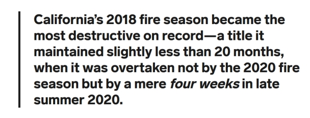
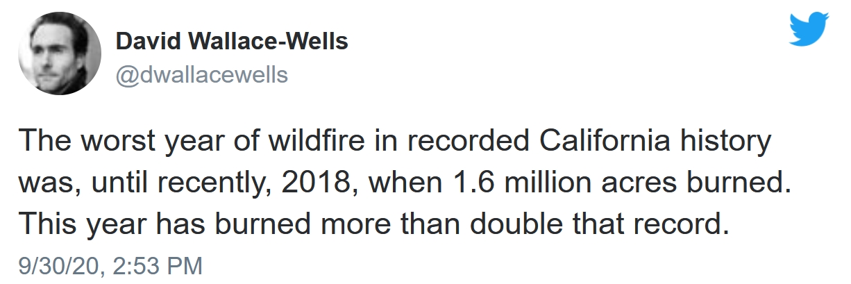
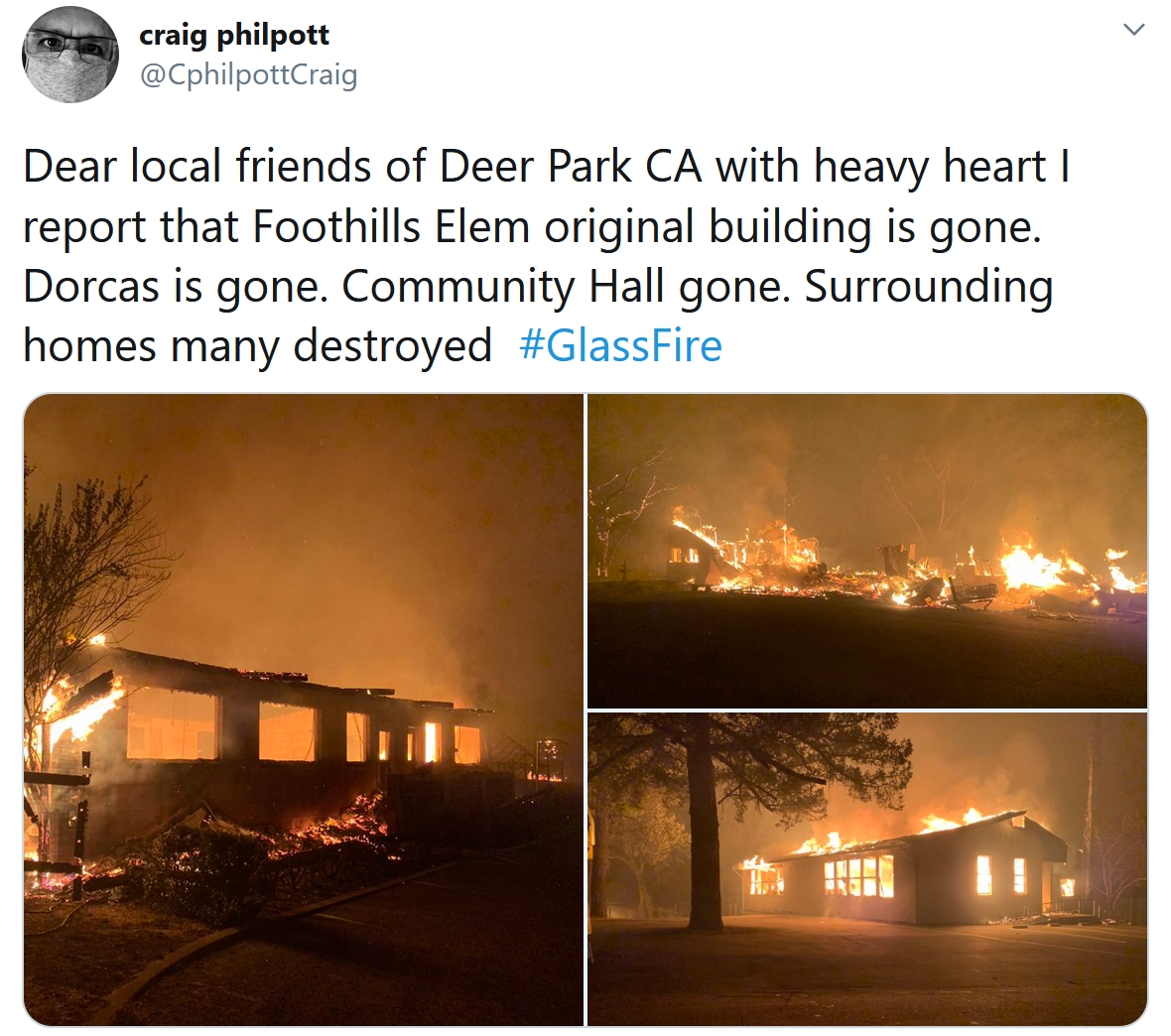
The West’s Infernos Are Melting Our Sense of How Fire Works. WIRED.com (paywall) provides needed perspective on what’s happening: “…In making sense of Western wildfires, total acres burned are far less important than the increasingly capricious violence of our most extreme blazes. It is as if we’ve crossed some threshold of climate and fire fuel into an era of uncontrollable conflagrations. “Not only is the size and severity increasing, but the nature of fire is changing,” says David Saah, director of Pyregence, a group of fire-science labs and researchers collaborating on the problem. Still more concerning, given the trend toward fires dramatically more catastrophic than anything we’ve yet seen: The physics of large-scale wildfires remain so poorly understood that fire-modeling software is often effectively powerless to predict where they will next occur, much less how they will unfold once they do. If there is any good news, it is that, as Saah puts it, “the science for a lot of this stuff is under way...”
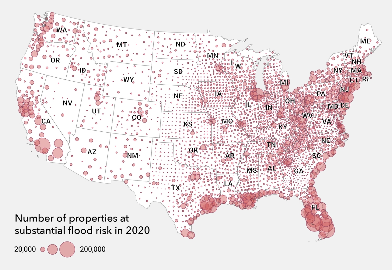
Homes Are Flooding Outside FEMA’s 100-Year Flood Zones, and Racial Inequality is Showing Through. Here’s a clip from a post at The Conversation: “…New research suggests that nearly twice as many properties are at risk from a 100-year flood today than the Federal Emergency Management Agency’s flood maps indicate. Unfortunately, many of the people living in those properties have no idea that their homes are at risk until the floodwaters rise. I am a sociologist who works on disaster vulnerability. In a new study, I looked at the makeup of communities in Houston that aren’t in the 100-year flood zone, but that still flood. What I found tells a story of racial disparities in the city. Research in other cities has shown similar flooding problems in predominantly Black and Hispanic neighborhoods...”
Map credit: First Street Foundation.

New Super-Enzyme Eats Plastic Bottles Six Times Faster. I hope whoever brings this to market makes trillions of dollars. The Guardian reports: “A super-enzyme that degrades plastic bottles six times faster than before has been created by scientists and could be used for recycling within a year or two. The super-enzyme, derived from bacteria that naturally evolved the ability to eat plastic, enables the full recycling of the bottles. Scientists believe combining it with enzymes that break down cotton would also allow mixed-fabric clothing to be recycled. Today, millions of tons of such clothing is either dumped in landfill or incinerated. Plastic pollution has contaminated the whole planet, from the Arctic to the deepest oceans, and people are now known to consume and breathe microplastic particles…”

Parrots in Wildlife Park Moved After Swearing at Visitors. Maybe they watched the debates? CNN Travel has a perfect metaphor for 2020: “Five parrots have been removed from public view at a British wildlife park after they started swearing at customers. The foul-mouthed birds were split up after they launched a number of different expletives at visitors and staff just days after being donated to Lincolnshire Wildlife Park in eastern England. “It just went ballistic, they were all swearing,” the venue’s chief executive Steve Nichols told CNN Travel on Tuesday. “We were a little concerned about the children...”

64 F. high in the Twin Cities on Wednesday.
65 F. average high on September 30.
86 F. high on September 30, 2019.
October 1, 1999: One of the earliest significant snowfalls in Minnesota history falls in a narrow track across southern Minnesota. Reported snowfall totals include 4.0 inches in Montgomery (Le Sueur County) and Northfield (Rice County), 3.8 inches in Springfield (Brown County), 3.0 inches in Vesta (Redwood county), and 2.8 inches in Mankato (Blue Earth County).
October 1, 1989: High temperatures across central and southern Minnesota reach the 80’s. Later in the day, a cold front would come through and drop the mercury to the 40’s.
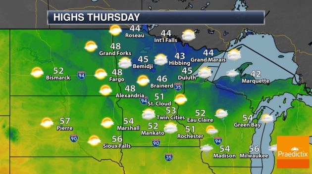
THURSDAY: Chilly, few showers. Winds: NW 10-20. High: 53
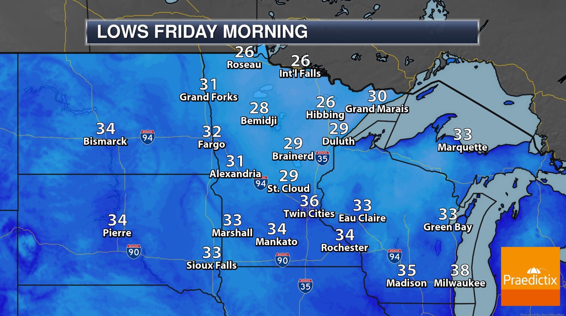
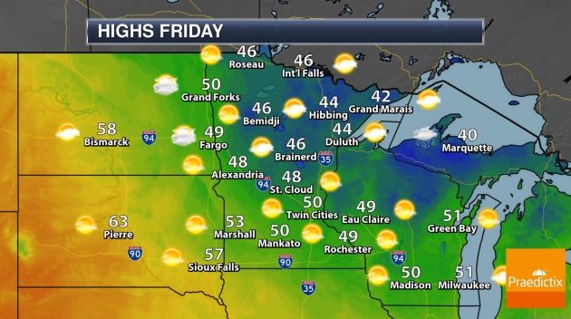
FRIDAY: Mostly cloudy, winds ease. Winds: NW 8-13. Wake-up: 37. High: 49
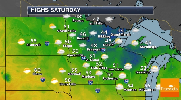
SATURDAY: Mostly cloudy, stray shower possible. Winds: NW 5-10. Wake-up: 38. High: 52
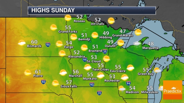
SUNDAY: Partly sunny, a little nicer. Winds: NW 7-12. Wake-up: 36. High: 57
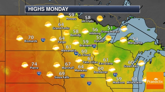
MONDAY: Intervals of sun, a milder breeze. Winds: S 10-20. Wake-up: 44. High: 62
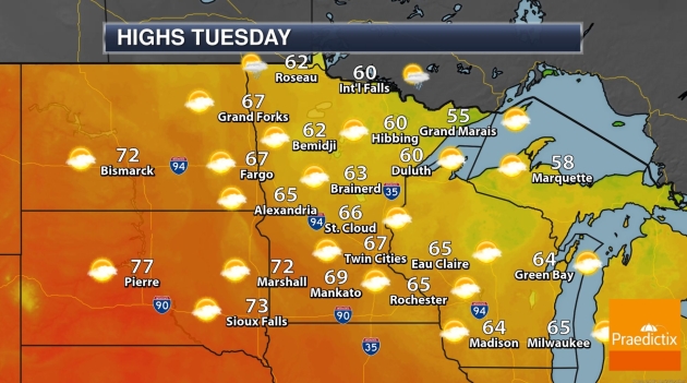
TUESDAY: Milder with a passing T-shower. Winds: W 8-13. Wake-up: 49. High: 68
WEDNESDAY: Windy with a mix of clouds and sun. Winds: NW 15-25. Wake-up: 46. High: 59
Photo credit: Susan Marmot.