
Bright Sunshine Melts Some Of Our Snow
Well that was fun. Storms (temporarily) distract me from viruses and politics. And – I’m bored and insecure – they give me something to point to.
Over the years I’ve noticed that 3-6 inches of snow instills more angst in November than it does in March. By early spring our attitude is “that’s all you got?”
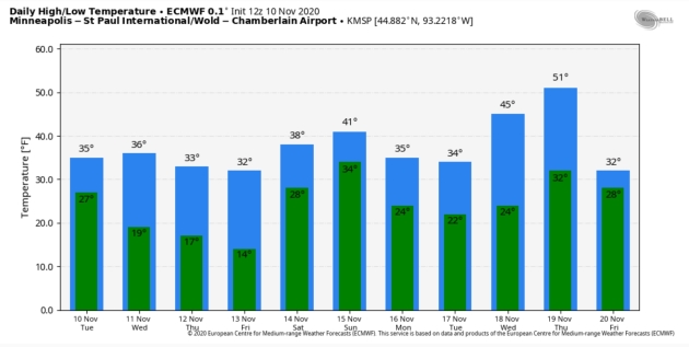
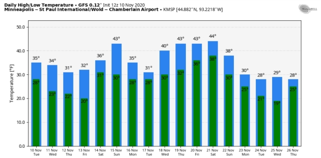
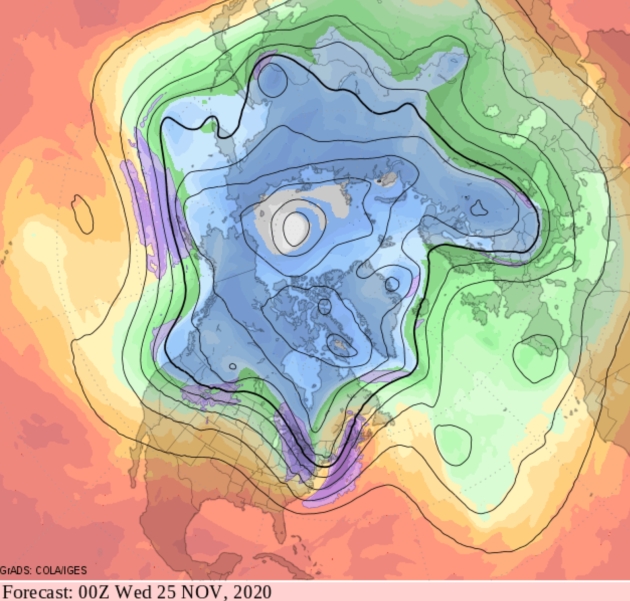
In spite of morning slush, I still see a mild, Pacific signal deep into November. Rough rule of thumb: when Alaska is cold and snowy – Minnesota trends milder. Models show a chilly, stormy pattern for the western U.S. into Thanksgiving, which suggests relatively quiet weather east of the Rockies, and temperatures close to normal. I don’t think we’ve seen our last 50 yet, either.
No harrowing storms in sight, just welcome sunshine today, a few snow showers Thursday, maybe a little slush or ice early Saturday. Models suggest a slight warming trend next week.
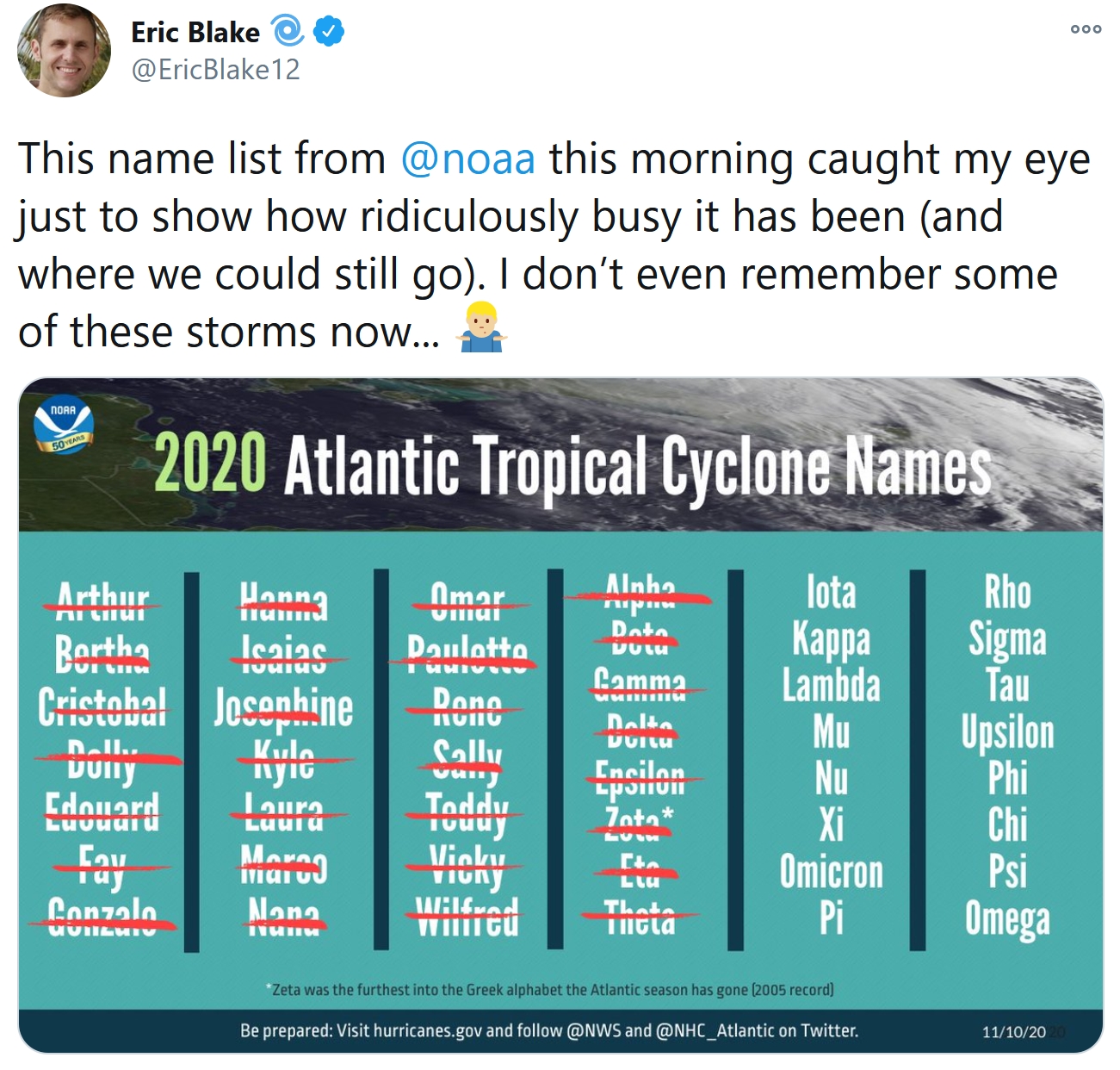
Meanwhile “Eta” may take a second pass at Florida by Saturday. Now there’s Tropical Storm Theta in the Atlantic. I’m getting sick of the Greek alphabet.
Image credit: NOAA.
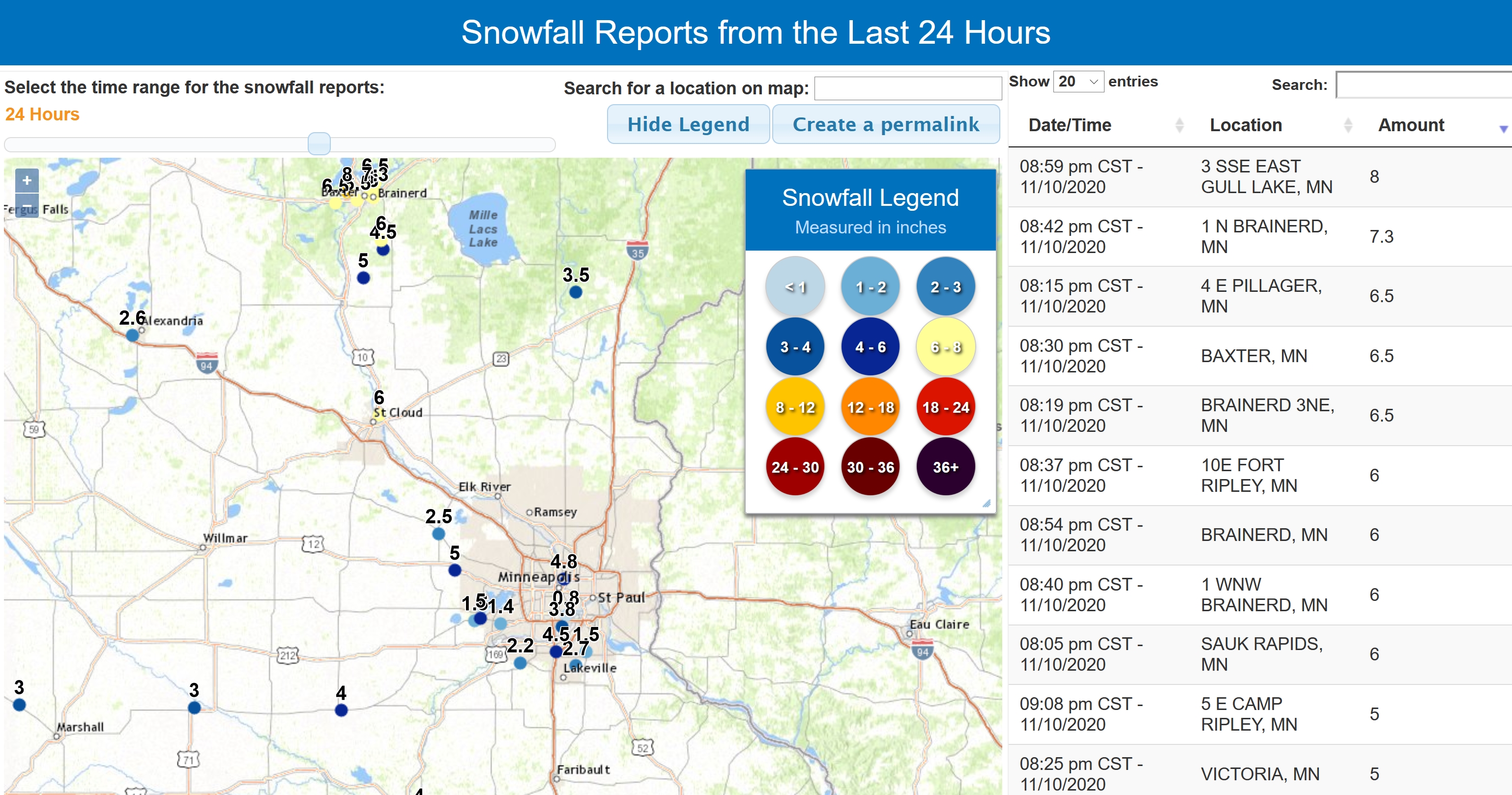
Snowfall Totals. Generally 3-6″ from last night’s snow burst, give or take. Click here for updated totals, courtesy of the Twin Cities National Weather Service.


Praedictix Briefing: Issued Tuesday, November 10th, 2020:
Upper Midwest Snow And Ice
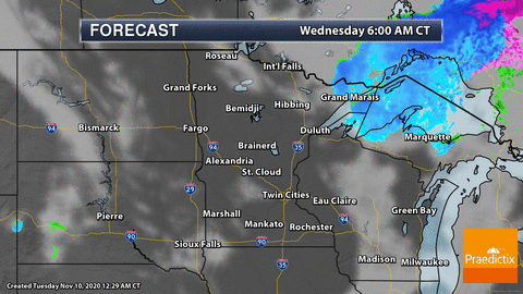
Morning Radar:

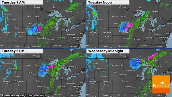
Winter Storm Potential. After a cold front moved through the upper Midwest yesterday, a second storm is taking aim on the region today bringing a batch of ice and heavy snow along with it. Precipitation is falling across portions of the region this morning and will continue to move northeast throughout the day. The best chance of icing will be from eastern Nebraska into southern Minnesota, with snow stretching from central Nebraska to the Arrowhead of Minnesota. In Omaha, rain is falling this morning, but it should change over to a wintry mix around the midday hours. In the Twin Cities, precipitation will start in the midday hours as potentially a rain/snow mix, changing to all snow into the evening hours, ending shortly before midnight. The snow in the Twin Cities could be heavy at times this evening.
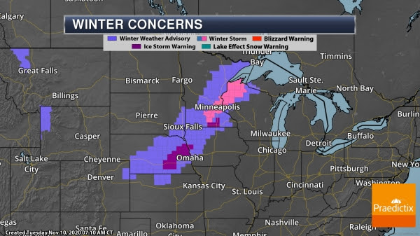
Alerts In Place. Ice Storm Warnings, Winter Storm Warnings and Winter Weather Advisories stretch from eastern Colorado and northern Kansas to Lake Superior. Breaking down some of the larger cities across the region:
- Ice Storm Warnings in Nebraska/western Iowa: Through 3 PM for up to a quarter inch of ice.
- Ice Storm Warnings in southern Minnesota: Through 6 PM for up to quarter inch of ice.
- Omaha, NE: Winter Weather Advisory until 3 PM for some slight ice or snow accumulation.
- Sioux Falls, SD: Winter Weather Advisory from 8 AM through 9 PM for 2-6” of snow.
- Minneapolis, MN: Winter Storm Warning until Midnight tonight for 4-7” of snow.
- Duluth, MN: Winter Weather Advisory from 5 PM today through 4 AM Wednesday for 4-6” of snow.
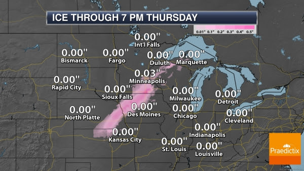
Ice Forecast. While a strip of accumulating ice will be possible today from northern Kansas to northern Wisconsin, the heaviest will be in portions of eastern Nebraska, western Iowa, and southern Minnesota where up to around a quarter inch of ice will be possible. This will cause slippery conditions with hazardous travel possible.
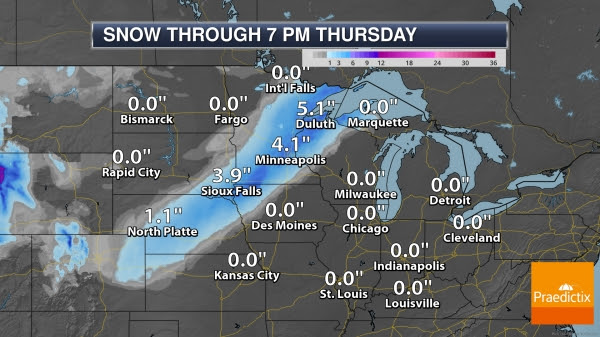
Snow Forecast. Heavy snow will also be possible with this storm, with a few areas of 6”+ possible across portions of northwestern Iowa/southwestern Minnesota and northern Wisconsin.
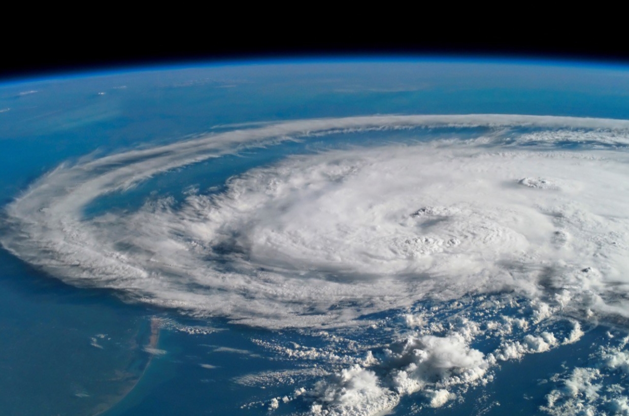
Tropical Storm Eta
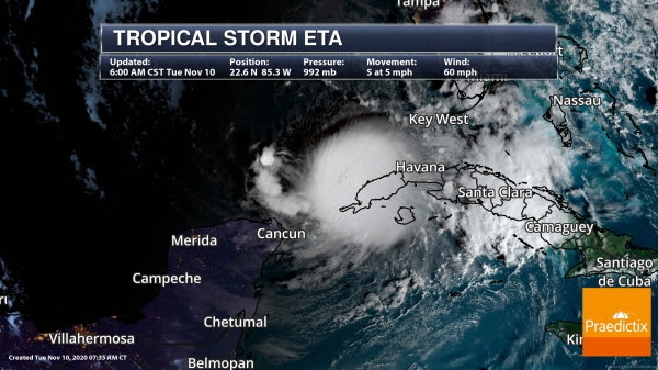
Eta As Of Tuesday Morning. Eta has made it south to near western Cuba this morning. While some weakening had occurred with Eta over the past 24 hours, re-strengthening has started. As of the 6 AM CT update from the National Hurricane Center, Eta had winds of 60 mph. The center of Eta was positioned 60 miles northwest of the western tip of Cuba and moving south at 5 mph.
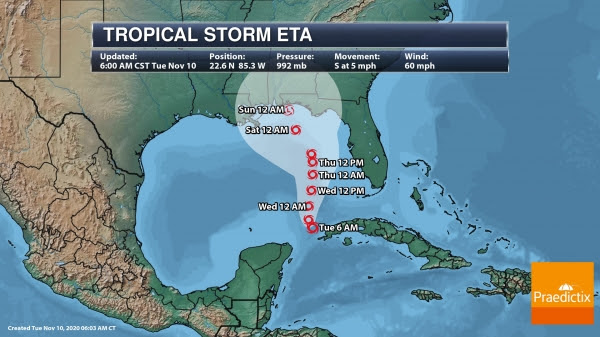
Eta Track. While Eta has been slowly moving south this morning, it is expected to become stationary later today. We should start to see Eta start slowly moving north tonight, continuing over the next few days. The track of Eta has changed over the past day, with the system now expected to move toward the Florida panhandle into the weekend – however, models are all over the map in regards to the track of Eta once we get more than a couple days out, so there is a lot of uncertainty to the future of the storm. If it does take the current forecast track, we should see some strengthening over the next 24-48 hours followed by weakening. By the time it approaches the Gulf Coast, Eta could be a tropical depression.
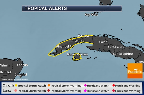
Tropical Storm Alerts. Tropical Storm Watches remain in place for the Cuban provinces of La Habana, Artemisa, Mayabeque, Pinar del Rio, and the Isle of Youth.
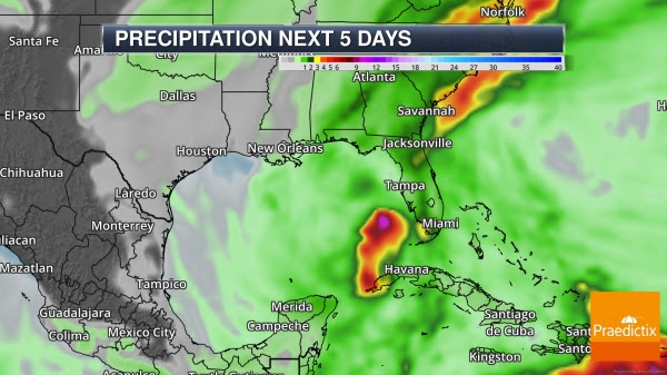
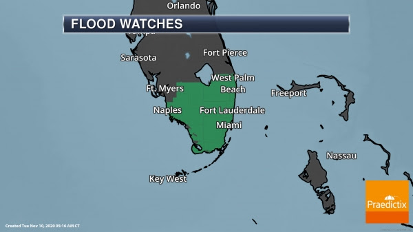
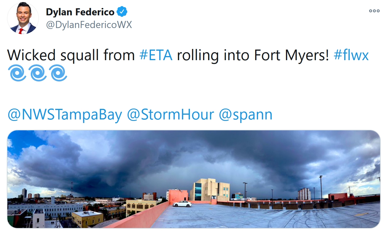
Heavy Rain And Flooding. Heavy rain will continue across portions of western Cuba and southern Florida over the next few days that could lead to flooding. Here’s a look at the potential rainfall amounts over the next few days according to the National Hurricane Center:
- Western Cuba: an additional 3 to 5 inches (75 to 125 mm), with isolated maximum storm total accumulations of 25 inches (765 mm).
- South Florida: an additional 1 to 2 inches (25 to 50 mm), with isolated maximum storm total accumulations of 20 inches (510 mm).
-
Other Atlantic Concerns
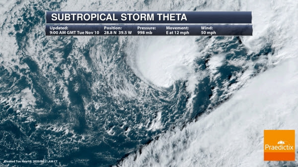

Subtropical Storm Theta. The 29th named storm of the record-breaking Atlantic hurricane season formed Monday night across the eastern Atlantic. The good news is that Theta won’t be a threat to land until this weekend when it could approach Madeira.
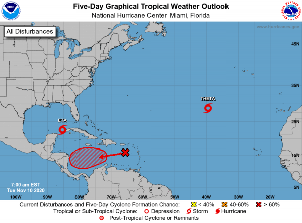
Caribbean Threat. We’re also tracking a tropical wave in the eastern Caribbean Sea that will continue to move west this week. As we get toward the late week or weekend time frame we could see a tropical depression form over the central or western Caribbean. There is a 70% chance of formation in the next five days.
Vamco In The Western Pacific


Latest On Vamco. We’re also keeping an eye on Vamco (also known as Ulysses in the Philippines) which looks to impact portions of the Philippines, including Manila, later this week. We still expect to see Vamco strengthen over the next day or so as it approaches the Philippines, with wind speed around 105 mph as the system approaches Manila later Wednesday into early Thursday. According to PAGASA-DOST, Vamco will bring strong winds across the northern Philippines, with Tropical Cyclone Wind Signal #1 in place for Manila, and Tropical Cyclone Wind Signal #2 in place for portions of Luzon, Visayas, and Mindanao. Heavy rain will also bring the threat of flooding, landslides, and sediment-laden streamflows. There is also a moderate to high risk of a storm surge of 1-2 meters in coastal areas including metro Manila. You can read the latest statement from the PAGASA-DOS here: bagong.pagasa.dost.gov.ph/tropical-cyclone/severe-weather-bulletin/2
D.J. Kayser, Meteorologist, Praedictix.

Effective Government Saves Lives in Cyclones, Other Disasters. Makes sense to me, good government and warning systems in place to cut through the noise so people take meaningful action to protect their properties and their lives. Here’s a clip from ScienceDaily: “…There are many examples indicating that strong institutions — including government — play a critical role in protecting populations from adverse effects of natural disasters, Tennant said. But it is much more difficult to determine how universal this relationship is, she said, because there is so much variation in the frequency and severity of storms. Natural hazards such as cyclones, the researcher wrote, result in disasters only when vulnerable human systems are exposed to hazardous conditions. In their analysis, Tennant and Gilmore explicitly accounted for hazard exposure, connecting the analysis of governance and other indicators of well-being to estimates of the severity and exposure to the tropical cyclone hazard…”
File Image: NASA.
32 F. maximum temperature in the Twin Cities on Tuesday.
45 F. average high on November 10.
33 F. high on November 10, 2019.
November 11, 1940: The Great Armistice Day Blizzard kills 49 people in Minnesota. Food dropped by Pilot Max Conrad saved stranded hunters. The barometer fell to 28.66 inches at Duluth. Some roads were so badly blocked with snow they weren’t opened until Nov. 22.
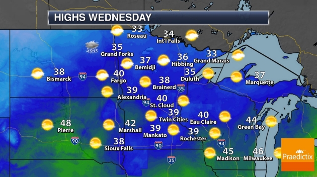
WEDNESDAY: Sunny and cool. Winds: SW 10-15. High: 35
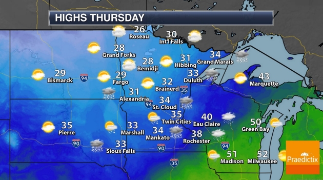
THURSDAY: Few showers of rain or wet snow. Winds: NW 10-15. Wake-up: 26. High: 34
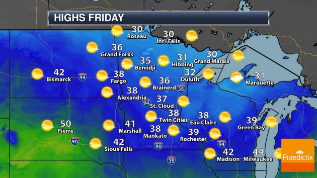
FRIDAY: Plenty of sunshine. Winds: S 8-13. Wake-up: 21. High: 33
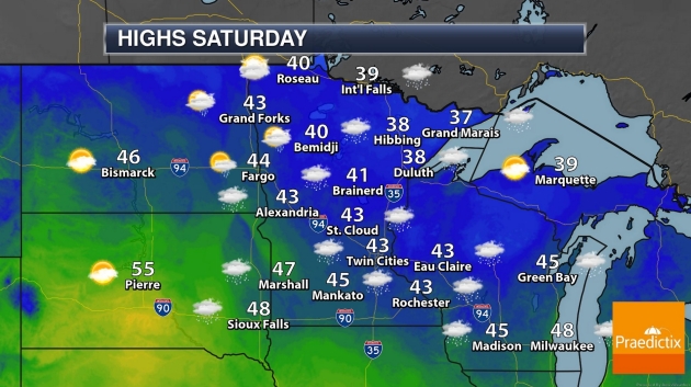
SATURDAY: Early slush or ice, then clearing. Winds: SE 10-20. Wake-up: 30. High: 39
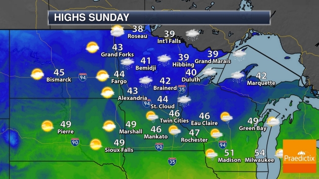
SUNDAY: Wind-whipped clouds, few flakes. Winds: NW 15-25. Wake-up: 33. High: 41
MONDAY: Few sunny breaks, brisk. Winds: NW 10-20. Wake-up: 28. High: 35
TUESDAY: Blue sky, light winds. Winds: SE 5-10. Wake-up: 22. High: 33
Climate Stories…
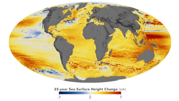
NASA Watches Sea Level Rise from Space, and Its Centers’ Windows. NASA has a post; here’s an excerpt: “…Kelemen says the data coming from scientists both at NASA and from outside the agency is alarming. The most conservative estimates predict at least a 15-inch sea level rise by 2080 but indicate a much greater impact if the rate of sea level rise continues accelerating as it has done in past decades. For Langley, sea level rise concerns are compounded by area subsidence – a sinking of the landmass below the facilities. Precision measurements at NASA Langley show it is sinking 0.08 inches (2 millimeters) a year, which means its effective rate of sea level rise is closer to 0.24 inches (6 millimeters) per year…”
Map credit: “This map shows the change in sea level between 1992 and 2014 measured by the TOPEX/Poseidon, Jason-1, Jason-2, and Jason-3 missions.” Credits: NASA Scientific Visualization Studio images by Kel Elkins, using data from JASON-1, JASON-2, and TOPEX/Poseidon.
What Will Trump’s Most Profound Legacy Be? Possibly Climate Damage. The New York Times (paywall) has the story; here is the intro: “President-elect Joseph R. Biden Jr. will use the next four years to try to restore the environmental policies that his predecessor has methodically blown up, but the damage done by the greenhouse gas pollution unleashed by President Trump’s rollbacks may prove to be one of the most profound legacies of his single term. Most of Mr. Trump’s environmental policies, which erased or loosened nearly 100 rules and regulations on pollution in the air, water and atmosphere, can be reversed, though not immediately. Pollutants like industrial soot and chemicals can have lasting health effects, especially in minority communities where they are often concentrated. But air quality and water clarity can be restored once emissions are put back under control...”
Photo credit: “ Credit: Erin Schaff/The New York Times.
File image: NASA.

How Joe Biden Plans to Use Executive Powers to Fight Climate Change. More perspective in a post at Vox: “…But Biden’s most ambitious ideas — particularly using $1.7 trillion in government money — requires Congress to go along, and it’s not clear he’ll have a willing majority. Even a narrow Democratic majority could be thwarted by the filibuster. Biden is also likely to undo most, if not all, of Trump’s environmental rollbacks with his executive powers. Trump has repealed or weakened 125 environmental regulations, like protections for endangered species and environmental risk assessments for infrastructure, and has opened protected wilderness for fossil fuel development and logging. Some of the most notable rollbacks are of rules seeking to cut greenhouse gases, like the Clean Power Plan, energy efficiency standards, and fuel economy regulations for cars and trucks. Many of these rollbacks are also tied down in ongoing lawsuits across state and federal courts that may take months to resolve...”
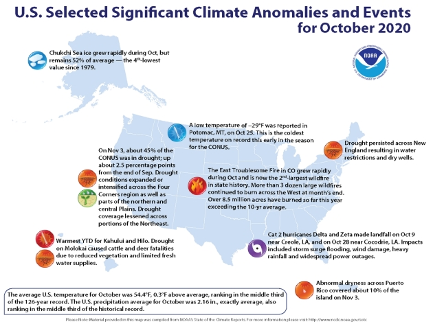
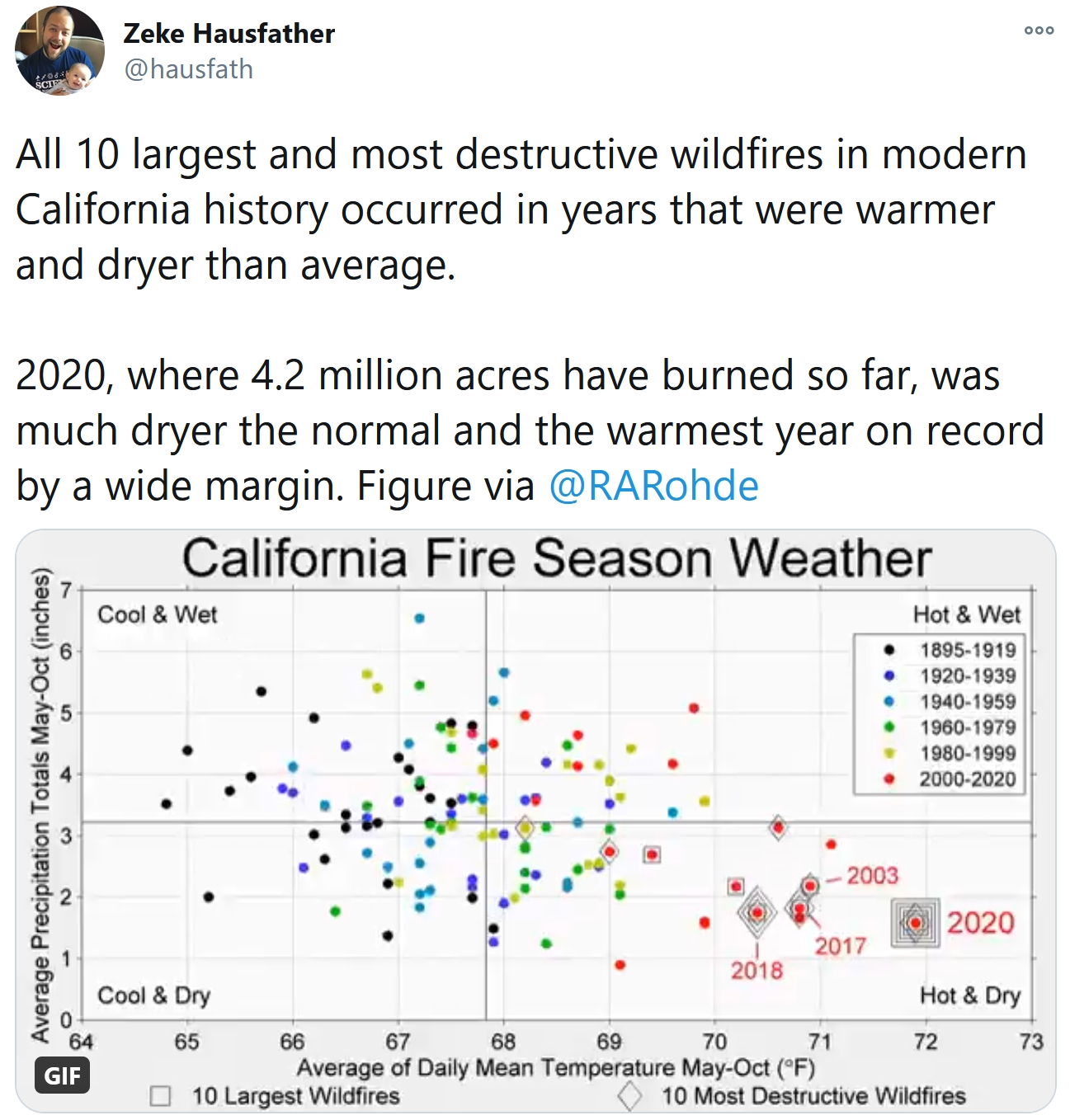
Notable Weather and Climate Events in October. It’s a long list; here’s an except from phys.org: “…Record wildfires scorched the West: Colorado had its three-largest wildfires in state history last month—the Cameron Peak, Pine Gulch and East Troublesome fires. In particular, the East Troublesome fire spread rapidly to more than 193,000 acres. Wildfires also grew explosively in California, with nearly 100,000 Orange County residents evacuating as the Silverado and Blue Ridge fires burned. Historic tropical activity in the Atlantic: Through October 31, 11 named Atlantic tropical cyclones have made landfall in the U.S. this hurricane season, breaking the previous record of nine landfalls in 1916. In October alone, Hurricanes Delta and Zeta both struck Louisiana just a few weeks apart...”
Image credit: NOAA.

A Bipartisan Climate Policy? It Could Happen Under a Biden Administration, Washington Veterans Say. Here’s a clip from InsideClimate News: “…But industry and environmental advocates alike say that Biden, who spent more than 40 years in the Senate, is uniquely suited to the challenge of dealing with McConnell—and with former colleagues of both parties. They are anticipating that Biden will be able to do more in the face of a hostile Congress than did President Barack Obama, who relied on a series of executive actions on climate that President Donald Trump has spent the past four years overturning. Climate policy watchers expect Biden to engage Capitol Hill on green stimulus and Covid relief, including measures that already enjoy bipartisan support like infrastructure, farm aid and support for renewable energy and carbon capture and storage. And perhaps, packaged with the right incentives, that might even include economy-wide legislation that puts a price on carbon. At least one Capitol Hill veteran argues that partisan disadvantage may be an advantage in the long run, for the stability of climate policy…”
Joe Biden Will Be President – But There Will Be No Green New Deal. So says writers at Vox; here’s an excerpt that caught my eye: “…But there is an enormous amount that Biden can do with the presidency alone. He can immediately begin reversing Trump’s massive deregulatory moves, restoring the more than 125 rules Trump has reversed or weakened. He can instruct the Environmental Protection Agency to develop a more ambitious version of Obama’s Clean Power Plan for the electricity sector, to work toward his goal of net-zero emissions electricity by 2035, and the Department of Transportation to develop, as his plan promises, “rigorous new fuel economy standards aimed at ensuring 100% of new sales for light- and medium-duty vehicles will be electrified.” He can grant California the waiver it needs (which Trump is now in court trying to block) to pursue its own ambitious vehicle standards...”

Biden Shift on Climate Change Welcomed by World Leaders. Financial Times reports: “…However, Mr Biden’s domestic climate agenda could be challenged if the Republican party retains control of the Senate, which will be decided by two run-off elections in Georgia in January. Paul Bledsoe, strategic adviser at the Progressive Policy Institute, and a former climate adviser in the Clinton White House, said Mr Biden could lean more on regulatory measures to enact his environmental agenda, if he were unable to pass climate legislation. “Trump overturned over 100 major environmental regulations. Many of those will be reinstated,” said Mr Bledsoe. Vehicle emissions standards, which were watered down under the Trump administration, could be one of the first areas to be revived…”

The Climate Technologies Venture Capitalists are Backing. Yes, there will be plenty of money to be made cleaning things up; here’s the intro to analysis at Quartz: “The world needs to invest about $3.5 trillion per year to keep global average temperatures from rising to dangerous levels, according to the Intergovernmental Panel on Climate Change. So far, we’re not even close. Despite a record $370 billion investment in wind and solar last year, that’s just a fraction of what’s necessary to decarbonize the energy sector. Most of the trillions needed will go toward scaling up known technologies—solar, wind, batteries, smart grids, transmission lines, and energy efficiency—but those fixes have their limits…”

Wall Street Braces for Climate Change Scrutiny Under Biden. POLITICO reports: “Big Wall Street banks, facing the prospect that Democrats will impose new rules to force lenders to deal with natural disasters and rising sea levels, are positioning themselves as eager allies with a Joe Biden administration in fighting climate change. Banks are accelerating efforts to get ahead of the issue and make clear to Biden’s team that they want a place at the table when decisions are made. JPMorgan Chase, Bank of America, Citigroup and Goldman Sachs are among the firms that have committed to hundreds of billions of dollars’ in investments that they say will reduce carbon emissions. The head of the Institute of International Finance, which represents global financial firms, pledged to Biden economic adviser Jared Bernstein that the industry would be “a willing and active partner” on climate…”