
A Quiet, Lukewarm Pattern for Minnesota
Climate refugees? Maybe Bangladesh or the Maldive Islands in the Pacific, but here in the U.S.?
As a warming climate makes naturally-occurring fires, floods and hurricanes more intense experts predict a slow-motion migration away from high risk areas in the south and west.
A recent story at The New York Times outlines the trends and predictions: s many as 13 million Americans could be forced to move away from submerged coastalines. 28 million Americans may face “mega-fires” as summers heat up, making work outside increasingly difficult. Access to clean, reliable water will be a major theme of the 21st century. Many of these people will be moving north. Oddly enough, Minnesota may benefit from a flight to cooler climes.
Mercifully, our weather weather will be downright benign into next week. Comfortably cool weather is on tap into Friday with spurts of sunshine. Clouds increase Saturday ahead of a warmer front. Models still show a string of 70s next week, with an outside shot at 80F.
Your begonias are not in grave danger. No frost at MSP looking out at least 2 weeks.
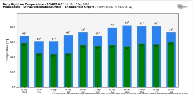
MSP Meteogram above from ECMWF: WeatherBell.
Smoky Skies: September 13-15, 2020. The Minnesota DNR has more perspective on our recent run-in with smoke from western fires: “Smoke from western wildfires cause filtered sunshine over Minnesota. Smoke and haze from the wildfires over California, Oregon and Washington drifted over Minnesota and was the thickest from the September 13th to the 15th, 2020. The smoke was at higher elevations and did not affect visibility near the ground. The visibility at the Twin Cities International Airport was ten miles for the whole period. The sun appeared as a pale disk at times and had some spectacular orange and red hues closer to sunset. The smoke did cut down a bit on solar radiation. Looking at the graph included with this article, a perfectly sunny day for mid-September would have peak hourly average solar radiation around 1.1 Langleys per minute...”
Image credit: NOAA.
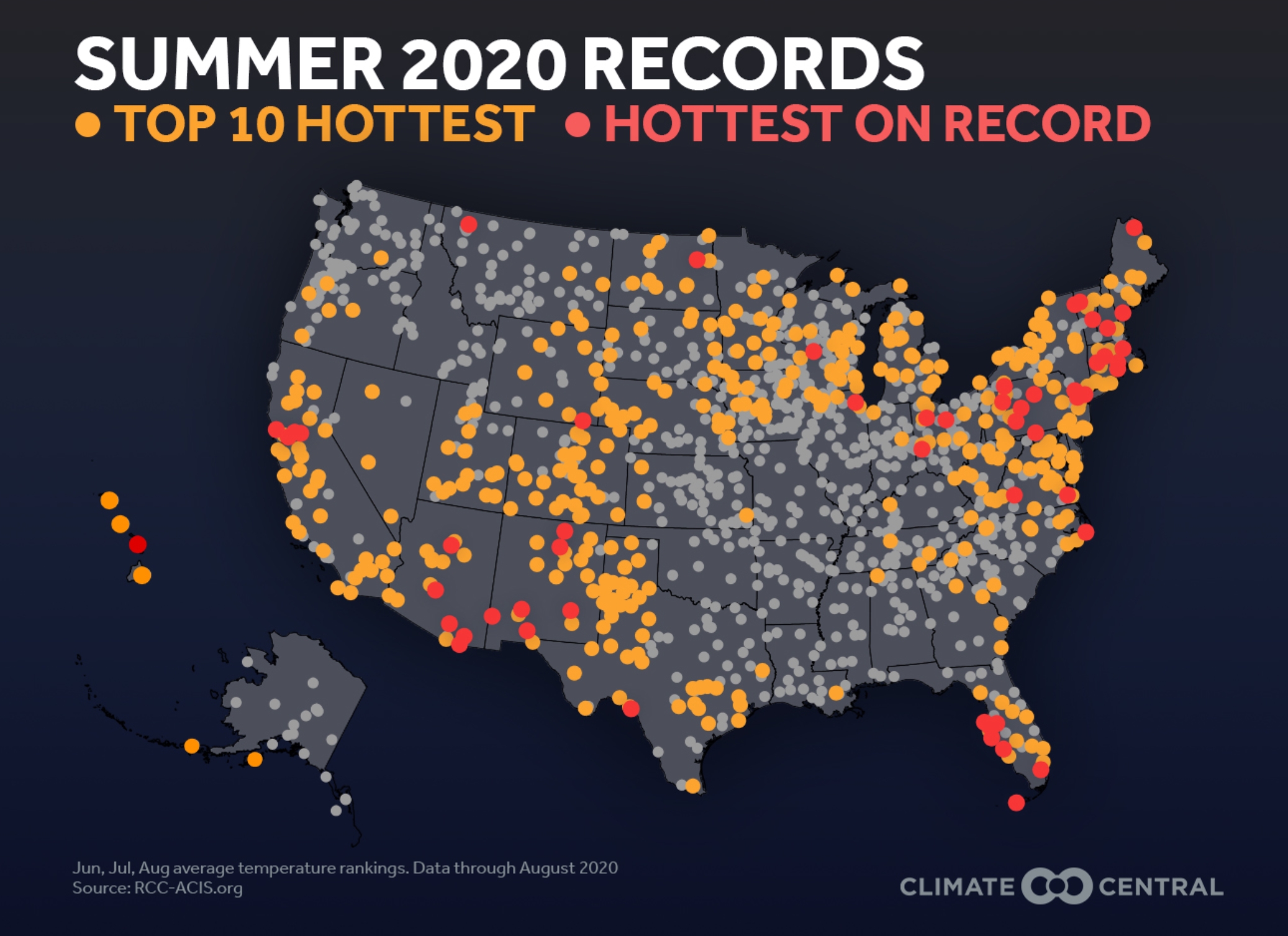
Hottest Summer on Record. Minnesota experienced the 4th warmest and 17th wettest meteorological summer on record. For a broader scope Climate Central has details: “…Summer 2020’s heat is one for the record books. It was the fourth-hottest summer on record for the contiguous U.S. and third-hottest June-August period globally. Many cities in the Southwest, Southeast, Mid-Atlantic, and Northeast either broke or tied their records for their hottest summer to date. Investigating this further, Climate Central uncovered that summer 2020 was within the top 10 hottest summers for 37% (452) of 1,203 cities analyzed, and 55 cities had their hottest summer on record…”
Praedictix Briefing: Issued Wednesday, September 16th, 2020:
Hurricane Sally
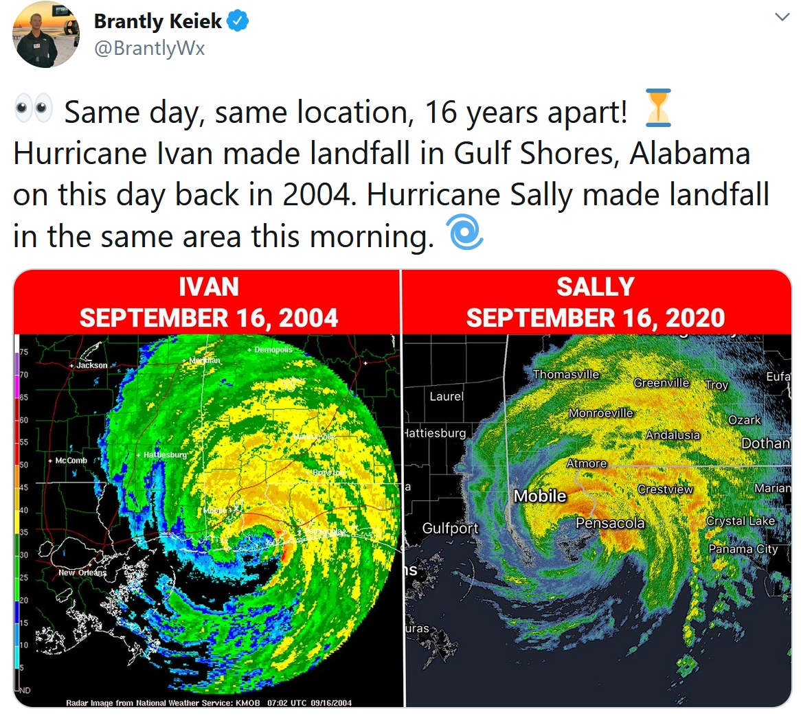
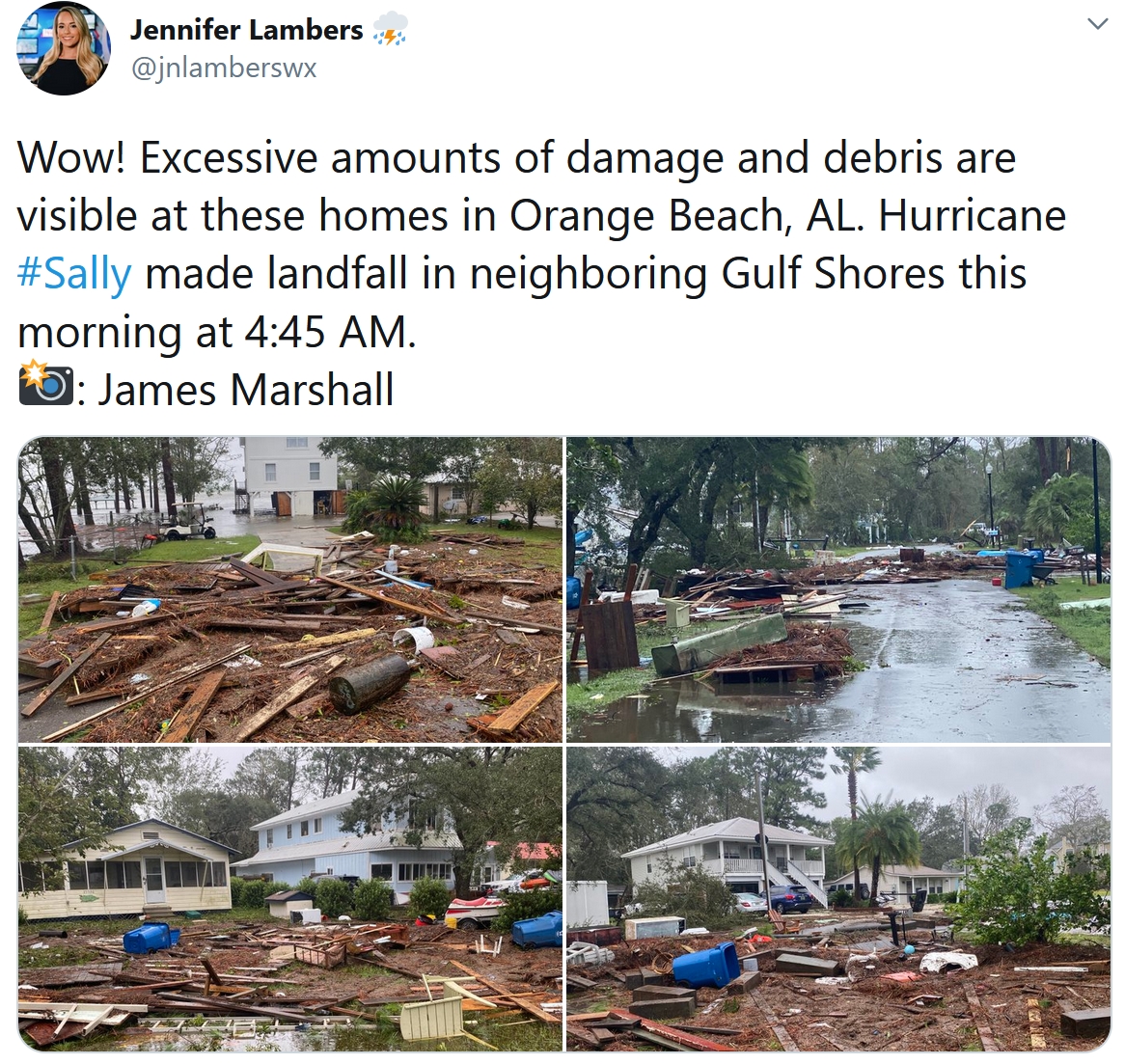
Big Headline: Sally strengthened overnight before making landfall near Gulf Shores, AL, as a Category 2 hurricane with winds of 105 mph around 4:45 AM. Sally will weaken as it slowly moves inland today, but will continue to produce very heavy rain, life-threatening flooding, and dangerous storm surge.
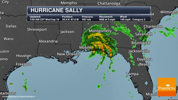
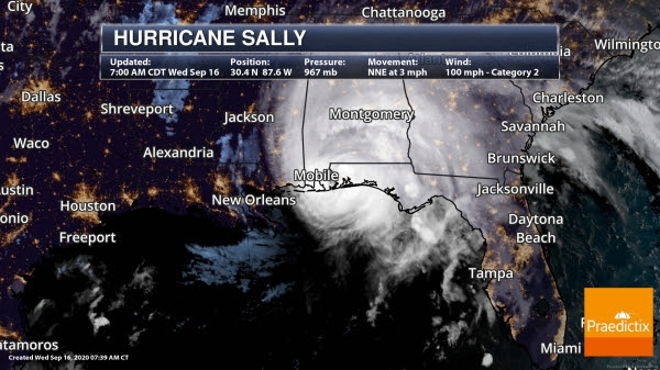
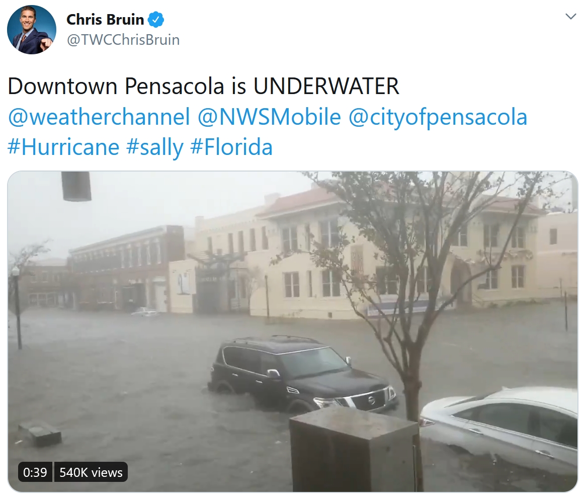
Hurricane Sally. As mentioned above, we did see some strengthening overnight as Sally approached the Gulf Coast, becoming a Category 2 hurricane with winds of 105 mph before the system made landfall near Gulf Shores, AL, at 4:45 AM. This morning we did see a wind gust to 99 mph at Dauphin Island, AL, a 93 mph gust at a University of Florida weather tower in Gulf Shores, a gust of 86 mph at the Pensacola Naval Air Station, and a gust of 81 mph in Mobile. As of the 7 AM CDT update from the National Hurricane Center, Sally still had winds of 100 mph. The center of circulation was located 15 miles north-northeast of Gulf Shores, AL, or 25 miles west-southwest of Pensacola, FL, and the system was moving north-northeast at 3 mph.
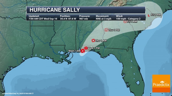
Sally Track. Sally will continue to slowly move inland today to the north-northeast, weakening as it does so. As we head into tonight, we should see a forward increase in speed and the system moving more northeast. On this track, Sally will move across portions of the western Florida Panhandle and southern/eastern Alabama today into early Thursday, moving across Georgia Thursday into Thursday Night, and then across South Carolina Friday. Sally will weaken into a tropical storm later today or early tonight, then into a tropical depression by Thursday afternoon. This system should be a remnant low over South Carolina Friday before dissipating. This system will continue to produce strong winds (especially near the Gulf Coast), very heavy rain, potentially life-threatening flooding, and dangerous storm surge.
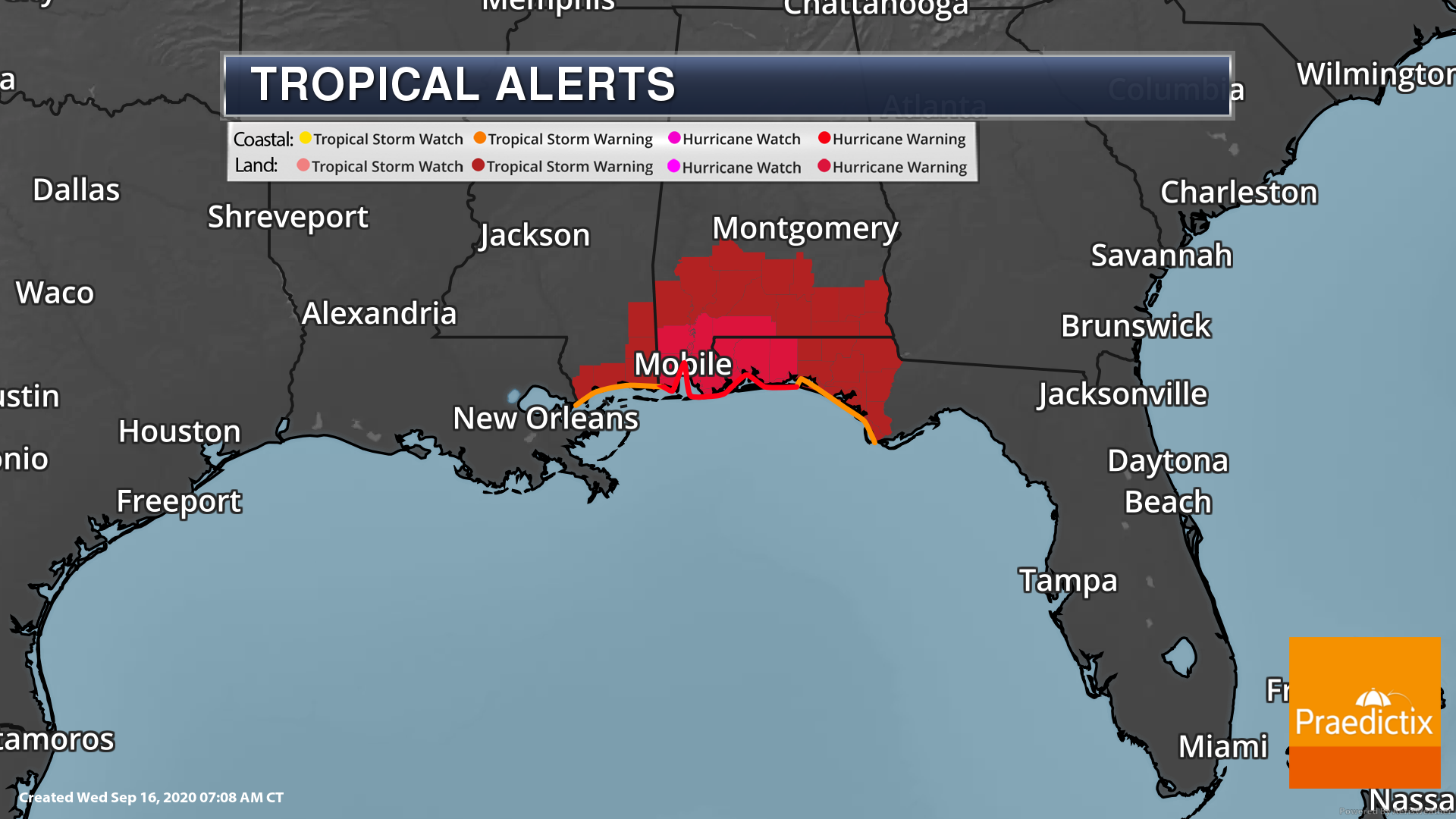
Hurricane Alerts. Hurricane and Tropical Storm Warnings are still across portions of Mississippi, Alabama, and the Florida Panhandle due to Sally. Along the coast, they include the following areas:
A Hurricane Warning is in effect for…
* Mississippi/Alabama border to the Okaloosa/Walton County line, Florida
A Tropical Storm Warning is in effect for…
* East of the Okaloosa/Walton County line Florida to Indian Pass, Florida
* Mississippi/Alabama border to the Mouth of the Pearl River
Cities that are under Hurricane Warnings include Mobile and Pensacola. Cities under Tropical Storm Warnings include Biloxi, Dothan, and Panama City.
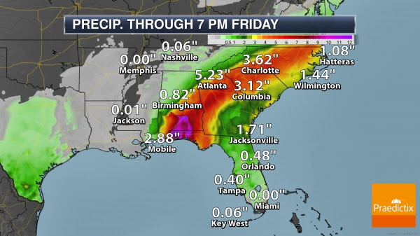
Additional Heavy Rain. The slow-moving nature of Sally will continue to lead to very heavy rain across the central Gulf Coast. Additional rainfall amounts today of 8-12” are expected from west of Tallahassee to Mobile Bay, where storm total rains of 10-20” (isolated 35”) are expected. This will lead to major (potentially historic) flooding across the region. As Sally turns northeast, the storm is expected to produce the following rain amounts, which could lead to flooding:
- Southern and central Alabama to central Georgia: 4-8”, isolated 12”
- Western South Carolina into western and central North Carolina: 4-6”, isolated 9”
- Southeast Virginia: 2-5”, isolated 7”
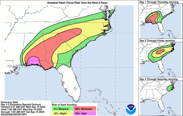
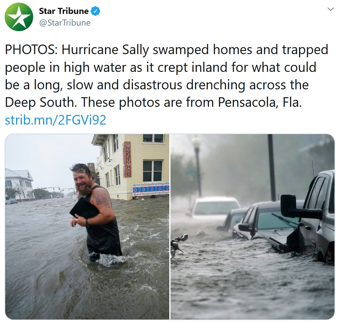
Historic Flooding Expected. Due to the heavy rain and widespread flash flooding expected with Sally today along portions of the Gulf Coast, a High Risk of Flash Flooding has been issued by the Weather Prediction Center. Rainfall rates of 3-4”+ are expected within the eyewall and feeder bands, which will continue to bring the threat of major, historic, and catastrophic flooding. The threat of flooding will continue to move inland with Sally through the end of the week.

Flood Watches. Flood Watches extend from the north-central Gulf Coast into southern Virginia due to Sally and the expected rain with the system over the next few days.
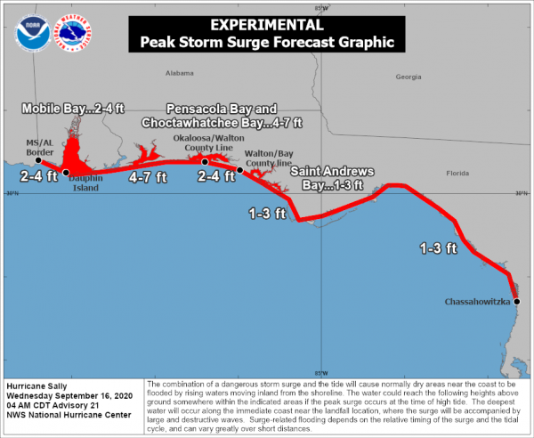
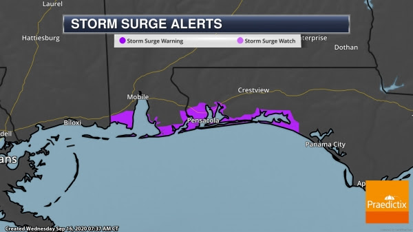
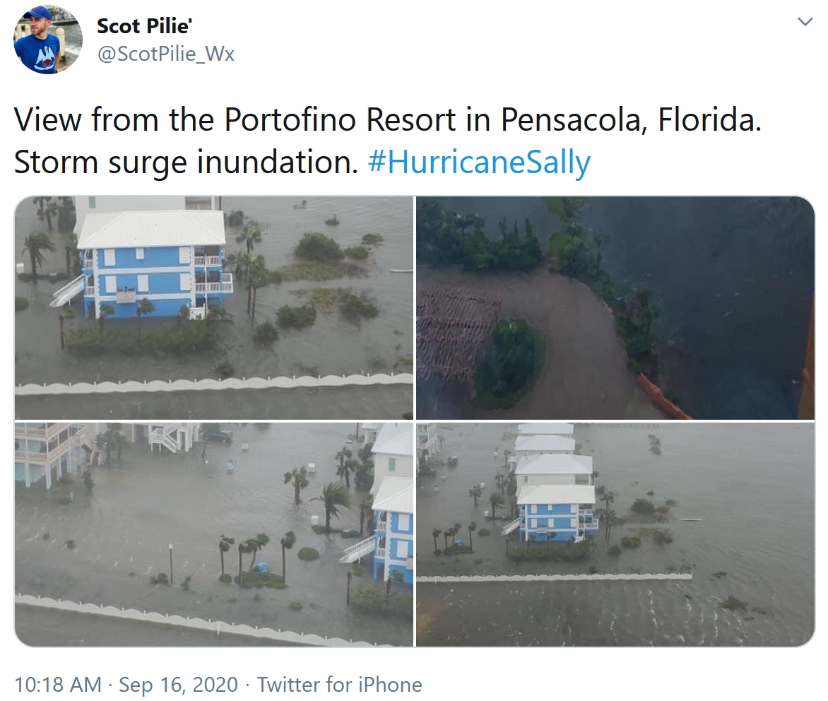
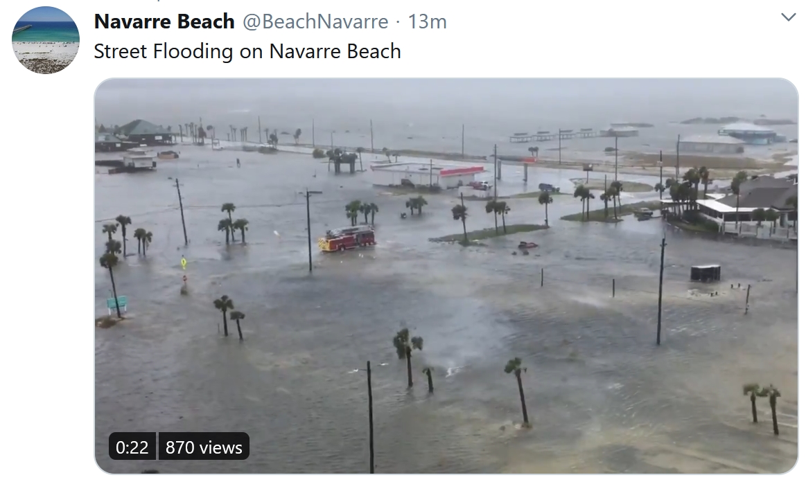
Dangerous, Life-Threatening Storm Surge Expected. A dangerous and life-threatening storm surge is still possible with Sally along the northern Gulf Coast today. The highest storm surge today of 4-7 feet is expected to occur near and to the east of where landfall occurred from the Alabama/Florida border to Okaloosa/Walton County, FL, including Pensacola Bay and Choctawhatchee Bay if the peak surge occurs at high tide. Large waves and the expected heavy rain adding more water to the region could also worsen some of the storm surge impacts. High tide today occurs either late in the morning hours or early in the afternoon. In Pensacola Bay, high tide today is at 11:08 AM. Storm Surge Warnings remain in place from Dauphin Island, AL, to the Walton/Bay County Line, FL.
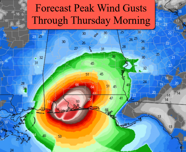
Peak Wind Forecast. The strongest winds – topping hurricane force – will be across southern Alabama and the western Florida Panhandle today (particularly this morning). As Sally continues to move inland, the winds with Sally will weaken.
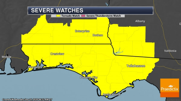
Tornado Watch. Landfalling tropical systems typically produce tornadoes, and due to that threat a Tornado Watch is in place across southern Alabama, the Florida Panhandle, and southwestern Georgia through 6 PM CDT.
Other Tropical Activity
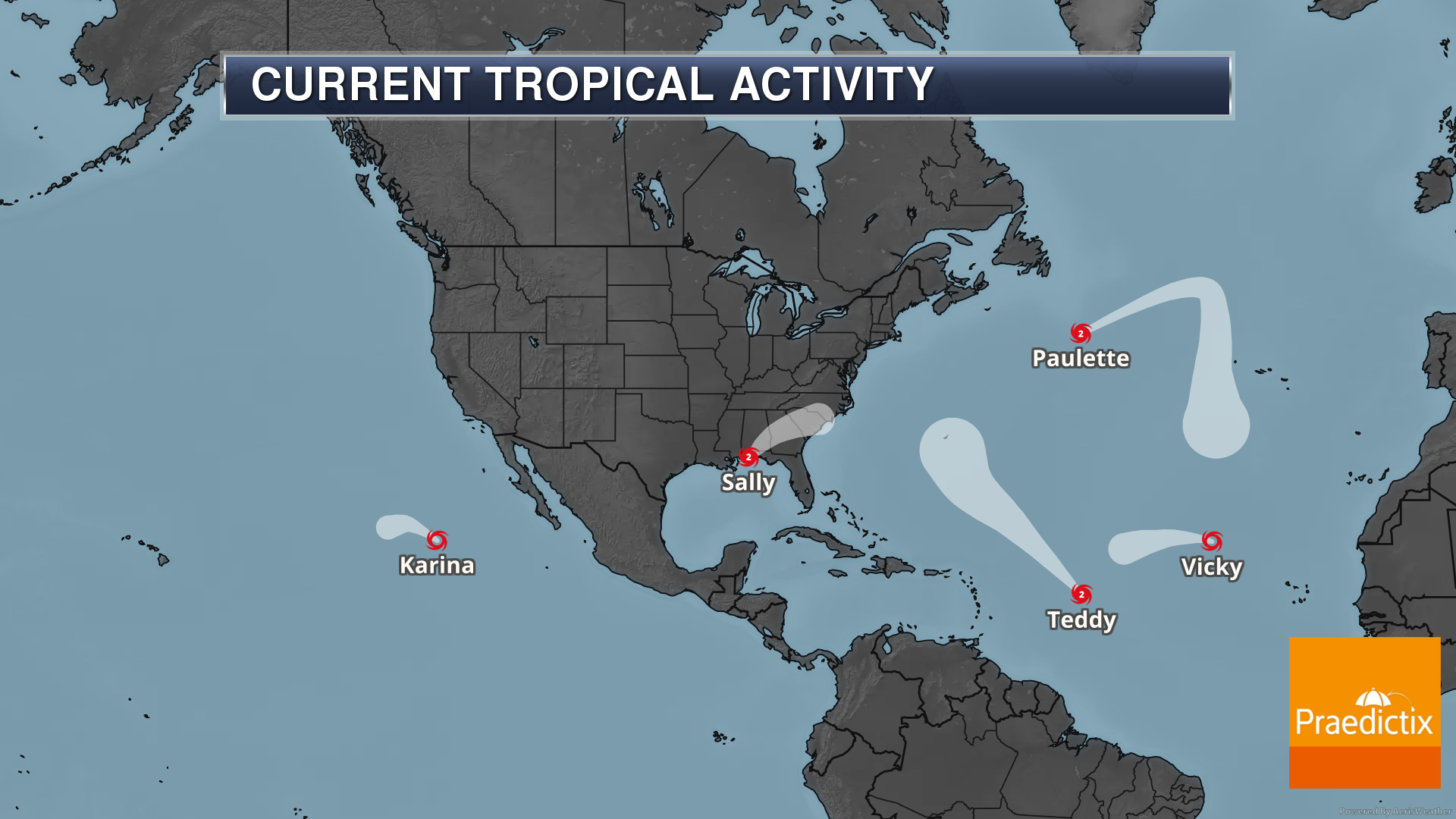

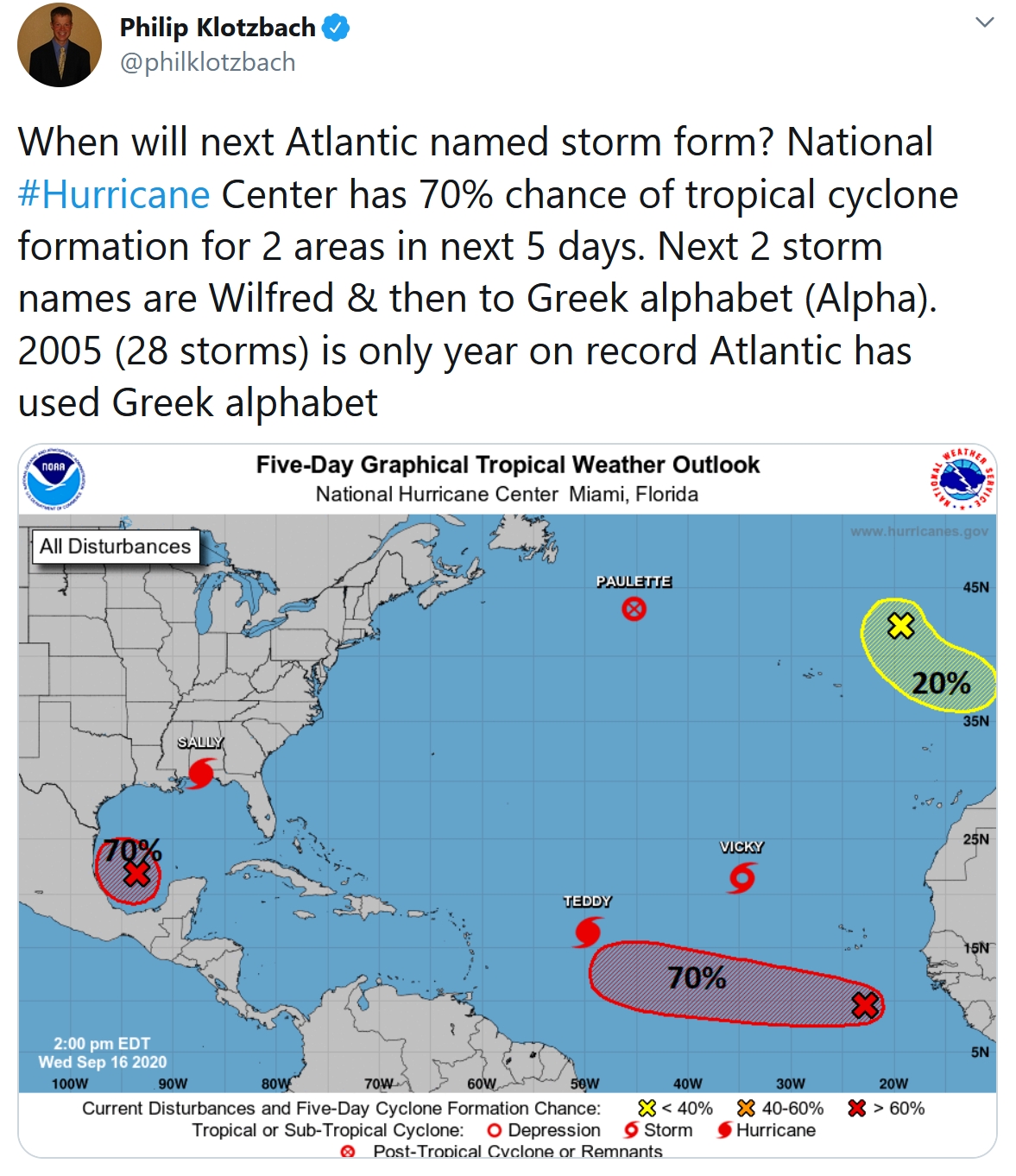
Other Tropical Activity. We are also watching the following systems in the Atlantic:
- Hurricane Paulette: Paulette is still a strong system out in the Atlantic and is expected to become post-tropical later today. While it is currently a fish storm, this system is producing waves estimated at 51 feet near the center according to the Ocean Prediction Center. This system could approach the Azores late this week/early this weekend.
- Hurricane Teddy: Teddy quickly strengthened overnight into a Category 2 hurricane and is expected to become a Category 4 hurricane with 130 mph winds later this week. Models have moved westward with the track of Teddy, and this does increase the threat for Bermuda late this weekend into early next week.
- Tropical Storm Vicky: Vicky is expected to weaken over the next few days and does not pose a threat to land through the end of the week.
- We are also tracking a few areas of interest that could form into tropical systems. There is one in the Gulf of Mexico that is becoming a little better organized. A tropical depression could form over the southern Gulf of Mexico this weekend as the system meanders across the region (60% chance in the next five days). We are also watching an area of low pressure south-southeast of the Cabo Verde Islands which has a high (70%) chance of formation in the next five days.
Western Wildfires
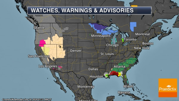
Fire Danger And Air Quality Concerns. A Fire Weather Warning (pink) remains in place today across portions of Oregon and northern California due to low humidity values and wind gusts to 35 mph which will allow wildfires to spread quicker. As we head into Thursday, numerous Fire Weather Watches (tan area) are in place from California and Oregon into the Great Basin due to stronger wind gusts and continued low humidity values and dry conditions. Air Quality Alerts (gray) remain in place across the western United States due to the smoke from the wildfires reducing air quality across the region, with Dense Smoke Advisories (khaki) in place as well due to the smoke.
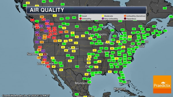
Hazardous Air Quality This Morning. We continue to track unhealthy to hazardous air quality across portions of the western United States due to all the wildfire smoke in the air.
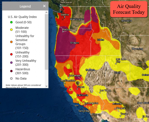
Air Quality Forecast. Unhealthy to hazardous air quality is expected to continue across the region today.
D.J. Kayser, Meteorologist, Praedictix
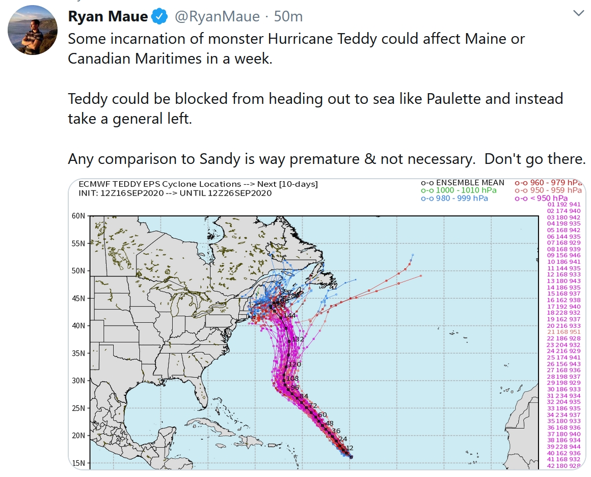
But Wait, There’s More! Hurricane Teddy is forecast to become a Category 4 weather-monster, come close to Bermuda, and then track northwestward, according to (often reliable) ECMWF guidance. It’s still way too early for specifics with a projected landfall in Maine or the Canadian Maritimes. But keep an eye on “Teddy”.
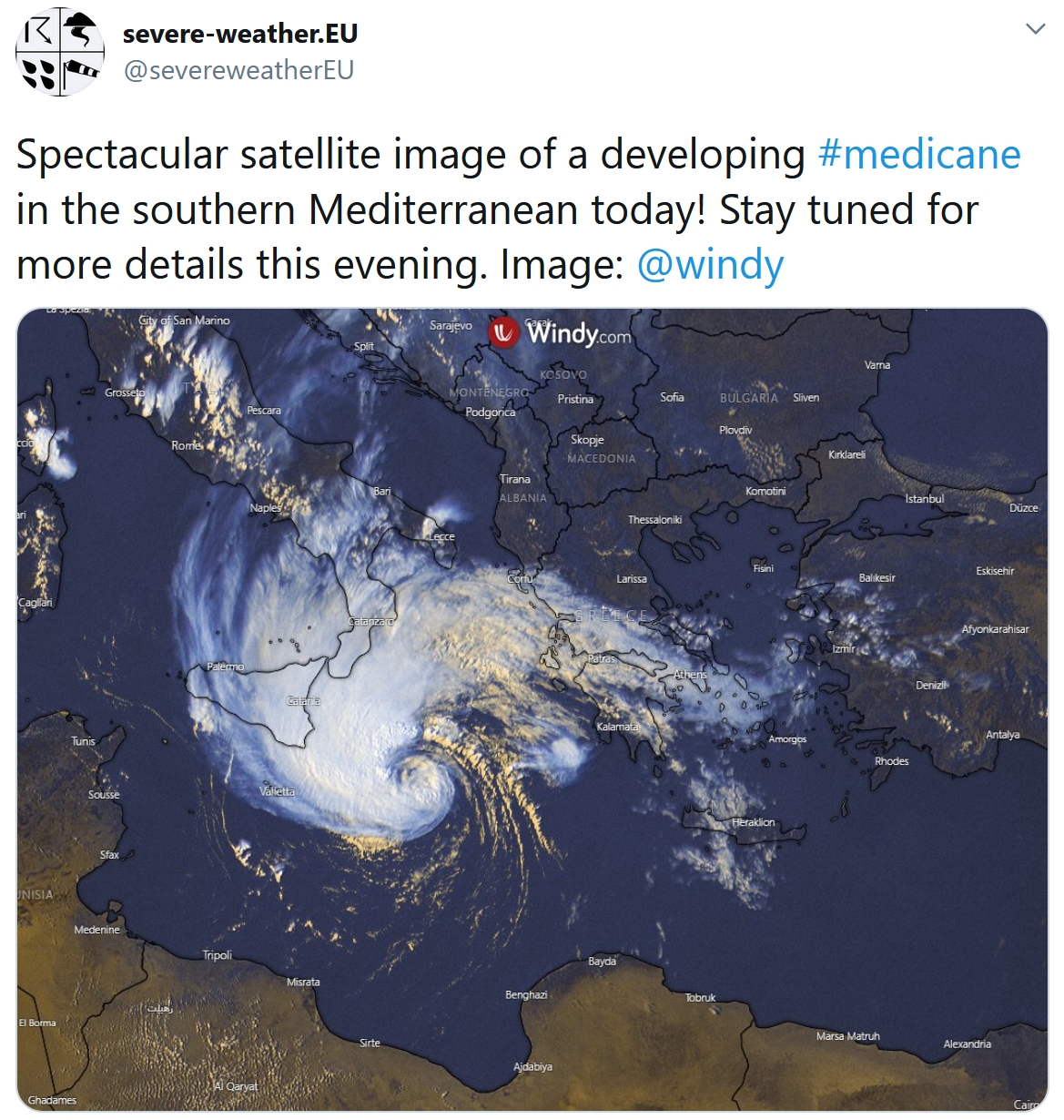
Go Away 2020. And now a “medicane” is threatening southern Greece with tropical-storm like conditions. Here’s more information from Greek Reporter: “…This sudden shift in the weather pattern is occurring just as experts are monitoring the possibility of a rare hurricane-like storm in the Mediterranean, dubbed a “Medicane.” This type of storm, composed of a cluster of thunderstorms, occurs once or twice a year, although it rarely impacts the eastern Mediterranean. Like hurricanes, Μedicanes feature strong winds that circle around a center-point, or eye. They are often accompanied by heavy rain. However, they are usually are a great deal weaker than true Atlantic-spawned hurricanes. These storms usually form in fall or early winter, when waters are relatively warm and provide energy to thunderstorms which are brewing above…”
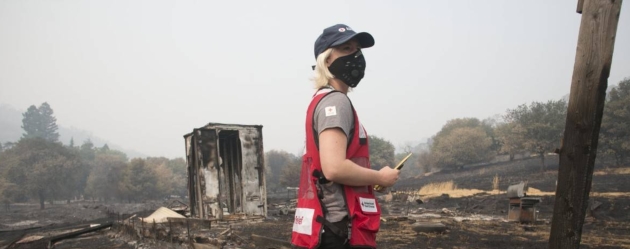
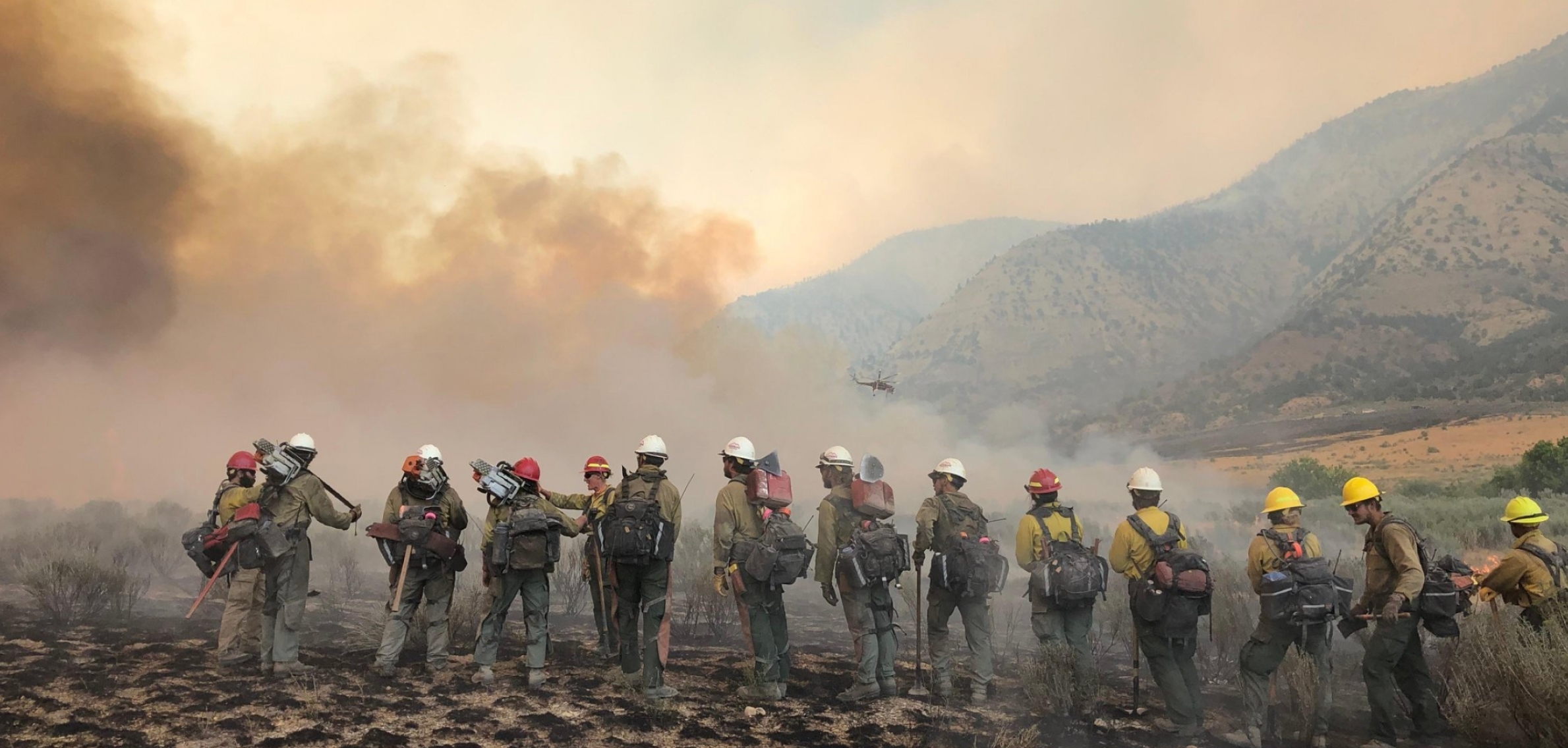
5 Ways to Help Victims of West Coast Fires. Mental Floss has some timely links: “Wildfires continue to ravage millions of acres across California, Oregon, and Washington, and strong winds forecasted in some of those regions could aggravate the blazes. To prevent future fires, we need to focus on combating climate change through policy reform and sustainable living. But for people directly affected by the fires, their current needs are much more urgent: food, shelter, and funds. Here are five organizations that can help you help victims...”
File image credit: American Red Cross.
NOAA: Hottest Summer on Record for North America. The symptoms of a warming world are probably not a coincidence, according to NOAA: “…According to scientists at NOAA’s National Centers for Environmental Information, the average global land and ocean surface temperature in August was 1.69 degrees F (0.94 of a degree C) above the 20th-century average of 60.1 degrees F (15.6 degrees C), making it the second-hottest August in the 141-year record, behind August 2016. The Northern Hemisphere had its hottest August on record with a temperature departure from average of 2.14 degrees F (1.19 degrees C), besting the previous record set in August 2016. Globally, the 10 warmest Augusts have all occurred since 1998 — with the five warmest occurring since 2015...”
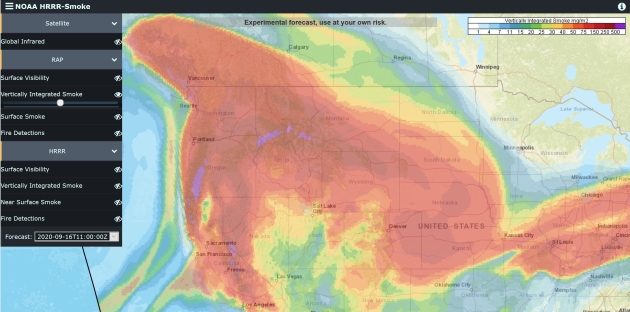
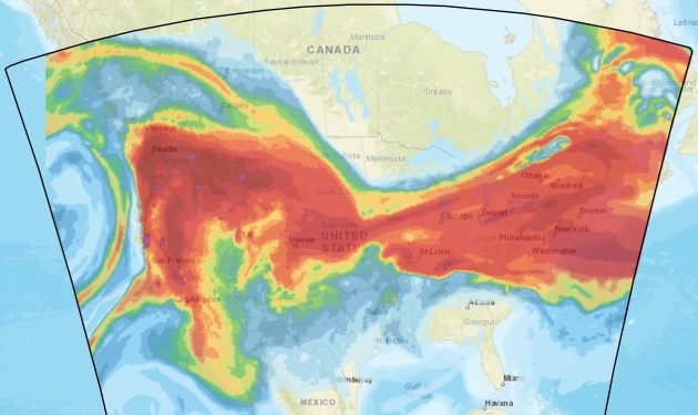
Tracking Smoke. NOAA has an online tool that pinpoints fire locations and smoke. Yesterday’s orange sun was a direct result of the massive amount of smoke being thrown off by western fires.
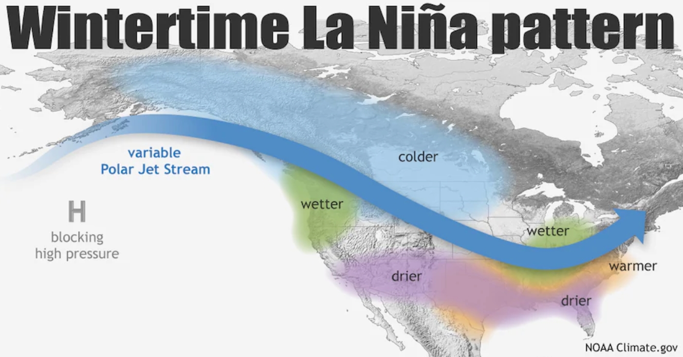
NOAA Declares La Nina Watch. Every La Nina and El Nino cycle is different, but based on a cooling trend in the Pacific Ocean the odds of an (easy/mild) winter for Minnesota and northern tier states has dropped a few notches. Here’s an explainer from Capital Weather Gang: “…NOAA forecasters have stated there is a 75 percent chance that La Niña will stick around for the entirety of winter. Generally speaking, La Niña typically increases the odds of above-average snowfall in the Pacific Northwest, northern Plains, Great Lakes region and northern New England. However, every La Niña is different, and other weather patterns can overwhelm its effects…”
Map credit: NOAA’s Climate.gov.
Wildfires During Pandemic Intensify Economic Pain in West. Associated Press has perspective: “…The fires are unlikely to make much of a dent in the overall $20 trillion U.S. economy. The financial fallout will be measured in the low billions of dollars, not in hundreds of billions or trillions. To make a nationwide impact, Kamins said, it would take something like Hurricane Katrina in 2005, which disrupted oil supplies. But the economic pain will be intense in areas decimated by fire, especially poor towns in rural Oregon and California, piling on at a time when many businesses have already succumbed to the pandemic-induced recession. U.S. economic activity collapsed at a record 31.7% annual pace from April through June...”
File image: NOAA.
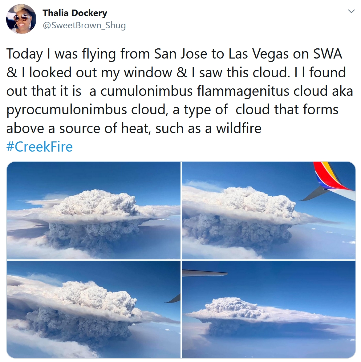
California’s Wildfire Smoke Plumes are Unlike Anything Previously Seen. Capital Weather Gang points out some of the unique (and vaguely terrifying) meteorological observations of this new breed of wildfire: “…The Creek Fire, which has burned nearly 200,000 acres in the Sierra Nevada mountains, was only 6 percent contained on Friday. On Sept. 5, a day after it was first ignited, its smoke plume soared to 55,000 feet. That’s taller than many of the tornadic thunderstorms that roll across Oklahoma and Kansas each spring. Such clouds are both indicators of and contributors to extreme fire behavior, such as rapid fire spread and the formation of fire vortices including tornadoes, along with other dynamics that are hazardous to firefighters and can imperil communities...”
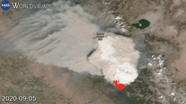
Evolution of a Pyrocumulonimbus Cloud. NASA has a great explainer; here’s an excerpt: “…The huge, dense cloud created on Sep. 05 and seen in the Suomi NPP image was a pyrocumulonimbus cloud (pyroCb) and the resulting smoke plume that grew upward was spotted and confirmed on Sep. 06, 2020. A pyrocumulonimbus cloud is also called a cumulonimbus flammagenitus. The origins of the latter word are from the Latin meaning “flame” and “created from.” This perfectly describes a cloud that is caused by a natural source of heat such as a wildfire or volcano. Rising warm air from the fire can carry water vapor up into the atmosphere causing clouds. Any type of convective cloud can be created. In this case, the cumulonimbus, or thunderhead cloud, was created. Precipitation and lightning can also occur with these types of clouds creating a risk that the fire will expand due to increased wind from precipitation downdraft or by creating new fires due to lightning strikes...”
Image credit: “This series of GIF images shows the development of the Creek fire from Sep 5 through Sep 7, 2020.” Credits: NASA Worldview
NOAA’s Former Satellite Now Providing Weather Data to the U.S. Military. SpaceNews explains whatever happened to GOES-13: “The U.S. Space Force announced that a geostationary weather satellite previously owned by the National Oceanic and Atmospheric Administration is now in service for the military providing coverage over the Indian Ocean. A satellite that NOAA first launched in 2006 and retired in 2018 has been repurposed as the Electro-Optical Infrared Weather System – Geostationary, or EWS-G1. The Space Delta 2 at Peterson-Schriever Garrison, Colorado, declared the satellite operational on Sept. 1. NOAA is operating EWS-G1 for the military collecting weather imagery over the Indian Ocean region in support of U.S. Central Command…”

Taco Bell is making its own wine. It’s 2020, why not. CNN.com reports: “Jalapeño Noir is designed to pair with its Toasted Cheesy Chalupa. There’s tons of cheese on Taco Bell’s menu, so a wine to pair with it is a natural next step. The tantalizing combination is only available for a limited time in Canada to celebrate the launch of the menu item…. Taco Bell Canada said in a release the duo is “irresistible,” adding that “the rich taste and crunchy texture of the beloved Toasted Cheesy Chalupa complements notes of wild strawberry, cherry and beetroot in this silky limited-edition red wine…”
Image credit here.

These are America’s 20 Worst Cities to Drive In. No kidding. Mental Floss makes an argument for public transportation; here’s an excerpt: “...For their report on the worst cities for drivers in 2020, the personal finance website compared 100 of the biggest cities in the country across 31 different metrics. The criteria they looked at included average gas prices, annual hours spent in traffic per commuter, and auto-repair shops per capita. Oakland, California, ranked top on the list of worst, largely thanks to the high cost of car ownership and maintenance rates in the Bay Area. It was followed by Philadelphia, which has some of the worst traffic and driving infrastructure of any U.S. city. San Francisco, Detroit, and New York City rounded out the bottom five...”
71 F. high in the Twin Cities on Wednesday.
72 F. average high on September 16.
87 F. high on September 16, 2019.
September 17, 1955: A late-season tornado hits Koochiching County. Most damage is confined to trees.
September 17, 1911: Pipestone is hit with baseball-sized hail that smashes numerous windows at the Calumet Hotel and high school. The local observer measures hail three inches deep. People get their photos taken in automobiles surrounded by the icy white ground.
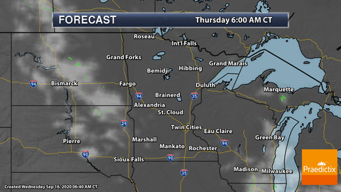
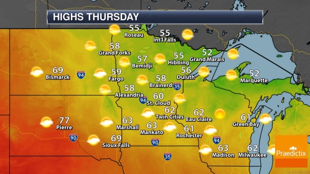
THURSDAY: Partly sunny and cool. Winds: NE 3-8. High: 62
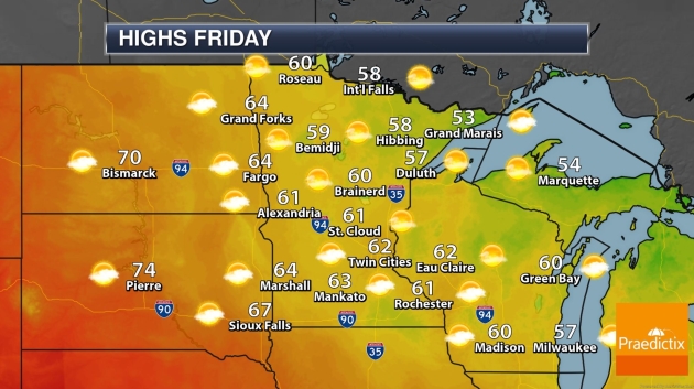
FRIDAY: Intervals of sun, comfortable. Winds: SE 7-12. Wake-up: 45. High: 63
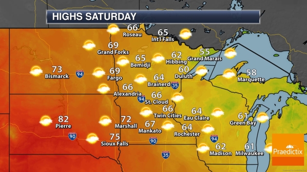
SATURDAY: Clouds increase, breezy. Winds: SE 10-15. Wake-up: 47. High: 68
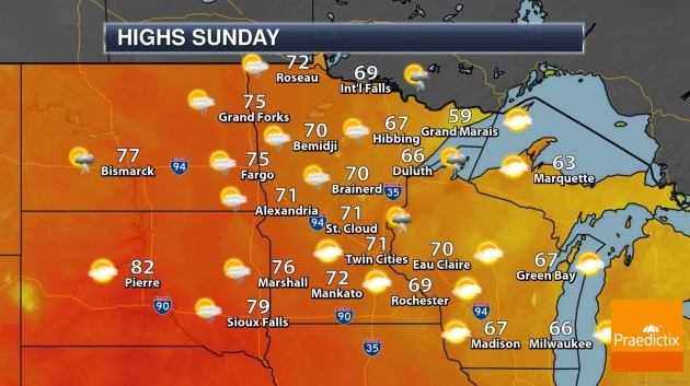
SUNDAY: Peeks of sun, a bit milder. Winds: S 10-20. Wake-up: 53. High: 72
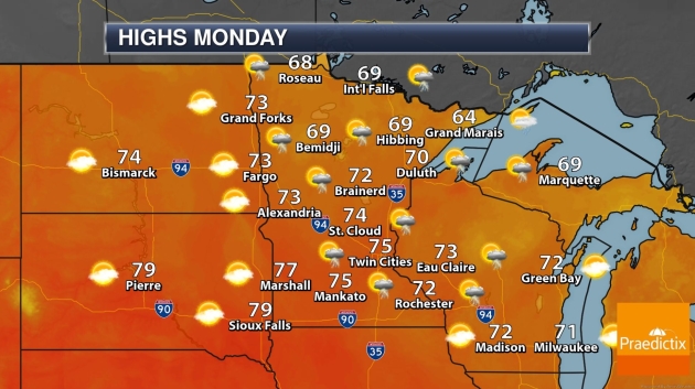
MONDAY: Showers and a few T-storms. Winds: S 10-20. Wake-up: 56. High: 69
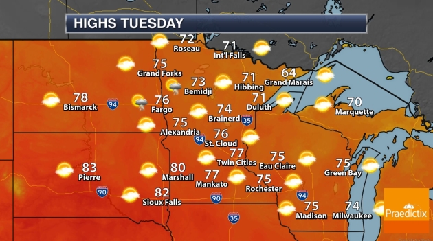
TUESDAY: Warm sunshine, very pleasant. Winds: SE 7-12. Wake-up: 59. High: 79
WEDNESDAY: Warm sunshine, summer’s not over yet. Winds: S 5-10. Wake-up: 60. High: 81
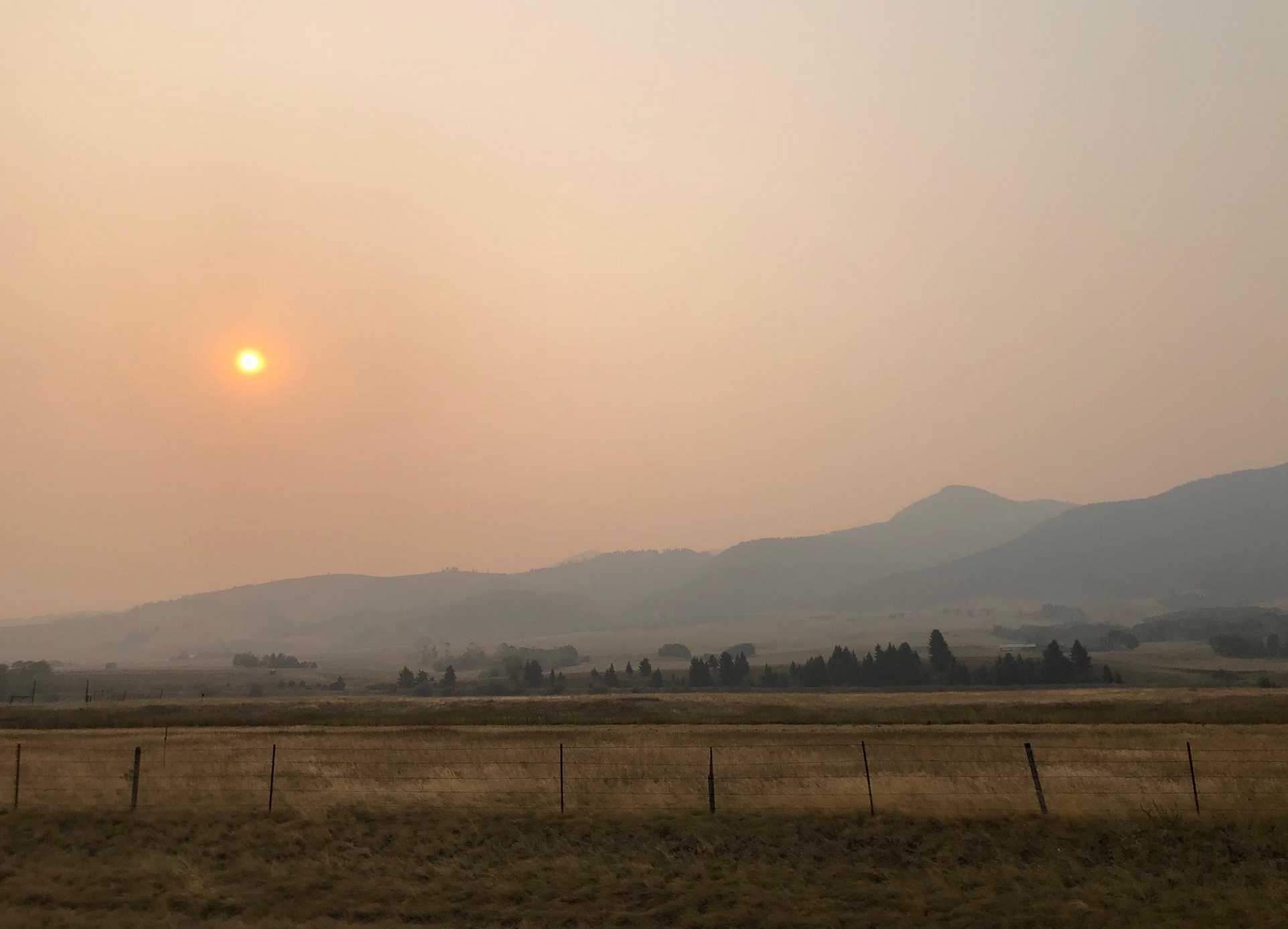
Photo from Bozeman, Montana courtesy of Praedictix meteorologist Susie Martin.
Climate Stories…
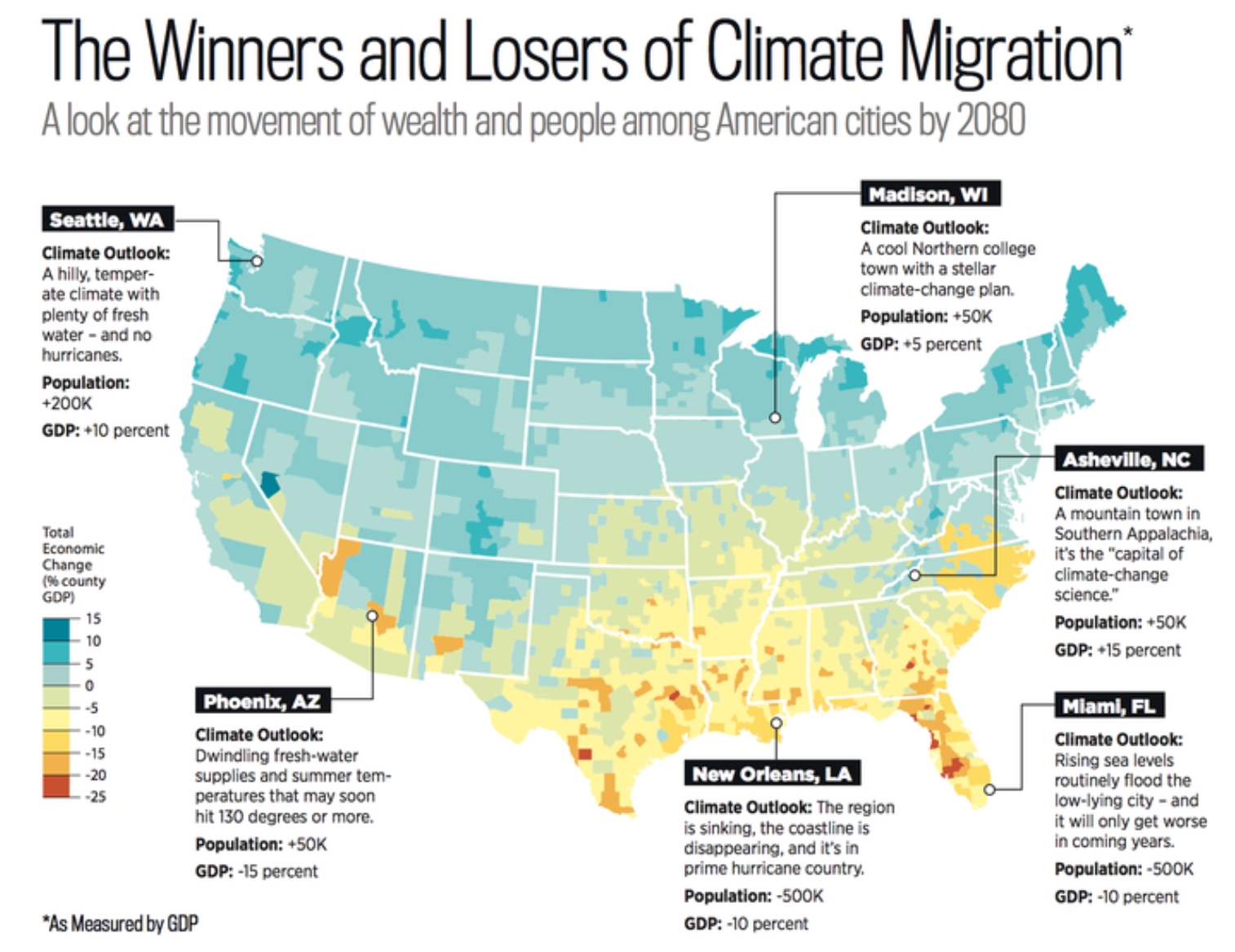
How Climate Migration Will Reshape America. The New York Times details the trends and predictions as more Americans try to get out of the way of some of the most extreme weather phenomena: “…In all, Hauer projects that 13 million Americans will be forced to move away from submerged coastlines. Add to that the people contending with wildfires and other risks, and the number of Americans who might move — though difficult to predict precisely — could easily be tens of millions larger. Even 13 million climate migrants, though, would rank as the largest migration in North American history. The Great Migration — of six million Black Americans out of the South from 1916 to 1970 — transformed almost everything we know about America, from the fate of its labor movement to the shape of its cities to the sound of its music. What would it look like when twice that many people moved? What might change?...”
Map credit: Rolling Stone.

Hurricane Sally Is a Slow-Moving Threat. Climate Change Might Be Why. A story at The New York Times (paywall) connects the dots: “…Climate change has made hurricanes wetter and slower, scientists have found. Recent research suggests that global warming — specifically in the Arctic, which is warming much more rapidly than other regions — is playing a role in weakening atmospheric circulation and thus potentially affecting hurricane speed. A 2018 study found that since the middle of the 20th century, translation speeds of all hurricanes and tropical storms had decreased by about 10 percent. Another study that year that focused on Atlantic hurricanes found that the average speed of storms near the North American coast had slowed by more than 15 percent…”
September 15, 2020 visible image credit: NOAA and AerisWeather.
Hurricane Sally’s Slow Movement – a Link to Climate Change? Here’s an excerpt from CNBC.com: “…The pace of tropical storms making landfall has slowed during the last several decades. The lingering creates worse rainfall and flooding. North Atlantic hurricanes specifically have been moving slower and stalling more frequently over the past even decades, according to research by NASA and the National Oceanic and Atmospheric Administration. Other research suggests that warming in the Arctic has weakened atmospheric circulation, which is likely affecting hurricane speed by causing a slowing of the jet stream. “Our own work suggests that climate change is favoring precisely such jet stream behavior,” said Michael E. Mann, a climate scientist at Penn State and an author of the report...”

Climate Crisis: 11,000 Scientists Warn of “Untold Suffering”. Sadly, many of those stories of suffering are already being told, this week along the Gulf Coast and the western U.S. Here’s a clip from The Guardian: “The world’s people face “untold suffering due to the climate crisis” unless there are major transformations to global society, according to a stark warning from more than 11,000 scientists. “We declare clearly and unequivocally that planet Earth is facing a climate emergency,” it states. “To secure a sustainable future, we must change how we live. [This] entails major transformations in the ways our global society functions and interacts with natural ecosystems.” There is no time to lose, the scientists say: “The climate crisis has arrived and is accelerating faster than most scientists expected. It is more severe than anticipated, threatening natural ecosystems and the fate of humanity…”
File photo credit: “A man uses a garden hose to try to save his home from wildfire in Granada Hills, California, on 11 October 2019.” Photograph: Michael Owen Baker/AP.

Scientific American Endores Joe Biden. I haven’t seen this before. Scientific American explains: “Scientific American has never endorsed a presidential candidate in its 175-year history. This year we are compelled to do so. We do not do this lightly. The evidence and the science show that Donald Trump has badly damaged the U.S. and its people—because he rejects evidence and science. The most devastating example is his dishonest and inept response to the COVID-19 pandemic, which cost more than 190,000 Americans their lives by the middle of September. He has also attacked environmental protections, medical care, and the researchers and public science agencies that help this country prepare for its greatest challenges. That is why we urge you to vote for Joe Biden, who is offering fact-based plans to protect our health, our economy and the environment…”
Illustration credit: Ross MacDonald.

Conservative Media and Trump Dismiss Climate Change as Cause of Fires. The New York Times (paywall) has perspective on right wing media amplifying climate denier talking points: “Rush Limbaugh told millions of his radio listeners to set aside any suggestion that climate change was the culprit for the frightening spate of wildfires ravaging California and the Pacific Northwest. “Man-made global warming is not a scientific certainty; it cannot be proven, nor has it ever been,” Mr. Limbaugh declared on his Friday show, disregarding the mountains of empirical evidence to the contrary. He then pivoted to a popular right-wing talking point: that policies meant to curtail climate change are, in fact, an assault on freedom. “Environmentalist wackos” — Mr. Limbaugh’s phrase — “want man to be responsible for it because they want to control your behavior,” the conservative host said on the show…”
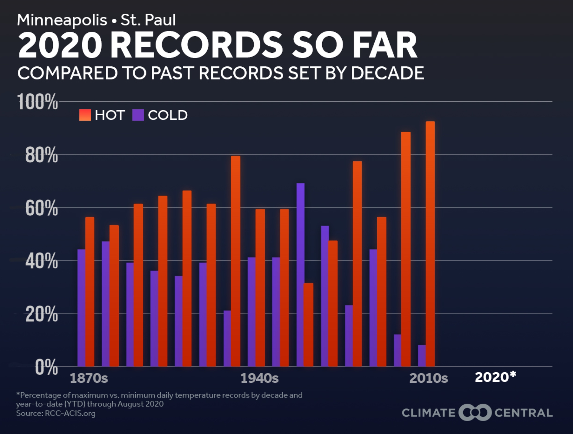
Tracking Record High – Record Low Trends. More perspective via Climate Central: “…From January through August 2020, in a separate analysis of 231 cities, 73% (170) had more record temperature highs than lows, and 50% of those cities (86 of 170) only broke record highs. A notable example is Miami, Fla. that experienced 22 daily record highs and 0 lows. This imbalance of record highs to lows is a hallmark of climate change as the global average temperature increases...”
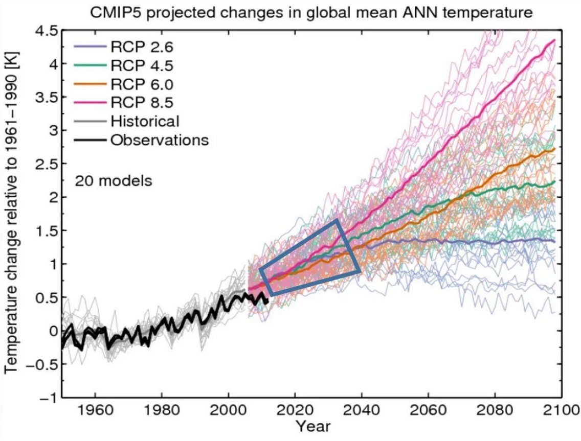
The Trump Team Has a Plan to Not Fight Climate Change. I’m still waiting for the president to unveil his climate action plan, and will publish details and links as soon as it’s made available. Here’s an excerpt from a WIRED.com post (paywall): “…Model-bashing has been a favorite pastime among those who deny that humans are the primary drivers of climate change. This makes perfect sense, since it’s the models that dictate action: They show what might happen if we continue down our current path and hint at how we might avoid it. If the models can’t be trusted, or if their scope is limited, then the future is unknowable; and if the future is unknowable, then what’s the case for regulation? That’s why the most heavily polluting industries have been incentivized to focus on climate models’ flaws, in much the way that commercial interests have tried to shower doubt on research into the long-term health effects of asbestos, smog, and cigarettes (among many other things). Indeed, a network of conservative think tanks, including the Heritage Foundation and the Heartland Institute, have consistently pushed the notion that climate models are defective, which has in turn become a central talking point at the White House...”
Image credit: “The “spaghetti chart” of climate-change scenarios.” USGS.
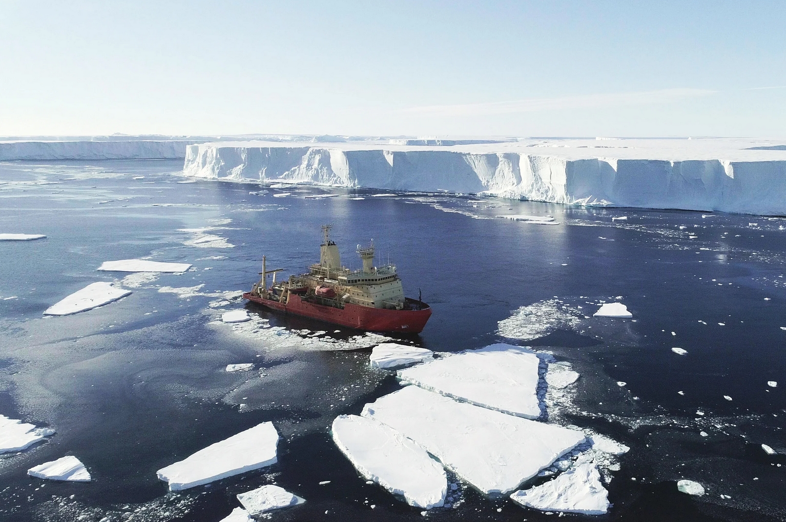
Antarctic Glaciers are Growing Unstable Above and Below Water. Here’s an excerpt from a WIRED.com article: “…Scientists say Thwaites and the other glaciers are not likely to collapse in the next century; they are simply too big to fail right now. At the same time, they are seeing troubling signs of increased melting that can still cause a slow rise in sea levels around the globe. One of the big questions is the speed of the melting, and whether it will reach some kind of tipping point where it will be unable to be reversed if society is able to contain carbon emissions and somehow slow climate change. “The ice shelf is getting weaker,” says Stef Lhermitte, an assistant professor of geoscience and remote sensing at the Technical University of Delft in the Netherlands. “The ice shelf slows down the traffic behind. At the moment you lose the ice shelf, the glaciers are free to flow and discharge their ice into the ocean…”
Photo credit: Alex Mazur/International Thwaites Glacier Collaboration.
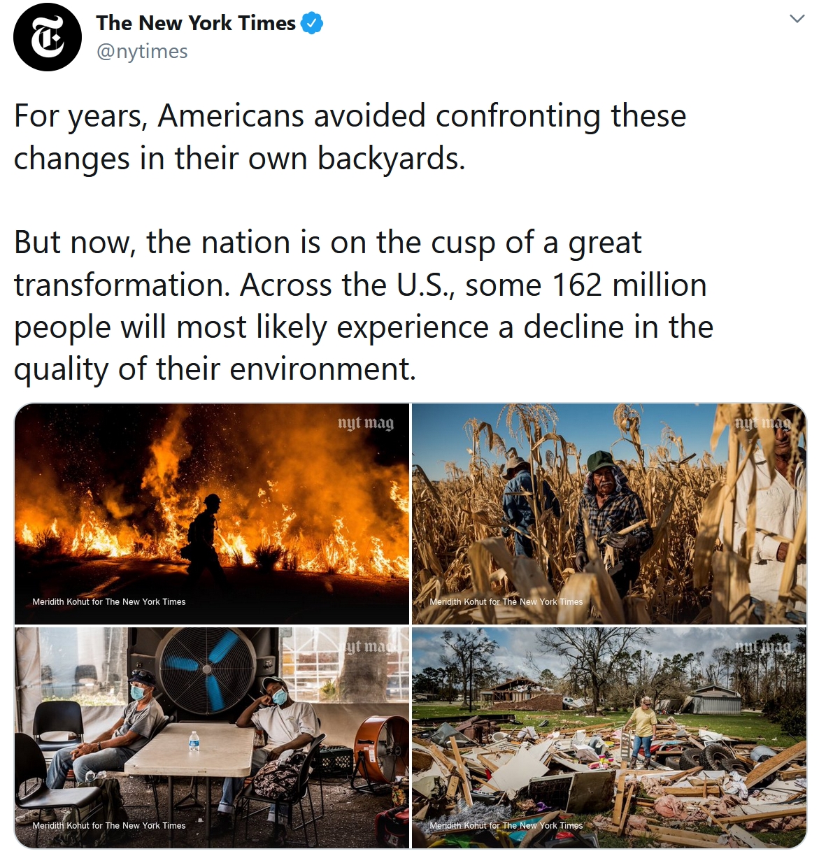
Climate Change Will Force a New American Migration. Note to self – it’s already happening. ProPublica examines the threat and subsequent trends in where Americans want to live: “…What I found was a nation on the cusp of a great transformation. Across the United States, some 162 million people — nearly 1 in 2 — will most likely experience a decline in the quality of their environment, namely more heat and less water. For 93 million of them, the changes could be particularly severe, and by 2070, our analysis suggests, if carbon emissions rise at extreme levels, at least 4 million Americans could find themselves living at the fringe, in places decidedly outside the ideal niche for human life. The cost of resisting the new climate reality is mounting. Florida officials have already acknowledged that defending some roadways against the sea will be unaffordable. And the nation’s federal flood-insurance program is for the first time requiring that some of its payouts be used to retreat from climate threats across the country. It will soon prove too expensive to maintain the status quo…”

Will Extreme Weather Keep Getting Worse? Scientists Say Yes. Here’s the intro to a post at Weather.com: “One by one, climate and disaster records and milestones have been shattered in 2020. The stories of the extremes make daily headlines: Nine cities see their earliest snowfall ever. A South Dakota River was in flood stage for 17 months. The last decade was the hottest ever recorded on Earth. A brutal California heat wave had off-the-charts temperatures. Historic wildfires burn across the western United States. Things can only go up from here, right? That’s not what the experts say. Scientists and climate experts resoundingly agree that we’re likely to see more years like 2020, with more intense, destructive and deadly weather events…”
Image credit: NOAA CPO.
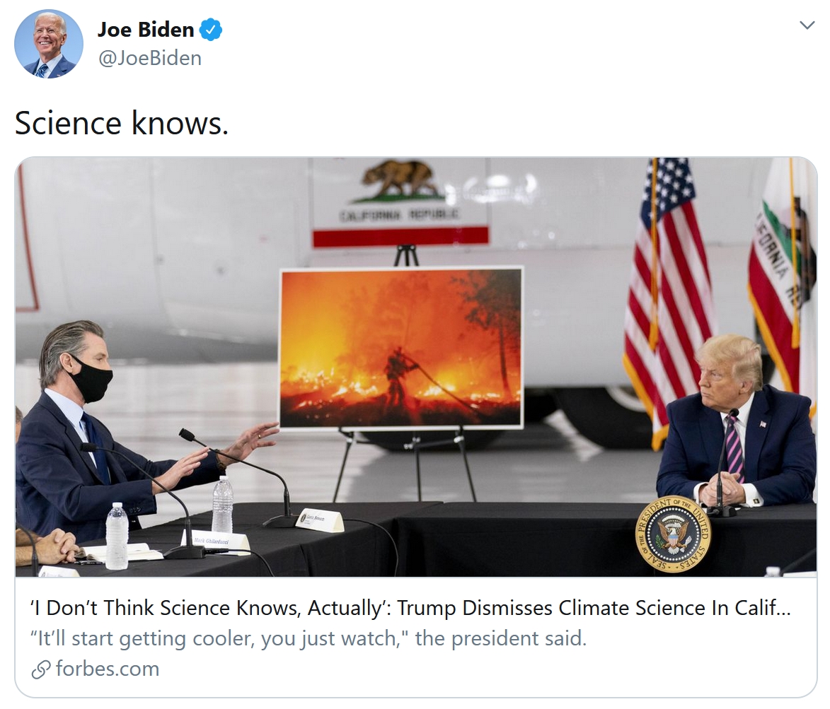
What Happened During Trump’s (California) Visit? Here’s an excerpt from The New York Times (paywall): “…On Monday, President Trump met with Gov. Gavin Newsom and a group of California officials in McClellan Park outside Sacramento. The California officials wore masks. The president did not. “It’ll start getting cooler,” Mr. Trump said. “You just watch.” Wade Crowfoot, the secretary of the California Natural Resources Agency, told Mr. Trump that he hoped the weather would, indeed, cool. “I wish science agreed with you,” Mr. Crowfoot said. “I don’t think science knows, actually,” President Trump responded. Climate change is not a matter of debate among scientists…”
In Smoky Skies, Clarity on Climate Crisis. Here’s an excerpt of an Op-Ed from the Star Tribune Editorial Board: “…A California official brought up climate change, but Trump was uninterested. “It will start getting cooler,” he said. “You just watch. I don’t think science knows, actually.” Science does know, actually. The case for human-influenced climate change is well established. Trump’s dismissive attitude toward the science of climate change is no more based in reality than his minimizing (in public, anyway) of the deadliness of the coronavirus. Closer to the mark was Joe Biden, the Democratic challenger to Trump’s re-election bid, who also spoke about the fires Monday. In his own incendiary comments, he used the words “climate arsonist” in reference to the president. It’s reasonable to call Trump to account for his negligence toward the climate crisis. But “arsonist” sounds like the rhetoric of the rumor mongers who blame antifa operatives for setting some of the wildfires...”

Climate Change Denialist Given Top Role at Major U.S. Science Agency. By all means let’s sugarcoat what’s really happening right now. Science Magazine has the troubling news: “…The move marks an escalation within the Trump administration to undermine the agency’s ability to warn the public of climate risks, observers said. Legates has spent his career denying consensus climate science while elevating the work of fringe researchers and industry-funded scientists. He has claimed that addressing climate change would do more harm than good, and he has said pumping more carbon dioxide into the atmosphere would benefit humanity. When testifying before the House of Representatives Natural Resources Committee last year, Legates blamed natural variations for the unprecedented level of warming that scientists say is caused by the release of carbon dioxide from human activity. “Climate has always changed, and weather is always variable, due to complex, powerful natural forces,” Legates said. “No efforts to stabilize the climate can possibly be successful...”
Facebook and Google Announce Plans to Become Carbon Neutral. The Guardian reports: “Facebook and Google are becoming carbon neutral businesses, joining competitors Apple and Microsoft in committing to put no excess carbon into the atmosphere, both companies have independently announced. But the details of the two companies’ ambitions differs greatly. At Google, which first committed to going carbon neutral in 2007, the announcement sees the company declaring success in retroactively offsetting all carbon it has ever emitted, since its foundation in 1998. It has also committed to being powered exclusively by renewable energy by 2030. If that sounds familiar, it’s because it is: in 2017, Google became a “net-zero” company, buying renewable energy to match its energy usage, but was unable to fully commit to eliminating carbon-emitting generation entirely...”