
Monday’s National Weather Forecast

An area of low pressure moving through the Upper Midwest Monday along with a stationary front will bring periods of showers and storms from the Northern Plains (where a second area of low pressure will also be positioned) to the Great Lakes. Another trough of low pressure could spark showers and storms across the Central Plains. A stationary front in Canada could help bring some rain to portions of New England. Meanwhile, typical summertime storms will be possible across portions of Florida.


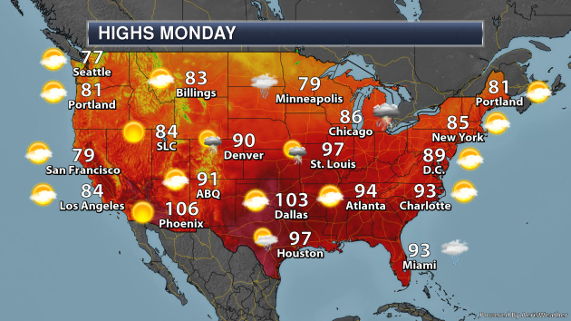
Summer heat will continue to bake parts of the southern United States Monday with highs in the 100s for areas like Oklahoma City, Dallas, and San Antonio. Heat index values will be higher when you factor in the humidity, even topping 110F in Little Rock, New Orleans, and Brownsville.


Some of the heaviest rain through Tuesday evening will be in the upper Midwest and Great Lakes where totals could top 2″ in some locations. Downpours could lead to rainfall amounts of 1-2″ across portions of Florida as well.
_______________________________________________
Twin tornadoes whip through northern Europe, hospitalizing at least 14 people
More from CNN: “At least 14 people were hospitalized after a tornado tore through southwestern Luxembourg Friday, damaging over 160 houses before progressing into eastern France. Another tornado also struck the city center of Amsterdam, the Dutch capital, the same day, gathering debris and whipping across a river. In Luxembourg, wind speeds reached 128 kilometers per hour (80 miles per hour), Agence France-Presse (AFP) reported. Two people sustained more serious injuries, the government said, and remained in hospital on Friday night.”
Hottest temperature ever recorded in Colorado under review
More from 9NEWS: “The thermometer spiked to 115 degrees at John Martin Reservoir on July 19, but in Bent County, where triple digits are normal, it slipped passed the media, the National Weather Service (NWS), and the Colorado Climate Center. “I didn’t have the siren go off in my office. ‘Beep, beep, beep, we have a new temperature record,'” said assistant state climatologist Becky Bolinger, joking about how there is now automatic alerts.”
Climate change and overfishing are increasing toxic mercury levels in fish, study says
More from CBS News: “Mercury levels in the seafood supply are on the rise, and climate change and overfishing are partially to blame, according to a new study. Scientists said mercury levels in the oceans have fallen since the late 1990s, but levels in popular fish such as tuna, salmon and swordfish are on the rise. According to a new study by Harvard University researchers in the journal Nature, some fish are adapting to overfishing of small herring and sardines by changing their diets to consume species with higher mercury levels. Based on 30 years of data, methylmercury concentrations in Atlantic cod increased by up to 23% between the 1970s and the 2000s. It links the increase to a diet change necessitated by overfishing.”
_______________________________________________
Thanks for checking in and have a great Monday! Don’t forget to follow me on Twitter (@dkayserwx) and like me on Facebook (Meteorologist D.J. Kayser)!
– D.J. Kayser
