
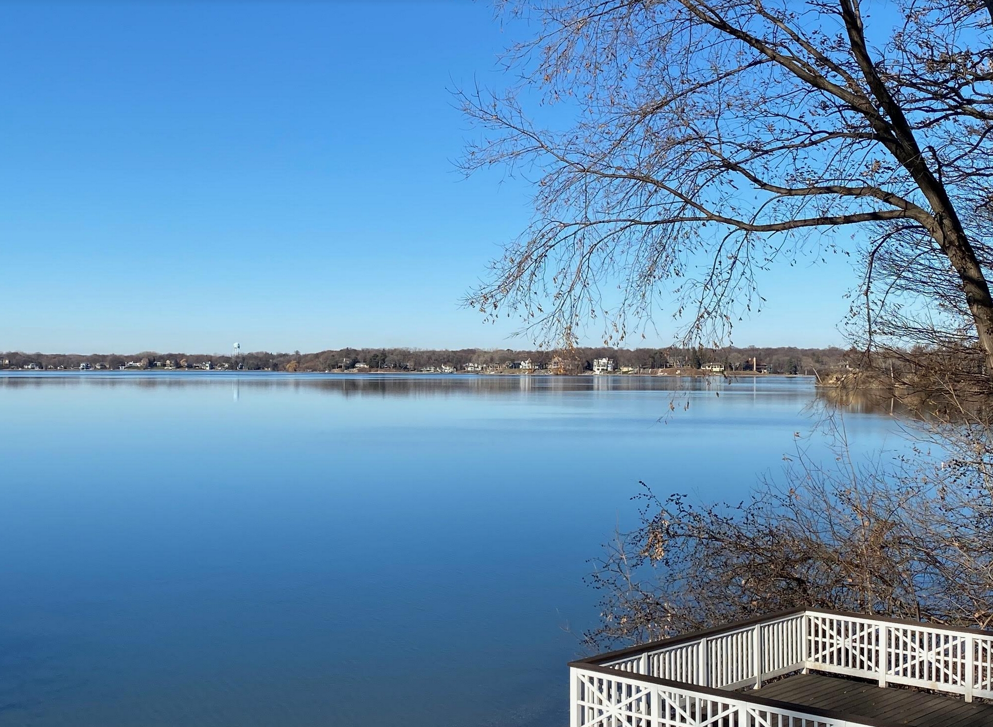
Blue Sky December Coping Skills
Coping skills are getting a stress-test this year. For me it’s a streaming-TV coccoon every evening and Frosted Mini Wheats for lunch. No judging. That, and an empty Doppler screen.
I have a strange, irrational urge to ski Oklahoma, because that’s where the accumulating snow is today. I’m tracking a persistent parade of big, sloppy storms across the south and eastern seaboard, with little chance of winter weather watches or warnings close to home anytime soon. There’s a high probability December will wind up milder than average, and a white Christmas may come down to the wire this year.
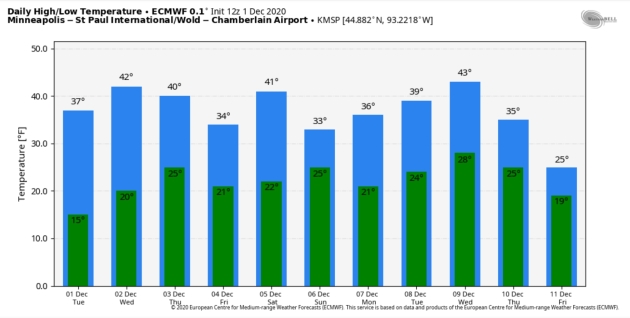
At least the sun is out (another coping skill) and blue sky rules into much of next week. ECMWF predicts 4 or 5 days at or above 40F (nearly 10F above average) through next Wednesday. Any cellophane-thin layer of ice that forms each night will melt by day. We may not have skatable, fishable ice until late December or early January.
At some point the other shoe (boot) will drop. It always does. Enjoy intermission.
Photo credit: Paul Douglas.

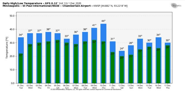
Supernaturally Quiet. A couple of (weak) cold frontal passages, but nothing that passes for a real “storm” into next week, according to a consensus of weather models. NOAA NDFD daytime high numbers (above) may be running a couple degrees too cool, with a built-in bias toward normal temperatures. I think we’ll see a few days at or just above 40F in the metro – not bad considering average highs now are close to 32F.
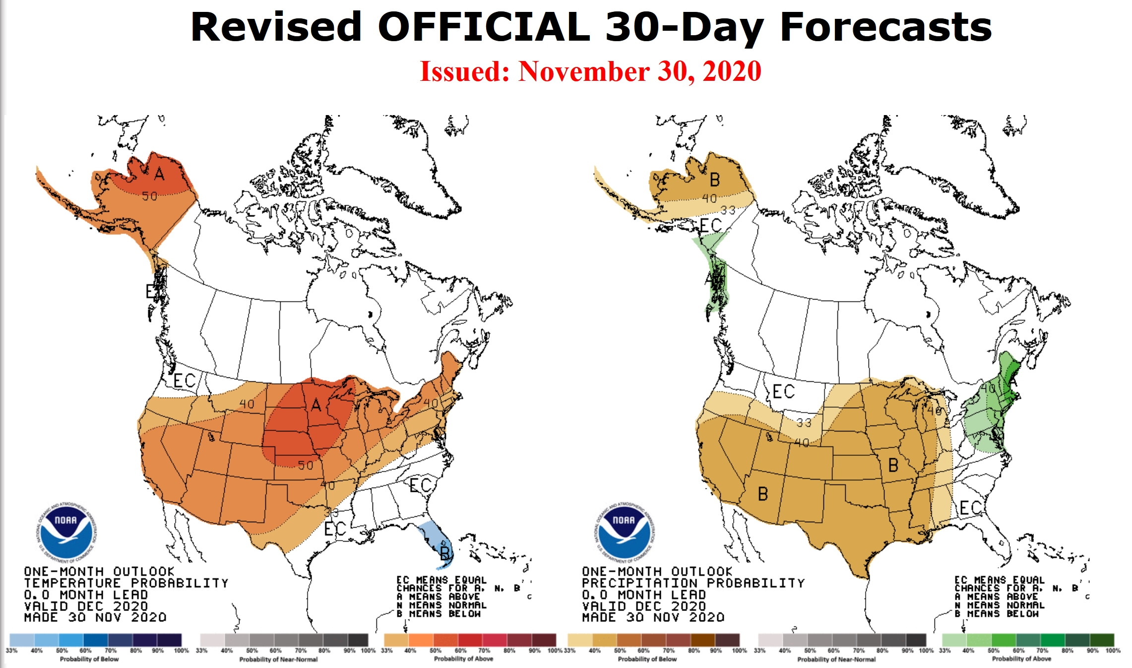
December Outlook: Climate Prediction Center. Here is the latest temperature and precipitation outlook from NOAA CPC. Looks pretty toasty.
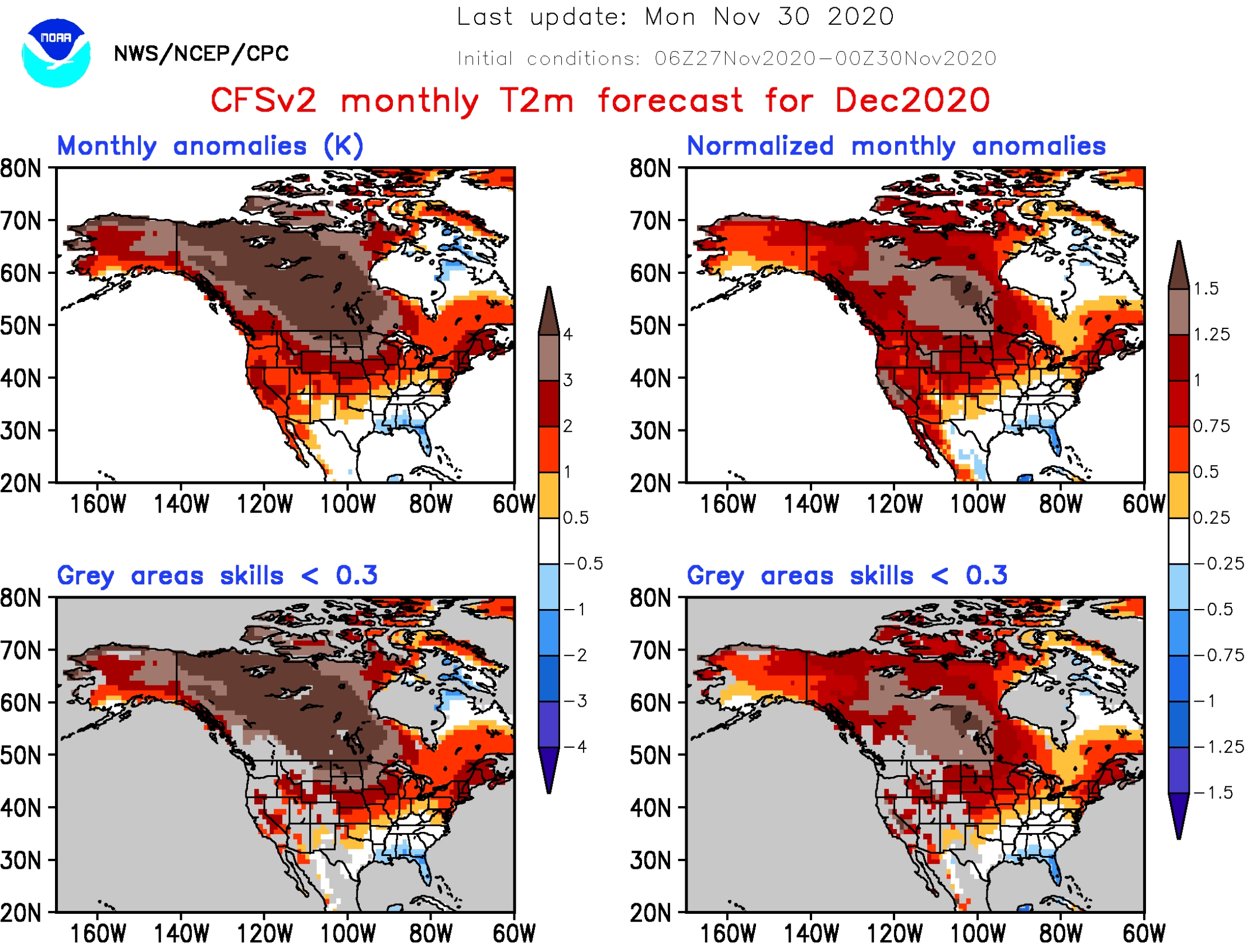
December Temperature Anomalies. 4-8F warmer than average this month? That’s what NOAA’s Climate Forecast System version 2 is (consistently) predicting for December across Minnesota, with eye-opening anomalies over 10F for much of Canada. To which I reply, what La Nina? Map credit: NOAA.

Operational Winter Storm Severity Index. With the exception of lake effect snow and some snow and icing over Kansas and northern Oklahoma, it looks fairly quiet across the USA. NOAA WPC is making WSSI operational – another step forward.

A Tornado-Proof Home? Don’t laugh, the trend may catch on in the heart of Tornado Alley. Here’s an excerpt of a design concept from 10design.com and FX Magazine: “…The goal of this research and initial concept is to shift the way people look at natural disasters, and to ultimately design entire towns around the concept of disaster resistance. The tornado proof house is intended to be a tornado and flood proof home for the American Midwest. A portion of the house is raised up and down out of harm’s way on a series of hydraulic arms. When a storm approaches, sensors activate the hydraulics and lower the house into the ground and the roof is sealed under water proof doors. By raising the house, it allows for daylight and cross ventilation, which are lacked in typical underground houses. The house is intended to save lives and remove the extremely expensive rebuilding efforts required after storms…”
Praedictix Briefing: Issued Tuesday, December 1st, 2020:
Eastern Great Lakes Snow
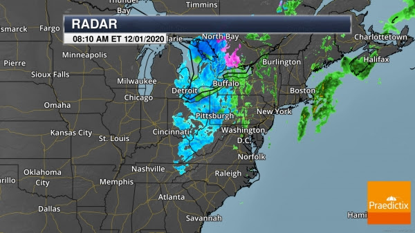
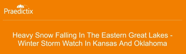
Heavy Snow In The Eastern Great Lakes. Heavy snow is falling this morning in portions of the eastern Great Lakes, particularly south of Lake Erie. So far, 8″ of snow has been reported in Chardon, OH, with 5.5″ in Boston Heights, OH.
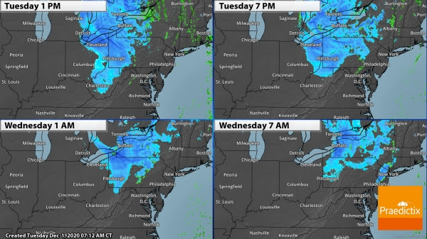
Snow Continues Today. Heavy snow will continue across portions of Ohio to eastern Pennsylvania and eastern New York state today. You can see the models showing some lake enhancement with heavier bands downwind of Lake Erie at times. Snow will continue, heavy at times, in Cleveland today, tapering off tonight. Snow showers will be possible today into Wednesday in Buffalo.
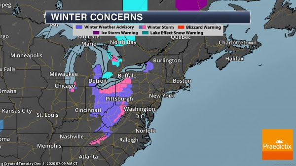
Winter Storm Alerts. Numerous Winter Storm Warnings and Winter Weather Advisories remain in place from the Appalachians to the eastern Great Lakes. This includes the following locations:
- Gatlinburg, TN: Winter Storm Warning though Noon Tuesday for an additional 1-2” of snow.
- Cleveland, OH: Winter Storm Warning through 10 AM Wednesday for total snow accumulations of 6-16” with winds to 35 mph.
- Charleston, WV: Winter Weather Advisory through 7 PM Tuesday for a total of 2-4” of snow.
- Columbus, OH: Winter Weather Advisory through Noon Tuesday for up to an additional inch of snow.
- Erie, PA: Winter Weather Advisory through 4 PM Wednesday for total snow accumulations of 3-7” with winds to 35 mph.
- Detroit, MI: Winter Weather Advisory through Noon Tuesday up to an additional 1-2” of snow.
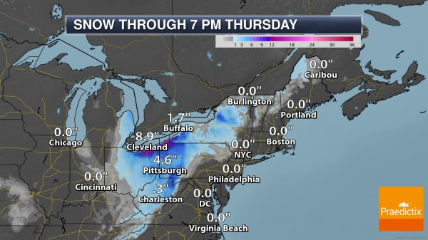
Additional Expected Snow. The heaviest additional snow is expected south of Lake Erie through Wednesday, particularly in the higher terrain east of Cleveland into northwestern Pennsylvania. In these areas, up to an additional 15” of snow could fall in some locations. The heaviest snow will fall today, with snow fading tonight into Wednesday across the region. In Cleveland, 3-9” of snow is expected to fall today, with up to an additional 2” of snow tonight.
Central Plains Snow
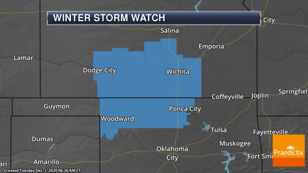
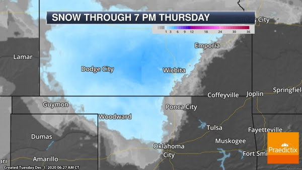
Winter Storm Watches In Kansas And Oklahoma. As an area of low pressure moves through the Central Plains Wednesday into early Thursday, rain across portions of Kansas and Oklahoma is expected to change over to some snow – potentially heavy in spots. In some areas, 2-5” of snow could fall depending on where heavy snow bands set up. Winter Storm Watches are in place from Dodge City to Wichita down to Ponca City and Woodward.
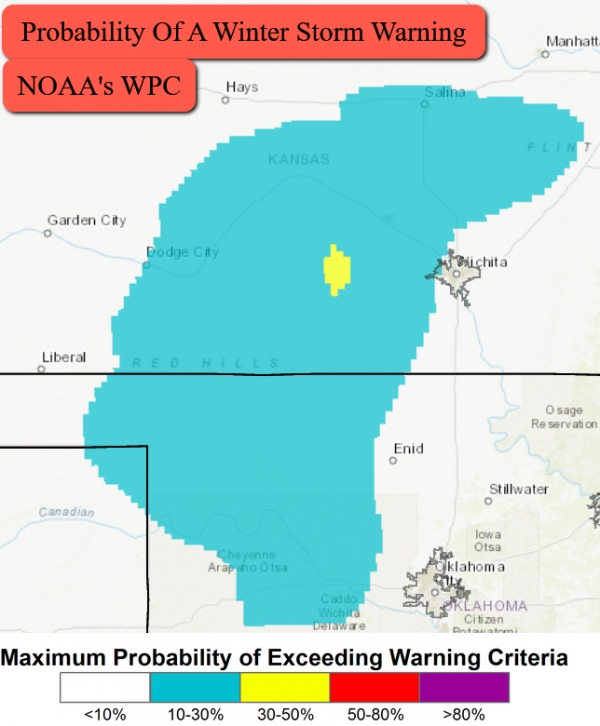
Potential For A Winter Storm Warning. I would expect refinement of the Winter Storm Watch into Warnings and Advisories over the next 24-36 hours, especially since some areas could see a rain/snow mix hang on into Wednesday Night before changing over to all snow. NOAA’s Weather Prediction Center has a new product called the Winter Storm Outlook, which uses their forecasts to help determine whether enough snow could fall for a Winter Storm Warning. While the odds of that occurring seem low as 4-6” of snow would need to fall in a 12-hour period across the region for a warning to be issued, this snow will still cause slippery road conditions and could impact the Wednesday evening and Thursday morning commutes.
D.J. Kayser, Meteorologist, Praedictix
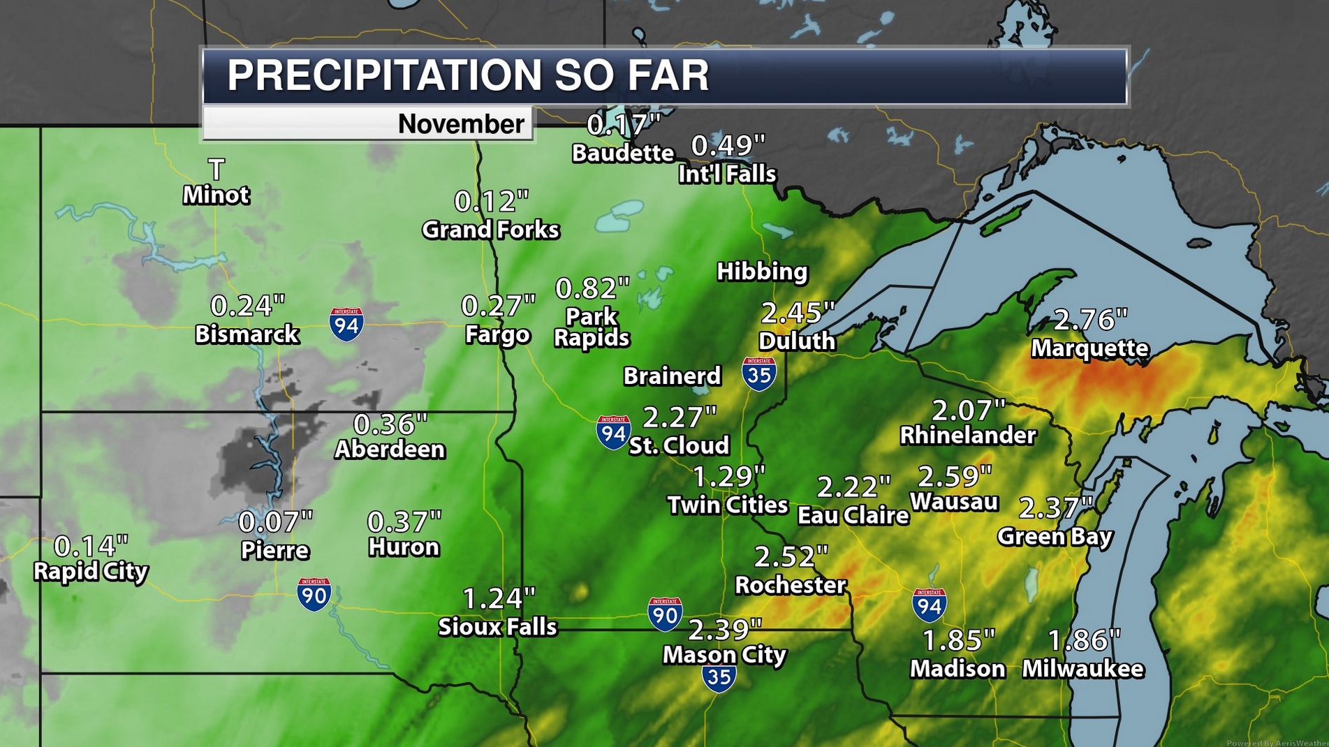
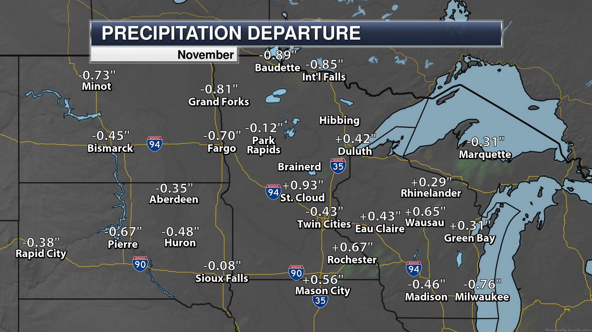
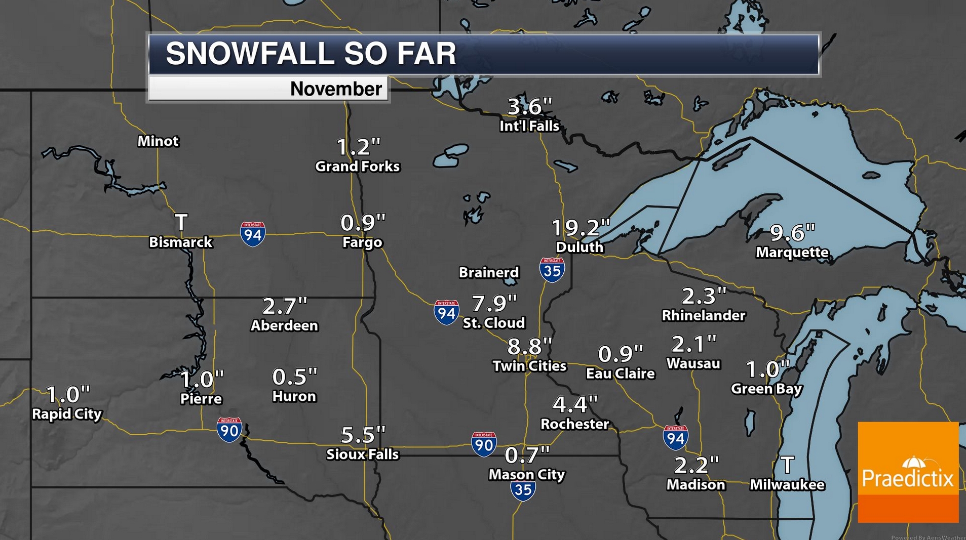
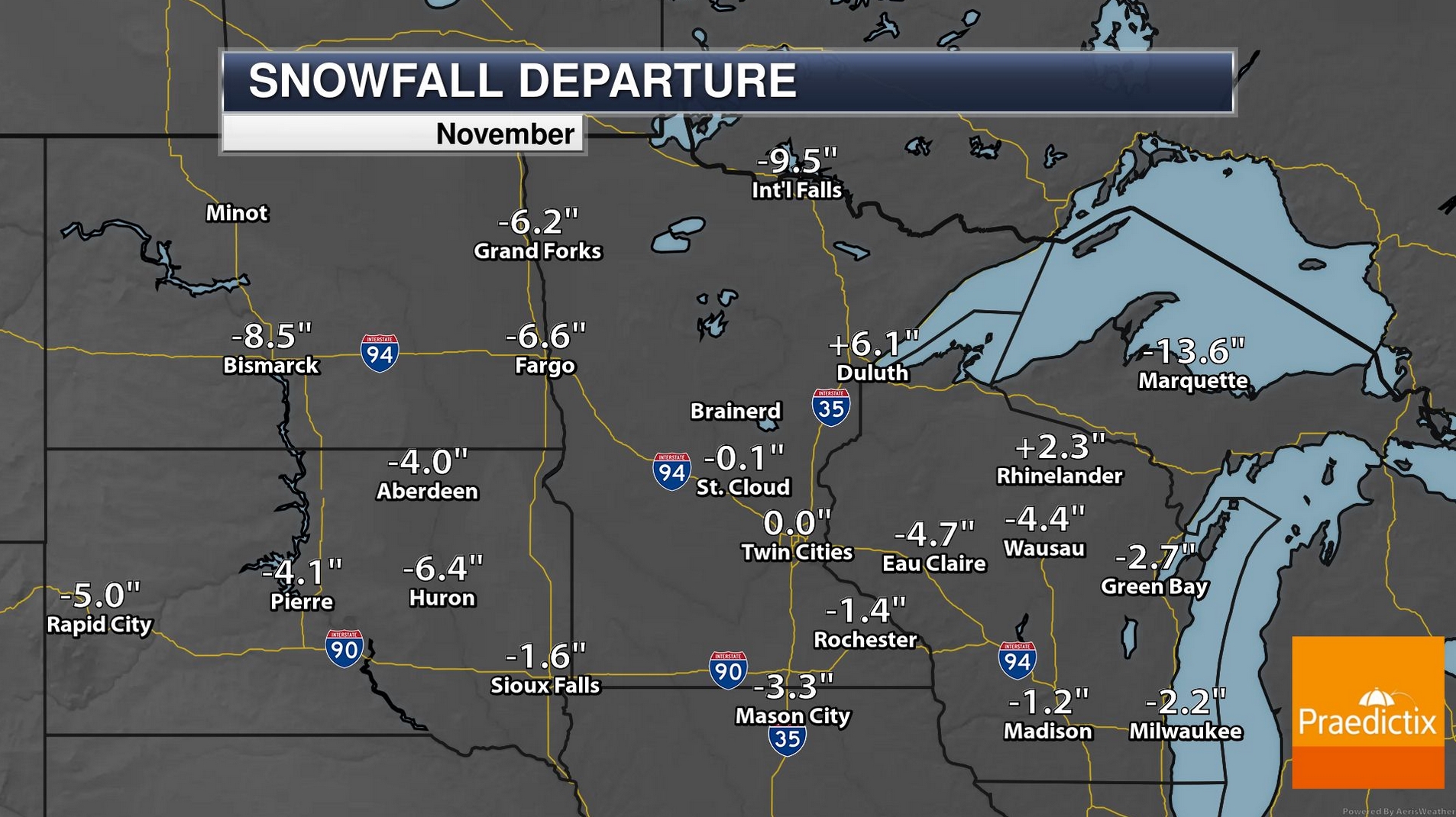
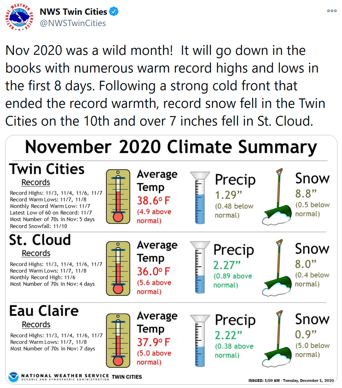
A Perfectly Average November Snowfall for MSP. 8.8″ of snow earlier this month (remember) and then nothing the latter half of the month still adds up to normal 30-year November snowfall for the Twin Cities. A whopping 19.2″ was 6.1″ snowier than normal for Duluth. Map credit: Praedictix and AerisWeather.

Top 7 Warmest Minnesota November on Record? That’s the latest, based on data compiled by Dr. Mark Seeley; here’s an excerpt from Minnesota WeatherTalk: “In contrast to October, this November was very much warmer than normal. Most climate stations report an average monthly temperature that ranges from 4 to 6°F above normal. This means that November of 2020 will likely rank among the top 7 warmest in Minnesota history back to 1895. The week of November 3-9 was the warmest week in November history here. Within the state climate observation network over 200 daily record maximum temperatures were recorded, along with over 120 record warm daily minimum temperatures. For the first time in history Minnesota recorded 4 days during November when the daily maximum temperature reached 80°F or greater…”
Photo credit: Paul Douglas.

Where Will the Next Big Flood Hit? Coastal flooding is increasing, even on days when no storm is nearby. Volunteers are making a big difference. The Atlantic looks at the new challenges facing forecasters: “…Low-lying mid-latitude cities such as Norfolk are especially vulnerable, says geographer James Voogt of the University of Western Ontario, one of the authors of a 2020 article in the Annual Review of Environment and Resources on climate events in urban areas. “You’ve got three things operating in the direction that increases the vulnerability of a city to flooding events,” he says: sea-level rise, increased chances of severe precipitation events, and an abundance of impervious surfaces that prevent water absorption and encourage runoff. As early as 2050, climate scientists predict, the average high tide in the Norfolk area will be equal to today’s king tides. But it’s not just the mid-Atlantic region: Many other parts of the world will be increasingly prone to floods that risk lives and property…”
File image: Citizen’s Committee for Flood Relief.
Climate Central has more perspective and graphical tools showing affordable housing threatening by increased coastal flooding here.
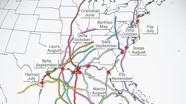
A Very Rough Hurricane Year for Coastal U.S. Residents. CNN.com has a good recap. It’s over now, right? Here’s the intro: “People along nearly every mile of coastline from Texas to Maine have been put on alert this Atlantic hurricane season, as 12 of 29 storms made landfall in the United States in this record-setting year. “Every mile of the US Gulf and Atlantic coast has been under a Tropical Storm or Hurricane Watch or Warning, except for one single county with coastline: Wakulla County, Florida,” said Jake Carstens, meteorology graduate research assistant at Florida State University…”So far this year, 3598 of 3613 miles (99.6%) have been warned,” tweeted James Franklin, the former chief of the Hurricane Specialist Unit at the National Hurricane Center...”

The Race to Crack Battery Recycling – Before It’s Too Late. WIRED.com (paywall) explains the challenge, which will become an opportunity for many new start-ups: “…Redwood is part of a wave of new startups racing to solve a problem that doesn’t really exist yet: How to recycle the mountains of batteries from electric vehicles that are past their prime. Over the past decade, the world’s lithium-ion production capacity has increased tenfold to meet the growing demand for EVs. Now vehicles from that first production wave are just beginning to reach the end of their lifespan. This marks the beginning of a tsunami of spent batteries, which will only get worse as more electric cars hit the road. The International Energy Agency predicts an 800 percent increase in the number of EVs over the next decade, each car packed with thousands of cells. The dirty secret of the EV revolution is that it created an e-waste timebomb—and cracking lithium-ion recycling is the only way to defuse it...”
Image credit: Li-Cycle.
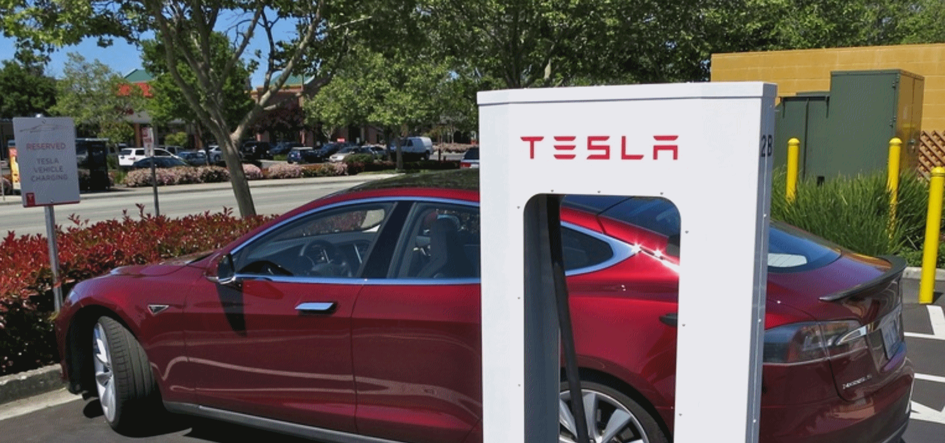
Most Americans Won’t Buy an Electric Car Unless They Get The “Gas Station Experience”. We will transition from gas stations to service stations, with a mix of gas and electric options. Wait for it. Here’s an excerpt from The Mobilist: “…Calise, the executive from Tritium, said the build-out should begin like the Eisenhower-era highway system, with the construction of EV charging corridors. These would involve the construction of EV charging stations every 10 miles or so along the country’s main highways. From there, spokes can be filled in where people live and work, especially inner cities. The problem is that they are expensive, requiring the government to get behind them, Calise said. President-elect Joe Biden is proposing that the federal government subsidize the construction of 500,000 charging stations. If Congress approves funding, charging will be accelerated. “You will start to see them at all the gas stations, convenience stores, hotels, ports, stadiums, fleet depots,” Calise said. “The pure gas station is going to be disrupted…”

Sports Has a Gen Z Problem. The Pandemic May Accelerate It. How many games are you willing to consume on your phone. The Washington Post (paywall) reports: “…The bulky and bankable U.S. sports industry, built on towers of cash and lucrative television contracts, is confronting a Generation Z problem. The nation’s youngest cohort is fundamentally different from the generations that preceded it. Having grown up with smartphones in their pockets, its members eschew traditional television viewing and subscribe to digital habits that make grooming a new generation of sports fans a challenge. That challenge is being met with a sense of urgency in some corners of the sports world and a sense of alarm in others, according to team and league officials, social scientists, research analysts and marketing specialists who focus on Generation Z. Failing to hook young people might not devastate today’s bottom line, but it threatens to muddle the future of every league, every team and every sport…”
Illustration credit: “Sports executives are confronting a Gen Z problem that the pandemic may make worse.” (Anuj Shrestha for The Washington Post).
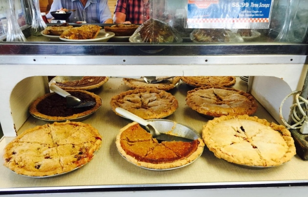
Why Stress-Baking and Cleaning Make You Less Anxious. It’s all about wellness and the ability to disconnect, says a writer at WIRED.com (paywall). Here’s a clip: “…But these are more than desperate attempts at self-soothing. It turns out that homekeeping and self-care activities like meditating, cooking, cleaning, and even just stocking the pantry can help stop cycles of anxiety and depression by changing how the human brain self-regulates. Here’s why stress-baking or cleaning feels so good, neurologically speaking. When humans perceive a threat or stressor, our amygdala—a small region of the brain associated with facilitating fear, anxiety, and emotion—jumps into gear and becomes more active. This activation can have physical consequences, too. Sometimes people who are anxious report feeling short of breath or have an increased heart rate. That’s because the amygdala is also involved in regulating our blood pressure, breathing, and heart. So when the amygdala gets going, those systems do too…”
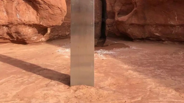
Forecast Calls for More Monoliths. CNET.com has an update: “After the surprising discovery and subsequent disappearance of a monolith in the middle of the Utah desert earlier this month, it seems a similar object has been found in Romania. A structure that appears to be identical to the one in the Utah desert was found on Batca Doamnei Hill in Romania on Nov. 26, according to The Mirror. As was the case with the monolith found in Utah, it’s not clear where this one came from and who installed it. There’s a lot of unknown around the discoveries of these strange objects. When Utah’s Department of Public Safety first found the 2001: A Space Odyssey-esque monolith, people wondered whether it had been the work of aliens, or perhaps artwork by sculptor John McCracken, who died in 2011…”
Photo credit: “After this monolith was discovered (before disappearing) in Utah, another was apparently spotted in Romania.” Utah Department of Public Safety Aero Bureau.
37 F. high in the Twin Cities yesterday.
32 F. average MSP high on December 1.
32 F. maximum temperature on December 1, 2019.
December 2, 1985: Record low highs are set in north and east central Minnesota with temperatures ranging from the single digits below zero to the singles digits above. Alexandria was the cold spot with a high of 4 degrees Fahrenheit below zero. Other record low high temperatures included Redwood Falls with 3 below, Long Prairie with zero, and Litchfield and Little Falls with 5 degrees above zero.
December 2, 1982: A record high of 63 degrees is set at the Twin Cities.
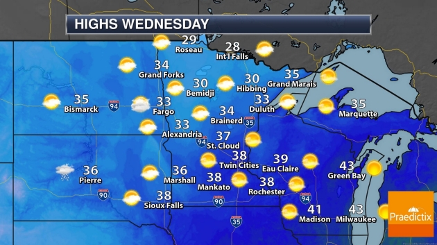
WEDNESDAY: Blue sky, tranquil. Winds: W 5-10. High: near 40
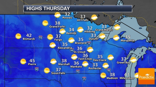
THURSDAY: Sunny, milder than average. Winds: W 7-12. Wake-up: 26. High: 40
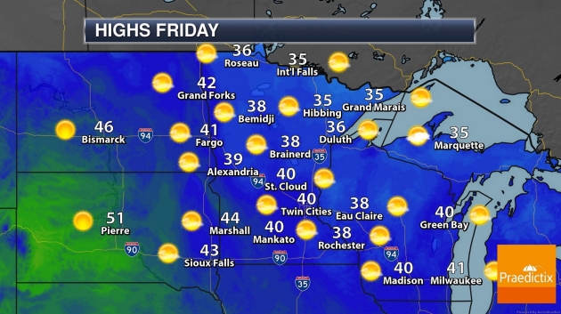
FRIDAY: Partly sunny skies. Winds: NW 8-13. Wake-up: 27. High: 39
SATURDAY: Sunshine, still amazingly quiet. Winds: NW 7-12. Wake-up: 28. High: 41
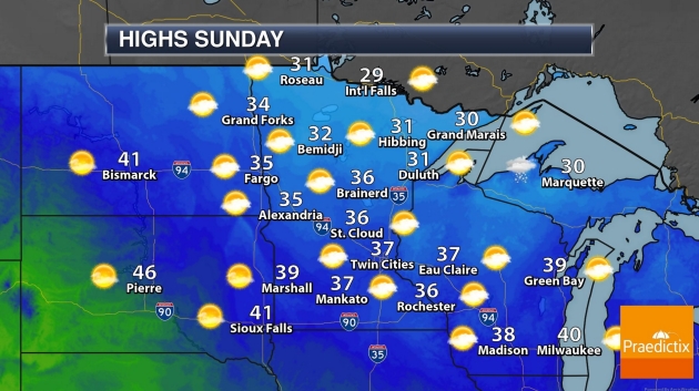
SUNDAY: More clouds, cooler winds. Winds: NW 10-20. Wake-up: 29. High: 35
MONDAY: Sunny, still no weather to report. Winds: W 5-10. Wake-up: 28. High: 39
TUESDAY: Partly sunny. Snow lovers bummed. Winds: SW 8-13. Wake-up: 29. High: 43