
The United States of Weather Extremes
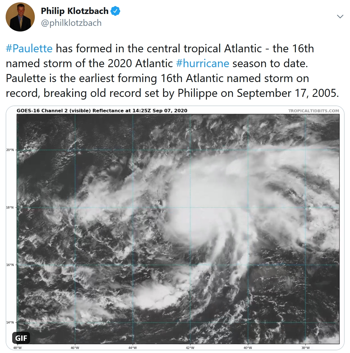
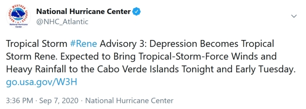
2020 has been a volatile, jaw-dropping year – and disruption applies to America’s weather. In recent days I’ve witnessed things I’ve never seen before. 121F in the suburbs of Los Angeles. A 5 year drought fueling massive California wildfires, billowing smoke thousands of miles downwind. While the west bakes Denver just dropped 60 degrees in 2 days; from 100F to 30s and snow, in a meteorological blink of an eye. “Paulette” has formed in the Atlantic, the 16th storm and earliest P-name on record. And now there’s Tropical Storm Rene, the earliest R-name on record.
Our instant autumn continues, after a warm, wet summer. Dr. Mark Seeley says the summer months will rank 17th wettest and top four warmest on record, statewide.
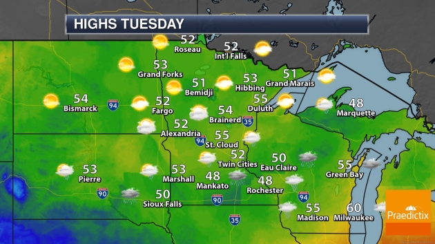
A stalled frontal boundary sparks rain from this afternoon into Wednesday, with temperatures 20-25F below
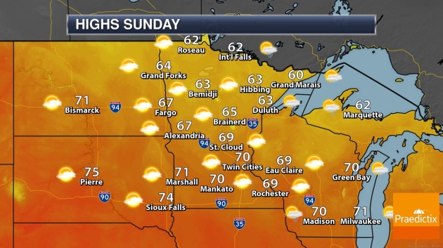
average. Showery rains return late Friday into Saturday, but we salvage sunshine and low 70s on Sunday.
Yes, we will see more spasms of warmth, more 70s and a few 80s. My closet is a jumbled mess: jackets and shorts, together.
No shame in that.
Image credit above: NOAA.
2020: One of the Four Warmest Summers on Record for Minnesota. So says Dr. Mark Seeley at Minnesota WeatherTalk: “…On a statewide basis this was one of the top 4 warmest summers in history (since 1895, averaging nearly 3 degrees F above normal for all three months combined. The summer of 1988 remains the warmest in state history, but 2020 will follow close behind with 1933 and 1983. Within the climate station network of Minnesota this summer 135 daily maximum temperature records were set or tied, while 143 warm daily minimum temperature records were set or tied. The highest temperature was 102°F at Granite Falls on June 7th. In addition, Benson, Sabin, Artichoke Lake, Milan, and Morris all reported at least one day with 100°F as well...”
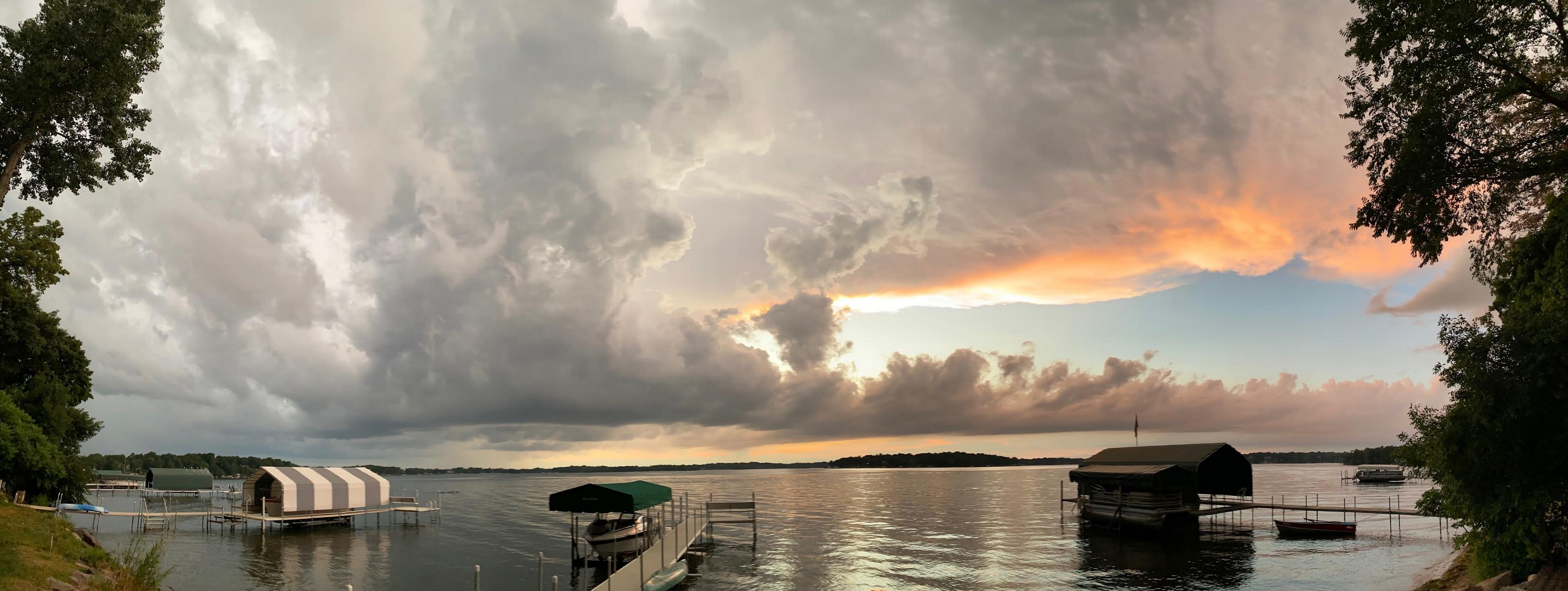
Photo credit: Paul Douglas.
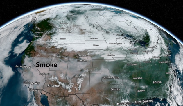
Massive Smoke Plume. The smoke from scores of fires raging from California to Colorado encompasses much of the southwestern USA. Remember, we are at the beginning of the traditional fire season for western states. Image credit: AerisWeather.
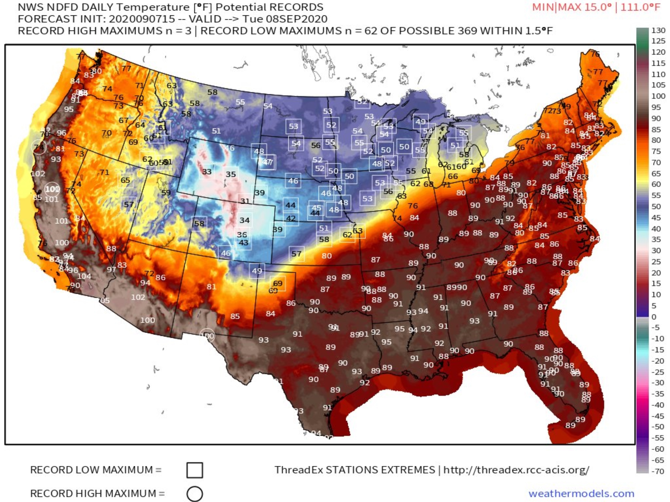
Crazy Extremes. The map above shows predicted daytime highs on Tuesday (NOAA NDFD data) and potential records (boxed) across the USA. Nothing like easing into autumn. Map credit: weathermodels.com.
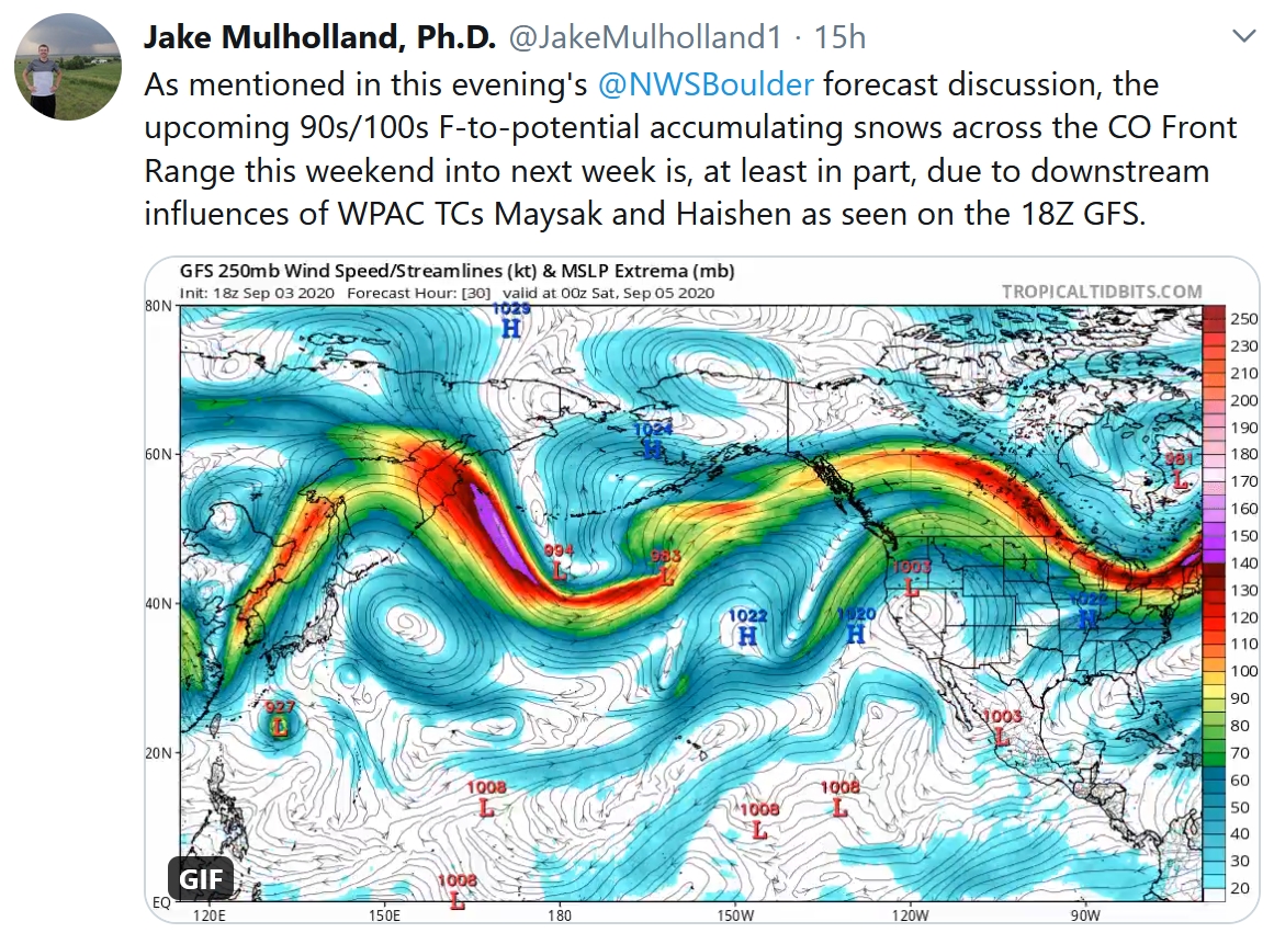
Everything is Connected. Typhoons in the western Pacific helping to amplify weather patterns thousands of miles downwind? Happens more than you suspect.
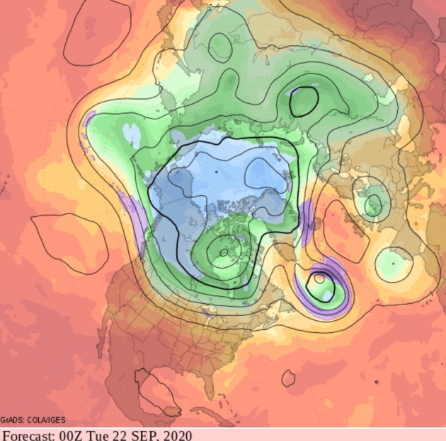
What’s That Blue Stuff? Wet snow for the Nebraska Panhandle. Consider this a shot across the bow. No accumulating snow for Minnesota anytime soon, but the maps are looking more like late September – early October. Future radar loop courtesy of NOAA (NAM model), Praedictix and AerisWeather.

Frequent Cool Frontal Passages. The south and west is forecast to bake for most of September, but a series of Canadian swipes will take the edge off the heat for northern tier states, if NOAA’s GFS model looking out 2 weeks is to be believed.
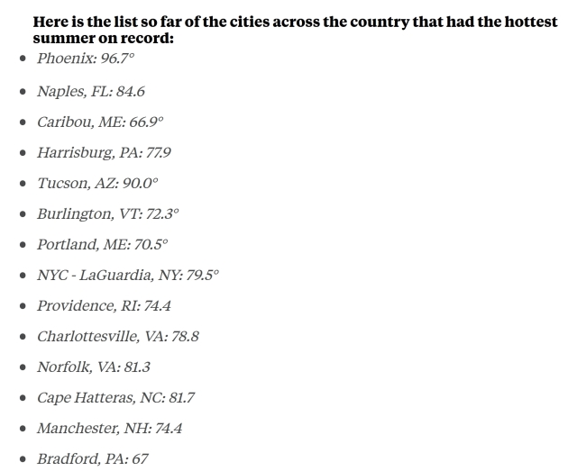
2020 Was Hottest Summer on Record for Dozens of US Cities. ABC News explains: “…Some of the nation’s largest cities recorded their hottest climatological summers on record this year, including destinations like Phoenix, Tucson and Sacramento, according to the National Weather Service. In Phoenix, the country’s sixth-largest city, residents saw average temperatures of about 96.7 degrees — almost 1.6 degrees above the previous summer record, the NWS said Wednesday…Meanwhile, cities like Palm Springs, Las Vegas, Vero Beach, Florida, Flagstaff, Arizona and Sarasota, Florida, saw their hottest August temperatures ever...”
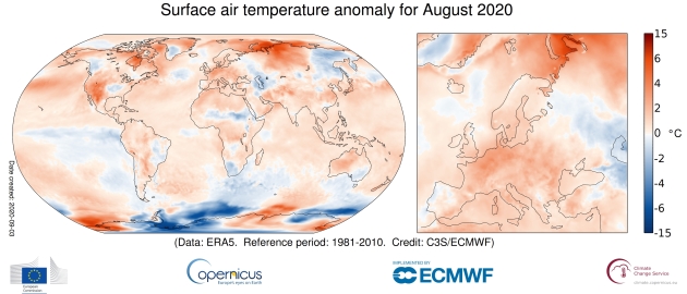
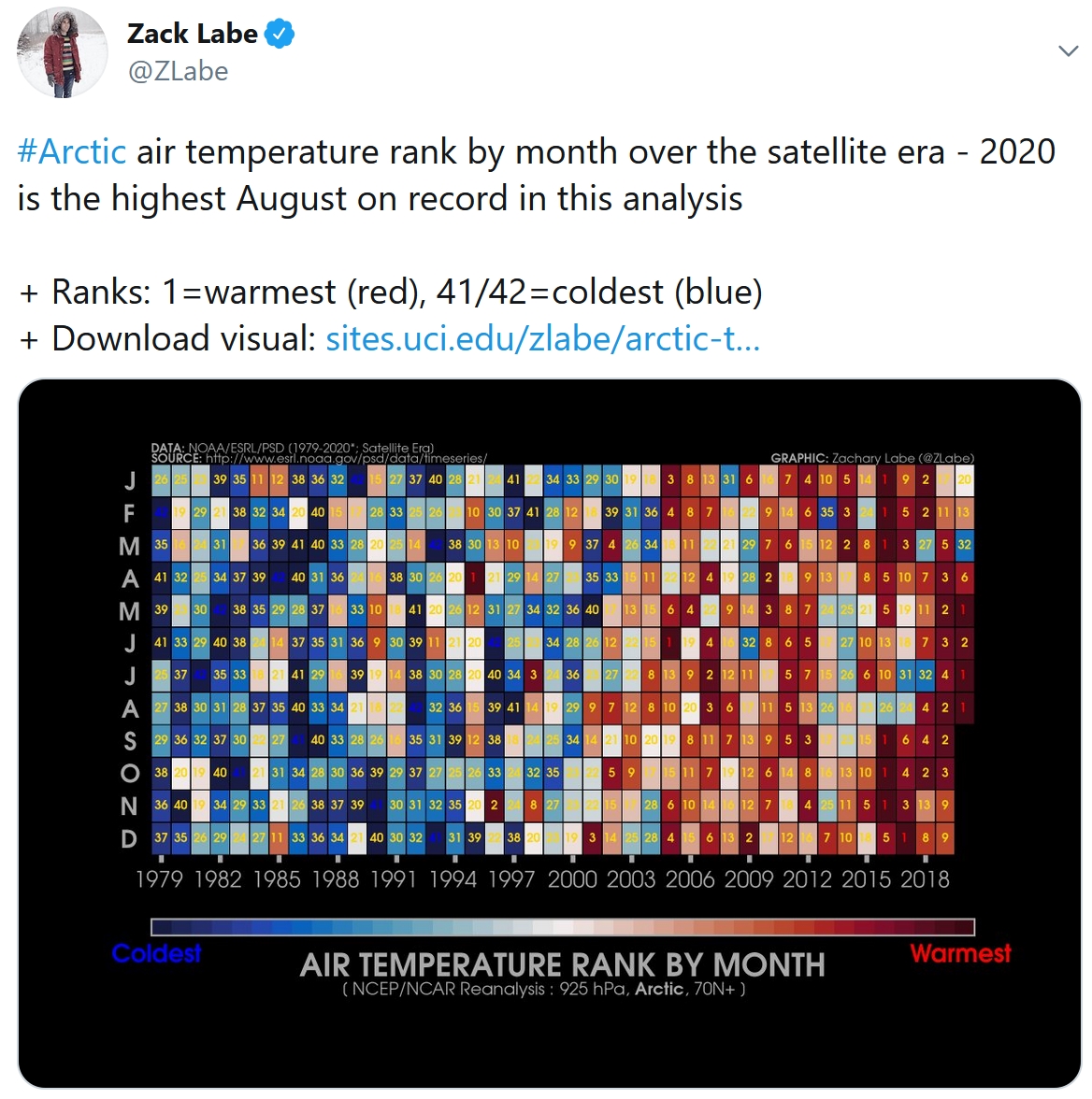
August 2020 Heat: World’s Fourth Warmest on Record. Bloomberg reports: “August 2020 will go down as the fourth-warmest on record worldwide, with above average summertime heat in the U.S. and Mexico tempered slightly by below average temperatures in parts of the Southern Hemisphere. Global temperatures for the month spiked around 0.9 degrees Celsius above the historical average, according to a new report by Europe’s Copernicus Climate Change Service. That reading came in lower than the summers of 2018 and 2019, the agency said in a statement...”
Image credit: Copernicus.
Praedictix Briefing: Issued Monday morning, September 7th, 2020:
Southwest Heat Concerns

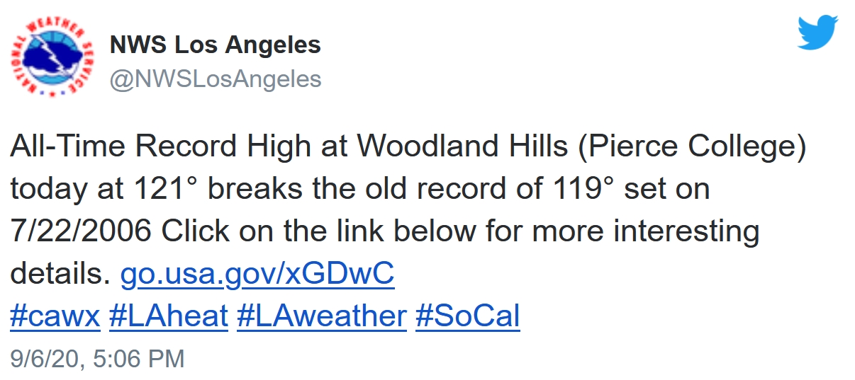
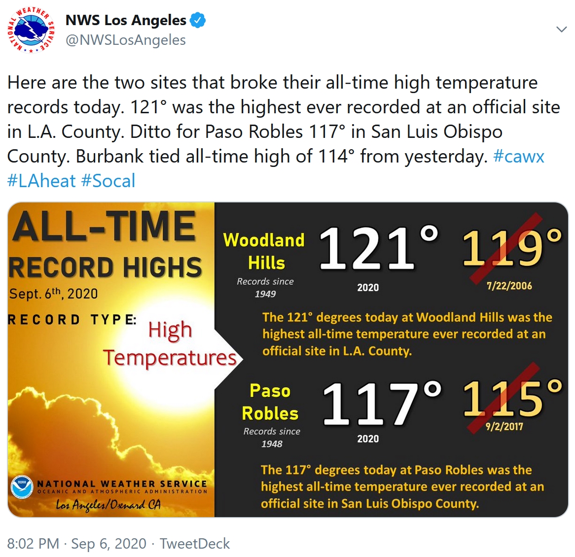
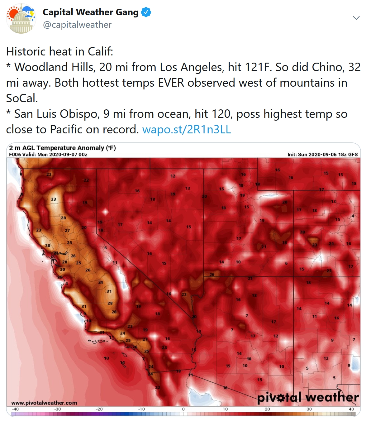
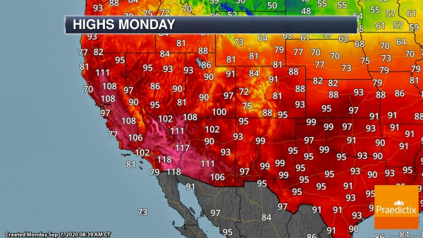
Excessive Heat Warnings. We are tracking a dangerous, historic heat wave across the Southwest continuing today across the region. Yesterday, Downtown Los Angeles (111F) saw their third warmest high in recorded history with Downtown San Francisco (100F) tying for their eighth warmest day on record. Meanwhile, the warmest temperature ever recorded in Los Angeles County (121F – Woodland Hills) and San Luis Obispo County (117F – Paso Robles) occurred yesterday as well. Dangerous, record breaking heat will continue across the region today with Excessive Heat Warnings in place, though it should likely be slightly cooler than yesterday in the Los Angeles and San Francisco areas. Here’s a look at expected highs today across the region:
Extreme Fire Danger
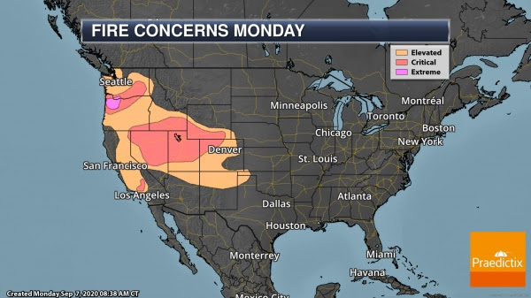

Extreme Fire Danger Today. Meanwhile, the fire danger is ramping up quickly across the western United States. Due to a strong area of high pressure pushing south into the northern U.S. Rockies and a trough along the Pacific Coast, very strong offshore winds are expected across portions of the Pacific Northwest, in and around the Portland area, today. Widespread winds of 20-30 mph with gusts above 60 mph in higher elevations along with low humidity values and very dry fuels are leading to an Extreme Fire Danger. However, other areas of Critical Fire Danger are in place across the western United States due to very dry fuels (which the recent heat waves had contributed to), low humidity values, and gusty winds. Some of this is due to a strong cold front sinking south across northern California/southern Oregon eastward, and just due to the heating of the day in southern California.
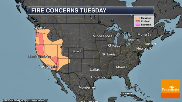
Fire Danger Continues Tuesday. Critical fire danger will continue across several areas of the western United States Tuesday due to the continued low humidity values, gusty winds, and very dry fuels. As we head toward late Tuesday and into Wednesday, a Santa Ana wind event is expected across southern California.
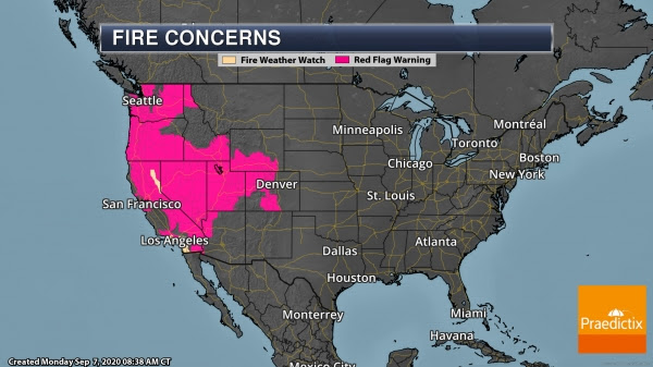
Fire Weather Watches/Warnings. Due to the expected volatile fire weather conditions across the western United States, a wide area is under Fire Weather Watches and Warnings.

Ongoing Fires. Of course, we are still tracking numerous wildfires across the region – of which these expected weather conditions will not help containment. Of note are a couple of fires:
- The Creek Fire started Friday started near the communities of Big Creek and Huntington Lake in California and has quickly grown. Over 200 people had to be rescued from the Mammoth Pool Reservoir this weekend due to this wildfire. It has burned over 73,000 acres and is 0% contained.
- The Cameron Peak Fire started in Colorado back on August 13 and has burned over 59,000 acres with 4% of it contained. This fire has been pushing smoke into the Denver metro.
Get more information on wildfires burning out west from:
- CalFire (California only): https://www.fire.ca.gov/incidents/
- InciWeb: https://inciweb.nwcg.gov/
September Snowstorm


Winter Storm Warnings. Meanwhile, an area of low pressure will be dropping south into the Four Corners region as we head through today into Tuesday, bringing a dramatic blast of cold air and snow across the Rockies into the Front Range over the next couple of days. Snow will also be possible into the Black Hills of South Dakota. Ahead of this September snowstorm, Winter Weather Advisories and Winter Storm Warnings are in place, including in the following areas:
- Casper, WY: Winter Storm Warning from 6 PM tonight through Noon Tuesday for 5-8″ of snow and wind gusts to 45 mph.
- Cheyenne, WY: Winter Storm Warning from Midnight tonight through 6 AM Wednesday for 5-10″ of snow and wind gusts of 35-45 mph.
- Denver, CO: Winter Weather Advisory from Midnight tonight through Noon Wednesday for 3-7″ of snow.
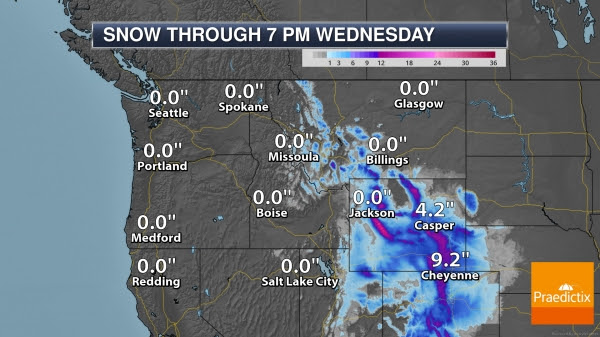
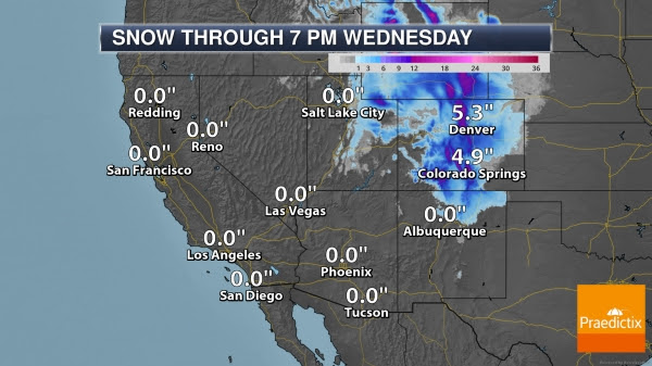
Snow Forecast. The heaviest snow will fall in the mountains at higher elevations where over a foot could be possible. Our forecast right now has Cheyenne picking up around 9” of snow with Denver seeing around 5” through the duration of the storm.
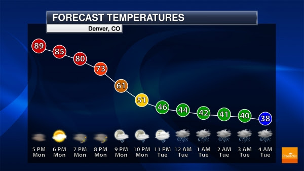
Denver Temperature Drop. Temperatures will quickly drop across the Denver metro as we head into the overnight hours. Highs in Denver today will top off in the low 90s, but quickly drop through the late evening hours to around 50F by 10 PM and into the 30s by early Tuesday morning with precipitation changing from rain to snow.
Atlantic Tropical Update
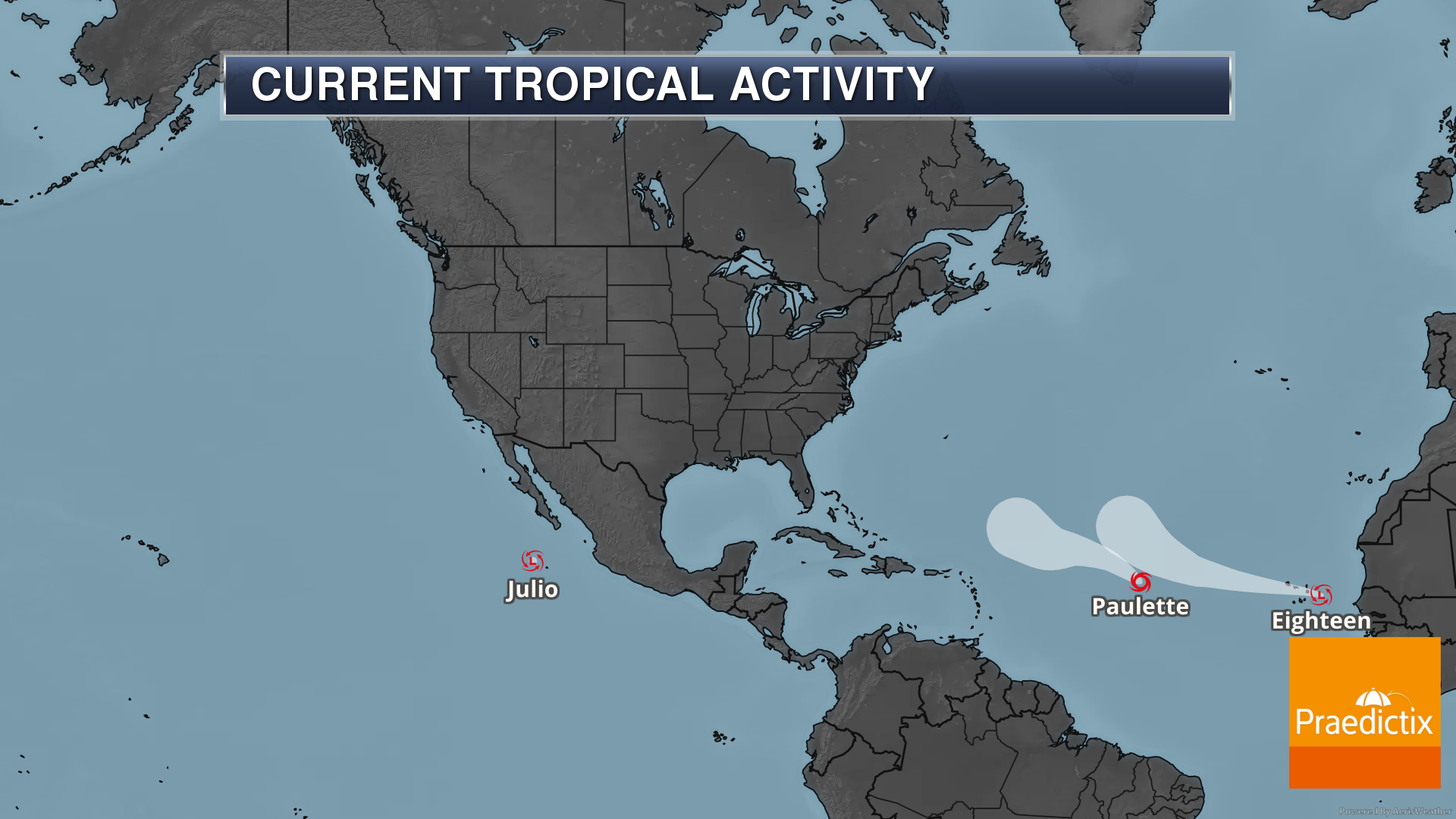
Paulette And Eighteen Forms. As we look at the Atlantic, we are tracking two named system out in the central and eastern Atlantic. Tropical Storm Paulette poses no threat to land over the next five days as it continues to move west-northwest to northwest. Some gradual strengthening is expected the next couple of days before it starts to weaken. We’re also tracking Tropical Depression Eighteen out near the Cabo Verde Islands. That system is expected to become a Tropical Storm later today and due to that Tropical Storm Warnings are in place for the Cabo Verde Islands. It looks to strengthen into a hurricane later this week but should curve northward. We’re also tracking an area of low pressure south of Bermuda that has a low (30%) chance of development as it continues to move westward. Meanwhile, another tropical wave will move off Africa in a few days with gradual development expected after that time (40% chance of development in the next five days).
D.J. Kayser, Meteorologist, Praedictix.

Does Warm Weather Impact Covid-19? There are no conclusive results (that I’m aware of) that indicate that hot weather reduces the odds of infection. Big Think analyzes some of the factors in play: “…One factor, according to Sciencing, that may increase your susceptibility in cold weather is how your sinuses respond to the humidity and temperature changes. Your nose is a natural air filter for your body. When you spend time in cold temperatures, your nasal passages dry out due to the constriction of blood vessels…One common reason why virus infections may become more common during cold months is that more people are spending time indoors (and together). As research has determined, social distancing can heavily impact the spread of the COVID-19 virus. Being clustered closer together indoors can increase the likelihood of transmission, giving the effect of the virus spreading faster in the colder months…”
File image: CDC.

How to Handle a Jerk. I needed this advice from The Wall Street Journal (paywall) now more than ever. This applies to social media, too. Don’t engage, just mute, block or walk away. Here’s an excerpt: “…Dealing with an everyday jerk is a two-part process. Part one: Do not engage. Once the jerkiness comes out—in your example, when the guy began berating you for pointing out his error—separate yourself from the encounter. Remember: You’re extremely unlikely to change someone else’s bad behavior. And the more you call that person out, the more likely he or she is going to get defensive and double down on it. Keep calm and remain polite. Remove yourself physically if possible. Take some comfort in the fact that unless the person is a straight-up sociopath, he or she probably feels some sense of shame when left alone acting like an idiot...”
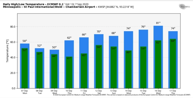
64 F. maximum MSP temperature on Labor Day (shortly after midnight).
75 F. average high on September 7.
67 F. Twin Cities high temperature on September 7.
September 8, 1985: An F1 tornado touches down in Faribault County causing $25,000 worth of damage, and hail up to 1 3/4 inches falls in Freeborn and Waseca Counties.
September 8, 1968: 1 3/4 inch hail falls in Goodhue County.
September 8, 1931: A record high is set in St. Cloud with a temperature of 102 degrees Fahrenheit.

TUESDAY: Dry start, PM rain. Winds: NE 10-20. High: 52
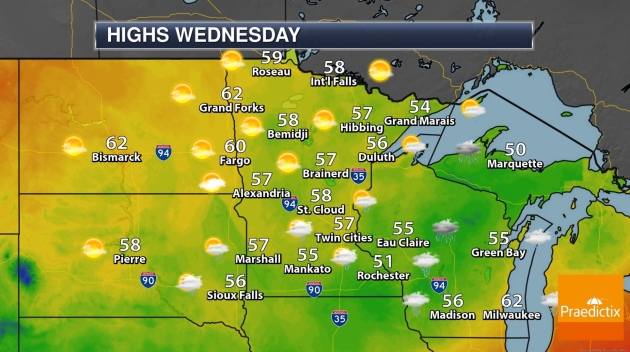
WEDNESDAY: More light rain and drizzle. Winds: NE 7-12. Wake-up: 45. High: 53
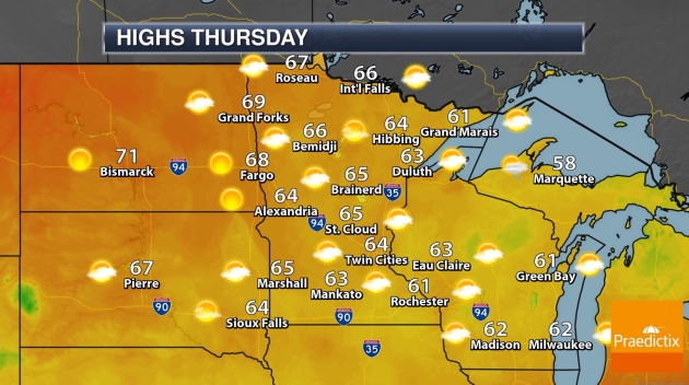
THURSDAY: Behold, the sun! Comfortable. Winds: S 3-8. Wake-up: 44. High: 63
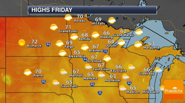
FRIDAY: Sunny start, PM showers, T-storms. Winds: SE 10-15. Wake-up: 49. High: 66
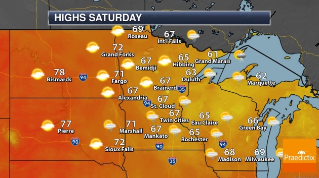
SATURDAY: Unstable with more pop-up showers. Winds: NW 7-12. Wake-up: 56. High: 69
SUNDAY: Nicer day, plenty of sunshine. Winds: NW 5-10. Wake-up: 54. High: 68
MONDAY: Partly sunny, milder breeze. Winds: S 10-15. Wake-up: 50. High: 74
Climate Stories…
Climate Whiplash: Wild Swings in Extreme Weather Are on the Rise. Yale E360 explains: “…These wild swings from one weather extreme to another are symptomatic of a phenomenon, variously known as “climate whiplash” or “weather whiplash,” that scientists say is likely to increase as the world warms. The intensity of wildfires these days in places like California are a symptom of climate change, experts say, but the whiplash effect poses a different set of problems for humans and natural systems. Researchers project that by the end of this century, the frequency of these abrupt transitions between wet and dry will increase by 25 percent in Northern California and as much as double in Southern California if greenhouse gasses continue to increase…”
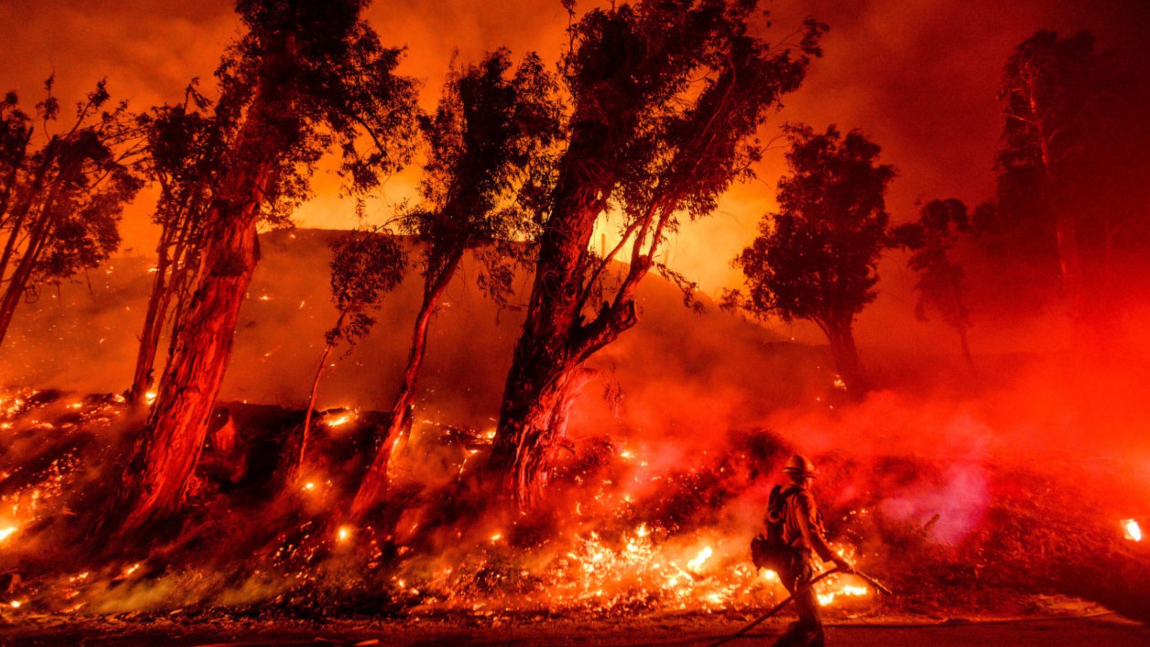
File photo: “Firefighters battle the Maria Fire in Santa Paula, California on November 1.” AP Photo/Noah Berger.
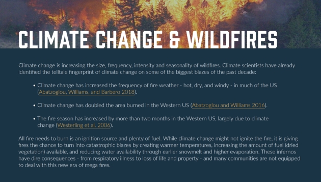
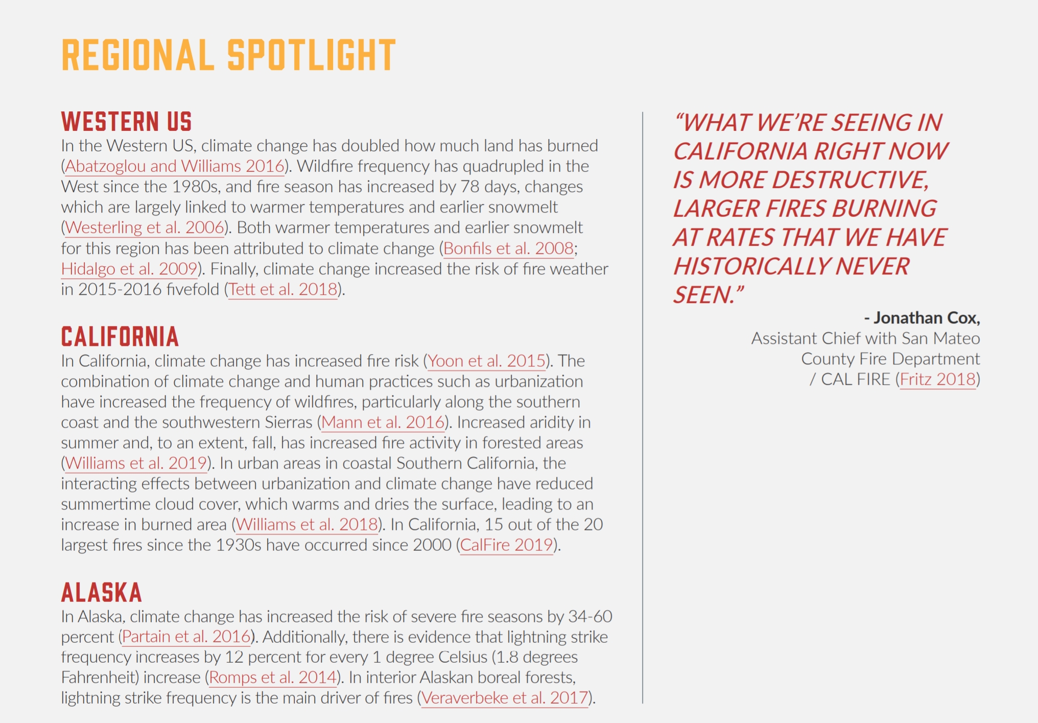
Connecting the Dots. A consistently hotter, drier climate is helping to fan the flames of larger, longer, more extreme fires, especially California. Graphics above courtesy of Envent Lab.
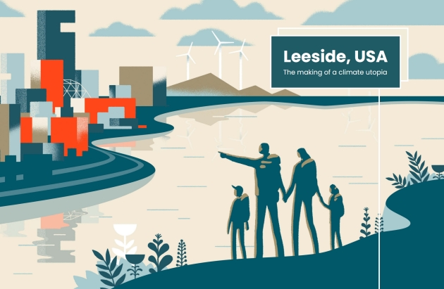
Leeside, USA: The Making of a Climate Utopia. There is no Leeside (yet) but every community will have to use new methods and materials to build resilience, no matter what a more volatile climate throws at us. Here’s an excerpt from Quartz: “It’s 2057 and no life has been untouched by the realities of a warming globe. But mere decades ago, at the dawn of the 21st century, Americans were only just waking to this truth. Rising seas, powerful storms, and raging fires were destroying their cities, rendering homes uninhabitable, and dismantling livelihoods. Residents affected by such loss began to ask, “Where will we go?” In an increasingly isolationist world, many responded, “Not here.” But Leeside opened its doors. And after years of implementing innovative policies benefiting both the environment and the city’s residents, the United Nations inaugurated Leeside as the United States’ first Green Haven in 2035. Now, the city is recognized as a model of successful adaptation—physical, economic, and social—to a world in which cities and their communities are transformed by the millions seeking shelter from the storm...”
Democratic Leaders Want to Know Why Facebook’s New Oversight Board Won’t Deal with Climate Lies. Seems like we have an algorithm (or oversight) problem, according to Mother Jones: “…The dispute is over a loophole in Facebook’s leaky fact-checking operation that has allowed climate change deniers to circumvent fact-checkers and spread misinformation meant to mislead readers about the reliability of climate modeling. E&E News’ Scott Waldman reported how the denier group CO2 Coalition has been able to run ads on Facebook based on claims that aren’t supported by peer-review climate science. In one instance last year, Waldman found that independent fact-checkers flagged the post as false, temporarily blocked it, but a conservative staffer at Facebook overrode them to remove the false label. Ever since, the CO2 Coalition was able to share its false content because Facebook categorized it as “opinion” and therefore exempt from fact-checking...”
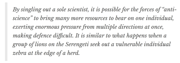
IPCC: the Dirty Tricks Climate Scientists Faced in Three Decades Since First Report. The Conversation lays out a persistent campaign of deception and disinformation: “…In 1996, there were sustained attacks on climate scientist Ben Santer, who had been responsible for synthesising text in the IPCC’s second assessment report. He was accused of having “tampered with” wording and somehow “twisting” the intent of IPCC authors by Fred Seitz of the Global Climate Coalition. In the late 1990s, Michael Mann, whose famous “hockey stick” diagram of global temperatures was a key part of the third assessment report, came under fire from right-wing thinktanks and even the Attorney General of Virginia. Mann called this attempt to pick on scientists perceived to be vulnerable to pressure “the Serengeti strategy”…”

How Kids are Inspiring Adults to Address Climage Change. Here’s an excerpt of a post at NC State News: “…As we all know, climate change is a highly politicized issue. Political ideology is consistently one of the major drivers of climate change perceptions, regardless how much people understand science. This might be because politics influences the types of information we seek and how we interpret it. In fact, one study found that the climate change risk perceptions of people who are better at science and numbers are more polarized. Kids, however, seem to behave in the opposite way. We did a study in 2012 that found that at low levels of climate change understanding, kids are just as polarized as adults. But, when they learn more about the science behind climate change, the ideology-driven polarization disappears…”

The Sitting President Has No Climate Plan. Why Isn’t That Headline News? Maybe it gets lost amid the chaos, denial and campaign donations? Here’s an excerpt from The Columbia Journalism Review: “THE PRESIDENT OF THE UNITED STATES has no plan to address the climate crisis. This is not a partisan observation; it is a fact, supported by Donald Trump’s own statements and the Republican Party platform, which, as in 2016, outrightly dismisses the climate threat and ridicules efforts to mitigate it. On August 23, the eve of the Republican National Convention, the president’s team released a bulleted list of Trump’s priorities for a second term. The word “climate” did not appear once. Given the unparalleled and scientifically incontrovertible threat that climate change presents, this is shocking, though it is not a surprise...”