
Wet October So Far
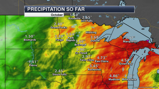
Precipitation has been one of the larger stories this month across the state, with many NWS climate sites reporting over 2″ of rain so far in October. Areas like Rochester, Duluth, and Brainerd, are already over 3″, with the Twin Cities and St. Cloud close to that tally. In the Twin Cities, 11 days (out of the first 24) have received at least a trace of precipitation – already tied for the 27th most on record for the month of October. Assuming we receive rain each day from Thursday through Sunday (rain is in the forecast each of those days), that would push us up to a tie for 4th place. The most days with at least a trace of precipitation in October was 17 days back in 2009.
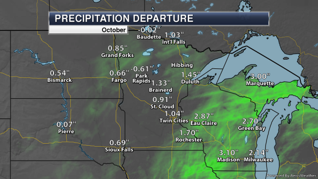
In most areas, these precipitation totals are above average for this late in the month, with the greatest departure from average values found across southeast Minnesota.
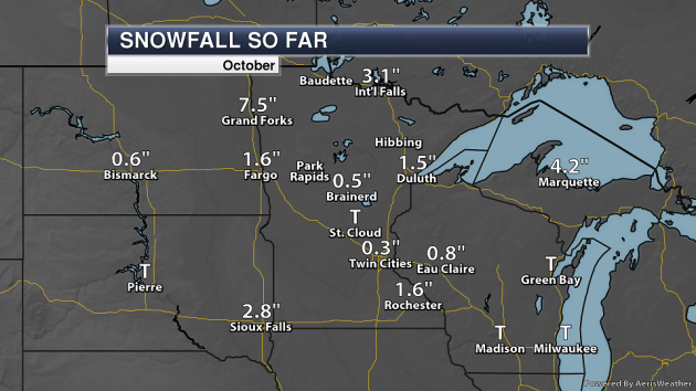
Some of this precipitation has fallen in the form of snow. Already 0.3″ of snow has fallen in the Twin Cities, but over 3″ has already fallen in International Falls. If no additional snow fell in International Falls this month, it would be the 18th snowiest October on record.
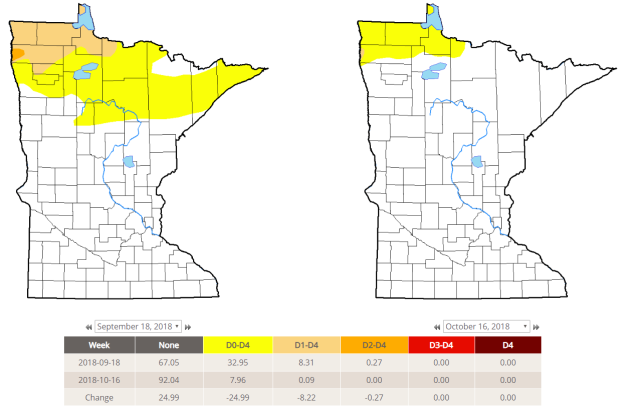
The recent precipitation has helped the drought situation across northern Minnesota. On September 18th, ~33% of the state was abnormally dry with 8.3% of Minnesota in Moderate Drought. That is now down to ~8% and a minuscule 0.1%, respectively, in the Drought Monitor update last week. The next update is released on Thursday.
_______________________________________________
National Weather Forecast
The area of low pressure that has been bringing Texas rain this week will finally start to move off to the northeast on Thursday, bringing rain chances to the lower Mississippi Valley and into the Southeast. Another area of low pressure moving across the Northern Plains will bring the chance of light rain along with it. A frontal system moving through the Pacific will bring rain to the region as well as light snow to the Washington Cascades and the northern Rockies.
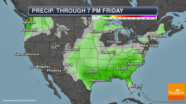
A couple areas of heavier rain will be possible through Friday across the country. From Texas into the Southeast, a widespread area of 1-3″ of rain will be possible. Over three inches of precipitation will be possible across parts of the Olympics and Cascades.
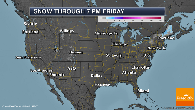
Several inches of snow will be possible across parts of New England through Wednesday Night. Light snowfall amounts are possible in parts of the Rockies and Cascades through 7 PM Friday.
_______________________________________________
Oregon, already mired in drought, projected to have warm winter with low snowpack
More from the Salem Statesman Journal: “On the heels of a drought-stricken summer and fall, Oregon is expected to stay warm into this coming winter. Long-term forecasts project a 50 to 60 percent chance of a warmer-than-normal winter likely to include low snowpack, according to NOAA’s Climate Prediction Center. The extended forecast, which includes December to February, says a weak El Nino loads the dice toward warm and dry conditions in the Northwest, meteorologists said. “Historically, winters with a weak El Nino bring warmer temperatures and lower snowpack,” said Jeremiah Pyle, a meteorologist with the National Weather Service in Portland. “It doesn’t always end up like that,” he said, “but some of the worse winters we’ve had have been in weak El Nino years.””
This year’s drought was good for melons, but bad for farmers
More from 9NEWS Denver: “This year’s drought has been rough on many of Colorado farmers and ranchers – but it was actually close to perfect for the melon growers of southeast Colorado. The first freeze of the season came to southeast Colorado the morning of Oct. 14. This marked the end of the growing season, and the Rocky Ford Growers Association is reporting a bumper harvest. This includes two million cantaloupes, one million watermelons, and 150,000 honeydews. That’s an impressive yield, considering the plants spent the summer in extreme drought conditions. “It’s almost backwards of what you might think,” said Michael Hirakata, the owner of Hirakata Farms in Rocky Ford. “We are kind of opposite of, say, a wheat farmer or a rancher.””
A Climate Catastrophe Paved the Way for the Dinosaurs’ Reign
More from The Atlantic: “In Italy, the dawn of the greatest empire in the history of the world is marked, not by broken marble pediments strewn across the seven hills of Rome, but modest three-toed footprints pressed into rocks far to the north, high in the Italian Alps. They were left by coastal dinosaurs patrolling the tidal flats of a tropical lagoon over 230 million years ago, and they’re among the earliest in Earth’s history. Perhaps more remarkable, though, than this sudden appearance of dinosaurs in ancient Europe, are the strange rocks which host them. The legendary reptile trackways appear just above crumbling bands of red clay that cut through the cream-colored peaks of the Dolomites—a striking dash in the strata that marks one of the most bizarre climate events ever. Almost a quarter-billion years ago, rains soaked the arid wastes of the supercontinent Pangaea for more than a million years. When the floodwaters retreated, a new world was born.”
Some of the countries leading on climate change might surprise you
More from The Guardian: “On climate change, countries that may not be thought of as climate leaders are emerging at the front-lines on responding to climate change. One great example is Iran. I have the fortune of performing water-use research with a number of scientists in Iran. And I can assure you they are thinking about, planning, and taking action to reduce the impacts of climate change and ecological destruction. One example of an Iranian leader is Dr. Mohammad Taghi Sattari who is an Associate Professor of water engineering at the University of Tabriz. He recently wrote a report about an effort in Iran to handle their water availability crises. It probably doesn’t surprise people that Iranians think about water availability; it is a country with limited rainfall. And the concurrence of three issues (water management, growing population, and climate change) make this is particularly challenging problem.”
_______________________________________________
Thanks for checking in and have a great Thursday! Don’t forget to follow me on Twitter (@dkayserwx) and like me on Facebook (Meteorologist D.J. Kayser)!
– D.J. Kayser
