
Heavy Snow Sunday Night Into Monday
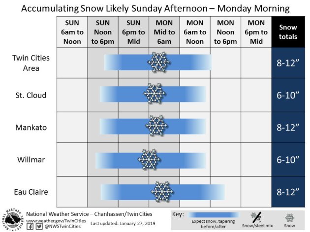
Snow is working its way toward the Twin Cities through the late afternoon hours on Sunday, and once it gets here it will continue through the mornings hours Monday. Here’s a look at timing for select cities across southern and central Minnesota and western Wisconsin, courtesy of NWS Twin Cities. This snow will impact the morning commute on Monday, so if you have to hit the roads please allow extra time to make it to your destination!
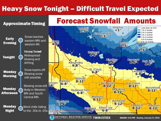
Winter Storm Warnings continue into Monday across parts of central and southern Minnesota for the potential of at least 6″ of snow, including the Twin Cities. Here’s the text of the Winter Storm Warning in effect for the Twin Cities:
Chisago-Wright-Hennepin-Anoka-Ramsey-Washington-Carver-Scott-Dakota-Goodhue-
Including the cities of Center City, Monticello, Minneapolis, Blaine, St Paul, Stillwater, Chaska, Shakopee, Hastings, and Red Wing
325 PM CST Sun Jan 27 2019
…WINTER STORM WARNING REMAINS IN EFFECT UNTIL NOON CST MONDAY…
…WIND CHILL WATCH REMAINS IN EFFECT FROM TUESDAY AFTERNOON THROUGH THURSDAY MORNING…
* WHAT…Heavy snow. Dangerously cold wind chills possible. Additional snow accumulations of 7 to 11 inches with isolated locations close to a foot of snow. Wind chills as low as 50 below zero likely.
* WHERE…Portions of central, east central and southeast Minnesota.
* WHEN…For the Winter Storm Warning, until noon CST Monday. For the Wind Chill Watch, from Tuesday afternoon through Thursday morning.
* ADDITIONAL DETAILS…Travel could be very difficult. Patchy blowing snow could significantly reduce visibility. The hazardous conditions could impact the morning or evening commute. The dangerously cold wind chills could cause frostbite on exposed skin in as little as 5 minutes.
_______________________________________________
Life-Threatening Stretch Of Cold Weather This Week
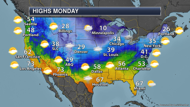
The cold stretch of weather that has been advertised the past few days is almost here – I’ll start you off by looking at the bitterly cold highs and lows expected Tuesday through Thursday across the state.
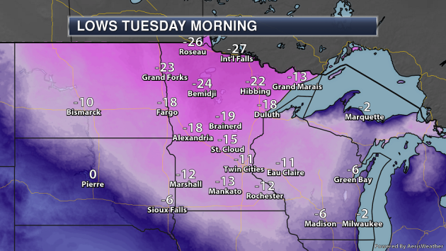
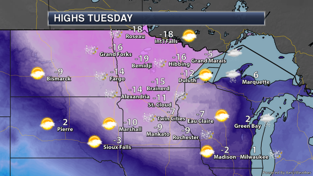
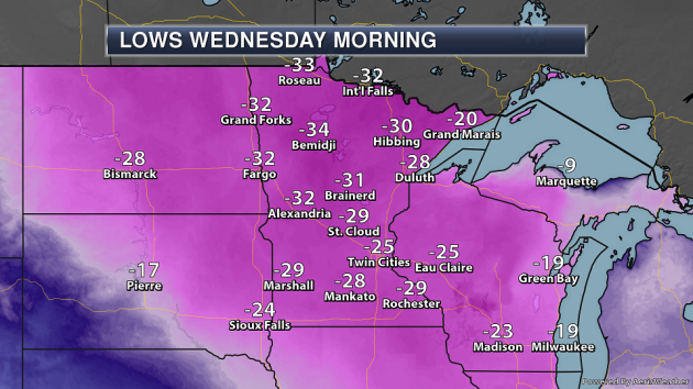
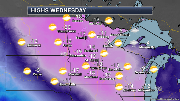
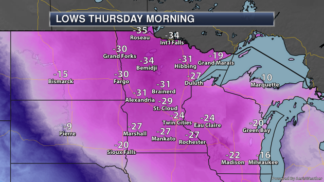
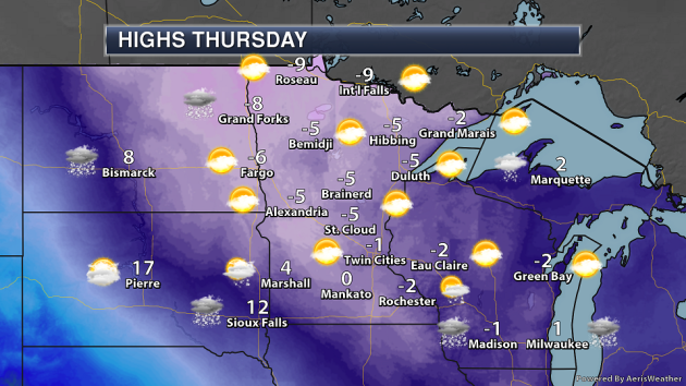
While the cold air starts to settle in Tuesday, the coldest day across most of the state will be Wednesday when highs won’t make it out of the double digits below zero in most locations. Right now it looks like we’ll have three days of below zero highs in the Twin Cities. Meanwhile, if International Falls can stay below zero Monday (forecast high is -1F), they’ll end up with seven days in a row with below zero temperatures before climbing back into the positive range with a high of 4F on Friday. That would be tied for the 10th longest below stretch on record in terms of number of days. The longest streak on record for International Falls is 14 days (January 2-15, 1912).
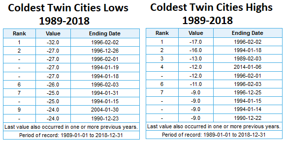
For the Twin Cities, here’s a look at the coldest highs and lows over the past 30 full years of data (1989-2018). With Wednesday’s forecast high of -13F, it would be the coldest since February 2, 1996, when the thermometer struggled to reach -17F. Our forecast lows could also be the coldest since 1996 if we get down to that low of -25F Wednesday morning. Only a couple dates from the 21st centrury make these lists: a low of -24F on January 30, 2014 tied for the ninth coldest low in the past 30 years, and a high of -12F on January 6, 2014 tied for the fourth coldest high in the past 30 years.
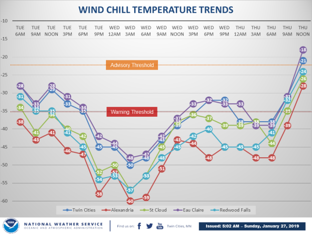
It won’t only be the actual temperature that will be dangerous – once you factor in the wind it’ll feel even worse. The coldest wind chills are expected Wednesday morning when even here in the Twin Cities we could see a wind chill value near -50F. Other parts of the state could see wind chill values approach -60F.
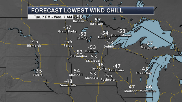

Meanwhile, here are the expected morning wind chill values for Wednesday and Thursday morning across the state. Again, the coldest morning is expected to be Wednesday morning, when some areas of the state could see wind chill values approach -60F.
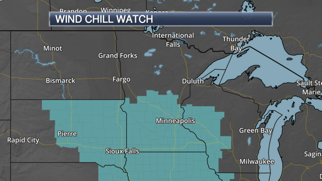
Due to these dangerous forecasted wind chills, Wind Chill Watches have already been posted for Tuesday through Thursday morning across parts of central and southern Minnesota.
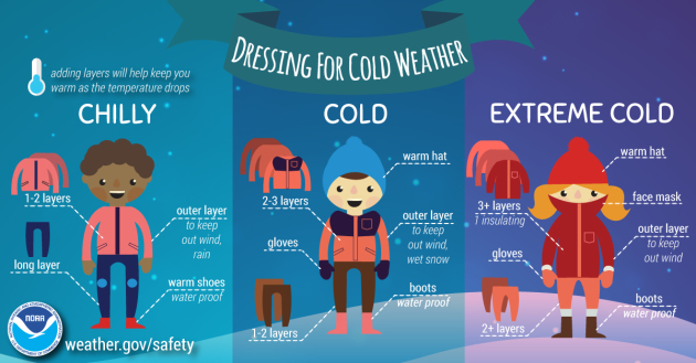
So what should you do to prepare for the cold weather? And what should you do during and after this arctic smackdown? The National Weather Service has a bunch of tips – I have a sample of what you should do before the cold weather below from their list, but click here for all the details.
- Adjust Your Schedule: If possible, adjust your schedule to avoid being outside during the coldest part of the day, typically the early morning. Try to find a warm spot for your children while waiting for the school bus outside.
- Protect Your Pets, Livestock and other Property: If you have pets or farm animals, make sure they have plenty of food and water, and are not overly exposed to extreme cold. Take precautions to ensure your water pipes do not freeze. Know the temperature thresholds of your plants and crops.
- Fill up the tank: Make sure your car or vehicle has at least a half a tank of gas during extreme cold situations so that you can stay warm if you become stranded.
- Update Your Winter Car Survival Kit
_______________________________________________
Record Lows Broken Sunday Morning
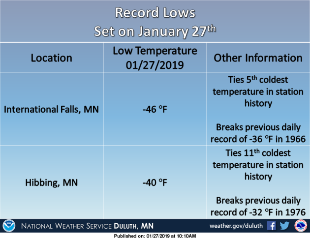
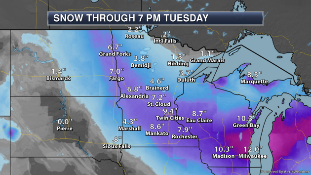
Of course, Minnesota has still been cold the past several days. This morning, however, saw a couple records broken across northern Minnesota at International Falls and Hibbing. The low at International Falls was -46F, tied for their fifth coldest low on record
_______________________________________________
National Weather Forecast

The clipper system responsible for heavy snow in the upper Midwest will continue to move east, bringing snow to the Great Lakes and parts of the Northeast with rain likely in the Ohio Valley to the Deep South. After the frontal passage, however, this rain could change over to snow in these areas, especially into Monday Night. Some snow will be possible across the Rockies.
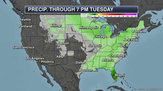
The area getting soaked the most with precipitation through Tuesday will be central and southern Florida, with rainfall tallies approaching three inches in spots.
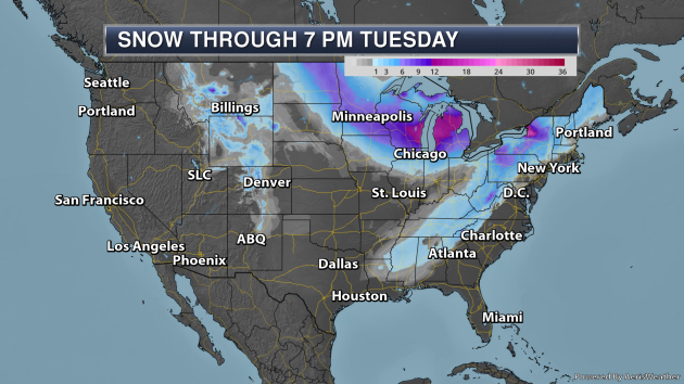
Meanwhile, the heaviest snow will fall north of the low pressure center associated with the clipper, with the potential of over a foot of snow in parts of Wisconsin and Michigan. Heavy lake effect snow will also be possible, especially downwind of Lake Ontario through Sunday Night. You may also notice snow sneaking into the Southeast. As mentioned above, after the cold front passes Monday Night into Tuesday, some snow could fall. Right now totals of 1-2″ will be possible into parts of Louisiana, Mississippi, Alabama, and northern Georgia. I’ll have more on both the clipper and Southeast snow below.
_______________________________________________
Praedictix Corporate Weather Briefing: Sunday morning, January 27th, 2019
- A clipper system is dropping south out of Canada today, bringing a heavy band of snow with it along its path across the upper Midwest and Great Lakes over the next couple days.
- A band of at least 6” of snow is expected to fall across parts of the Dakotas eastward into the Great Lakes. The heaviest totals (potentially over a foot) will be possible across east-central Wisconsin into west-central and northern Michigan.
- Strong winds are also expected, especially behind the system as an arctic front moves through. This will cause the potential of blizzard conditions across portions of the Dakotas tonight into Monday morning.
- Behind the snow dangerously cold air will move into the upper Midwest for the middle of the week. The coldest day is expected to be Wednesday, when areas from Minnesota to Chicago may not make it out of the teens below zero for highs. That’ll be after parts of Minnesota wake up to wind chills as low as -60F.

Sunday Morning Radar. Snow associated with a clipper system is already dropping south out of Canada into parts of the Dakotas this morning. Snow has already been reported in Bismarck, Minot, and Yankton.

Tracking Upper Midwest Snow. Snow will continue to quickly spread south and east throughout the day, reaching the Twin Cities during the mid-afternoon hours and into Michigan overnight. This system will likely bring snowfall rates of at least 1 inch per hour in the heaviest bands as it moves across the upper Midwest and Great Lakes. Gusty winds will also cause blowing snow and behind the system could cause blizzard conditions in parts of the Dakotas.

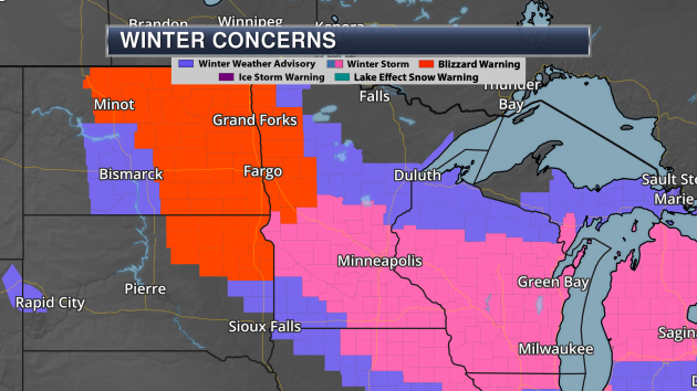
Winter Weather Alerts. Due to the potential of heavy snow over the next couple days, Winter Storm Warnings have been issued from eastern North Dakota into Michigan. Meanwhile, Blizzard Warnings have been issued from central North Dakota to northeastern South Dakota for the potential of snow and/or mixed precipitation as well as blizzard conditions (nearly constant sustained winds of at least 35 mph with visibility being reduced to a quarter mile or less due to blowing snow for at least three consecutive hours). Some of the locations under winter weather alerts this morning include:
- Minot, ND: Winter Weather Advisory from 9 AM to 6 PM today, followed by a Blizzard Warning from 6 PM tonight to Noon Monday. This is in effect for 3-6″ of snow today followed by a ground blizzard tonight into Monday with wind gusts up to 60 mph.
- Fargo & Grand Forks, ND: Winter Storm Warning from Noon today to Noon Monday for 5-7″ of snow and wind gusts as high as 35 mph.
- Aberdeen, SD: Winter Weather Advisory from 9 AM to 9 PM today, followed by a Blizzard Warning from 9 PM tonight to Noon Monday. This is in effect for 1-4″ of snow as well as a light glaze of ice mainly before 9 PM tonight followed by blizzard conditions with wind gusts up to 60 mph.
- Minneapolis, MN: Winter Storm Warning from 3 PM today to 3 PM Monday for 6-8” of snow.
- Waterloo, IA: Winter Storm Warning from 3 PM today to Noon Monday for 3-6” of snow. Blowing and drifting snow possible.
- Wausau, WI: Winter Storm Warning from 6 PM tonight to 6 PM Monday for 6-12″ of snow.
- Milwaukee, WI: Winter Storm Warning from 9 PM Sunday to 6 PM Monday for 7-13” of snow.
- Chicago, IL: Winter Weather Advisory from 9 PM tonight to 6 PM Monday for 3-6″ of snow with a light glaze of ice. Patchy blowing snow possible.
- Grand Rapids, MI: Winter Storm Warning from 1 AM Monday to 7 PM Monday for 8-12″ of snow.
- Detroit, MI: Winter Weather Advisory from 7 AM Monday to Midnight Monday Night for 3-5″ of snow.

Expected Snow Through Tuesday Evening. A band of at least 6” of snow will fall from the Dakotas eastward into the Great Lakes as this system moves through the region over the next couple days. The heaviest snow will fall from east-central Wisconsin into west-central and northern Michigan, where snow totals over a foot will be possible. This snow will have travel impacts to end the weekend and begin the new work week.

Potential Wind Gusts. Strong winds are expected to filter into the region as an arctic front moves through later today into tonight, creating the potential of blizzard conditions across parts of the Dakotas. Strong winds won’t be limited to areas that receive heavy snow, however, as wind gusts could approach 70 mph in parts of western and central North Dakota, western South Dakota, and northeastern Montana that see only up to a couple inches of snow.

High Wind Warnings. Due to the potential of very strong wind gusts with this system, High Wind Warnings are in place from Montana to the Sioux City, IA, area. These areas are most likely to see the potential of 50-70 mph later today into Monday. These winds could cause power outages and knock down trees and tree limbs.

Dangerously Cold Air Follows Behind The Snow. A blast of dangerously cold air is still expected to follow this snowstorm across parts of the upper Midwest. Above are expected highs and lows for Tuesday through Thursday across the North Central United States. Areas like the Twin Cities will have the potential to see at least a three day stretch of below zero weather, and even Chicago won’t make it above zero on what is expected to be the coldest day of this arctic outbreak Wednesday. This will be some of the coldest air in several years for many locations. For example, the Twin Cities hasn’t seen a high of -15F or colder since February 2nd, 1996.


Wind Chill Values. Extremely cold and dangerous wind chill values are also expected with this stretch of bitterly cold weather. The worst morning will be Wednesday, as winds of 10-20 mph will make it feel more like -40F to -60F across parts of the upper Midwest. It won’t feel much better during the day either, with wind chill values of at least -30F to -45F expected in some areas, which will last into Thursday morning as well. These wind chills would cause frostbite in less than 5-10 minutes.

Wind Chill Watches. Due to this extended dangerous stretch of cold weather, Wind Chill Watches have already been issued for parts of Minnesota, South Dakota, Nebraska, Iowa, and Wisconsin starting Tuesday and lasting through Thursday morning. I would expect additional Wind Chill Watches to be issued across parts of the upper Midwest, with these eventually being upgraded into Wind Chill Warnings (that would be likely to occur sometime Monday).

Snow In The Southeast. This same system will bring the potential of snow to parts of the Southeast Monday Night into Tuesday as the front swings south and temperatures fall to near or below freezing behind it. The current forecast has the potential of 1-2″ of snow stretching from parts of Louisiana back into Tennessee. This snow could cause travel issues in the region.
D.J. Kayser, Meteorologist, Praedictix
_______________________________________________
Drought turns part of Iran into a new dust bowl
More From National Geographic: “In southeastern Iran, summers have never been for the faint-hearted. The temperature routinely tops 110 F (43.3 C). There isn’t a hint of rain. When, every May, a vicious, hair dryer-like wind, known as the Wind of 120 Days, begins to whip in across the semi-arid flatlands, the entire area wanes under a months-long barrage of sand, cloying dust, and noise. American soldiers across the border in neighboring Afghanistan are warned to be particularly wary when these gusts pick up. “High winds can turn tent pegs and loose objects into flying missiles (which may not be visible in blowing sand),” cautions “A Soldier’s Guide to Staying Healthy in Afghanistan and Pakistan,” a U.S. army medical manual. Locals are sometimes forced to shout at one another just to make themselves heard amid the breathless whistling.”
Australia’s Heat Wave Is Taking A Toll On People, Animals, Infrastructure And Land
More from NPR: “It’s summertime in Australia, and the country is in the throes of a record-breaking heat wave that has brought suffering to humans, animals and land.Temperatures in the south have soared past 118 degrees Fahrenheit.Australia’s State Emergency Service declared the heat wave a threat to public safety, as an increasing number of Australians have called ambulances and gone to hospitals in Adelaide for heat-associated illnesses.The Australian Energy Market Operator cut power to 200,000 people in the southern state of Victoria after demand increased for air-conditioning.”
How Australia’s Deadliest Fires Made Thousands of Students Fall Behind
More from Earther: “Natural disasters come in all many forms, from hurricanes to wildfires. They all have something in common, though: They ruin people’s lives. And the effects can linger years after the event has passed, especially for elementary school children whose education has only just started, according to a new study. Published in the Child Development journal Thursday, the study tracked 24,642 Australian children who attended primary schools in the state of Victoria and felt the impacts from the Black Saturday wildfires in 2009. These fires were among the worst the country has seen: 173 people died, thousands of structures burned, and more than 988,000 acres were torched, according to the Country Fire Authority. This new study found that kids’ academic progression suffered roughly a 5 to 6 percent loss as a result of the traumatic event.”
_______________________________________________
Thanks for checking in and have a great Monday! Don’t forget to follow me on Twitter (@dkayserwx) and like me on Facebook (Meteorologist D.J. Kayser)!
– D.J. Kayser
