
National Weather Forecast
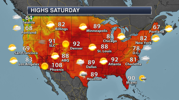
While Florence will continue to impact the Mid-Atlantic Saturday, there are a few other stories across the nation. Another system that we had been tracking across the Gulf has moved inland across Texas, bringing heavy rain along with it. A semi-stalled system across parts of the upper Midwest could spark off a few showers and storms at times. A trough of low pressure approaching the Pacific Northwest could bring rain to areas like Seattle and Portland.
Two areas of very heavy rain are possible through Wednesday morning across the nation. One is across the Mid-Atlantic and Northeast, courtesy of Florence. The other is across Texas due to that system which move inland.
_______________________________________________
Florence Makes Landfall
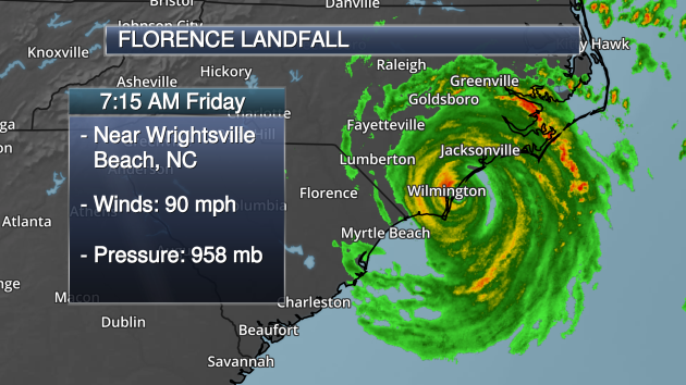
Hurricane Florence made landfall Friday morning at 7:15 AM ET as a Category 1 hurricane with 90 mph winds. Florence made landfall near Wrightsville Beach, NC. Around the same time, a wind gust of 105 mph was recorded in Wilmington.
Here’s a loop of Florence as the system was making landfall Friday morning across North Carolina. There is more on Florence below.
_______________________________________________

Praedictix Corporate Weather Briefing Excerpt: Friday morning, September 14th, 2018
Written by D.J. Kayser, Meteorologist, Praedictix
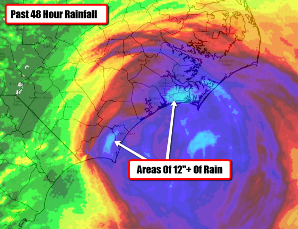
Rainfall So Far. Radar indicates that over a foot of rain has fallen so far in association with Florence in parts of coastal North Carolina. This heavy rain is leading to flash flooding across the region. Top rainfall totals through 4 AM in North Carolina include:
- 10.89” – Sneads Ferry
- 10.30” – Wrightsville Beach
- 10.10” – Oriental Town Pier
- 8.79” – Cedar Island Ferry Terminal
- 8.70” – Surf City
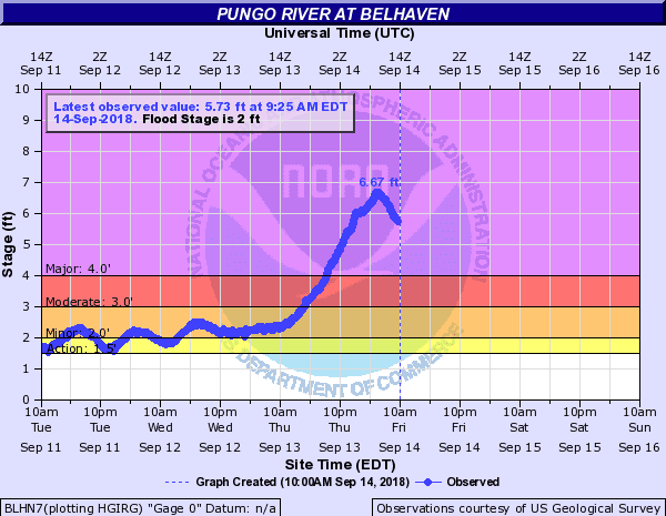
Storm Surge Flooding. Major storm surge flooding is also occurring along the coast and inland rivers due to Florence, with the Pungo River reaching a height overnight of 6.67 feet. As the Neuse and Trent rivers rose last night in the New Bern area at least 200 people had to be rescued. Additional storm surge flooding is likely across the region later today, especially around the next high tide early this afternoon.

Flash Flood Warnings And Emergencies. Due to the very heavy rain across the region so far in association with Florence, numerous Flash Flood Warnings have been issued. Due to heavy rain of 8-12” and storm surge flooding, a Flash Flood Emergency has been issued for parts of Carteret, Craven, Pamlico, and Jones Counties in North Carolina until 1 PM. That warning states that additional rainfall amounts of 3-6” are possible.

Peak Wind Gusts. Several wind gusts of at least 90+ mph have been reported mainly across North Carolina so far in association with Florence. Here is a list of top wind gusts so far:
- 112 mph: A buoy 30 miles southeast of New River Inlet
- 105 mph: Wilmington, NC, and Fort Macon, NC
- 97 mph: Cape Lookout, NC
- 89 mph: Near Cedar Island, NC
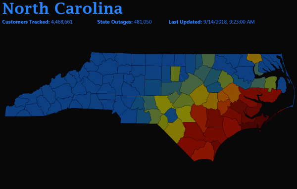
Power Outages. Due to the high winds and flooding, numerous power outages are being reported across parts of the Carolinas. As of 10:20 AM ET, over 481,000 customers in North Carolina and over 37,000 customers across South Carolina had no power. The hardest hit areas have been in western parts of North Carolina and in northeastern parts of South Carolina. You can view this map and links to local power companies at poweroutage.us.
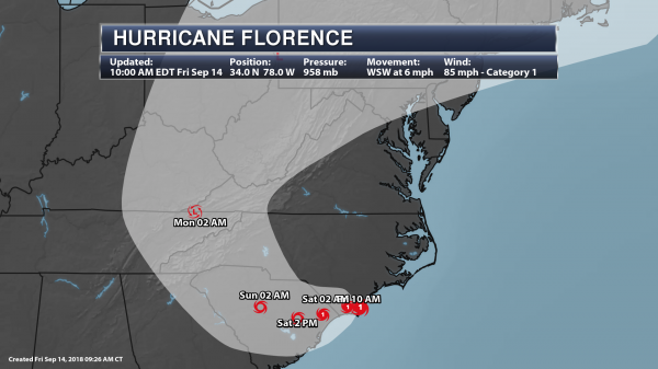
Forecast Track. Florence will slowly move west to west-southwest over through Saturday, continuing to lash portions of North and South Carolina over the next several days. Later in the weekend, Florence will start to move north across the western Carolinas and into the central Appalachian Mountains into next week. Florence will continue to weaken as this storm moves inland throughout the next several days, becoming a tropical depression by Monday morning.
_______________________________________________
Two of Colorado’s largest trees burn in 416 Fire
More from the Durango Herald: “Two of the largest trees in the state of Colorado fell victim to the flames of the 416 Fire, a flyover of the burn scar revealed last week. Since the outbreak of the 416 Fire in June, forest researchers have wondered whether the record-setting trees in the Hermosa Creek drainage survived, said Gretchen Fitzgerald, a forester for the U.S. Forest Service. “We had some hope,” Fitzgerald said Tuesday. The Hermosa Creek drainage, about 20 miles north of Durango, is considered a prime spot for big trees to grow because of the combination of fertile soil, moist air and protection from severe weather patterns, Fitzgerald said.”
North Carolina’s Natural Hurricane Defenses Are Disappearing
More from Scientific American: “The Outer Banks, and other barrier islands along the North and South Carolina shorelines, may see some of their worst storm-related damage in years as Florence approaches the coast, experts say, due to a combination of high winds and catastrophic storm surge. In fact, these islands are doing what they’re naturally made to do—buffer the inland shore against the impact of major storms. But scientists are worried that the barrier islands, some of the East Coast’s most important natural defenses, may be in serious jeopardy. The influence of human development on the islands, combined with the relentless progression of sea-level rise, is threatening to sweep them away. If so, storms like Florence could have an even bigger impact on the Carolina coastline in decades to come.”
Emissions Have Already Peaked In 27 Cities – And Keep Falling
More from WIRED: “Cities are also now serving as a unique testbed for responses to climate change—bolstering public transportation, erecting more efficient buildings, deploying renewable energy. Instigating those projects is the mission of C40, a coalition of international cities working to cut down on greenhouse gas emissions, no matter what their own national governments may be up to. Today, as politicians, business leaders, and activists gather for the Global Climate Action Summit, in San Francisco, C40 is announcing that 27 cities—including New York, London, and Rome—have reached a peak in emissions, and have seen at least a 10 percent drop from their peak. That’s a big deal in the fight against climate change. But how do you go about measuring the emissions of an entire city? Sadly, it’s not about putting scientists in balloons and floating them over a metropolis to take readings. Instead, cities report several metrics to C40. For example, you’d look at how much energy buildings are using. You’d also consider how much fuel the citizens are buying. Transport is a big one too—so rail and, if you’re on a river or the coast, water transportation.”
_______________________________________________
Thanks for checking in and have a great Saturday! Don’t forget to follow me on Twitter (@dkayserwx) and like me on Facebook (Meteorologist D.J. Kayser)!
– D.J. Kayser
