

I Have Good News And I Have Bad News
Is the weather-glass half full or half empty? Depends on who you ask. Snow lovers are feeling blue, although it’s been consistently cold enough for ski resorts to be making snow.
Cold, crystalline water is a big part of our identity in Minnesota. Brown (green) lawns are disorienting in early December, but at least the odds of fender-benders goes way down.
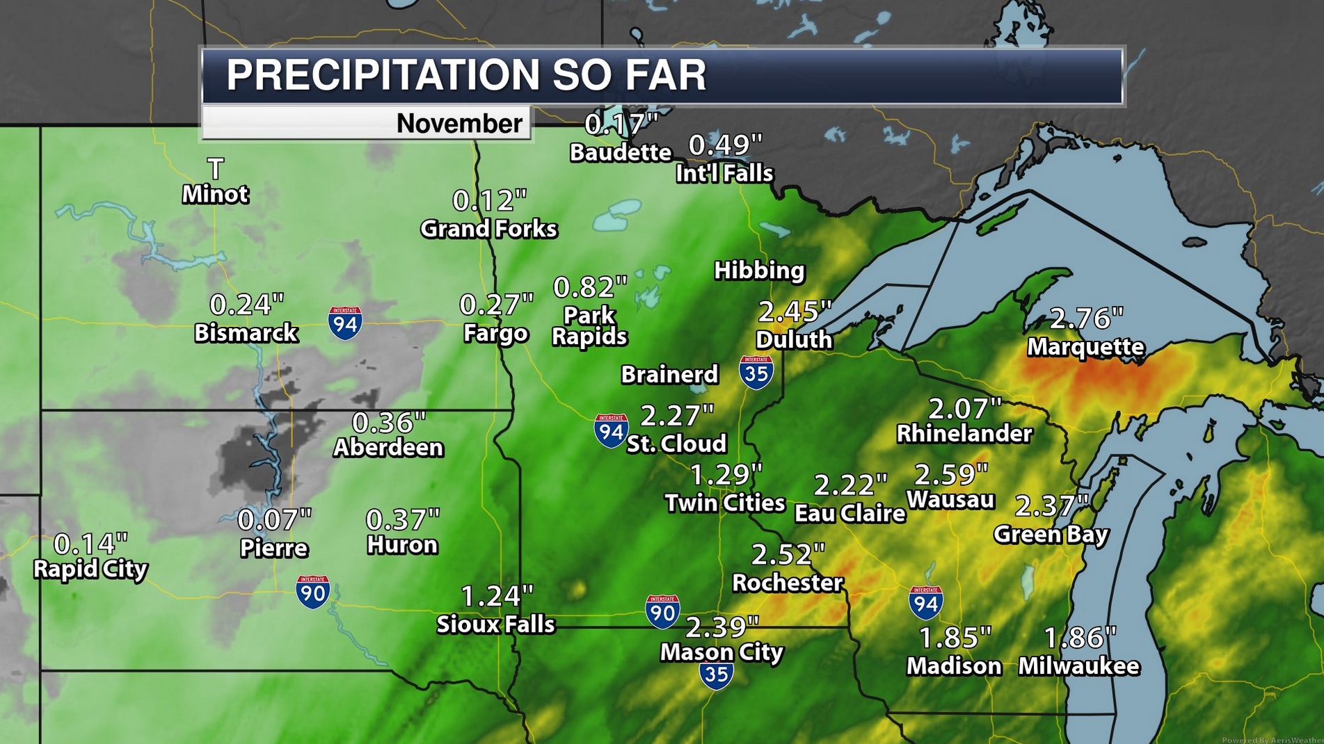
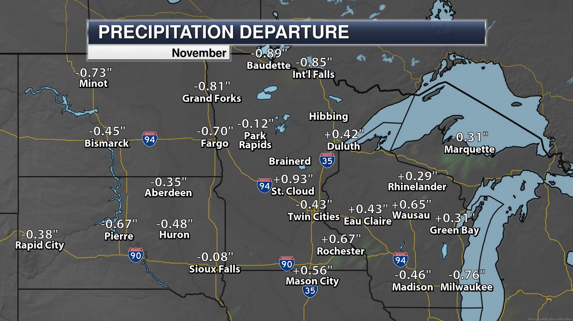
November is the cloudiest month of the year, but a third of the days last month were sunny. My friend, Mark Seely, tells me that November may rank among the 7 warmest years, statewide, since 1895. Less money on heating bills. Yes, it’s a mixed blessing.
What’s going on here Paul? If you’re feeling snow-remorse blame the shape of the jet stream. Our biggest storms arrive when steering winds are blowing from New Mexico, pushing moisture north. Until further notice, winds aloft blow from the Pacific; a relatively mild & dry pattern forecast to spill into much of December. Expect a string of 40s from Wednesday into next week.
One odd winter indeed.
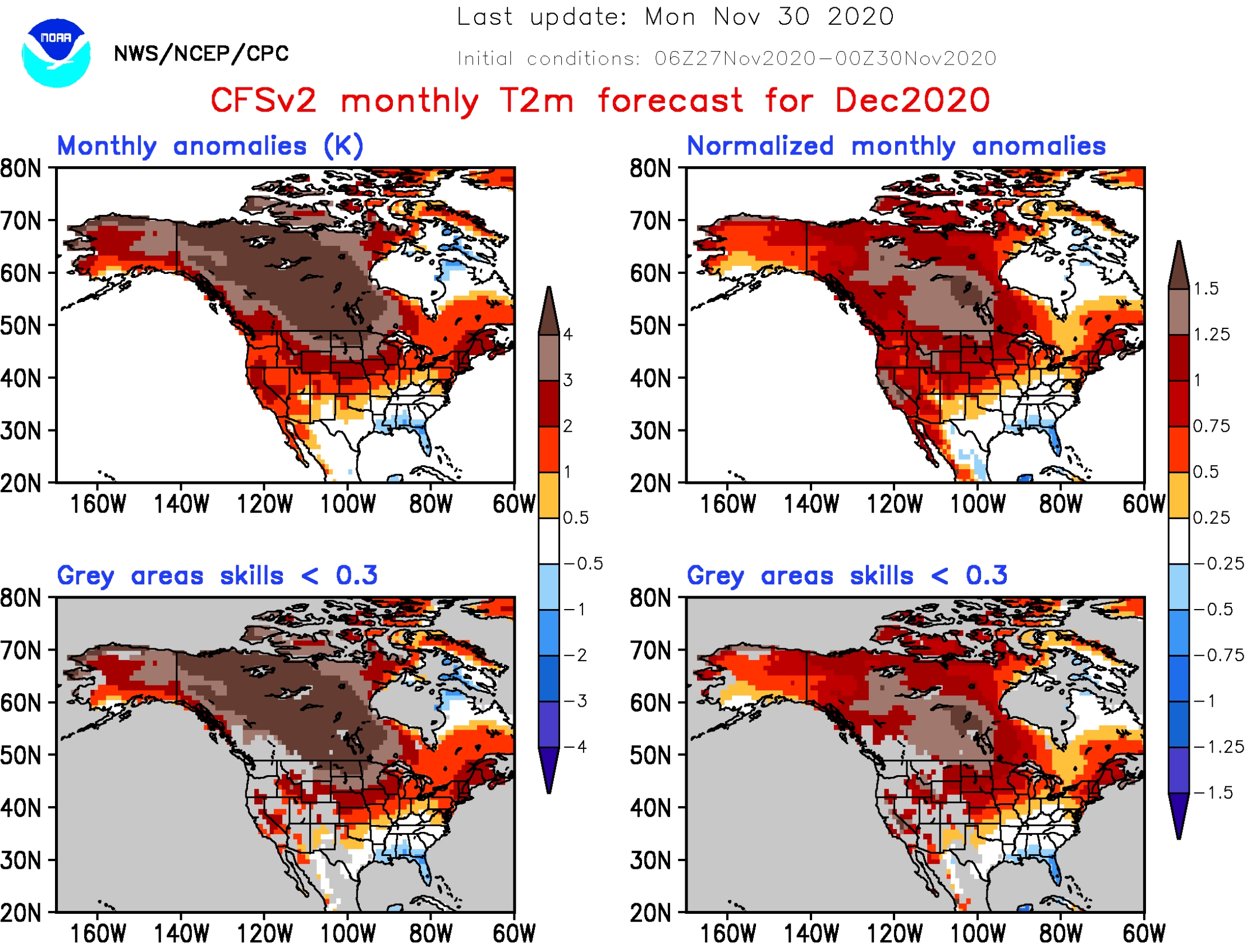
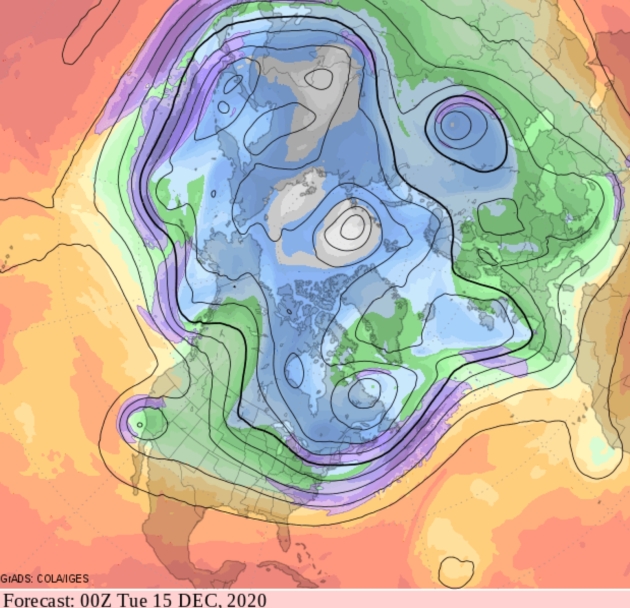
December Temperature Anomalies. 4-8F warmer than average this month? That’s what NOAA’s Climate Forecast System version 2 is (consistently) predicting for December across Minnesota, with eye-opening anomalies over 10F for much of Canada. To which I reply, what La Nina? Map credit: NOAA.

Top 7 Warmest Minnesota November on Record? That’s the latest, based on data compiled by Dr. Mark Seeley; here’s an excerpt from Minnesota WeatherTalk: “In contrast to October, this November was very much warmer than normal. Most climate stations report an average monthly temperature that ranges from 4 to 6°F above normal. This means that November of 2020 will likely rank among the top 7 warmest in Minnesota history back to 1895. The week of November 3-9 was the warmest week in November history here. Within the state climate observation network over 200 daily record maximum temperatures were recorded, along with over 120 record warm daily minimum temperatures. For the first time in history Minnesota recorded 4 days during November when the daily maximum temperature reached 80°F or greater…”
Photo credit: Paul Douglas.
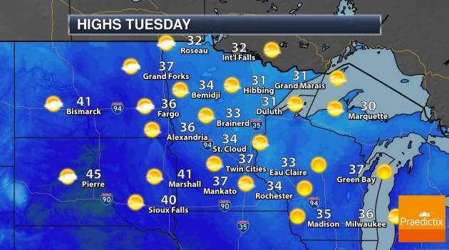
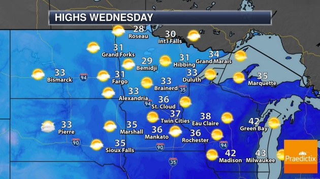
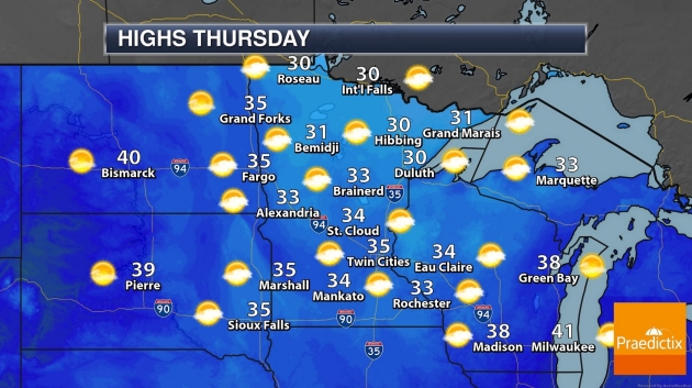

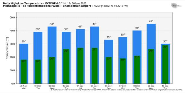
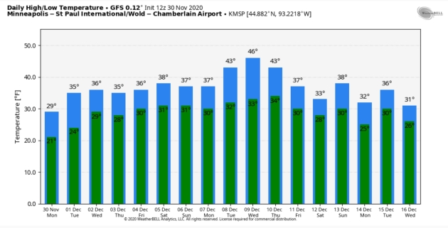
Mid-December: Still Modifed Zonal. We’ll see cold frontal passages (take it to the bank) but the overall flow is more Pacific than Arctic, so brief cold spells will be followed by (longer) milder periods with 40s returning.
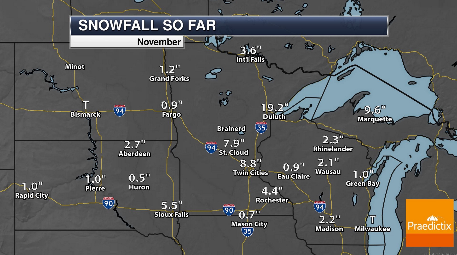
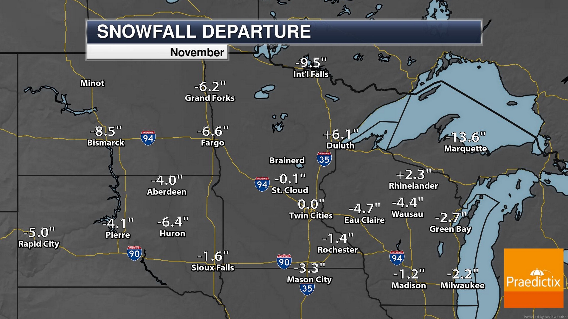
A Perfectly Average November Snowfall for MSP. 8.8″ of snow earlier this month (remember) and then nothing the latter half of the month still adds up to normal 30-year November snowfall for the Twin Cities. A whopping 19.2″ was 6.1″ snowier than normal for Duluth. Map credit: Praedictix and AerisWeather.

Praedictix Briefing: Issued Monday, November 30th, 2020:

Heavy Snow On The Way. As low pressure develops and moves across the eastern United States today into Tuesday, heavy rain will be possible from the Deep South to the Northeast coast, with heavy accumulating snow possible from the Appalachians to the Ohio Valley and Northeast. For areas like Cleveland, rain is occurring today and expected to change to snow tonight, lasting into Tuesday with the heaviest snow expected tomorrow.
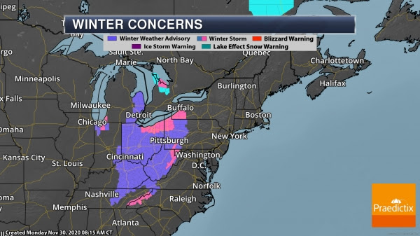
Winter Storm Concerns. Numerous Winter Storm Warnings and Winter Weather Advisories stretch from the Appalachians to the eastern Great Lakes, ahead of the potential of heavy snow across the region. This includes the following locations:
- Gatlinburg, TN: Winter Storm Warning though Noon Tuesday for 2-4” of snow.
- Cleveland, OH: Winter Storm Warning from 7 PM tonight to 10 AM Wednesday for 8-12” of snow with winds to 35 mph.
- Charleston, WV: Winter Weather Advisory from 8 PM tonight to 7 PM Tuesday for 2-4” of snow.
- Lexington, KY: Winter Weather Advisory from 4 PM today through 7 AM Tuesday for 1-2” of snow.
- Cincinnati, OH: Winter Weather Advisory through 7 AM Tuesday for 1-3” of snow.
- Columbus, OH: Winter Weather Advisory from Noon today to Noon Tuesday for 2-4” of snow.
- Erie, PA: Winter Weather Advisory from 1 AM Tuesday to 4 PM Wednesday for 3-6” of snow with winds to 35 mph.
- Detroit, MI: Winter Weather Advisory from 3 PM today to Noon Tuesday for 2-3” of snow.


Expected Snow. The heaviest snow is expected south of Lake Erie over the next few days, particularly in the higher terrain east of Cleveland into northwestern Pennsylvania, where snow totals of 12-18″ will be possible. This will make travel very difficult across the region. In Cleveland, up to an inch or two of snow will be possible tonight, with 4-10” possible Tuesday, and another 1-3” possible Tuesday Night.
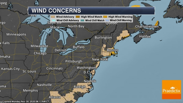

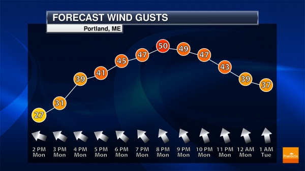
Strong Winds In The Eastern U.S. This system will also produce strong winds across portions of the eastern United States. Portions of Rhode Island, eastern Massachusetts, and Maine are under High Wind Warnings today into Tuesday due to wind gusts up to 60 mph. Boston is under a Wind Advisory from 3 PM today to 1 AM Tuesday for wind gusts up to 50 mph. In Portland, a Wind Advisory is in place from 4 PM this afternoon to 1 AM Tuesday, also for wind gusts to 50 mph.
D.J. Kayser, Meteorologist, Praedictix.
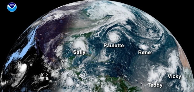
Record-Shattering 2020 Hurricane Season Officially Comes to an End. USA TODAY has a good recap of an extraordinary year: “It’s officially over. After six long months and 30 storms from Arthur to Iota, the record-shattering 2020 Atlantic hurricane season ends Monday. “I didn’t think I would live to see that, but it’s happened,” Penn State University meteorologist Michael Mann told USA TODAY, referring to the record number of named storms in a single season. A typical season sees only 12 storms. All preseason forecasts said an active season was likely, but none came close to the actual number. “Our group here at Penn State predicted an unusually active season, as many as 24 named storms – the most of any of the preseason predictions,” Mann said. “But even THIS wasn’t aggressive enough a forecast...”
File image credit: NOAA.
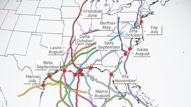
A Very Rough Hurricane Year for Coastal U.S. Residents. CNN.com has a good recap. It’s over now, right? Here’s the intro: “People along nearly every mile of coastline from Texas to Maine have been put on alert this Atlantic hurricane season, as 12 of 29 storms made landfall in the United States in this record-setting year. “Every mile of the US Gulf and Atlantic coast has been under a Tropical Storm or Hurricane Watch or Warning, except for one single county with coastline: Wakulla County, Florida,” said Jake Carstens, meteorology graduate research assistant at Florida State University…”So far this year, 3598 of 3613 miles (99.6%) have been warned,” tweeted James Franklin, the former chief of the Hurricane Specialist Unit at the National Hurricane Center...”
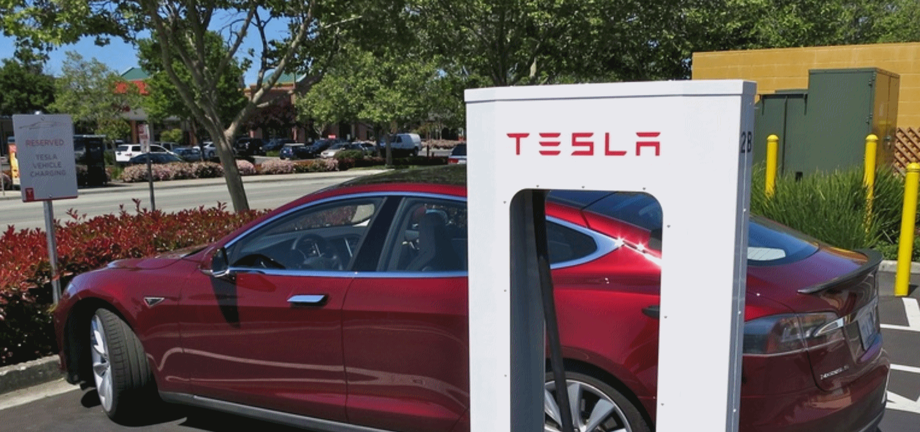
Most Americans Won’t Buy an Electric Car Unless They Get The “Gas Station Experience”. We will transition from gas stations to service stations, with a mix of gas and electric options. Wait for it. Here’s an excerpt from The Mobilist: “…Calise, the executive from Tritium, said the build-out should begin like the Eisenhower-era highway system, with the construction of EV charging corridors. These would involve the construction of EV charging stations every 10 miles or so along the country’s main highways. From there, spokes can be filled in where people live and work, especially inner cities. The problem is that they are expensive, requiring the government to get behind them, Calise said. President-elect Joe Biden is proposing that the federal government subsidize the construction of 500,000 charging stations. If Congress approves funding, charging will be accelerated. “You will start to see them at all the gas stations, convenience stores, hotels, ports, stadiums, fleet depots,” Calise said. “The pure gas station is going to be disrupted…”

Goldman Sach Bankers Using Drones to Inspect Potential Acquisitions. CNBC.com has an intriguing post; here’s an excerpt: “…After Covid-19 made the prospect of hosting in-person visits with groups of bidders unsafe, commercial-grade drones have been used to conduct virtual tours of everything from shipping ports and railroads to chemical factories, warehouses and big-box retail locations, he said. “We have been selling asset-based businesses all over the world using drones for site visits and fly-overs,” Feldgoise said in a phone interview. “It gives buyers the confidence they need because when you are buying a business, you want to see, touch and feel what you are buying... ”

Sports Has a Gen Z Problem. The Pandemic May Accelerate It. How many games are you willing to consume on your phone. The Washington Post (paywall) reports: “…The bulky and bankable U.S. sports industry, built on towers of cash and lucrative television contracts, is confronting a Generation Z problem. The nation’s youngest cohort is fundamentally different from the generations that preceded it. Having grown up with smartphones in their pockets, its members eschew traditional television viewing and subscribe to digital habits that make grooming a new generation of sports fans a challenge. That challenge is being met with a sense of urgency in some corners of the sports world and a sense of alarm in others, according to team and league officials, social scientists, research analysts and marketing specialists who focus on Generation Z. Failing to hook young people might not devastate today’s bottom line, but it threatens to muddle the future of every league, every team and every sport…”
Illustration credit: “Sports executives are confronting a Gen Z problem that the pandemic may make worse.” (Anuj Shrestha for The Washington Post).
Why Stress-Baking and Cleaning Make You Less Anxious. It’s all about wellness and the ability to disconnect, says a writer at WIRED.com (paywall). Here’s a clip: “…But these are more than desperate attempts at self-soothing. It turns out that homekeeping and self-care activities like meditating, cooking, cleaning, and even just stocking the pantry can help stop cycles of anxiety and depression by changing how the human brain self-regulates. Here’s why stress-baking or cleaning feels so good, neurologically speaking. When humans perceive a threat or stressor, our amygdala—a small region of the brain associated with facilitating fear, anxiety, and emotion—jumps into gear and becomes more active. This activation can have physical consequences, too. Sometimes people who are anxious report feeling short of breath or have an increased heart rate. That’s because the amygdala is also involved in regulating our blood pressure, breathing, and heart. So when the amygdala gets going, those systems do too…”

How is the Fast Food Industry Surviving Coranavirus? It’s a mixed blessing, but some chains are doing very well during this extended quarantine. Quartz reports: “The coronavirus pandemic has changed our relationship with fast food. Recent financial disclosures and earnings calls from some of the world’s largest quick-service restaurant companies give us a detailed idea of how they are adapting as a result. Quick, convenient, low-contact meals from fast-food chains have helped many people through the pandemic. Drive-through business has boomed as people avoid going indoors and try to keep their distance. Many in the industry have focused on maximizing contact-free experiences like delivery and curbside pickup…”
29 F. high in the Twin Cities on Monday.
33 F. average high on November 30.
34 F. MSP high on November 30, 2019.
December 1, 1998: The warmest December day ever in the Twin Cities is recorded, with a high of 68 degrees. St. Cloud rose to 61.
December 1, 1985: Parts of central Minnesota receive up to a foot of snow. Snowfall totals include 12 inches at Waseca and Milaca, 11.3 at Alexandria, and 11 inches at Fairmont and Long Prairie.


TUESDAY: Bright sunshine. Winds; SE 5-10. High: 38
WEDNESDAY: Sunny, a bit milder. Winds: NW 5-10. Wake-up: 23. High: 42
THURSDAY: Plenty of sunshine. Winds: W 7-12. Wake-up: 26. High: 39
FRIDAY: Blue sky, amazingly quiet. Winds: NW 7-12. Wake-up: 28. High: 41
SATURDAY: Generous sunshine, breezy. Winds: NW 10-15. Wake-up: 29. High: 43
SUNDAY: Mostly cloudy, feels like December. Winds: NW 10-20. Wake-up: 29. High: 32
MONDAY: Clouds increase, late rain/snow shower. Winds: SW 8-13. Wake-up: 19. High: 36