
We got not just one, but two relatively strong areas of low pressure this week. They will each drag a cold front and bring rounds of heavy rain, potential flooding and strong-to-severe thunderstorms. Severe Storm triple threat Tuesday, Wednesday and Thursday. All severe storms components are in play because of this: very large hail, damaging winds, and tornadoes.
The MARGINAL RISK of severe storms for today (Tuesday, March 23rd) includes: St. Louis, Mobile, and New Orleans. The lowest level of your home and inner-most room is preferred because you want to put as much ‘stuff’ as in walls between you and the outside. Avoid mobile homes and vehicles because they offer little-to-no severe storm safety.
Walking through the Severe Storm triple threat Tuesday, Wednesday and Thursday.
Wednesday

Severe Storm Risk for Wednesday, March 24th. Source: SPC.
Isolated severe thunderstorms are possible over a portion of the lower Mississippi Valley and also the southern Plains. Timing is Wednesday evening and into the overnight because the next front moves in. The severe storm triple threat Tuesday, Wednesday and Thursday marches on.
Thursday

Severe Storm Risk for Thursday, March 25th. Source: SPC.
A potential outbreak of severe storms including strong tornadoes, large hail and damaging wind will exist Thursday afternoon into the overnight across a portion of the lower Mississippi Valley and Southeast States. This is because a relatively strong area of low pressure will swing a cold front into an unstable airmass, full of moisture and spin-with-height in the atmosphere.
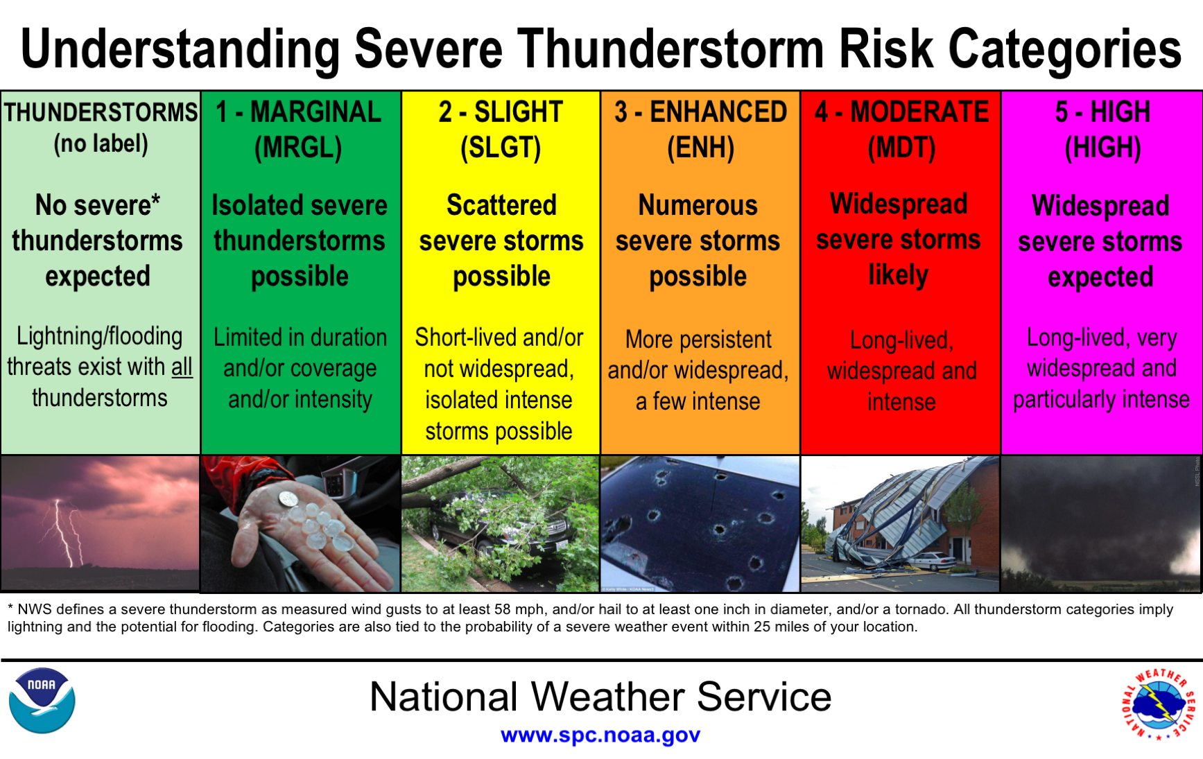
Understanding severe storm risks from the SPC.
Flooding Potential
Current Watches and Precipitation Forecast

FLASH FLOOD WATCHES (dark green) as of 7:00 AM CDT

Rainfall forecast through 7:00 PM CDT Thursday
Heavy rains are possible over the next two days along portions of the central Gulf coast because of multiple slow-moving storms. So flash Flood potential exists for: eastern Louisiana, southern Mississippi and southern Alabama. Total rainfall of 6 to 8+ inches are possible.
Flood Safety

Flood safety. Flash flood safety. Source: NOAA
Who is Praedictix? We are a weather company that focuses on delivering credible weather forecasts to our clients. We have three main offerings: media, weather graphics, and weather consulting.
Media: With two HD studios, we’re able to create professional weather forecast videos for use in television, social media, apps, and websites. Our forecasts are tailored to our clients’ brand. Our content ranges from national to hyperlocal forecasts and air all over the country.
Weather Graphics: We have access to a robust weather dataset which allows us to create high customizable, HD weather maps and graphics for use in television, digital signage, social media, and websites. Our white-label graphics allow our clients to push their own brands and sponsors.
Consulting: We lend our weather expertise to our clients to help with risk mitigation and business optimization by way of conference calls, emails, and briefings. We also have a forensic meteorology team that specializes in forensic weather analysis and expert testimony.
Click right HERE to learn more about us or contact us for your weather needs.

Joe Hansel
Lead Morning Meteorologist