
It is severe weather awareness week here at Praedictix. Over the next few days, we will walk you through relevant information on what to look out for in the event severe weather strikes. This is because severe weather impacts hundreds-to-thousands of lives, property and wallets every single year. Let’s dive in to help you be weather aware. Prepare and be proactive now, so you do not find yourself being reactive later. Today’s topic: Reading basics of severe outlook maps. What are the risks and what do they mean?
What do the maps look like?

You see maps like these in weather forecasts. Maybe you hear terms ‘marginal risk’ or ‘high risk’.
This is our severe weather potential map for Friday. We follow the forrmat of the Storm Prediction Center for consistancy. You see colors and polygons that list: General, Marginal, and Slight. How do you translate this information? How do you use this severe storm potential to help plan your day?
Matching The Colors with the Risk
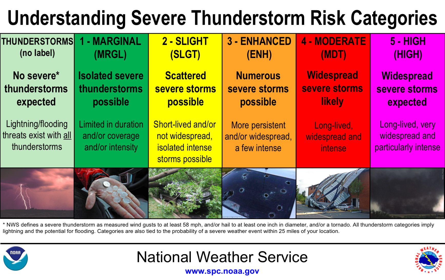
Understanding what are the risks and what do they mean – from the SPC.
There are 5 separate risks of severe weather storm potential. I generally consider it wise to remain weather aware no matter the risk.
note: I am aware the terms go from: ‘Marginal’ to ‘Slight’ to ‘Enhanced’ to ‘Moderate’ to ‘High’ as you go up higher severe thunderstorm potential. These are the terms as of today. This may or may not change to help improve forecast communication to viewers in the future.
note: I am aware improvements should be made for colorblind viewers.
Defining Each Risk Category
That being said, what are the risks and what do they mean? – from the Storm Prediction Center:
- Marginal risk (dark green) – Technically the lowest potential for severe weather. Severe storms of either limited organization and longevity, or very low coverage and marginal intensity.
- Slight risk (yellow) – Area of organized severe storms, which is not widespread in coverage with varying levels of intensity.
- Enhanced risk (orange) – An area of greater (relative to Slight risk) severe storm coverage with varying levels of intensity.
- Moderate risk (red) – Area where widespread severe weather with several tornadoes and/or numerous severe thunderstorms is likely, some of which should be intense. This risk is usually reserved for days with several supercells producing intense tornadoes and/or very large hail, or an intense squall line with widespread damaging winds.
- High risk (magenta) – Technically the highest potential for severe weather. A severe weather outbreak is expected. Either from numerous intense and long-tracked tornadoes or a long-lived derecho-producing thunderstorm complex that produces hurricane-force wind gusts and widespread damage. This risk is reserved for when high confidence exists in widespread coverage of severe weather with embedded instances of extreme severe (i.e., violent tornadoes or very damaging convective wind events).
How does a thunderstorm classify as severe?
When a thunderstorm produces any of the reports or indicates it on radar:
– Wind gusts 58+ mph
– Hail 1″+ diameter
– Tornado
Who is Praedictix? We are a weather company that focuses on delivering credible weather forecasts to our clients. We have three main offerings: media, weather graphics, and weather consulting.
Media: With two HD studios, we’re able to create professional weather forecast videos for use in television, social media, apps, and websites. Our forecasts are tailored to our clients’ brand. Our content ranges from national to hyperlocal forecasts and air all over the country.
Weather Graphics: We have access to a robust weather dataset which allows us to create high customizable, HD weather maps and graphics for use in television, digital signage, social media, and websites. Our white-label graphics allow our clients to push their own brands and sponsors.
Consulting: We lend our weather expertise to our clients to help with risk mitigation and business optimization by way of conference calls, emails, and briefings. We also have a forensic meteorology team that specializes in forensic weather analysis and expert testimony.
Click right HERE to learn more about us or contact us for your weather needs.

Joe Hansel
Lead Broadcast Meteorologist
Joe graduated with a bachelor’s in meteorology with a minor in mathematics from the University of North Dakota in Grand Forks. He also interned at Studio One in UND while earning awards as a student broadcaster and teaching assistant along the way. During summers off from college, Joe was the weather intern for the KSTP weather team based in the Twin Cities. Joe then worked as the morning meteorologist for 2 years at KCWY in Casper, Wyoming; then 4 years as the morning meteorologist at WSJV in South Bend-Elkhart, IN. There, Joe became a Certified Broadcast Meteorologist (CBM) through the American Meteorological Society and still owns the earned seal.