
El Niño Returns: What a Strong or Very Strong El Niño Could Mean for the Nation’s Winter Weather
A major climate pattern is developing in the tropical Pacific Ocean, and its influence could be felt across the United States in the months ahead. NOAA has announced that El Niño has developed, marking the return of the warm phase of the El Niño Southern Oscillation (ENSO). Forecast guidance suggests this El Niño could strengthen through the fall and potentially reach strong or very strong levels by the heart of winter.
While El Niño begins thousands of miles away in the Pacific Ocean, its impacts can extend across the globe by altering the jet stream, storm tracks, temperature patterns, and precipitation trends. For businesses and organizations that depend on weather, including transportation, agriculture, energy, construction, retail, insurance, and outdoor industries, understanding these large-scale patterns can provide valuable insight for planning ahead.
What Is El Niño?
El Niño (Spanish for “little boy”) occurs when ocean temperatures across the central and eastern tropical Pacific become warmer than average for several months. NOAA identifies El Niño when sea surface temperatures in the Niño monitoring region rise at least 0.5°C above average, along with corresponding changes in atmospheric circulation. During normal conditions, trade winds push warm ocean water westward across the tropical Pacific. During El Niño, those winds weaken, allowing warmer water to shift east toward South America. That change influences the atmosphere above the Pacific and can reshape weather patterns across North America.
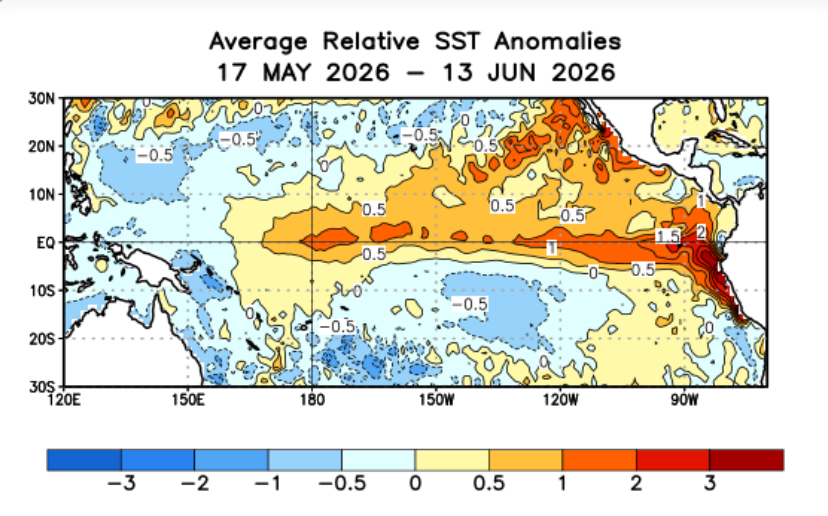
According to NOAA and the Columbia Climate School: “The equatorial Pacific is rapidly transitioning into El Niño conditions. While monthly SST anomalies remain near the borderline El Niño threshold, weekly values have surged well above it, with the last three weekly pentads firmly reaching +0.9 °C in the Niño3.4 region. This sharp warming strongly indicates that the currently near neutral seasonal averages will rise substantially in the coming months, marking a clear shift from ENSO neutral to El Niño conditions.”
“The latest CCSR/IRI ENSO plume forecast further supports this evolution, assigning a 98% probability to El Niño during May–July 2026 compared to only 2% for continued neutrality. El Niño conditions are then likely to persist through the remainder of 2026, with forecast probabilities consistently maintained within a remarkably high and narrow 97–98% range.”
How El Niño Influences U.S. Weather Patterns
El Niño is typically strongest during the Northern Hemisphere winter, which is when its influence on global weather patterns is often greatest.
A typical El Niño pattern can feature:
- A stronger southern branch of the jet stream
- More frequent storm systems across the southern U.S.
- Wetter conditions across parts of the southern tier
- A tendency toward warmer conditions across the northern U.S.
- Increased Pacific storm activity
However, every El Niño is different. The strength of the event, the location of the warmest ocean temperatures, and other atmospheric patterns all determine how the impacts unfold.
Why Does El Niño Matter
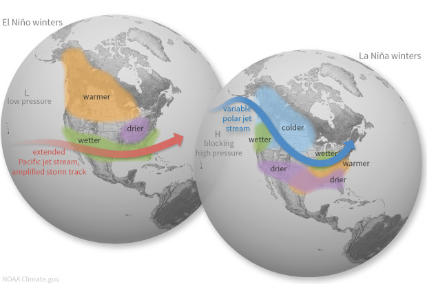
El Niño is typically strongest during the Northern Hemisphere winter, which is when its impacts are often felt the most across the United States. During a typical El Niño winter, the Pacific jet stream tends to shift south, sending more storms across the southern United States. This can bring increased precipitation chances to areas like California, the Southwest, and the Gulf Coast.
Meanwhile, the northern tier of the United State often trends warmer than average. Some El Niño winters are mild, while others bring major shifts in temperature and snowfall patterns. The strength of the El Niño, the location of warmer Pacific water, and other climate patterns all influence the final outcome.
Here is a look at all of the El Niño and La Niña episodes since 1950
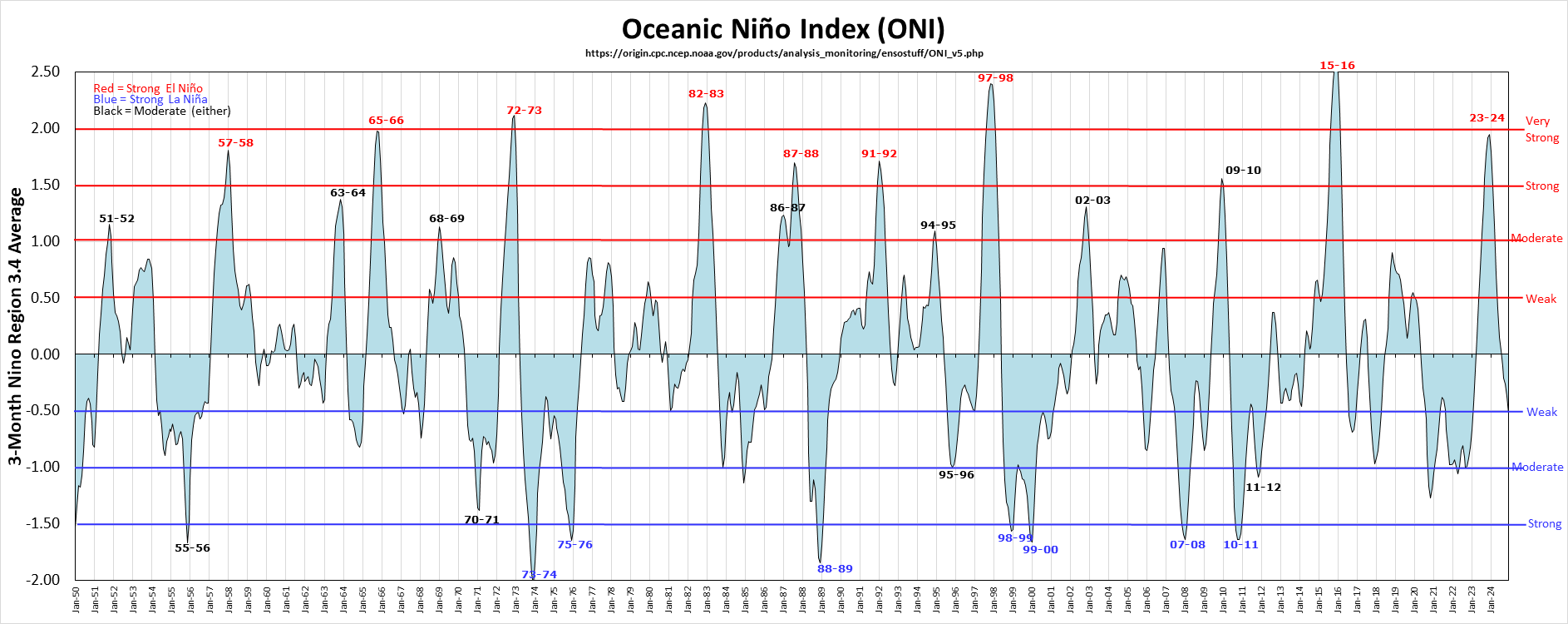
List of all El Nino and La Nina Events since 1950
Strong and Very Strong El Niño Events: What History Shows
Strong El Niño events are not all identical, but some have produced memorable weather impacts across the United States and around the Globe. Here’s a list of all the El Nino and La Nina events since 1950:
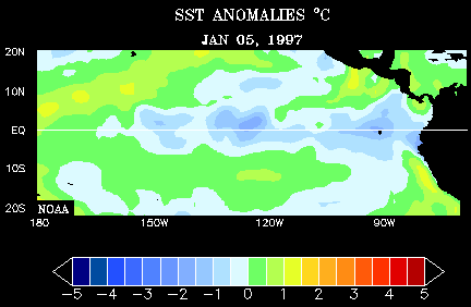
The 1997-98 Very Strong El Niño
The 1997-98 El Niño was one of the most powerful El Niño events ever observed, producing widespread weather impacts around the world. Exceptionally warm waters across the tropical Pacific disrupted global weather patterns, contributing to extreme drought, historic flooding, and billions of dollars in economic losses.
The impacts were felt across the United States, including record rainfall in California, a major drought in Indonesia, and one of the most significant tornado outbreaks in Florida history. The event also contributed to 1998 becoming the warmest year on record at the time.
The 1997-98 El Niño also had a major influence on tropical weather, increasing activity across parts of the Pacific with numerous intense tropical cyclones. It remains one of the clearest examples of how a powerful shift in Pacific Ocean temperatures can create far-reaching impacts across the planet.
See more from NOAA’s National Climactic Data Center HERE:
The 1982-83 Very Strong El Niño
The 1982-83 El Niño was one of the strongest and most impactful El Niño events on record. The event was so powerful that trade winds across the tropical Pacific weakened dramatically and even reversed, allowing a massive shift of warm ocean water eastward.
The impacts were felt around the world, from devastating drought and wildfires in parts of Australia and Indonesia to historic flooding in Peru. The event caused thousands of deaths and billions of dollars in damage globally.
The United States also experienced major impacts, including unusual temperature and precipitation patterns. The 1982-83 El Niño highlighted how changes in the Pacific Ocean can influence weather patterns across the globe, and even produced measurable changes in Earth’s atmosphere and circulation.
See more about the Very Strong El Nino Event from Woods Hole Oceanic Institution HERE:
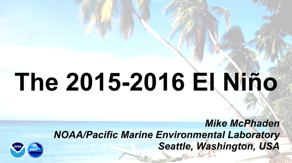
The 2015-16 Very Strong El Niño
The 2015–16 El Niño was one of the strongest on record, peaking with sea surface temperature anomalies in the central-eastern equatorial Pacific exceeding 2.3°C above average. This “super” El Niño caused severe global climate disruptions, including devastating droughts in Africa, record-breaking hurricanes in the Pacific, and massive contributions to historic global temperature spikes.
Peak Intensity: Reached levels rivaling the historic 1982–83 and 1997–98 events, characterized by significantly weaker trade winds and highly unusual warm water displacement. Global Temperatures: Along with underlying climate change, this event made 2015 and 2016 some of the warmest years in recorded history.
Major Impacts: Tropical Cyclones: Spurred a record-shattering 16 tropical cyclones in the Central Pacific basin while simultaneously limiting Atlantic hurricane activity due to strong wind shear. Droughts & Food Security: Caused severe droughts and water shortages in regions such as Ethiopia, the Caribbean, and parts of Central America. Localized Anomalies: Despite being an incredibly strong event, it produced less precipitation than historically expected in drought-prone areas like California.
See a youtube video from NOAA Here
What Could This Mean for the Upcoming Winter?
If this El Niño continues to strengthen, it could help shape the overall weather pattern across the United States this winter. While El Niño does not determine the exact forecast months in advance, it can provide valuable clues about where storms may track, where temperatures may trend warmer or cooler, and where weather risks could increase.
For businesses and communities, these large-scale pattern changes can have real-world impacts.
A More Active Storm Track for Some Areas
One of the biggest changes during El Niño winters is often the position of the jet stream. A stronger southern storm track can increase the chance for more frequent storm systems across the southern U.S.
That can lead to periods of:
- Heavy rainfall
- Increased flooding concerns
- Travel disruptions
- Transportation and supply chain challenges
- Changes in construction and outdoor operations
For industries sensitive to weather, even a few major storms can create significant operational impacts.
Winter Weather Is Still on the Table
A common misconception is that El Niño means a mild or snow-free winter everywhere. While many El Niño winters do trend warmer across parts of the northern U.S., winter weather can still make an impact. The right combination of cold air, moisture, and storm timing can still produce:
- Major snowstorms
- Ice events
- Arctic cold outbreaks
- Hazardous travel conditions
History has shown that even during strong and very strong El Niño events, significant winter storms can still occur.
Expect More Variability
One of the defining characteristics of El Niño winters can be big swings in weather conditions. As the jet stream shifts and storm systems move across the country, temperatures can change quickly. It can create stretches of mild weather followed by sharp cold snaps. For organizations making plans, the key takeaway is this: El Niño can help identify broad trends, but the details matter. Monitoring how the pattern evolves and how individual storms develop will be critical throughout the season.
Here is the ENSO (El Niño Southern Oscillation) forecast by a number of different models as we approach the upcoming Fall and Winter. Note Dynamic and Static Average of the models in the BOLD Green and Red lines show a consensus toward temperatures nearing that 2F or Very Strong El Niño threshold.
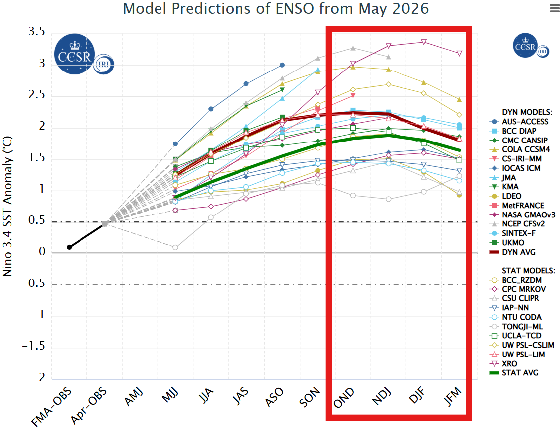
ENSO Forecast
How El Niño Can Impact Businesses and Operations
Weather is a factor that can influence daily operations, staffing, safety, costs, and long-term planning. Large-scale climate patterns like El Niño can provide important signals about the type of weather risks that may become more likely. While El Niño does not predict every storm or temperature swing, understanding the broader pattern can help organizations prepare for potential impacts.
Transportation & Logistics
Winter weather can quickly disrupt transportation networks, and even a few major storms can create widespread challenges. Changes in storm tracks during El Niño winters may influence:
- Road conditions and travel safety
- Flight delays and cancellations
- Shipping schedules
- Delivery timelines
- Supply chain reliability
For companies moving people, products, or materials, having advance awareness of potential weather risks can help improve planning and reduce disruptions.
Energy & Utilities
Weather patterns have a direct impact on energy demand and production. A warmer-than-average winter may reduce heating demand in some areas, while sudden cold snaps can still create significant spikes in energy usage. El Niño-related weather changes can influence:
- Heating and energy demand
- Renewable energy production, including wind and solar
- Grid planning and resource management
- Maintenance and field operations
Understanding the potential range of conditions helps energy providers and operators better prepare for changing demand.
Construction & Outdoor Operations
For weather-sensitive industries, timing is everything. Temperature swings, precipitation, and winter storms can affect:
- Construction schedules
- Frozen ground conditions
- Equipment access
- Worker safety
- Project timelines
Even during a warmer winter pattern, a single major storm or extended cold period can create operational challenges.
Agriculture & Natural Resources
Weather patterns throughout the winter can influence conditions well beyond the season itself. El Niño may impact:
- Soil moisture conditions
- Snowpack and water availability
- Spring planting conditions
- Crop planning decisions
- Commodity markets
Understanding large-scale climate trends can help agricultural businesses better prepare for possible changes in growing conditions.
How Praedictix Helps Businesses Prepare
Long-range climate patterns provide valuable background information, but operational decisions require more detailed forecasting. Praedictix helps organizations translate weather data into actionable intelligence through:
- Customized weather forecasting
- Operational weather briefings
- Severe weather and lightning alerts
- Weather risk management
- Historical and forensic weather analysis
- Force Majeure Claims
- Industry-specific forecasting solutions
- Online weather portal to access customized weather data
Our team of meteorologists works with organizations to understand how weather impacts their operations and provide the information needed to plan ahead.