
National Weather Forecast
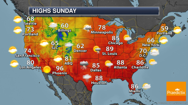
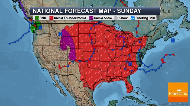
On Sunday, showers and storms will be possible across a good portion of the central and eastern United States with several low-pressure areas in play. However, big cities such as Boston, New York City, and Washington D.C. should remain dry. A few rain/snow showers will be possible in the northern and central Rockies, with a few rain showers in the Pacific Northwest with a cold front nearby.
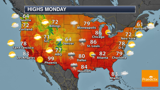
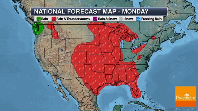
As we head into Memorial Day Monday, more storms will be possible across the mid-section of the nation stretching into the Southeast. Some rain will also be possible in the Pacific Northwest. A few record highs will be possible in the Ohio Valley.
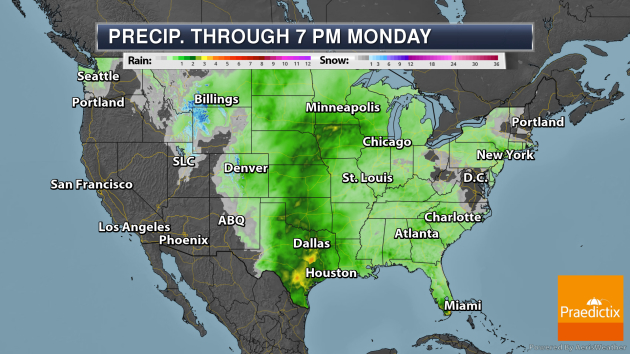
A swath of 2-4″ of rain will be possible through Memorial Day across central portions of the nation. Snow is still falling in portions of the west, with several inches possible in the Northern Rockies.
_______________________________________________
Snow Out West
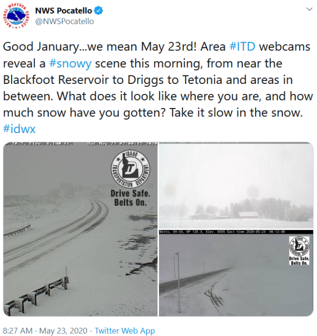
Geeze… it feels like 2020 just keeps kicking us. Snow has been falling Saturday out in the Northern Rockies, with 8″ of snow reported near Wayan, ID, and 4.3″ near Goshen, ID.
_______________________________________________
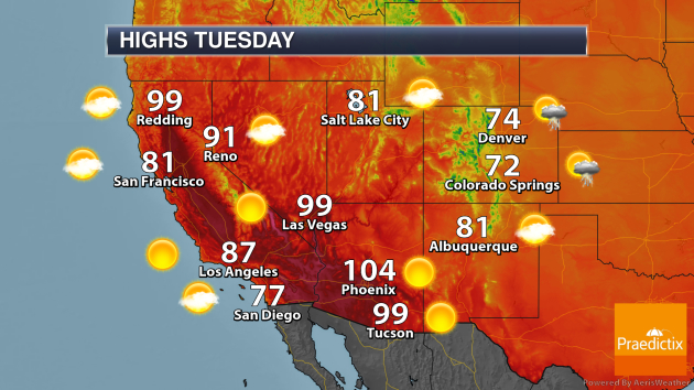
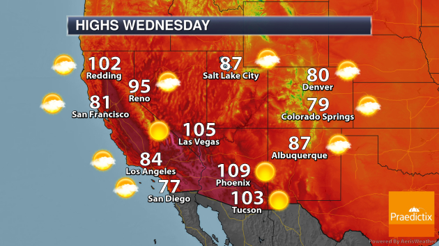
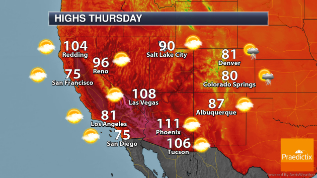
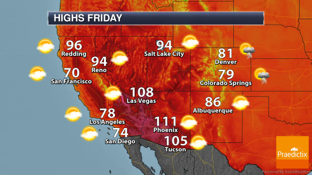
Heat Builds In The Southwest
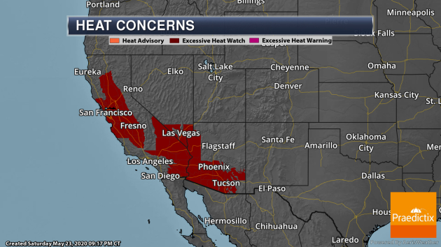
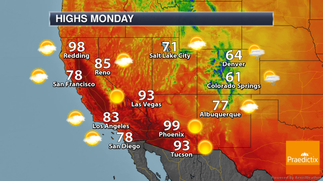
As we head into the last week of May, heat will once again build across portions of the Southwest, with Excessive Heat Watches in place. In San Francisco these are in place from Monday through Thursday. In Las Vegas and Phoenix, they are in place from Wednesday through Friday. Here’s a look at expected highs across the Southwest from Monday through Friday:
_______________________________________________
See a wild underwater ‘benthic tornado’ whirl across the sea floor

More from CNET: “Here’s the weather forecast for the Coral Sea Marine Park seafloor off the coast of Australia: wet with a chance of tornadoes. Researchers following a Schmidt Ocean Institute ROV (remotely operated vehicle) dive near Queensland spotted a wild event when a tornado-like formation appeared on camera during a livestream on Thursday.”
A clue as to why it’s so hard to wake up on a cold winter’s morning
More from Northwestern University: “Winter may be behind us, but do you remember the challenge of waking up on those cold, dark days? Temperature affects the behavior of nearly all living creatures, but there is still much to learn about the link between sensory neurons and neurons controlling the sleep-wake cycle. Northwestern University neurobiologists have uncovered a clue to what’s behind this behavior. In a study of the fruit fly, the researchers have identified a “thermometer” circuit that relays information about external cold temperature from the fly antenna to the higher brain. They show how, through this circuit, seasonally cold and dark conditions can inhibit neurons within the fly brain that promote activity and wakefulness, particularly in the morning.”
Nitrogen Dioxide Levels Rebound in China
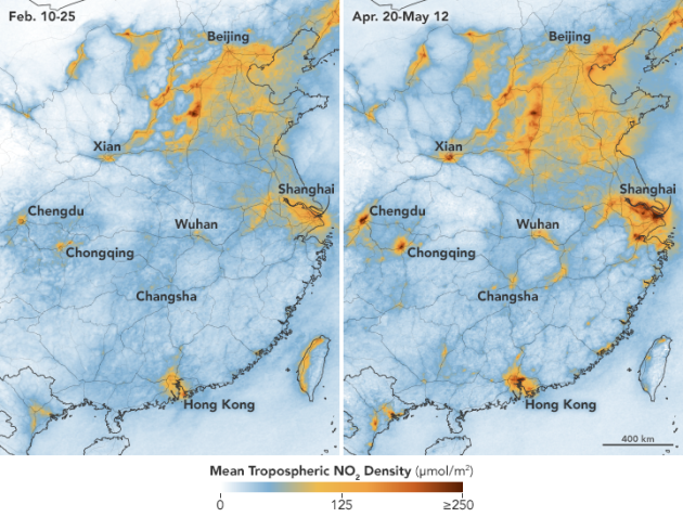
Image: NASA Earth Observatory images by Joshua Stevens, using Ozone Monitoring Instrument (OMI) data from the NASA Goddard Earth Sciences Data and Information Services Center (GES DISC), and modified Copernicus Sentinel 5P data processed by the European Space Agency.
More from NASA: “In early February 2020, scientists using NASA and European satellites detected a significant reduction in a key air pollutant over China after the country shut down transportation and much of its economy. Three months later, with most coronavirus (COVID-19) lockdowns ending in China and economic activity resuming, the levels of nitrogen dioxide over the country have returned to near normal for this time of year. Scientists expected this rebound.”
_______________________________________________
Thanks for checking in and have a great Sunday! Don’t forget to follow me on Twitter (@dkayserwx) and like me on Facebook (Meteorologist D.J. Kayser)!
– D.J. Kayser
